Kitzsteinhorn summit · 3,029 m · Feratel

Camera image unavailable
Camera image · refreshes every 60 seconds while visible.
Open camera page ↗
各色は表示された値から始まります。風の色は3種類の単位で対応しています。降水のないセルは中立色です。色は表示値を示すもので、公的な気象警報ではありません。
ECMWF · モデル計算時刻: 次回更新予定:
日 時刻(UTC) 気温(°C) 湿度(%) 風速(km/h) 風速(ノット) 風(ビューフォート) 風向 降水量(mm) 降雪量(cm) 気圧(hPa) 0°C高度(m) 天気 | 水曜日, 04/11 06:00 1.9 72 2 1 1B S — — 1025 < 1525 Overcast 90% cloud  09:00 5.9 67 2 1 1B E 0.03 0 1025 1999 Overcast 93% cloud 12:00 8.6 60 3 1 1B E 0.09 0 1024 2299 Partly cloudy 33% cloud  15:00 7.5 64 1 0 0B E 0 0 1023 2289 Partly cloudy 21% cloud 18:00 3.4 70 2 1 1B S 0.00 0 1024 1551 Clear 20% cloud  21:00 2.1 66 4 2 1B S 0 0 1025 < 1525 Partly cloudy 48% cloud 木曜日, 05/11 00:00 1 67 3 1 1B S 0 0 1026 < 1525 Partly cloudy 42% cloud 03:00 1.1 63 2 1 1B S 0 0 1025 < 1525 Partly cloudy 26% cloud 06:00 2.2 55 2 1 1B S 0 0 1025 < 1525 Clear 19% cloud 09:00 8.9 48 1 1 1B E 0 0 1024 2954 Clear 16% cloud 12:00 12.3 40 1 1 1B NE 0 0 1022 3079 Clear 7% cloud 15:00 9.8 49 0 0 0B S 0 0 1022 3123 Clear 3% cloud 18:00 5.4 49 1 1 1B S 0 0 1023 3129 Clear 2% cloud 21:00 5.9 46 1 0 0B S 0 0 1023 3127 Clear 1% cloud 金曜日, 06/11 00:00 5.5 43 1 0 0B S 0 0 1022 3119 Clear 0% cloud 03:00 5.5 37 1 0 0B S 0 0 1021 3109 Clear 0% cloud 06:00 5.7 32 1 1 0B S 0 0 1020 3105 Clear 0% cloud 09:00 11.3 33 2 1 1B NE 0 0 1019 3105 Clear 0% cloud 12:00 13.6 35 2 1 1B NE 0 0 1017 3097 Clear 0% cloud 15:00 10.3 47 0 0 0B SE 0 0 1017 3092 Clear 1% cloud 18:00 4.2 54 1 1 1B SW 0 0 1018 2488 Clear 3% cloud 21:00 3.4 58 2 1 1B SW 0 0 1020 1596 Clear 9% cloud 土曜日, 07/11 00:00 1.7 58 2 1 1B SW 0 0 1021 < 1525 Clear 19% cloud 03:00 2.5 53 1 1 0B SW 0 0 1021 < 1525 Cloudy 64% cloud  06:00 2.3 56 1 0 0B W 0 0 1022 < 1525 Cloudy 51% cloud 09:00 6.8 51 2 1 1B N 0 0 1023 2261 Partly cloudy 45% cloud 12:00 9.2 44 3 2 1B NE 0 0 1021 2401 Overcast 81% cloud 15:00 7.5 51 0 0 0B N 0 0 1021 2265 Cloudy 64% cloud 18:00 3 60 2 1 1B SW 0 0 1022 < 1525 Partly cloudy 45% cloud 21:00 2.1 57 2 1 1B S 0 0 1023 < 1525 Partly cloudy 37% cloud 日曜日, 08/11 00:00 2 56 2 1 1B S 0 0 1023 < 1525 Clear 19% cloud 03:00 1.4 60 1 1 1B S 0 0 1023 < 1525 Clear 10% cloud 06:00 1.2 63 2 1 1B S 0.11 0 1023 < 1525 Overcast 88% cloud 09:00 5.7 56 1 1 0B E 2.2 0 1024 1885 Cloudy 62% cloud 12:00 8.2 50 0 0 0B E 0.00 0 1023 2110 Partly cloudy 26% cloud 15:00 6.1 58 0 0 0B E 0 0 1022 1922 Partly cloudy 22% cloud 18:00 1.2 65 3 2 1B S 0 0 1023 < 1525 Partly cloudy 28% cloud 21:00 -0.6 64 4 2 1B S 0 0 1023 < 1525 Partly cloudy 45% cloud 月曜日, 09/11 00:00 0.4 54 3 2 1B S 0 0 1022 < 1525 Clear 14% cloud 03:00 2 45 2 1 1B S 0 0 1021 < 1525 Overcast 95% cloud 06:00 5.1 41 2 1 1B SE 0.00 0 1021 1962 Overcast 97% cloud 09:00 8.5 39 1 1 0B NE 0.00 0 1020 2488 Cloudy 71% cloud 12:00 11 37 1 1 1B SE 0 0 1017 2701 Overcast 85% cloud 15:00 8.3 50 1 1 1B S 0 0 1016 2656 Partly cloudy 25% cloud 18:00 4.1 57 4 2 1B S 0 0 1015 1977 Overcast 86% cloud 21:00 4.8 59 4 2 1B S 0 0 1016 2569 Overcast 96% cloud 火曜日, 10/11 00:00 4.6 62 3 2 1B S 0.01 0 1015 2462 Overcast 100% cloud 03:00 6.2 65 3 2 1B S 0.01 0 1013 2826 Overcast 100% cloud 06:00 4.6 66 3 2 1B S 0.01 0 1012 2833 Overcast 92% cloud |
|---|
Forecast table times: UTC.
Coordinates: 47.27358041°N, 12.74731636°E · Requested elevation: 911 m. Model terrain: 1522 m. Terrain and 1000/925/850/700 hPa profiles are used for height estimates.
Outside the available profile, temperature uses an estimated 5.5°C/km height correction; wind retains the nearest available model-level value. Humidity is estimated with adjusted pressure and temperature.
These are altitude estimates, not a simulation of local mountain terrain. Precipitation, cloud and sea-level pressure use horizontal interpolation only.
Precipitation includes rain and snow water equivalent: preceding 3 hours through day 6, then 6 hours (see cell tooltip). Snow (cm) estimates fresh snowfall from precipitation and temperature using the GFS conversion; it is not snow depth on the ground. Freezing (m) uses additional 600/500 hPa temperatures when available and estimates the lowest resolved 0°C crossing above sea level. When all sampled levels are warm, the upper profile limit is shown (see tooltip). < marks an entirely cold sampled profile and its lower height limit. No extrapolation is used.
Source: ECMWF · CC BY 4.0 · Processed by Snow Report.
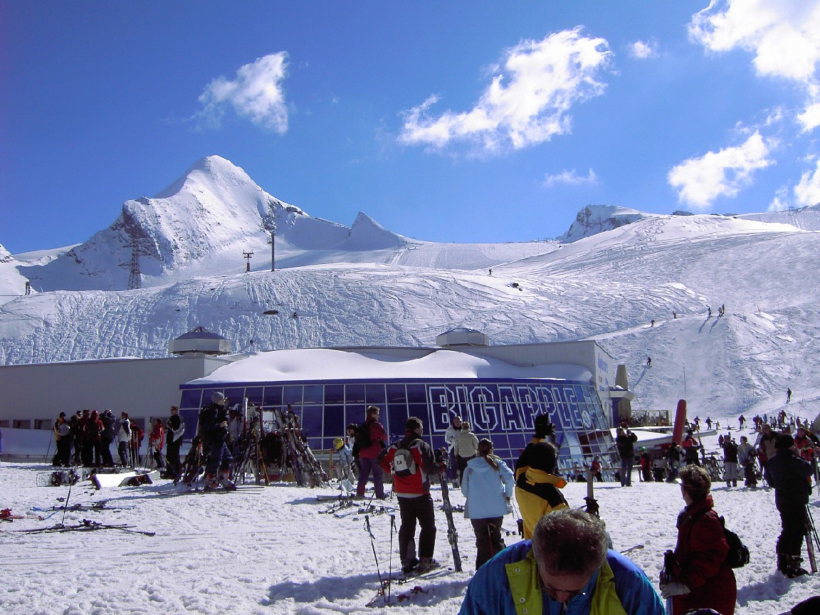
Kaprun brings together the lower Maiskogel mountain and the Kitzsteinhorn glacier area. The MK Maiskogelbahn and 3K K-onnection allow an ascent from Kaprun through Maiskogel towards the glacier, while the Gletscherjet valley station offers another starting point. It is worth identifying your departure station before choosing transport or checking the day’s lift information.
This page opens at 911 m, a lower reference in the Kaprun area. That is a very different setting from the glacier. A warm or rainy forecast at the selected point is not a report of conditions throughout Kitzsteinhorn. Choose one of the higher forecast points when planning a mountain day, and compare it with the lower point for your return.
For families or groups with different plans, Maiskogel and the glacier need not be treated as the same outing. Check the facilities you intend to use rather than relying on a single headline for the entire destination. During changing weather, follow the wind and cloud forecast as well as the amount of fresh snow. The operator’s current report confirms which parts of the lift route and pistes are actually available.
Official sources: Kitzsteinhorn — Kaprun–Maiskogel connection · Kaprun skiing. Reviewed 18 October 2026.
Camera image · refreshes every 60 seconds while visible.
Open camera page ↗
Camera image · refreshes every 60 seconds while visible.
Open camera page ↗
Camera image · refreshes every 60 seconds while visible.
Open camera page ↗ECMWF · モデル計算時刻: 次回更新予定:
日 時刻(UTC) 気温(°C) 湿度(%) 風速(km/h) 風速(ノット) 風(ビューフォート) 風向 降水量(mm) 降雪量(cm) 気圧(hPa) 0°C高度(m) 天気 | 水曜日, 04/11 06:00 -3 85 7 4 2B SE — — 1025 < 1645 Overcast 91% cloud 09:00 0.1 81 7 4 2B SE 0.06 0 1025 1992 Overcast 93% cloud 12:00 2 74 7 4 2B SE 0.07 0 1024 2271 Partly cloudy 39% cloud 15:00 1.3 75 5 2 1B SE 0 0 1024 2226 Partly cloudy 31% cloud 18:00 -1.5 76 5 3 1B S 0.02 0 1025 < 1645 Partly cloudy 27% cloud 21:00 -2.2 71 6 3 2B S 0 0 1026 < 1645 Cloudy 63% cloud 木曜日, 05/11 00:00 -2.8 68 5 3 1B S 0 0 1026 < 1645 Partly cloudy 45% cloud 03:00 -2.6 63 4 2 1B S 0 0 1025 < 1645 Partly cloudy 21% cloud 06:00 -1.8 56 3 2 1B S 0 0 1025 < 1645 Clear 14% cloud 09:00 3.6 51 2 1 1B S 0 0 1025 2925 Clear 12% cloud 12:00 6.1 44 1 1 1B S 0 0 1023 3052 Clear 5% cloud 15:00 4.1 52 1 1 1B S 0 0 1022 3108 Clear 2% cloud 18:00 0.5 50 3 1 1B S 0 0 1023 3129 Clear 1% cloud 21:00 0.9 46 3 1 1B S 0 0 1023 3127 Clear 1% cloud 金曜日, 06/11 00:00 0.7 42 3 1 1B S 0 0 1022 3119 Clear 0% cloud 03:00 0.7 37 2 1 1B S 0 0 1021 3109 Clear 0% cloud 06:00 0.9 34 2 1 1B S 0 0 1020 3105 Clear 0% cloud 09:00 5.7 34 3 1 1B SE 0 0 1019 3105 Clear 0% cloud 12:00 7.3 37 2 1 1B S 0 0 1018 3097 Clear 0% cloud 15:00 4.5 50 2 1 1B S 0 0 1018 3092 Clear 1% cloud 18:00 -0 57 4 2 1B S 0 0 1018 1894 Clear 0% cloud 21:00 -0.9 59 6 3 2B S 0 0 1020 < 1645 Clear 2% cloud 土曜日, 07/11 00:00 -2.3 58 8 4 2B S 0 0 1021 < 1645 Partly cloudy 22% cloud 03:00 -1.5 56 7 4 2B S 0 0 1021 < 1645 Cloudy 74% cloud 06:00 -1.8 58 7 4 2B S 0 0 1022 < 1645 Cloudy 64% cloud 09:00 1.3 56 7 4 2B SE 0 0 1023 2237 Cloudy 59% cloud 12:00 2.7 51 9 5 2B SE 0 0 1021 2370 Overcast 84% cloud 15:00 1.3 63 8 5 2B S 0 0 1021 2205 Cloudy 68% cloud 18:00 -2.2 68 9 5 2B S 0.02 0 1023 < 1645 Partly cloudy 46% cloud 21:00 -2.8 70 8 4 2B S 0 0 1024 < 1645 Partly cloudy 43% cloud 日曜日, 08/11 00:00 -2.8 70 5 3 1B S 0 0 1023 < 1645 Partly cloudy 28% cloud 03:00 -3.6 73 4 2 1B SW 0.01 0 1023 < 1645 Clear 18% cloud 06:00 -3.8 78 5 2 1B SW 0.13 0.1 1024 < 1645 Overcast 90% cloud 09:00 -0.5 72 3 2 1B SW 1.8 0.5 1025 1896 Cloudy 62% cloud 12:00 1.3 65 4 2 1B W 0.00 0 1023 2126 Partly cloudy 38% cloud 15:00 -0.4 73 3 2 1B W 0 0 1022 1917 Partly cloudy 25% cloud 18:00 -3.9 74 5 2 1B W 0 0 1023 < 1645 Partly cloudy 28% cloud 21:00 -5.3 67 6 3 2B W 0 0 1023 < 1645 Partly cloudy 43% cloud 月曜日, 09/11 00:00 -4.5 57 6 3 2B W 0 0 1023 < 1645 Clear 12% cloud 03:00 -2.8 51 6 3 2B W 0 0 1021 < 1645 Overcast 93% cloud 06:00 -0.4 53 6 3 1B SW 0.02 0 1021 1858 Overcast 94% cloud 09:00 2.8 48 5 3 1B W 0 0 1020 2506 Cloudy 63% cloud 12:00 4.8 48 5 2 1B W 0 0 1018 2713 Overcast 85% cloud 15:00 2.7 59 5 3 1B SW 0 0 1016 2637 Partly cloudy 26% cloud 18:00 -0.4 71 8 5 2B W 0 0 1016 < 1645 Overcast 87% cloud 21:00 0.2 69 7 4 2B SW 0 0 1016 2248 Overcast 95% cloud 火曜日, 10/11 00:00 -0 75 7 4 2B SW 0 0 1016 1953 Overcast 99% cloud 03:00 1.5 80 9 5 2B W 0 0 1014 2793 Overcast 99% cloud 06:00 0.2 81 9 5 2B W 0 0 1013 2574 Overcast 93% cloud |
|---|
Forecast table times: UTC.
Coordinates: 47.22090889°N, 12.69907951°E · Requested elevation: 1970 m. Model terrain: 1643 m. Terrain and 1000/925/850/700 hPa profiles are used for height estimates.
These are altitude estimates, not a simulation of local mountain terrain. Precipitation, cloud and sea-level pressure use horizontal interpolation only.
Precipitation includes rain and snow water equivalent: preceding 3 hours through day 6, then 6 hours (see cell tooltip). Snow (cm) estimates fresh snowfall from precipitation and temperature using the GFS conversion; it is not snow depth on the ground. Freezing (m) uses additional 600/500 hPa temperatures when available and estimates the lowest resolved 0°C crossing above sea level. When all sampled levels are warm, the upper profile limit is shown (see tooltip). < marks an entirely cold sampled profile and its lower height limit. No extrapolation is used.
Source: ECMWF · CC BY 4.0 · Processed by Snow Report.
ECMWF · モデル計算時刻: 次回更新予定:
日 時刻(UTC) 気温(°C) 湿度(%) 風速(km/h) 風速(ノット) 風(ビューフォート) 風向 降水量(mm) 降雪量(cm) 気圧(hPa) 0°C高度(m) 天気 | 水曜日, 04/11 06:00 -6.1 81 22 12 4B SE — — 1025 < 1732 Overcast 92% cloud 09:00 -5.7 84 26 14 4B SE 0.08 0.1 1025 1979 Overcast 94% cloud 12:00 -5.2 79 24 13 4B SE 0.07 0.1 1024 2242 Partly cloudy 47% cloud 15:00 -4.3 67 15 8 3B S 0 0 1024 2180 Partly cloudy 39% cloud 18:00 -3.4 50 13 7 3B S 0.02 0 1025 < 1732 Partly cloudy 35% cloud 21:00 -3 44 12 6 2B S 0 0 1027 < 1732 Cloudy 69% cloud 木曜日, 05/11 00:00 -2.5 34 11 6 2B S 0 0 1027 < 1732 Partly cloudy 43% cloud 03:00 -1.8 30 11 6 2B S 0 0 1026 < 1732 Clear 18% cloud 06:00 -1.3 33 10 5 2B SW 0 0 1025 < 1732 Clear 11% cloud 09:00 -0.5 30 9 5 2B S 0 0 1025 2898 Clear 10% cloud 12:00 0 27 6 3 2B S 0 0 1023 3032 Clear 4% cloud 15:00 0.2 26 4 2 1B S 0 0 1023 3094 Clear 2% cloud 18:00 0.1 24 7 4 2B SE 0 0 1023 2086 Clear 1% cloud 21:00 0.3 22 8 4 2B S 0 0 1023 3127 Clear 1% cloud 金曜日, 06/11 00:00 0.3 22 8 4 2B S 0 0 1022 3119 Clear 0% cloud 03:00 0.4 19 6 3 2B S 0 0 1021 3109 Clear 0% cloud 06:00 0.7 18 6 3 2B S 0 0 1020 3105 Clear 0% cloud 09:00 1 18 9 5 2B S 0 0 1020 3105 Clear 0% cloud 12:00 0.8 22 10 5 2B S 0 0 1018 3097 Clear 0% cloud 15:00 0.2 29 7 4 2B S 0 0 1018 3082 Clear 1% cloud 18:00 -0.7 35 11 6 2B SE 0 0 1019 < 1732 Clear 0% cloud 21:00 -1.3 30 21 11 4B S 0 0 1021 < 1732 Clear 2% cloud 土曜日, 07/11 00:00 -2.2 27 26 14 4B S 0 0 1021 < 1732 Partly cloudy 30% cloud 03:00 -2.8 35 26 14 4B S 0 0 1021 < 1732 Cloudy 78% cloud 06:00 -3.5 36 28 15 4B S 0 0 1022 < 1732 Cloudy 71% cloud 09:00 -4 46 31 17 5B SE 0 0 1024 2204 Cloudy 65% cloud 12:00 -4.7 46 36 19 5B SE 0 0 1021 2350 Overcast 85% cloud 15:00 -4.6 71 34 18 5B S 0 0 1022 2153 Cloudy 70% cloud 18:00 -5.2 60 33 18 5B S 0.04 0 1023 < 1732 Partly cloudy 43% cloud 21:00 -6.1 83 26 14 4B S 0 0 1024 < 1732 Partly cloudy 48% cloud 日曜日, 08/11 00:00 -6.1 81 15 8 3B SW 0 0 1024 < 1732 Partly cloudy 37% cloud 03:00 -6.6 73 14 8 3B SW 0.02 0 1023 < 1732 Partly cloudy 24% cloud 06:00 -7 81 14 8 3B SW 0.16 0.2 1024 < 1732 Overcast 90% cloud 09:00 -7.6 84 15 8 3B SW 1.4 1.4 1025 1884 Cloudy 65% cloud 12:00 -7.7 81 15 8 3B W 0.01 0 1023 2124 Partly cloudy 44% cloud 15:00 -7.7 81 13 7 3B W 0 0 1023 1909 Partly cloudy 28% cloud 18:00 -6.9 58 18 10 3B W 0 0 1024 < 1732 Partly cloudy 30% cloud 21:00 -6.2 33 23 12 4B W 0 0 1024 < 1732 Partly cloudy 40% cloud 月曜日, 09/11 00:00 -5.5 29 24 13 4B W 0 0 1023 < 1732 Clear 11% cloud 03:00 -4.5 38 23 12 4B W 0 0 1021 < 1732 Overcast 91% cloud 06:00 -4 68 22 12 4B W 0.02 0 1021 < 1732 Overcast 91% cloud 09:00 -2.7 62 21 11 4B W 0 0 1021 2496 Cloudy 61% cloud 12:00 -2 61 21 12 4B W 0 0 1018 2710 Overcast 84% cloud 15:00 -1.6 55 20 11 4B W 0 0 1017 2607 Partly cloudy 27% cloud 18:00 -1.4 76 31 17 5B W 0 0 1017 < 1732 Overcast 87% cloud 21:00 -0.7 62 22 12 4B SW 0 0 1017 < 1732 Overcast 94% cloud 火曜日, 10/11 00:00 -0.7 74 24 13 4B W 0 0 1016 < 1732 Overcast 98% cloud 03:00 -0.4 86 33 18 5B W 0 0 1014 2726 Overcast 99% cloud 06:00 -0.2 83 34 18 5B W 0 0 1013 < 1732 Overcast 93% cloud |
|---|
Forecast table times: UTC.
Coordinates: 47.18965414°N, 12.68517494°E · Requested elevation: 3028 m. Model terrain: 1729 m. Terrain and 1000/925/850/700 hPa profiles are used for height estimates.
These are altitude estimates, not a simulation of local mountain terrain. Precipitation, cloud and sea-level pressure use horizontal interpolation only.
Precipitation includes rain and snow water equivalent: preceding 3 hours through day 6, then 6 hours (see cell tooltip). Snow (cm) estimates fresh snowfall from precipitation and temperature using the GFS conversion; it is not snow depth on the ground. Freezing (m) uses additional 600/500 hPa temperatures when available and estimates the lowest resolved 0°C crossing above sea level. When all sampled levels are warm, the upper profile limit is shown (see tooltip). < marks an entirely cold sampled profile and its lower height limit. No extrapolation is used.