Previsiones para estaciones de esquí de todo el mundo

Guía de colores Temperatura · Viento · Lluvia · Nieve
Cada color comienza en el valor indicado. Los colores del viento coinciden en las tres unidades. Las celdas sin precipitación permanecen neutras. Los colores describen los valores mostrados, no son avisos meteorológicos oficiales.
Courmayeur - base
ECMWF · Ejecución del modelo: Próxima actualización prevista:
Día Hora (UTC) Temp. (°C) Humedad (%) Viento (km/h) Viento (nudos) Viento (Bft) Dirección Precip. (mm) Nieve nueva (cm) Presión (hPa) Isoterma de 0 °C (m) Condiciones | Miércoles, 04/11 06:00 1.4 69 3 2 1B NE — — 1023 < 2161 Overcast 84% cloud  09:00 3.4 63 5 3 1B NE 0.40 0 1024 < 2161 Overcast 97% cloud 12:00 4.4 60 6 3 2B E 0.71 0 1024 < 2161 Overcast 100% cloud 15:00 3.7 66 6 3 1B E 0.55 0 1024 < 2161 Overcast 91% cloud 18:00 2.4 71 5 2 1B E 0.57 0 1025 < 2161 Overcast 91% cloud 21:00 2.2 69 4 2 1B E 0.37 0 1027 < 2161 Overcast 91% cloud Jueves, 05/11 00:00 2.4 70 5 3 1B E 0.49 0 1027 < 2161 Overcast 96% cloud 03:00 2.4 69 5 3 1B E 0.39 0 1027 < 2161 Overcast 97% cloud 06:00 2.5 69 4 2 1B E 0.33 0 1027 < 2161 Overcast 91% cloud 09:00 5 64 5 3 1B E 0.28 0 1028 < 2161 Overcast 83% cloud 12:00 6.5 59 5 3 1B E 0 0 1027 2414 Overcast 91% cloud 15:00 6.3 63 3 2 1B E 0 0 1025 2392 Cloudy 79% cloud  18:00 3.4 71 2 1 1B E 0 0 1025 < 2161 Cloudy 72% cloud 21:00 3.4 72 2 1 1B NE 0.22 0 1026 < 2161 Overcast 97% cloud Viernes, 06/11 00:00 3.7 73 3 1 1B NE 0.09 0 1024 < 2161 Overcast 99% cloud 03:00 3.6 73 3 1 1B E 0.27 0 1023 < 2161 Overcast 99% cloud 06:00 3.6 74 3 2 1B E 0.20 0 1022 < 2161 Overcast 99% cloud 09:00 4.9 73 3 1 1B E 1.0 0 1023 < 2161 Overcast 100% cloud 12:00 5.1 72 2 1 1B NE 2.7 0 1022 < 2161 Overcast 100% cloud 15:00 4.8 73 2 1 1B N 0.84 0 1021 < 2161 Overcast 95% cloud 18:00 3.8 77 2 1 1B NW 2.1 0 1022 < 2161 Overcast 100% cloud 21:00 3.7 75 2 1 1B W 3.3 0 1022 < 2161 Overcast 100% cloud Sábado, 07/11 00:00 3.4 75 1 0 0B NW 2.6 0 1023 < 2161 Overcast 100% cloud 03:00 3.2 75 1 1 0B NW 0.39 0 1022 < 2161 Overcast 100% cloud 06:00 2.9 74 0 0 0B NW 0.14 0 1023 < 2161 Overcast 100% cloud 09:00 3.9 71 3 2 1B E 0 0 1023 < 2161 Overcast 91% cloud 12:00 4.6 64 3 2 1B NE 0 0 1023 < 2161 Overcast 89% cloud 15:00 4.1 68 2 1 1B NE 0.12 0 1023 < 2161 Overcast 95% cloud 18:00 1.9 72 1 1 0B N 0.28 0 1024 < 2161 Overcast 88% cloud 21:00 1 71 1 0 0B W 0.09 0 1025 < 2161 Overcast 90% cloud Domingo, 08/11 00:00 -0.8 67 2 1 1B W 0.09 0 1025 < 2161 Cloudy 77% cloud 03:00 -1.5 60 2 1 1B W 0 0 1025 < 2161 Partly cloudy 49% cloud  06:00 -2.2 57 1 1 1B W 0 0 1025 < 2161 Partly cloudy 32% cloud 09:00 3.1 45 1 1 0B N 0 0 1025 < 2161 Partly cloudy 22% cloud 12:00 6.2 34 2 1 1B NW 0 0 1023 2294 Clear 1% cloud  15:00 5.2 39 2 1 1B NW 0 0 1022 < 2161 Partly cloudy 23% cloud 18:00 3.3 60 0 0 0B W 0.09 0 1022 < 2161 Overcast 95% cloud 21:00 4.2 66 1 0 0B NW 0.03 0 1022 < 2161 Overcast 100% cloud Lunes, 09/11 00:00 4.4 69 1 1 0B NW 0.09 0 1022 < 2161 Overcast 100% cloud 03:00 3.1 70 1 0 0B NW 0 0 1021 < 2161 Overcast 93% cloud 06:00 1.9 71 1 0 0B NW 0 0 1021 < 2161 Overcast 94% cloud 09:00 6 66 2 1 1B NE 0.09 0 1022 2393 Overcast 100% cloud 12:00 6.4 65 3 1 1B NE 0.23 0 1021 2532 Overcast 100% cloud 15:00 6.3 66 2 1 1B NE 0 0 1019 2590 Overcast 100% cloud 18:00 5.6 70 2 1 1B NE 0.24 0 1019 2373 Overcast 100% cloud 21:00 5.2 72 2 1 1B NE 0 0 1019 < 2161 Overcast 99% cloud Martes, 10/11 00:00 5 72 2 1 1B NE 0 0 1018 2595 Overcast 100% cloud 03:00 4.4 73 1 1 1B NE 0 0 1016 2632 Overcast 99% cloud 06:00 5.8 74 2 1 1B NE 2.9 0 1016 2817 Overcast 100% cloud |
|---|
Forecast notes
Forecast table times: UTC.
Coordinates: 45.78500315°N, 6.9708252°E · Requested elevation: 1205 m. Model terrain: 2159 m. Terrain and 1000/925/850/700 hPa profiles are used for height estimates.
Outside the available profile, temperature uses an estimated 5.5°C/km height correction; wind retains the nearest available model-level value. Humidity is estimated with adjusted pressure and temperature.
These are altitude estimates, not a simulation of local mountain terrain. Precipitation, cloud and sea-level pressure use horizontal interpolation only.
Precipitation includes rain and snow water equivalent: preceding 3 hours through day 6, then 6 hours (see cell tooltip). Snow (cm) estimates fresh snowfall from precipitation and temperature using the GFS conversion; it is not snow depth on the ground. Freezing (m) uses additional 600/500 hPa temperatures when available and estimates the lowest resolved 0°C crossing above sea level. When all sampled levels are warm, the upper profile limit is shown (see tooltip). < marks an entirely cold sampled profile and its lower height limit. No extrapolation is used.
Source: ECMWF · CC BY 4.0 · Processed by Snow Report.
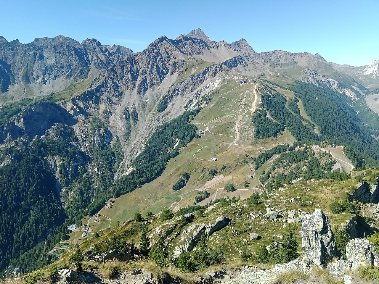
Courmayeur’s ski area has two principal sides, Chécrouit and Val Vény, facing the Mont Blanc landscape. Its appeal is not limited to difficult skiing: the resort provides ski schools and equipment hire alongside mountain restaurants. Use the piste map to choose terrain for your ability rather than treating the resort’s reputation as a description of every run.
Take care with headline distances. The official destination website combines groomed slopes and off-piste terrain in one advertised total; that is not the same measure as kilometres of prepared pistes alone. The map and current piste report are more informative when deciding what you can actually ski.
Our default point is at 1,205 m. It describes a lower location, while much of a ski day takes place above it. Check the chosen elevation before comparing a webcam with the forecast, and separate fresh snowfall from existing snow cover. For a mixed group planning both skiing and sightseeing, consult the particular facility’s operating information: a cable-car journey and a marked ski route are different activities with different access requirements.
Official sources: Courmayeur ski area · Courmayeur lifts and slopes. Reviewed 18 October 2026.
Courmayeur - Middle - Maison Vieille
ECMWF · Ejecución del modelo: Próxima actualización prevista:
Día Hora (UTC) Temp. (°C) Humedad (%) Viento (km/h) Viento (nudos) Viento (Bft) Dirección Precip. (mm) Nieve nueva (cm) Presión (hPa) Isoterma de 0 °C (m) Condiciones | Miércoles, 04/11 06:00 -2.7 84 3 2 1B E — — 1023 < 2136 Cloudy 76% cloud 09:00 -0.4 76 5 3 1B E 0.33 0.1 1023 < 2136 Overcast 95% cloud 12:00 0.6 71 6 3 2B E 0.62 0.2 1023 < 2136 Overcast 100% cloud 15:00 -0.1 79 6 3 2B E 0.47 0.1 1023 < 2136 Overcast 86% cloud 18:00 -1.6 86 5 3 1B E 0.48 0.1 1025 < 2136 Overcast 87% cloud 21:00 -1.8 84 5 3 1B E 0.30 0.1 1026 < 2136 Overcast 86% cloud Jueves, 05/11 00:00 -1.6 84 6 3 2B E 0.42 0.1 1026 < 2136 Overcast 94% cloud 03:00 -1.5 83 6 3 1B E 0.31 0.1 1026 < 2136 Overcast 95% cloud 06:00 -1.5 84 5 3 1B E 0.33 0.1 1026 < 2136 Overcast 85% cloud 09:00 1.3 75 6 3 1B E 0.22 0 1027 2202 Cloudy 74% cloud 12:00 2.9 69 5 3 1B E 0 0 1026 2493 Overcast 88% cloud 15:00 2.5 75 4 2 1B E 0 0 1025 2466 Cloudy 74% cloud 18:00 -0.6 87 3 1 1B E 0 0 1025 < 2136 Cloudy 64% cloud 21:00 -0.7 88 3 1 1B E 0.34 0.1 1025 < 2136 Overcast 94% cloud Viernes, 06/11 00:00 -0.4 90 3 2 1B E 0.07 0 1024 < 2136 Overcast 99% cloud 03:00 -0.5 89 3 2 1B E 0.35 0.1 1023 < 2136 Overcast 99% cloud 06:00 -0.5 90 3 2 1B E 0.18 0 1022 < 2136 Overcast 99% cloud 09:00 0.8 90 2 1 1B E 1.1 0.3 1023 < 2136 Overcast 100% cloud 12:00 1.1 88 2 1 1B NE 2.5 0.8 1022 2156 Overcast 100% cloud 15:00 0.7 90 2 1 1B N 0.92 0.3 1021 < 2136 Overcast 96% cloud 18:00 -0.3 95 2 1 1B NW 2.3 0.7 1022 < 2136 Overcast 100% cloud 21:00 -0.6 93 2 1 1B W 3.5 1.4 1022 < 2136 Overcast 100% cloud Sábado, 07/11 00:00 -0.9 93 1 0 0B NW 2.6 0.8 1023 < 2136 Overcast 100% cloud 03:00 -1.1 92 1 1 0B NW 0.59 0.2 1022 < 2136 Overcast 100% cloud 06:00 -1.3 92 0 0 0B — 0.15 0 1023 < 2136 Overcast 100% cloud 09:00 -0.1 86 3 1 1B E 0 0 1023 < 2136 Overcast 90% cloud 12:00 0.7 78 3 1 1B E 0 0 1022 < 2136 Overcast 90% cloud 15:00 0.1 84 2 1 1B NE 0.12 0 1022 < 2136 Overcast 94% cloud 18:00 -2.2 89 1 0 0B N 0.22 0 1024 < 2136 Overcast 81% cloud 21:00 -3.3 88 0 0 0B — 0.07 0.1 1025 < 2136 Overcast 84% cloud Domingo, 08/11 00:00 -5.1 83 1 1 0B W 0.07 0.1 1025 < 2136 Cloudy 69% cloud 03:00 -5.6 74 1 1 0B W 0 0 1025 < 2136 Partly cloudy 43% cloud 06:00 -6.3 69 1 0 0B W 0 0 1024 < 2136 Partly cloudy 27% cloud 09:00 -0.9 54 1 0 0B N 0 0 1025 < 2136 Clear 18% cloud 12:00 2.2 41 1 1 1B NW 0 0 1023 2300 Clear 1% cloud 15:00 1.1 48 1 1 1B N 0 0 1022 2157 Partly cloudy 27% cloud 18:00 -0.7 74 1 0 0B E 0.07 0 1022 < 2136 Overcast 93% cloud 21:00 0.2 81 0 0 0B — 0.04 0 1022 < 2136 Overcast 100% cloud Lunes, 09/11 00:00 0.4 84 1 0 0B NE 0.07 0 1022 < 2136 Overcast 99% cloud 03:00 -1 87 0 0 0B NE 0 0 1021 < 2136 Overcast 93% cloud 06:00 -2.1 88 0 0 0B NE 0 0 1021 < 2136 Overcast 94% cloud 09:00 2.1 80 3 1 1B NE 0.07 0 1021 2449 Overcast 100% cloud 12:00 2.6 78 3 2 1B E 0.21 0 1021 2596 Overcast 100% cloud 15:00 2.5 80 3 2 1B E 0 0 1019 2659 Overcast 100% cloud 18:00 1.6 85 3 2 1B E 0.23 0 1019 2492 Overcast 100% cloud 21:00 1.2 87 2 1 1B E 0 0 1019 2775 Overcast 98% cloud Martes, 10/11 00:00 1.1 88 2 1 1B NE 0 0 1017 3071 Overcast 100% cloud 03:00 0.5 90 2 1 1B E 0 0 1015 2475 Overcast 99% cloud 06:00 1.8 90 3 1 1B NE 3.0 0 1015 2939 Overcast 100% cloud |
|---|
Forecast notes
Forecast table times: UTC.
Coordinates: 45.7909197°N, 6.9333137°E · Requested elevation: 1958 m. Model terrain: 2134 m. Terrain and 1000/925/850/700 hPa profiles are used for height estimates.
Outside the available profile, temperature uses an estimated 5.5°C/km height correction; wind retains the nearest available model-level value. Humidity is estimated with adjusted pressure and temperature.
These are altitude estimates, not a simulation of local mountain terrain. Precipitation, cloud and sea-level pressure use horizontal interpolation only.
Precipitation includes rain and snow water equivalent: preceding 3 hours through day 6, then 6 hours (see cell tooltip). Snow (cm) estimates fresh snowfall from precipitation and temperature using the GFS conversion; it is not snow depth on the ground. Freezing (m) uses additional 600/500 hPa temperatures when available and estimates the lowest resolved 0°C crossing above sea level. When all sampled levels are warm, the upper profile limit is shown (see tooltip). < marks an entirely cold sampled profile and its lower height limit. No extrapolation is used.
Source: ECMWF · CC BY 4.0 · Processed by Snow Report.
Courmayeur - Top - Arp
ECMWF · Ejecución del modelo: Próxima actualización prevista:
Día Hora local Temp. (°C) Humedad (%) Viento (km/h) Viento (nudos) Viento (Bft) Dirección Precip. (mm) Nieve nueva (cm) Presión (hPa) Isoterma de 0 °C (m) Condiciones | Miércoles, 04/11 07:00 -6.4 84 14 8 3B SE — — 1023 < 2140 Cloudy 78% cloud 10:00 -5.6 81 18 10 3B SE 0.33 0.3 1024 < 2140 Overcast 96% cloud 13:00 -5.1 81 20 11 4B E 0.64 0.6 1023 < 2140 Overcast 99% cloud 16:00 -5 83 21 11 4B SE 0.46 0.5 1023 < 2140 Overcast 88% cloud 19:00 -5 83 19 10 3B SE 0.48 0.5 1025 < 2140 Overcast 89% cloud 22:00 -4.7 81 20 11 4B SE 0.30 0.3 1026 < 2140 Overcast 88% cloud Jueves, 05/11 01:00 -4.3 83 22 12 4B SE 0.42 0.4 1026 < 2140 Overcast 94% cloud 04:00 -4.1 82 23 12 4B SE 0.30 0.3 1026 < 2140 Overcast 96% cloud 07:00 -4 83 21 11 4B SE 0.37 0.4 1026 < 2140 Overcast 86% cloud 10:00 -2.4 78 19 10 3B SE 0.22 0 1027 2202 Cloudy 75% cloud 13:00 -1.5 76 15 8 3B SE 0 0 1026 2489 Overcast 88% cloud 16:00 -1.4 80 14 7 3B SE 0 0 1025 2464 Cloudy 75% cloud 19:00 -2.3 87 14 8 3B SE 0 0 1025 < 2140 Cloudy 62% cloud 22:00 -2.6 91 16 9 3B SE 0.42 0.1 1025 < 2140 Overcast 95% cloud Viernes, 06/11 01:00 -2.5 90 16 9 3B SE 0.07 0 1024 < 2140 Overcast 99% cloud 04:00 -2.3 89 16 9 3B SE 0.42 0.1 1023 < 2140 Overcast 99% cloud 07:00 -2.9 94 17 9 3B SE 0.19 0.2 1022 < 2140 Overcast 99% cloud 10:00 -2.9 97 13 7 3B SE 1.1 1.1 1023 < 2140 Overcast 100% cloud 13:00 -2.8 95 7 4 2B SE 2.5 0.8 1022 2162 Overcast 100% cloud 16:00 -3.4 97 4 2 1B E 0.95 0.9 1021 < 2140 Overcast 96% cloud 19:00 -4.2 98 4 2 1B N 2.5 1.9 1022 < 2140 Overcast 100% cloud 22:00 -4.7 99 5 3 1B N 3.8 2.9 1022 < 2140 Overcast 100% cloud Sábado, 07/11 01:00 -5 97 6 3 2B NE 2.7 2.1 1023 < 2140 Overcast 100% cloud 04:00 -5.3 97 4 2 1B NE 0.74 0.7 1022 < 2140 Overcast 100% cloud 07:00 -5.6 94 3 2 1B E 0.16 0.2 1023 < 2140 Overcast 100% cloud 10:00 -4.7 79 6 3 2B SE 0 0 1023 < 2140 Overcast 90% cloud 13:00 -4.7 86 7 4 2B S 0 0 1022 < 2140 Overcast 91% cloud 16:00 -5.1 92 7 4 2B S 0.12 0.1 1022 < 2140 Overcast 96% cloud 19:00 -5.7 71 8 4 2B SW 0.22 0.2 1024 < 2140 Overcast 83% cloud 22:00 -5.9 62 7 4 2B SW 0.07 0.1 1025 < 2140 Overcast 84% cloud Domingo, 08/11 01:00 -6.6 59 7 4 2B SW 0.07 0.1 1025 < 2140 Cloudy 67% cloud 04:00 -6.6 50 10 5 2B SW 0 0 1025 < 2140 Partly cloudy 42% cloud 07:00 -6.4 43 11 6 2B SW 0 0 1024 < 2140 Partly cloudy 26% cloud 10:00 -4.6 40 14 7 3B W 0 0 1025 < 2140 Clear 18% cloud 13:00 -3.5 42 17 9 3B SW 0 0 1023 2288 Clear 1% cloud 16:00 -3.3 69 18 10 3B SW 0 0 1022 < 2140 Partly cloudy 30% cloud 19:00 -3.2 89 19 10 3B SW 0.07 0.1 1022 < 2140 Overcast 91% cloud 22:00 -2.6 91 20 11 3B SW 0.04 0 1022 < 2140 Overcast 100% cloud Lunes, 09/11 01:00 -2.4 93 18 10 3B SW 0.07 0 1022 < 2140 Overcast 99% cloud 04:00 -3 90 20 11 3B SW 0 0 1021 < 2140 Overcast 95% cloud 07:00 -3.1 91 21 11 4B SW 0 0 1021 < 2140 Overcast 95% cloud 10:00 -1.1 91 22 12 4B SW 0.07 0 1021 2411 Overcast 100% cloud 13:00 -0.6 91 21 11 4B SW 0.20 0 1021 2572 Overcast 100% cloud 16:00 -0.3 86 18 10 3B SW 0 0 1019 2637 Overcast 100% cloud 19:00 -0.5 92 19 10 3B SW 0.21 0 1019 2443 Overcast 100% cloud 22:00 -0.1 94 19 10 3B SW 0 0 1019 2445 Overcast 98% cloud Martes, 10/11 01:00 0.2 95 19 10 3B SW 0 0 1017 3071 Overcast 100% cloud 04:00 0.3 90 21 11 4B SW 0 0 1015 2533 Overcast 100% cloud 07:00 0.2 97 19 10 3B SW 3.0 1.2 1015 2949 Overcast 100% cloud |
|---|
Forecast notes
Forecast table times: Europe/Rome.
Coordinates: 45.7706665°N, 6.9156433°E · Requested elevation: 2755 m. Model terrain: 2137 m. Terrain and 1000/925/850/700 hPa profiles are used for height estimates.
These are altitude estimates, not a simulation of local mountain terrain. Precipitation, cloud and sea-level pressure use horizontal interpolation only.
Precipitation includes rain and snow water equivalent: preceding 3 hours through day 6, then 6 hours (see cell tooltip). Snow (cm) estimates fresh snowfall from precipitation and temperature using the GFS conversion; it is not snow depth on the ground. Freezing (m) uses additional 600/500 hPa temperatures when available and estimates the lowest resolved 0°C crossing above sea level. When all sampled levels are warm, the upper profile limit is shown (see tooltip). < marks an entirely cold sampled profile and its lower height limit. No extrapolation is used.