Προγνώσεις για χιονοδρομικά σε όλο τον κόσμο

Περισσότερα
Χρωματική κλίμακα Θερμοκρασία · Άνεμος · Βροχή · Χιόνι
Κάθε χρώμα ξεκινά από την τιμή που αναγράφεται. Τα χρώματα ανέμου αντιστοιχούν και στις τρεις μονάδες. Οι τιμές χωρίς υετό παραμένουν ουδέτερες. Τα χρώματα περιγράφουν τις τιμές και δεν αποτελούν επίσημες προειδοποιήσεις.
Courmayeur - βάση
ECMWF · Εκτέλεση μοντέλου: Αναμενόμενη επόμενη ενημέρωση:
Ημέρα Τοπική ώρα Θερμ. (°C) Υγρασία (%) Άνεμος (km/h) Άνεμος (κόμβοι) Άνεμος (Bft) Διεύθυνση Υετός (mm) Νέο χιόνι (cm) Πίεση (hPa) Σημείο παγοποίησης (m) Συνθήκες | Τετάρτη, 04/11 07:00 1.4 69 3 2 1B NE — — 1023 < 2161 Overcast 84% cloud  10:00 3.4 63 5 3 1B NE 0.40 0 1024 < 2161 Overcast 97% cloud 13:00 4.4 60 6 3 2B E 0.71 0 1024 < 2161 Overcast 100% cloud 16:00 3.7 66 6 3 1B E 0.55 0 1024 < 2161 Overcast 91% cloud 19:00 2.4 71 5 2 1B E 0.57 0 1025 < 2161 Overcast 91% cloud 22:00 2.2 69 4 2 1B E 0.37 0 1027 < 2161 Overcast 91% cloud Πέμπτη, 05/11 01:00 2.4 70 5 3 1B E 0.49 0 1027 < 2161 Overcast 96% cloud 04:00 2.4 69 5 3 1B E 0.39 0 1027 < 2161 Overcast 97% cloud 07:00 2.5 69 4 2 1B E 0.33 0 1027 < 2161 Overcast 91% cloud 10:00 5 64 5 3 1B E 0.28 0 1028 < 2161 Overcast 83% cloud 13:00 6.5 59 5 3 1B E 0 0 1027 2414 Overcast 91% cloud 16:00 6.3 63 3 2 1B E 0 0 1025 2392 Cloudy 79% cloud  19:00 3.4 71 2 1 1B E 0 0 1025 < 2161 Cloudy 72% cloud 22:00 3.4 72 2 1 1B NE 0.22 0 1026 < 2161 Overcast 97% cloud Παρασκευή, 06/11 01:00 3.7 73 3 1 1B NE 0.09 0 1024 < 2161 Overcast 99% cloud 04:00 3.6 73 3 1 1B E 0.27 0 1023 < 2161 Overcast 99% cloud 07:00 3.6 74 3 2 1B E 0.20 0 1022 < 2161 Overcast 99% cloud 10:00 4.9 73 3 1 1B E 1.0 0 1023 < 2161 Overcast 100% cloud 13:00 5.1 72 2 1 1B NE 2.7 0 1022 < 2161 Overcast 100% cloud 16:00 4.8 73 2 1 1B N 0.84 0 1021 < 2161 Overcast 95% cloud 19:00 3.8 77 2 1 1B NW 2.1 0 1022 < 2161 Overcast 100% cloud 22:00 3.7 75 2 1 1B W 3.3 0 1022 < 2161 Overcast 100% cloud Σάββατο, 07/11 01:00 3.4 75 1 0 0B NW 2.6 0 1023 < 2161 Overcast 100% cloud 04:00 3.2 75 1 1 0B NW 0.39 0 1022 < 2161 Overcast 100% cloud 07:00 2.9 74 0 0 0B NW 0.14 0 1023 < 2161 Overcast 100% cloud 10:00 3.9 71 3 2 1B E 0 0 1023 < 2161 Overcast 91% cloud 13:00 4.6 64 3 2 1B NE 0 0 1023 < 2161 Overcast 89% cloud 16:00 4.1 68 2 1 1B NE 0.12 0 1023 < 2161 Overcast 95% cloud 19:00 1.9 72 1 1 0B N 0.28 0 1024 < 2161 Overcast 88% cloud 22:00 1 71 1 0 0B W 0.09 0 1025 < 2161 Overcast 90% cloud Κυριακή, 08/11 01:00 -0.8 67 2 1 1B W 0.09 0 1025 < 2161 Cloudy 77% cloud 04:00 -1.5 60 2 1 1B W 0 0 1025 < 2161 Partly cloudy 49% cloud  07:00 -2.2 57 1 1 1B W 0 0 1025 < 2161 Partly cloudy 32% cloud 10:00 3.1 45 1 1 0B N 0 0 1025 < 2161 Partly cloudy 22% cloud 13:00 6.2 34 2 1 1B NW 0 0 1023 2294 Clear 1% cloud  16:00 5.2 39 2 1 1B NW 0 0 1022 < 2161 Partly cloudy 23% cloud 19:00 3.3 60 0 0 0B W 0.09 0 1022 < 2161 Overcast 95% cloud 22:00 4.2 66 1 0 0B NW 0.03 0 1022 < 2161 Overcast 100% cloud Δευτέρα, 09/11 01:00 4.4 69 1 1 0B NW 0.09 0 1022 < 2161 Overcast 100% cloud 04:00 3.1 70 1 0 0B NW 0 0 1021 < 2161 Overcast 93% cloud 07:00 1.9 71 1 0 0B NW 0 0 1021 < 2161 Overcast 94% cloud 10:00 6 66 2 1 1B NE 0.09 0 1022 2393 Overcast 100% cloud 13:00 6.4 65 3 1 1B NE 0.23 0 1021 2532 Overcast 100% cloud 16:00 6.3 66 2 1 1B NE 0 0 1019 2590 Overcast 100% cloud 19:00 5.6 70 2 1 1B NE 0.24 0 1019 2373 Overcast 100% cloud 22:00 5.2 72 2 1 1B NE 0 0 1019 < 2161 Overcast 99% cloud Τρίτη, 10/11 01:00 5 72 2 1 1B NE 0 0 1018 2595 Overcast 100% cloud 04:00 4.4 73 1 1 1B NE 0 0 1016 2632 Overcast 99% cloud 07:00 5.8 74 2 1 1B NE 2.9 0 1016 2817 Overcast 100% cloud |
|---|
Forecast notes
Forecast table times: Europe/Rome.
Coordinates: 45.78500315°N, 6.9708252°E · Requested elevation: 1205 m. Model terrain: 2159 m. Terrain and 1000/925/850/700 hPa profiles are used for height estimates.
Outside the available profile, temperature uses an estimated 5.5°C/km height correction; wind retains the nearest available model-level value. Humidity is estimated with adjusted pressure and temperature.
These are altitude estimates, not a simulation of local mountain terrain. Precipitation, cloud and sea-level pressure use horizontal interpolation only.
Precipitation includes rain and snow water equivalent: preceding 3 hours through day 6, then 6 hours (see cell tooltip). Snow (cm) estimates fresh snowfall from precipitation and temperature using the GFS conversion; it is not snow depth on the ground. Freezing (m) uses additional 600/500 hPa temperatures when available and estimates the lowest resolved 0°C crossing above sea level. When all sampled levels are warm, the upper profile limit is shown (see tooltip). < marks an entirely cold sampled profile and its lower height limit. No extrapolation is used.
Source: ECMWF · CC BY 4.0 · Processed by Snow Report.
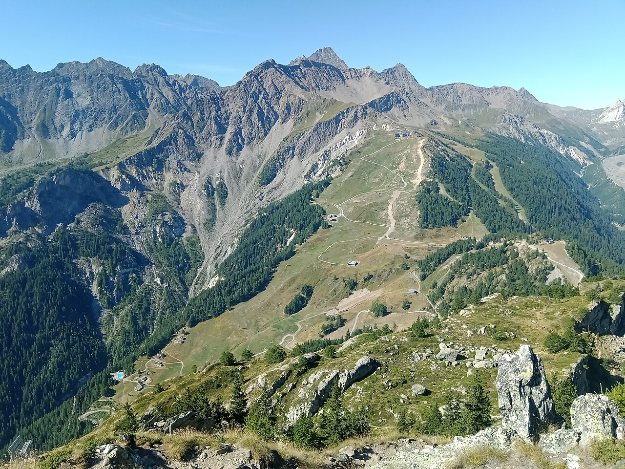
Το χιονοδρομικό πεδίο του Courmayeur απλώνεται σε δύο κύριες πλευρές, Chécrouit και Val Vény, με θέα στον ορεινό όγκο του Mont Blanc. Δεν αφορά μόνο απαιτητικό σκι: υπάρχουν σχολές, ενοικίαση εξοπλισμού και εστιατόρια στο βουνό. Επιλέξτε πίστες από τον επίσημο χάρτη σύμφωνα με το επίπεδό σας, χωρίς να θεωρείτε ότι η φήμη του προορισμού περιγράφει κάθε διαδρομή.
Χρειάζεται προσοχή στα συνολικά χιλιόμετρα. Η επίσημη ιστοσελίδα του προορισμού προσθέτει πίστες και πεδία εκτός πίστας στο ίδιο διαφημιζόμενο άθροισμα. Αυτό δεν ισοδυναμεί με χιλιόμετρα αποκλειστικά διαμορφωμένων πιστών. Ο χάρτης και η τρέχουσα ενημέρωση δείχνουν καλύτερα πού μπορείτε πράγματι να κάνετε σκι.
Το προεπιλεγμένο σημείο μας βρίσκεται στα 1.205 μ., χαμηλότερα από μεγάλο μέρος της χιονοδρομικής δραστηριότητας. Ελέγξτε το υψόμετρο όταν συγκρίνετε κάμερα και πρόγνωση και ξεχωρίστε το νέο χιόνι από την υπάρχουσα χιονοκάλυψη. Αν η παρέα συνδυάζει σκι και περιήγηση, δείτε την ενημέρωση της συγκεκριμένης εγκατάστασης: μια διαδρομή με τελεφερίκ δεν είναι το ίδιο με μια σηματοδοτημένη χιονοδρομική διαδρομή.
Επίσημες πηγές: Courmayeur ski area · Courmayeur lifts and slopes. Έλεγχος πληροφοριών: 18 Οκτωβρίου 2026.
Courmayeur - Middle - Maison Vieille
ECMWF · Εκτέλεση μοντέλου: Αναμενόμενη επόμενη ενημέρωση:
Ημέρα Τοπική ώρα Θερμ. (°C) Υγρασία (%) Άνεμος (km/h) Άνεμος (κόμβοι) Άνεμος (Bft) Διεύθυνση Υετός (mm) Νέο χιόνι (cm) Πίεση (hPa) Σημείο παγοποίησης (m) Συνθήκες | Τετάρτη, 04/11 07:00 -2.7 84 3 2 1B E — — 1023 < 2136 Cloudy 76% cloud 10:00 -0.4 76 5 3 1B E 0.33 0.1 1023 < 2136 Overcast 95% cloud 13:00 0.6 71 6 3 2B E 0.62 0.2 1023 < 2136 Overcast 100% cloud 16:00 -0.1 79 6 3 2B E 0.47 0.1 1023 < 2136 Overcast 86% cloud 19:00 -1.6 86 5 3 1B E 0.48 0.1 1025 < 2136 Overcast 87% cloud 22:00 -1.8 84 5 3 1B E 0.30 0.1 1026 < 2136 Overcast 86% cloud Πέμπτη, 05/11 01:00 -1.6 84 6 3 2B E 0.42 0.1 1026 < 2136 Overcast 94% cloud 04:00 -1.5 83 6 3 1B E 0.31 0.1 1026 < 2136 Overcast 95% cloud 07:00 -1.5 84 5 3 1B E 0.33 0.1 1026 < 2136 Overcast 85% cloud 10:00 1.3 75 6 3 1B E 0.22 0 1027 2202 Cloudy 74% cloud 13:00 2.9 69 5 3 1B E 0 0 1026 2493 Overcast 88% cloud 16:00 2.5 75 4 2 1B E 0 0 1025 2466 Cloudy 74% cloud 19:00 -0.6 87 3 1 1B E 0 0 1025 < 2136 Cloudy 64% cloud 22:00 -0.7 88 3 1 1B E 0.34 0.1 1025 < 2136 Overcast 94% cloud Παρασκευή, 06/11 01:00 -0.4 90 3 2 1B E 0.07 0 1024 < 2136 Overcast 99% cloud 04:00 -0.5 89 3 2 1B E 0.35 0.1 1023 < 2136 Overcast 99% cloud 07:00 -0.5 90 3 2 1B E 0.18 0 1022 < 2136 Overcast 99% cloud 10:00 0.8 90 2 1 1B E 1.1 0.3 1023 < 2136 Overcast 100% cloud 13:00 1.1 88 2 1 1B NE 2.5 0.8 1022 2156 Overcast 100% cloud 16:00 0.7 90 2 1 1B N 0.92 0.3 1021 < 2136 Overcast 96% cloud 19:00 -0.3 95 2 1 1B NW 2.3 0.7 1022 < 2136 Overcast 100% cloud 22:00 -0.6 93 2 1 1B W 3.5 1.4 1022 < 2136 Overcast 100% cloud Σάββατο, 07/11 01:00 -0.9 93 1 0 0B NW 2.6 0.8 1023 < 2136 Overcast 100% cloud 04:00 -1.1 92 1 1 0B NW 0.59 0.2 1022 < 2136 Overcast 100% cloud 07:00 -1.3 92 0 0 0B — 0.15 0 1023 < 2136 Overcast 100% cloud 10:00 -0.1 86 3 1 1B E 0 0 1023 < 2136 Overcast 90% cloud 13:00 0.7 78 3 1 1B E 0 0 1022 < 2136 Overcast 90% cloud 16:00 0.1 84 2 1 1B NE 0.12 0 1022 < 2136 Overcast 94% cloud 19:00 -2.2 89 1 0 0B N 0.22 0 1024 < 2136 Overcast 81% cloud 22:00 -3.3 88 0 0 0B — 0.07 0.1 1025 < 2136 Overcast 84% cloud Κυριακή, 08/11 01:00 -5.1 83 1 1 0B W 0.07 0.1 1025 < 2136 Cloudy 69% cloud 04:00 -5.6 74 1 1 0B W 0 0 1025 < 2136 Partly cloudy 43% cloud 07:00 -6.3 69 1 0 0B W 0 0 1024 < 2136 Partly cloudy 27% cloud 10:00 -0.9 54 1 0 0B N 0 0 1025 < 2136 Clear 18% cloud 13:00 2.2 41 1 1 1B NW 0 0 1023 2300 Clear 1% cloud 16:00 1.1 48 1 1 1B N 0 0 1022 2157 Partly cloudy 27% cloud 19:00 -0.7 74 1 0 0B E 0.07 0 1022 < 2136 Overcast 93% cloud 22:00 0.2 81 0 0 0B — 0.04 0 1022 < 2136 Overcast 100% cloud Δευτέρα, 09/11 01:00 0.4 84 1 0 0B NE 0.07 0 1022 < 2136 Overcast 99% cloud 04:00 -1 87 0 0 0B NE 0 0 1021 < 2136 Overcast 93% cloud 07:00 -2.1 88 0 0 0B NE 0 0 1021 < 2136 Overcast 94% cloud 10:00 2.1 80 3 1 1B NE 0.07 0 1021 2449 Overcast 100% cloud 13:00 2.6 78 3 2 1B E 0.21 0 1021 2596 Overcast 100% cloud 16:00 2.5 80 3 2 1B E 0 0 1019 2659 Overcast 100% cloud 19:00 1.6 85 3 2 1B E 0.23 0 1019 2492 Overcast 100% cloud 22:00 1.2 87 2 1 1B E 0 0 1019 2775 Overcast 98% cloud Τρίτη, 10/11 01:00 1.1 88 2 1 1B NE 0 0 1017 3071 Overcast 100% cloud 04:00 0.5 90 2 1 1B E 0 0 1015 2475 Overcast 99% cloud 07:00 1.8 90 3 1 1B NE 3.0 0 1015 2939 Overcast 100% cloud |
|---|
Forecast notes
Forecast table times: Europe/Rome.
Coordinates: 45.7909197°N, 6.9333137°E · Requested elevation: 1958 m. Model terrain: 2134 m. Terrain and 1000/925/850/700 hPa profiles are used for height estimates.
Outside the available profile, temperature uses an estimated 5.5°C/km height correction; wind retains the nearest available model-level value. Humidity is estimated with adjusted pressure and temperature.
These are altitude estimates, not a simulation of local mountain terrain. Precipitation, cloud and sea-level pressure use horizontal interpolation only.
Precipitation includes rain and snow water equivalent: preceding 3 hours through day 6, then 6 hours (see cell tooltip). Snow (cm) estimates fresh snowfall from precipitation and temperature using the GFS conversion; it is not snow depth on the ground. Freezing (m) uses additional 600/500 hPa temperatures when available and estimates the lowest resolved 0°C crossing above sea level. When all sampled levels are warm, the upper profile limit is shown (see tooltip). < marks an entirely cold sampled profile and its lower height limit. No extrapolation is used.
Source: ECMWF · CC BY 4.0 · Processed by Snow Report.
Courmayeur - Top - Arp
ECMWF · Εκτέλεση μοντέλου: Αναμενόμενη επόμενη ενημέρωση:
Ημέρα Τοπική ώρα Θερμ. (°C) Υγρασία (%) Άνεμος (km/h) Άνεμος (κόμβοι) Άνεμος (Bft) Διεύθυνση Υετός (mm) Νέο χιόνι (cm) Πίεση (hPa) Σημείο παγοποίησης (m) Συνθήκες | Τετάρτη, 04/11 07:00 -6.4 84 14 8 3B SE — — 1023 < 2140 Cloudy 78% cloud 10:00 -5.6 81 18 10 3B SE 0.33 0.3 1024 < 2140 Overcast 96% cloud 13:00 -5.1 81 20 11 4B E 0.64 0.6 1023 < 2140 Overcast 99% cloud 16:00 -5 83 21 11 4B SE 0.46 0.5 1023 < 2140 Overcast 88% cloud 19:00 -5 83 19 10 3B SE 0.48 0.5 1025 < 2140 Overcast 89% cloud 22:00 -4.7 81 20 11 4B SE 0.30 0.3 1026 < 2140 Overcast 88% cloud Πέμπτη, 05/11 01:00 -4.3 83 22 12 4B SE 0.42 0.4 1026 < 2140 Overcast 94% cloud 04:00 -4.1 82 23 12 4B SE 0.30 0.3 1026 < 2140 Overcast 96% cloud 07:00 -4 83 21 11 4B SE 0.37 0.4 1026 < 2140 Overcast 86% cloud 10:00 -2.4 78 19 10 3B SE 0.22 0 1027 2202 Cloudy 75% cloud 13:00 -1.5 76 15 8 3B SE 0 0 1026 2489 Overcast 88% cloud 16:00 -1.4 80 14 7 3B SE 0 0 1025 2464 Cloudy 75% cloud 19:00 -2.3 87 14 8 3B SE 0 0 1025 < 2140 Cloudy 62% cloud 22:00 -2.6 91 16 9 3B SE 0.42 0.1 1025 < 2140 Overcast 95% cloud Παρασκευή, 06/11 01:00 -2.5 90 16 9 3B SE 0.07 0 1024 < 2140 Overcast 99% cloud 04:00 -2.3 89 16 9 3B SE 0.42 0.1 1023 < 2140 Overcast 99% cloud 07:00 -2.9 94 17 9 3B SE 0.19 0.2 1022 < 2140 Overcast 99% cloud 10:00 -2.9 97 13 7 3B SE 1.1 1.1 1023 < 2140 Overcast 100% cloud 13:00 -2.8 95 7 4 2B SE 2.5 0.8 1022 2162 Overcast 100% cloud 16:00 -3.4 97 4 2 1B E 0.95 0.9 1021 < 2140 Overcast 96% cloud 19:00 -4.2 98 4 2 1B N 2.5 1.9 1022 < 2140 Overcast 100% cloud 22:00 -4.7 99 5 3 1B N 3.8 2.9 1022 < 2140 Overcast 100% cloud Σάββατο, 07/11 01:00 -5 97 6 3 2B NE 2.7 2.1 1023 < 2140 Overcast 100% cloud 04:00 -5.3 97 4 2 1B NE 0.74 0.7 1022 < 2140 Overcast 100% cloud 07:00 -5.6 94 3 2 1B E 0.16 0.2 1023 < 2140 Overcast 100% cloud 10:00 -4.7 79 6 3 2B SE 0 0 1023 < 2140 Overcast 90% cloud 13:00 -4.7 86 7 4 2B S 0 0 1022 < 2140 Overcast 91% cloud 16:00 -5.1 92 7 4 2B S 0.12 0.1 1022 < 2140 Overcast 96% cloud 19:00 -5.7 71 8 4 2B SW 0.22 0.2 1024 < 2140 Overcast 83% cloud 22:00 -5.9 62 7 4 2B SW 0.07 0.1 1025 < 2140 Overcast 84% cloud Κυριακή, 08/11 01:00 -6.6 59 7 4 2B SW 0.07 0.1 1025 < 2140 Cloudy 67% cloud 04:00 -6.6 50 10 5 2B SW 0 0 1025 < 2140 Partly cloudy 42% cloud 07:00 -6.4 43 11 6 2B SW 0 0 1024 < 2140 Partly cloudy 26% cloud 10:00 -4.6 40 14 7 3B W 0 0 1025 < 2140 Clear 18% cloud 13:00 -3.5 42 17 9 3B SW 0 0 1023 2288 Clear 1% cloud 16:00 -3.3 69 18 10 3B SW 0 0 1022 < 2140 Partly cloudy 30% cloud 19:00 -3.2 89 19 10 3B SW 0.07 0.1 1022 < 2140 Overcast 91% cloud 22:00 -2.6 91 20 11 3B SW 0.04 0 1022 < 2140 Overcast 100% cloud Δευτέρα, 09/11 01:00 -2.4 93 18 10 3B SW 0.07 0 1022 < 2140 Overcast 99% cloud 04:00 -3 90 20 11 3B SW 0 0 1021 < 2140 Overcast 95% cloud 07:00 -3.1 91 21 11 4B SW 0 0 1021 < 2140 Overcast 95% cloud 10:00 -1.1 91 22 12 4B SW 0.07 0 1021 2411 Overcast 100% cloud 13:00 -0.6 91 21 11 4B SW 0.20 0 1021 2572 Overcast 100% cloud 16:00 -0.3 86 18 10 3B SW 0 0 1019 2637 Overcast 100% cloud 19:00 -0.5 92 19 10 3B SW 0.21 0 1019 2443 Overcast 100% cloud 22:00 -0.1 94 19 10 3B SW 0 0 1019 2445 Overcast 98% cloud Τρίτη, 10/11 01:00 0.2 95 19 10 3B SW 0 0 1017 3071 Overcast 100% cloud 04:00 0.3 90 21 11 4B SW 0 0 1015 2533 Overcast 100% cloud 07:00 0.2 97 19 10 3B SW 3.0 1.2 1015 2949 Overcast 100% cloud |
|---|
Forecast notes
Forecast table times: Europe/Rome.
Coordinates: 45.7706665°N, 6.9156433°E · Requested elevation: 2755 m. Model terrain: 2137 m. Terrain and 1000/925/850/700 hPa profiles are used for height estimates.
These are altitude estimates, not a simulation of local mountain terrain. Precipitation, cloud and sea-level pressure use horizontal interpolation only.
Precipitation includes rain and snow water equivalent: preceding 3 hours through day 6, then 6 hours (see cell tooltip). Snow (cm) estimates fresh snowfall from precipitation and temperature using the GFS conversion; it is not snow depth on the ground. Freezing (m) uses additional 600/500 hPa temperatures when available and estimates the lowest resolved 0°C crossing above sea level. When all sampled levels are warm, the upper profile limit is shown (see tooltip). < marks an entirely cold sampled profile and its lower height limit. No extrapolation is used.