SNOWREPORT
METEOCAM
Previsioni per le stazioni sciistiche di tutto il mondo
Modelli meteo GFS, ECMWF e ICON
Previsioni fino a 16 giorni
2,272 stazioni sciistiche Ultima stazione aggiunta: Moose Mountain Ski Resort ↗
125 webcam sulla neve Ultima webcam aggiunta: Skeetawk ↗
Esperienza nel meteo di montagna dal 1996

Altro
Memorizza località, altitudine, modello e visualizzazione in questo browser.
Legenda dei colori Temperatura · Vento · Pioggia · Neve
Temperatura °C< −10 / −10 / 0 / 10 / 20 / 30+
Vento km/h< 10 / 10 / 29 / 50 / 75+
Pioggia mm< 1 / 1 / 3 / 10 / 20+
Neve cm< 1 / 1 / 5 / 10 / 20+
Ogni colore inizia dal valore indicato. I colori del vento corrispondono nelle tre unità di misura. Le celle senza precipitazioni restano neutre. I colori descrivono i valori visualizzati, non avvisi meteo ufficiali.
Preparazione dei grafici…
Orari e valori corrispondono alla previsione dettagliata. Tocca un valore o passaci sopra per i dettagli. Scorri orizzontalmente ogni grafico per i giorni successivi. Pioggia / precipitazioni indica l’equivalente totale in acqua per intervallo, inclusa la neve; la nevicata indica la neve fresca per intervallo, non l’altezza del manto nevoso.
Confronto dei modelli GFS ed ECMWF. Ogni modello mantiene i propri orari e il proprio orizzonte di previsione. Le quantità di precipitazioni e neve si riferiscono ai rispettivi intervalli, che possono differire tra i modelli.
Valori previsti e note sul modello
Zermatt - base 1619 m
ECMWF · Elaborazione del modello: Prossimo aggiornamento previsto:
Giorno Ora (UTC) Temp. (°C) Umidità (%) Vento (km/h) Vento (nodi) Vento (Bft) Direzione Precip. (mm) Neve (cm) Pressione (hPa) Zero termico (m) Condizioni | Mercoledì, 04/11 06:00 -0.9 64 4 2 1B S — — 1024 < 2919 Overcast 98% cloud  09:00 0.3 65 5 3 1B SE 0.11 0 1025 < 2919 Overcast 98% cloud 12:00 0.8 65 6 3 1B SE 0.23 0 1025 < 2919 Overcast 100% cloud 15:00 0.7 64 6 3 2B SE 0.62 0.2 1025 < 2919 Overcast 97% cloud 18:00 0 65 6 3 1B S 0.17 0 1027 < 2919 Overcast 97% cloud 21:00 -0.8 64 4 2 1B SE 0.12 0 1029 < 2919 Overcast 97% cloud Giovedì, 05/11 00:00 -0.5 64 5 3 1B SE 0.11 0 1028 < 2919 Overcast 97% cloud 03:00 -0.4 64 5 3 1B SE 0.11 0 1028 < 2919 Overcast 97% cloud 06:00 -0.3 64 3 2 1B S 0 0 1027 < 2919 Overcast 95% cloud 09:00 2.2 66 5 3 1B S 0.11 0 1027 < 2919 Overcast 98% cloud 12:00 3.8 67 5 3 1B S 0 0 1026 < 2919 Overcast 96% cloud 15:00 4.2 65 4 2 1B S 0 0 1025 < 2919 Cloudy 60% cloud  18:00 1.3 65 2 1 1B S 0.34 0 1024 < 2919 Overcast 98% cloud 21:00 1.5 65 2 1 1B S 1.3 0 1024 < 2919 Overcast 98% cloud Venerdì, 06/11 00:00 1.9 67 3 2 1B SE 0.56 0 1023 < 2919 Overcast 100% cloud 03:00 2.1 67 3 1 1B SE 1.9 0 1021 < 2919 Overcast 100% cloud 06:00 2.8 68 4 2 1B SE 0.79 0 1021 < 2919 Overcast 99% cloud 09:00 3.5 69 4 2 1B SE 0.34 0 1022 < 2919 Overcast 98% cloud 12:00 3.9 66 3 2 1B SE 0.46 0 1021 < 2919 Overcast 100% cloud 15:00 4 65 3 1 1B SE 1.8 0 1019 < 2919 Overcast 100% cloud 18:00 2.8 66 2 1 1B E 2.4 0 1020 < 2919 Overcast 100% cloud 21:00 2.5 66 2 1 1B E 0.75 0 1020 < 2919 Overcast 100% cloud Sabato, 07/11 00:00 2 67 1 1 1B NE 0.75 0 1021 < 2919 Overcast 100% cloud 03:00 1.4 68 1 1 1B N 0.14 0 1021 < 2919 Overcast 100% cloud 06:00 1.2 66 1 1 0B NE 0.58 0 1022 < 2919 Overcast 100% cloud 09:00 1.4 67 2 1 1B SE 0.91 0 1023 < 2919 Overcast 100% cloud 12:00 1.9 63 4 2 1B S 0.57 0 1022 < 2919 Overcast 99% cloud 15:00 1.4 66 4 2 1B S 1.5 0 1022 < 2919 Overcast 99% cloud 18:00 0.7 65 2 1 1B S 0.91 0.3 1024 < 2919 Overcast 99% cloud 21:00 0.2 67 1 1 1B S 0.22 0 1024 < 2919 Overcast 96% cloud Domenica, 08/11 00:00 -0.9 65 0 0 0B NW 0 0 1026 < 2919 Overcast 93% cloud 03:00 -5.6 60 1 1 1B NW 0 0 1024 < 2919 Overcast 92% cloud 06:00 -9.3 56 1 1 1B NW 0 0 1024 < 2919 Partly cloudy 38% cloud  09:00 -3.8 47 1 0 0B NW 0 0 1024 < 2919 Clear 8% cloud  12:00 1.2 38 2 1 1B SW 0 0 1024 < 2919 Clear 4% cloud 15:00 -0.2 35 2 1 1B W 0 0 1023 < 2919 Clear 2% cloud 18:00 -2.9 31 1 1 1B W 0 0 1022 < 2919 Clear 16% cloud 21:00 -1.7 35 1 1 1B SW 0 0 1021 < 2919 Overcast 93% cloud Lunedì, 09/11 00:00 -0 51 1 1 1B SW 0.00 0 1021 < 2919 Overcast 93% cloud 03:00 -0.2 56 1 1 1B SW 0 0 1020 < 2919 Cloudy 58% cloud 06:00 -0.1 59 1 1 1B SW 0 0 1020 < 2919 Cloudy 80% cloud 09:00 2.6 56 3 2 1B SW 0 0 1020 < 2919 Cloudy 76% cloud 12:00 5.1 58 5 3 1B SW 0.11 0 1020 < 2919 Overcast 100% cloud 15:00 5.4 62 4 2 1B SW 0.13 0 1018 < 2919 Overcast 95% cloud 18:00 4.5 65 3 2 1B SW 0.11 0 1018 < 2919 Overcast 99% cloud 21:00 4.5 65 4 2 1B SW 0.11 0 1017 < 2919 Overcast 97% cloud Martedì, 10/11 00:00 3.3 68 4 2 1B SW 0 0 1016 < 2919 Overcast 100% cloud 03:00 4.1 68 3 2 1B SW 0 0 1014 < 2919 Overcast 100% cloud 06:00 5 69 4 2 1B S 0.13 0 1014 < 2919 Overcast 100% cloud |
|---|
Forecast notes
Forecast table times: UTC.
Coordinates: 46.01794609°N, 7.74673462°E · Requested elevation: 1619 m. Model terrain: 2917 m. Terrain and 1000/925/850/700 hPa profiles are used for height estimates.
Outside the available profile, temperature uses an estimated 5.5°C/km height correction; wind retains the nearest available model-level value. Humidity is estimated with adjusted pressure and temperature.
These are altitude estimates, not a simulation of local mountain terrain. Precipitation, cloud and sea-level pressure use horizontal interpolation only.
Precipitation includes rain and snow water equivalent: preceding 3 hours through day 6, then 6 hours (see cell tooltip). Snow (cm) estimates fresh snowfall from precipitation and temperature using the GFS conversion; it is not snow depth on the ground. Freezing (m) uses additional 600/500 hPa temperatures when available and estimates the lowest resolved 0°C crossing above sea level. When all sampled levels are warm, the upper profile limit is shown (see tooltip). < marks an entirely cold sampled profile and its lower height limit. No extrapolation is used.
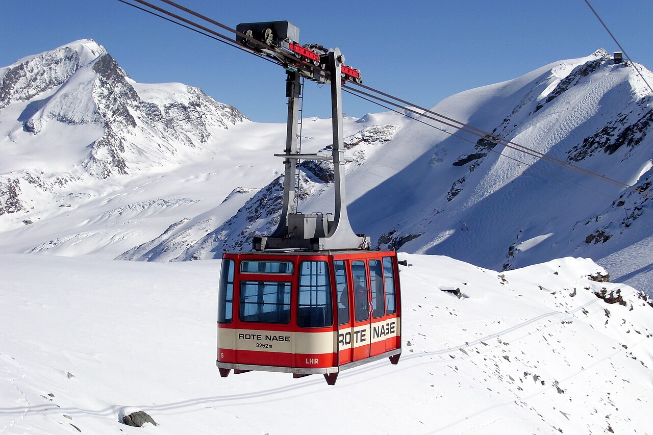
Zermatt is a car-free alpine village in Switzerland, beneath the distinctive pyramid of the Matterhorn. Its skiing forms part of the international Matterhorn Ski Paradise, linking the Swiss slopes with Breuil-Cervinia and Valtournenche in Italy. The operator advertises up to 360 km of pistes across the combined area; this is the full network, not a guarantee that every run or cross-border connection is open.
On the Swiss side, the principal sectors are Sunnegga–Rothorn, Gornergrat and Schwarzsee–Matterhorn Glacier Paradise. Together they provide contrasting mountain landscapes and a wide choice of routes. Sunnegga also has Wolli’s beginners’ park, making it useful for learners and families. A Zermatt-only ski pass and an international pass cover different areas, so check the territory included before planning a day across the border.
Matterhorn Glacier Paradise reaches 3,883 m and gives access to high-altitude glacier skiing. The glacier also supports summer skiing when conditions and operations permit, but the available terrain changes through the year. High elevation is an important feature of the destination, and conditions on the glacier can differ sharply from those in the village.
Visitors arriving by car normally leave their vehicle in Täsch and continue by shuttle train to Zermatt. The village’s car-free setting and mountain transport are central to the experience. Before setting out, check the forecast for your chosen elevation and the operator’s current lift, piste and international-connection status.
Official information: Ski area · Getting to Zermatt.
Resort cameras
Preparazione dei grafici…
Orari e valori corrispondono alla previsione dettagliata. Tocca un valore o passaci sopra per i dettagli. Scorri orizzontalmente ogni grafico per i giorni successivi. Pioggia / precipitazioni indica l’equivalente totale in acqua per intervallo, inclusa la neve; la nevicata indica la neve fresca per intervallo, non l’altezza del manto nevoso.
Confronto dei modelli GFS ed ECMWF. Ogni modello mantiene i propri orari e il proprio orizzonte di previsione. Le quantità di precipitazioni e neve si riferiscono ai rispettivi intervalli, che possono differire tra i modelli.
Valori previsti e note sul modello
Zermatt - middle 2721 m
ECMWF · Elaborazione del modello: Prossimo aggiornamento previsto:
Giorno Ora (UTC) Temp. (°C) Umidità (%) Vento (km/h) Vento (nodi) Vento (Bft) Direzione Precip. (mm) Neve (cm) Pressione (hPa) Zero termico (m) Condizioni | Mercoledì, 04/11 06:00 -6.9 88 4 2 1B S — — 1024 < 2889 Overcast 99% cloud 09:00 -5.8 91 6 3 1B SE 0.12 0.1 1025 < 2889 Overcast 100% cloud 12:00 -5.4 92 6 3 2B SE 0.28 0.3 1025 < 2889 Overcast 100% cloud 15:00 -5.4 90 7 4 2B SE 0.77 0.8 1025 < 2889 Overcast 100% cloud 18:00 -6 91 6 3 2B S 0.29 0.3 1027 < 2889 Overcast 100% cloud 21:00 -6.7 89 5 3 1B SE 0.14 0.1 1029 < 2889 Overcast 100% cloud Giovedì, 05/11 00:00 -6.5 89 5 3 1B SE 0.12 0.1 1028 < 2889 Overcast 100% cloud 03:00 -6.3 90 5 3 1B SE 0.17 0.2 1028 < 2889 Overcast 100% cloud 06:00 -6.3 90 4 2 1B S 0 0 1027 < 2889 Overcast 100% cloud 09:00 -3.9 91 5 3 1B S 0.12 0.1 1027 < 2889 Overcast 100% cloud 12:00 -2.4 92 5 3 1B S 0 0 1027 < 2889 Overcast 100% cloud 15:00 -2 89 4 2 1B S 0 0 1025 < 2889 Cloudy 68% cloud 18:00 -4.8 91 2 1 1B S 0.37 0.4 1024 < 2889 Overcast 99% cloud 21:00 -4.4 90 2 1 1B S 1.3 1.3 1024 < 2889 Overcast 100% cloud Venerdì, 06/11 00:00 -4 92 3 2 1B SE 0.60 0.6 1023 < 2889 Overcast 100% cloud 03:00 -3.9 92 3 2 1B SE 1.9 1.9 1022 < 2889 Overcast 100% cloud 06:00 -3.2 93 4 2 1B SE 0.80 0.8 1021 < 2889 Overcast 100% cloud 09:00 -2.5 93 5 3 1B SE 0.33 0.1 1022 < 2889 Overcast 100% cloud 12:00 -2.3 91 3 2 1B SE 0.60 0.2 1021 < 2889 Overcast 100% cloud 15:00 -2.2 89 3 1 1B SE 2.0 0.6 1020 < 2889 Overcast 100% cloud 18:00 -3.3 91 2 1 1B E 2.2 2.2 1020 < 2889 Overcast 100% cloud 21:00 -3.6 91 2 1 1B E 0.92 0.9 1020 < 2889 Overcast 100% cloud Sabato, 07/11 00:00 -4.1 92 1 1 1B NE 0.83 0.8 1021 < 2889 Overcast 100% cloud 03:00 -4.7 94 1 1 1B N 0.16 0.2 1021 < 2889 Overcast 100% cloud 06:00 -4.9 91 1 1 1B NE 0.55 0.6 1022 < 2889 Overcast 100% cloud 09:00 -4.7 92 3 1 1B SE 0.92 0.9 1023 < 2889 Overcast 100% cloud 12:00 -4.3 87 4 2 1B S 0.62 0.6 1022 < 2889 Overcast 100% cloud 15:00 -4.7 90 4 2 1B S 1.3 1.3 1022 < 2889 Overcast 100% cloud 18:00 -5.3 90 2 1 1B S 0.75 0.8 1024 < 2889 Overcast 97% cloud 21:00 -5.7 92 1 1 1B S 0.20 0.2 1024 < 2889 Overcast 96% cloud Domenica, 08/11 00:00 -6.8 89 0 0 0B NW 0 0 1026 < 2889 Overcast 90% cloud 03:00 -11.4 84 1 1 0B NW 0 0 1024 < 2889 Overcast 89% cloud 06:00 -14.9 80 1 1 0B NW 0 0 1024 < 2889 Partly cloudy 36% cloud 09:00 -9.4 63 1 0 0B NW 0 0 1024 < 2889 Clear 9% cloud 12:00 -4.8 51 2 1 1B SW 0 0 1025 < 2889 Clear 6% cloud 15:00 -6.3 49 1 1 1B W 0 0 1023 < 2889 Clear 2% cloud 18:00 -8.9 46 1 1 1B W 0 0 1022 < 2889 Partly cloudy 23% cloud 21:00 -7.5 53 1 1 1B SW 0 0 1022 < 2889 Overcast 94% cloud Lunedì, 09/11 00:00 -5.9 72 1 1 1B SW 0.01 0 1021 < 2889 Overcast 92% cloud 03:00 -6.1 79 1 1 1B SW 0 0 1020 < 2889 Cloudy 59% cloud 06:00 -6.1 83 1 1 1B SW 0 0 1020 < 2889 Cloudy 78% cloud 09:00 -3.4 77 3 2 1B SW 0 0 1020 < 2889 Cloudy 79% cloud 12:00 -1.2 79 5 3 1B SW 0.12 0 1020 < 2889 Overcast 100% cloud 15:00 -0.7 84 4 2 1B SW 0.14 0 1018 < 2889 Overcast 93% cloud 18:00 -1.6 89 3 2 1B SW 0.12 0 1018 < 2889 Overcast 97% cloud 21:00 -1.6 88 4 2 1B SW 0.11 0 1017 < 2889 Overcast 98% cloud Martedì, 10/11 00:00 -2.7 93 3 2 1B SW 0 0 1016 < 2889 Overcast 100% cloud 03:00 -1.9 92 3 2 1B SW 0 0 1014 < 2889 Overcast 100% cloud 06:00 -1.1 93 4 2 1B S 0.20 0 1014 < 2889 Overcast 100% cloud |
|---|
Forecast notes
Forecast table times: UTC.
Coordinates: 45.97716215°N, 7.72373199°E · Requested elevation: 2721 m. Model terrain: 2886 m. Terrain and 1000/925/850/700 hPa profiles are used for height estimates.
Outside the available profile, temperature uses an estimated 5.5°C/km height correction; wind retains the nearest available model-level value. Humidity is estimated with adjusted pressure and temperature.
These are altitude estimates, not a simulation of local mountain terrain. Precipitation, cloud and sea-level pressure use horizontal interpolation only.
Precipitation includes rain and snow water equivalent: preceding 3 hours through day 6, then 6 hours (see cell tooltip). Snow (cm) estimates fresh snowfall from precipitation and temperature using the GFS conversion; it is not snow depth on the ground. Freezing (m) uses additional 600/500 hPa temperatures when available and estimates the lowest resolved 0°C crossing above sea level. When all sampled levels are warm, the upper profile limit is shown (see tooltip). < marks an entirely cold sampled profile and its lower height limit. No extrapolation is used.
Preparazione dei grafici…
Orari e valori corrispondono alla previsione dettagliata. Tocca un valore o passaci sopra per i dettagli. Scorri orizzontalmente ogni grafico per i giorni successivi. Pioggia / precipitazioni indica l’equivalente totale in acqua per intervallo, inclusa la neve; la nevicata indica la neve fresca per intervallo, non l’altezza del manto nevoso.
Confronto dei modelli GFS ed ECMWF. Ogni modello mantiene i propri orari e il proprio orizzonte di previsione. Le quantità di precipitazioni e neve si riferiscono ai rispettivi intervalli, che possono differire tra i modelli.
Valori previsti e note sul modello
Zermatt - top 3818 m
ECMWF · Elaborazione del modello: Prossimo aggiornamento previsto:
Giorno Ora (UTC) Temp. (°C) Umidità (%) Vento (km/h) Vento (nodi) Vento (Bft) Direzione Precip. (mm) Neve (cm) Pressione (hPa) Zero termico (m) Condizioni | Mercoledì, 04/11 06:00 -12.5 100 9 5 2B SE — — 1024 < 2692 Overcast 99% cloud 09:00 -12.5 100 14 7 3B SE 0.13 0.1 1025 < 2692 Overcast 100% cloud 12:00 -12 100 16 9 3B SE 0.35 0.4 1025 < 2692 Overcast 100% cloud 15:00 -12 100 17 9 3B SE 0.99 1 1025 < 2692 Overcast 100% cloud 18:00 -11.8 100 15 8 3B SE 0.48 0.5 1027 < 2692 Overcast 100% cloud 21:00 -11.3 100 16 9 3B SE 0.20 0.2 1029 < 2692 Overcast 100% cloud Giovedì, 05/11 00:00 -10.9 100 16 9 3B SE 0.14 0.1 1028 < 2692 Overcast 99% cloud 03:00 -10.3 100 18 10 3B SE 0.26 0.3 1028 < 2692 Overcast 99% cloud 06:00 -9.6 100 16 9 3B SE 0 0 1027 < 2692 Overcast 99% cloud 09:00 -9 100 15 8 3B S 0.12 0.1 1028 < 2692 Overcast 100% cloud 12:00 -8.3 100 12 7 2B S 0 0 1027 < 2692 Overcast 100% cloud 15:00 -7.6 100 12 6 2B S 0 0 1025 < 2692 Cloudy 70% cloud 18:00 -7.2 100 13 7 3B S 0.39 0.4 1025 < 2692 Overcast 98% cloud 21:00 -7.4 100 14 8 3B S 1.1 1.1 1025 < 2692 Overcast 100% cloud Venerdì, 06/11 00:00 -7.5 100 15 8 3B SE 0.66 0.7 1024 < 2692 Overcast 100% cloud 03:00 -7.5 100 14 8 3B SE 2.1 2.1 1022 < 2692 Overcast 100% cloud 06:00 -7.7 100 14 8 3B SE 0.81 0.8 1021 < 2692 Overcast 100% cloud 09:00 -8.1 100 12 6 2B SE 0.32 0.3 1022 < 2692 Overcast 100% cloud 12:00 -8.5 100 8 5 2B SE 0.62 0.6 1021 < 2692 Overcast 100% cloud 15:00 -8.6 100 6 3 2B SE 2.3 2.3 1020 < 2692 Overcast 100% cloud 18:00 -9.3 100 7 4 2B E 2.2 2.2 1020 < 2692 Overcast 100% cloud 21:00 -9.9 100 8 4 2B E 1.1 1.1 1021 < 2692 Overcast 100% cloud Sabato, 07/11 00:00 -10.3 100 4 2 1B E 0.79 0.8 1021 < 2692 Overcast 100% cloud 03:00 -10.9 100 5 2 1B N 0.19 0.2 1021 < 2692 Overcast 100% cloud 06:00 -11.2 100 4 2 1B NE 0.52 0.5 1022 < 2692 Overcast 100% cloud 09:00 -11.2 100 3 1 1B E 0.95 1 1023 < 2692 Overcast 100% cloud 12:00 -11.2 100 4 2 1B S 0.63 0.6 1022 < 2692 Overcast 100% cloud 15:00 -11.3 100 6 3 1B S 1.2 1.2 1023 < 2692 Overcast 100% cloud 18:00 -11.7 100 5 2 1B S 0.67 0.7 1024 < 2692 Overcast 98% cloud 21:00 -11.8 100 2 1 1B SW 0.17 0.2 1025 < 2692 Overcast 97% cloud Domenica, 08/11 00:00 -11.9 96 4 2 1B W 0 0 1026 < 2692 Overcast 92% cloud 03:00 -12 73 5 3 1B W 0 0 1024 < 2692 Overcast 87% cloud 06:00 -11.5 62 6 3 2B W 0 0 1024 < 2692 Partly cloudy 41% cloud 09:00 -10.7 52 10 5 2B W 0 0 1025 < 2692 Clear 15% cloud 12:00 -10.3 47 12 7 3B W 0 0 1025 < 2692 Clear 10% cloud 15:00 -9.5 42 14 8 3B W 0 0 1023 < 2692 Clear 3% cloud 18:00 -8.4 50 15 8 3B W 0 0 1023 < 2692 Partly cloudy 30% cloud 21:00 -8 76 14 8 3B SW 0 0 1022 < 2692 Overcast 93% cloud Lunedì, 09/11 00:00 -8.1 94 14 8 3B W 0.01 0 1022 < 2692 Overcast 92% cloud 03:00 -7.6 91 14 8 3B W 0 0 1021 < 2692 Cloudy 59% cloud 06:00 -7.1 86 14 8 3B W 0 0 1021 < 2692 Cloudy 76% cloud 09:00 -6.9 85 15 8 3B SW 0 0 1021 < 2692 Cloudy 79% cloud 12:00 -6.7 100 15 8 3B SW 0.10 0.1 1021 < 2692 Overcast 100% cloud 15:00 -6.1 100 13 7 3B SW 0.13 0.1 1019 < 2692 Overcast 89% cloud 18:00 -5.9 100 13 7 3B SW 0.10 0.1 1019 < 2692 Overcast 95% cloud 21:00 -5.3 100 14 7 3B SW 0.09 0.1 1018 < 2692 Overcast 97% cloud Martedì, 10/11 00:00 -5.1 100 13 7 3B SW 0 0 1017 < 2692 Overcast 99% cloud 03:00 -4.7 100 11 6 2B SW 0 0 1015 < 2692 Overcast 99% cloud 06:00 -5.3 100 13 7 3B SW 0.22 0.2 1014 < 2692 Overcast 100% cloud |
|---|
Forecast notes
Forecast table times: UTC.
Coordinates: 45.93778073°N, 7.72956848°E · Requested elevation: 3818 m. Model terrain: 2690 m. Terrain and 1000/925/850/700 hPa profiles are used for height estimates.
Outside the available profile, temperature uses an estimated 5.5°C/km height correction; wind retains the nearest available model-level value. Humidity is estimated with adjusted pressure and temperature.
These are altitude estimates, not a simulation of local mountain terrain. Precipitation, cloud and sea-level pressure use horizontal interpolation only.
Precipitation includes rain and snow water equivalent: preceding 3 hours through day 6, then 6 hours (see cell tooltip). Snow (cm) estimates fresh snowfall from precipitation and temperature using the GFS conversion; it is not snow depth on the ground. Freezing (m) uses additional 600/500 hPa temperatures when available and estimates the lowest resolved 0°C crossing above sea level. When all sampled levels are warm, the upper profile limit is shown (see tooltip). < marks an entirely cold sampled profile and its lower height limit. No extrapolation is used.