Prévisions pour les stations de ski du monde entier

Plus
Guide des couleurs Température · Vent · Pluie · Neige
Chaque couleur commence à la valeur indiquée. Les couleurs du vent correspondent dans les trois unités. Les cases sans précipitations restent neutres. Les couleurs décrivent les valeurs affichées et ne sont pas des alertes officielles.
Zao Onsen Ski Resort - Low lift station
ECMWF · Cycle du modèle : Prochaine mise à jour attendue :
Jour Heure (UTC) Temp. (°C) Humidité (%) Vent (km/h) Vent (nœuds) Vent (Bft) Direction Précip. (mm) Neige fraîche (cm) Pression (hPa) Isotherme 0 °C (m) Conditions | Mercredi, 04/11 06:00 10.3 59 10 6 2B SE — — 1028 2582 Overcast 98% cloud  09:00 8.2 66 20 11 3B SE 0 0 1028 3010 Overcast 100% cloud 12:00 8.3 61 23 12 4B SE 0 0 1028 2916 Overcast 100% cloud 15:00 7.9 79 21 11 4B S 2.5 0 1027 2844 Overcast 100% cloud 18:00 8.6 87 16 9 3B SE 8.5 0 1025 2857 Overcast 100% cloud 21:00 9 91 21 11 4B SE 6.2 0 1023 3028 Overcast 100% cloud Jeudi, 05/11 00:00 9.4 95 26 14 4B SE 5.1 0 1020 3102 Overcast 98% cloud 03:00 10.3 96 16 9 3B E 0.25 0 1015 3073 Overcast 100% cloud 06:00 11 96 12 7 2B SE 0.26 0 1012 3048 Overcast 96% cloud 09:00 11.6 95 7 4 2B SE 0.04 0 1010 3035 Overcast 93% cloud 12:00 11.9 94 5 3 1B SW 0.48 0 1008 3022 Overcast 98% cloud 15:00 12.7 84 10 5 2B W 0.33 0 1005 3003 Cloudy 77% cloud  18:00 12.1 82 15 8 3B W 0.30 0 1004 2983 Cloudy 65% cloud 21:00 11.3 87 23 13 4B W 2.0 0 1004 2975 Overcast 91% cloud Vendredi, 06/11 00:00 10.8 90 30 16 5B W 0.45 0 1005 2788 Overcast 83% cloud 03:00 11.1 80 36 19 5B W 0.87 0 1005 2724 Partly cloudy 47% cloud  06:00 11.3 73 39 21 5B W 0.31 0 1006 2703 Cloudy 64% cloud 09:00 9.3 86 40 21 6B W 0.82 0 1009 2450 Overcast 86% cloud 12:00 7.1 89 32 17 5B W 0.82 0 1011 1979 Overcast 100% cloud 15:00 4.5 91 36 19 5B NW 1.9 0 1013 1435 Overcast 100% cloud 18:00 2.5 91 38 21 5B W 1.8 0 1014 1172 Overcast 99% cloud 21:00 1.9 90 39 21 5B W 2.2 0 1015 1079 Overcast 98% cloud Samedi, 07/11 00:00 1.5 90 41 22 6B W 2.3 0 1018 998 Overcast 85% cloud 03:00 1.2 89 47 26 6B W 2.5 0 1018 962 Overcast 83% cloud 06:00 1.2 80 54 29 7B W 2.0 0 1019 946 Cloudy 79% cloud 09:00 0.6 82 50 27 6B W 1.2 0.4 1022 890 Cloudy 80% cloud 12:00 0.6 84 48 26 6B W 1.1 0.3 1025 890 Overcast 83% cloud 15:00 0.9 86 50 27 7B W 0.84 0.3 1026 925 Overcast 87% cloud 18:00 1.1 85 49 26 6B W 0.48 0.1 1027 950 Overcast 84% cloud 21:00 0.9 86 50 27 6B NW 0.24 0 1028 936 Overcast 83% cloud Dimanche, 08/11 00:00 2.2 74 40 22 6B W 0 0 1029 1028 Overcast 82% cloud 03:00 3 63 42 23 6B W 0.02 0 1030 1087 Overcast 83% cloud 06:00 2.8 64 37 20 5B W 0 0 1030 1088 Overcast 90% cloud 09:00 1.8 76 27 15 4B W 0.06 0 1031 1032 Overcast 87% cloud 12:00 1.9 78 22 12 4B W 0 0 1032 1066 Cloudy 78% cloud 15:00 2 79 18 10 3B W 0 0 1031 1087 Overcast 94% cloud 18:00 1.7 84 18 10 3B W 0.10 0 1030 1062 Overcast 97% cloud 21:00 1.5 86 10 5 2B NW 0.17 0 1030 1068 Overcast 92% cloud Lundi, 09/11 00:00 2.6 78 6 3 1B W 0.05 0 1028 1206 Cloudy 67% cloud 03:00 4.5 70 2 1 1B W 0 0 1024 1332 Overcast 90% cloud 06:00 5.3 71 5 3 1B W 0.04 0 1023 1408 Overcast 92% cloud 09:00 4.3 77 10 5 2B NW 0 0 1023 1400 Overcast 94% cloud 12:00 2.2 90 19 10 3B NW 0.60 0 1024 1166 Overcast 98% cloud 15:00 0.8 90 31 17 5B NW 0.14 0 1024 903 Cloudy 78% cloud 18:00 0.1 85 37 20 5B W 0.05 0 1023 815 Overcast 82% cloud 21:00 0 89 34 18 5B NW 0.04 0 1024 797 Overcast 89% cloud Mardi, 10/11 00:00 -0.1 76 29 16 5B NW 0 0 1026 784 Partly cloudy 48% cloud 03:00 0.2 66 25 14 4B NW 0.04 0 1026 812 Cloudy 73% cloud 06:00 0.6 63 21 11 4B NW 0 0 1027 849 Cloudy 80% cloud |
|---|
Forecast notes
Forecast table times: UTC.
Coordinates: 38.1575789°N, 140.3839364°E · Requested elevation: 792 m. Model terrain: 457 m. Terrain and 1000/925/850/700 hPa profiles are used for height estimates.
These are altitude estimates, not a simulation of local mountain terrain. Precipitation, cloud and sea-level pressure use horizontal interpolation only.
Precipitation includes rain and snow water equivalent: preceding 3 hours through day 6, then 6 hours (see cell tooltip). Snow (cm) estimates fresh snowfall from precipitation and temperature using the GFS conversion; it is not snow depth on the ground. Freezing (m) uses additional 600/500 hPa temperatures when available and estimates the lowest resolved 0°C crossing above sea level. When all sampled levels are warm, the upper profile limit is shown (see tooltip). < marks an entirely cold sampled profile and its lower height limit. No extrapolation is used.
Source: ECMWF · CC BY 4.0 · Processed by Snow Report.
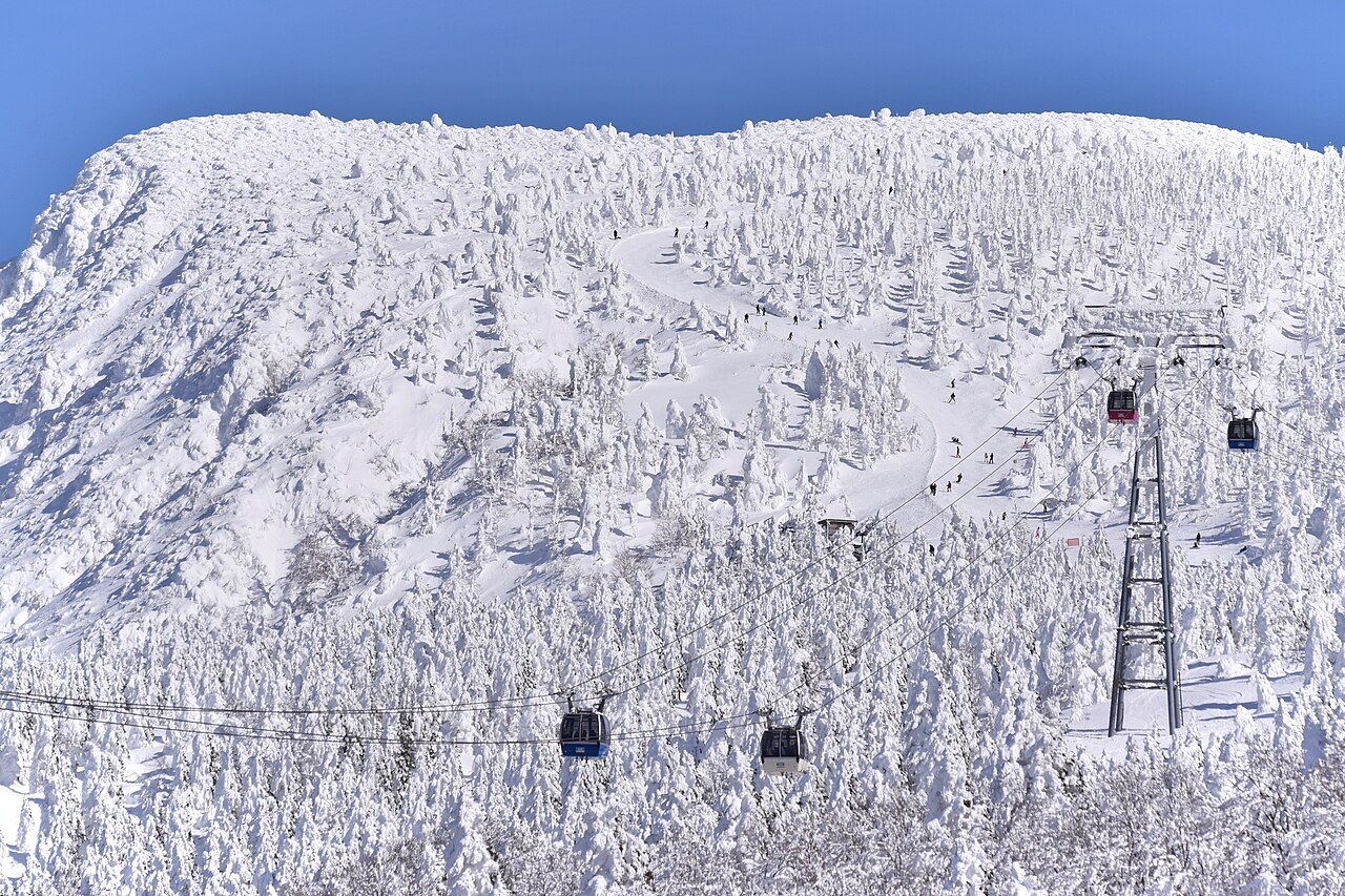
Zao Onsen Ski Resort is a downhill ski area in Yamagata Prefecture, Japan. Mapped terrain includes beginner, easy, intermediate, advanced routes. Its mapped lift network extends from approximately 792 to 1661 metres above sea level. Cross-country skiing is also mapped within the area.
Data: OpenSkiData / OpenSkiMap, OpenStreetMap contributors (ODbL), Skimap.org, Who's On First, Mapterhorn.
Zao Onsen Ski Resort - Base lift station
ECMWF · Cycle du modèle : Prochaine mise à jour attendue :
Jour Heure (UTC) Temp. (°C) Humidité (%) Vent (km/h) Vent (nœuds) Vent (Bft) Direction Précip. (mm) Neige fraîche (cm) Pression (hPa) Isotherme 0 °C (m) Conditions | Mercredi, 04/11 06:00 9 62 11 6 2B SE — — 1028 2576 Overcast 98% cloud 09:00 7.9 62 23 13 4B SE 0 0 1028 3009 Overcast 100% cloud 12:00 8 59 27 15 4B SE 0 0 1028 2913 Overcast 100% cloud 15:00 7.7 76 26 14 4B S 2.4 0 1027 2839 Overcast 100% cloud 18:00 8.4 86 19 10 3B S 8.4 0 1025 2859 Overcast 100% cloud 21:00 8.7 90 26 14 4B SE 6.3 0 1023 3022 Overcast 100% cloud Jeudi, 05/11 00:00 9.1 93 31 17 5B SE 5.1 0 1020 3102 Overcast 98% cloud 03:00 9.9 96 22 12 4B SE 0.29 0 1015 3073 Overcast 100% cloud 06:00 10.5 96 17 9 3B SE 0.28 0 1012 3048 Overcast 97% cloud 09:00 11.1 95 9 5 2B SE 0.05 0 1010 3035 Overcast 94% cloud 12:00 11.5 92 7 4 2B SW 0.47 0 1008 3022 Overcast 99% cloud 15:00 12.2 83 13 7 3B W 0.32 0 1005 3003 Cloudy 79% cloud 18:00 11.5 83 20 11 4B W 0.28 0 1004 2982 Cloudy 64% cloud 21:00 10.6 87 30 16 5B W 1.9 0 1004 2975 Overcast 89% cloud Vendredi, 06/11 00:00 9.9 91 36 20 5B W 0.42 0 1005 2790 Overcast 82% cloud 03:00 10.1 79 44 24 6B W 0.82 0 1005 2724 Partly cloudy 43% cloud 06:00 10.2 75 47 25 6B W 0.28 0 1006 2707 Cloudy 66% cloud 09:00 8.4 87 47 25 6B W 0.80 0 1009 2453 Overcast 86% cloud 12:00 6.2 90 37 20 5B W 0.81 0 1011 1976 Overcast 100% cloud 15:00 3.5 92 41 22 6B NW 1.9 0 1013 1428 Overcast 100% cloud 18:00 1.6 91 45 24 6B W 1.7 0 1014 1169 Overcast 99% cloud 21:00 1 91 45 24 6B W 2.2 0.7 1015 1077 Overcast 99% cloud Samedi, 07/11 00:00 0.5 90 49 26 6B W 2.2 0.7 1017 996 Overcast 85% cloud 03:00 0.2 90 56 30 7B W 2.4 0.7 1018 959 Overcast 84% cloud 06:00 0.1 81 62 34 8B W 1.9 0.6 1019 946 Cloudy 78% cloud 09:00 -0.3 81 58 31 7B W 1.1 0.3 1022 887 Cloudy 79% cloud 12:00 -0.3 84 56 30 7B W 1.0 0.3 1024 887 Overcast 81% cloud 15:00 -0 86 59 32 7B W 0.78 0.2 1026 924 Overcast 85% cloud 18:00 0.2 85 57 31 7B W 0.44 0.1 1027 949 Overcast 84% cloud 21:00 0 86 59 32 7B NW 0.22 0 1027 933 Overcast 82% cloud Dimanche, 08/11 00:00 0.9 77 46 25 6B W 0 0 1029 1030 Overcast 82% cloud 03:00 1.5 67 46 25 6B W 0.02 0 1030 1087 Overcast 83% cloud 06:00 1.5 68 41 22 6B W 0 0 1030 1089 Overcast 90% cloud 09:00 0.8 78 32 17 5B W 0.07 0 1031 1031 Overcast 87% cloud 12:00 1.1 79 27 14 4B W 0 0 1032 1065 Cloudy 78% cloud 15:00 1.2 80 22 12 4B W 0 0 1031 1089 Overcast 94% cloud 18:00 1 84 22 12 4B W 0.09 0 1030 1062 Overcast 97% cloud 21:00 0.8 85 13 7 3B W 0.18 0 1030 1067 Overcast 92% cloud Lundi, 09/11 00:00 1.5 80 8 4 2B W 0.04 0 1028 1201 Cloudy 66% cloud 03:00 3.2 74 4 2 1B W 0 0 1024 1327 Overcast 90% cloud 06:00 4.1 74 7 4 2B W 0.03 0 1023 1402 Overcast 92% cloud 09:00 3.3 80 11 6 2B W 0 0 1023 1395 Overcast 94% cloud 12:00 1.4 91 21 12 4B NW 0.64 0 1024 1160 Overcast 98% cloud 15:00 -0.2 90 36 19 5B NW 0.14 0 1024 902 Overcast 80% cloud 18:00 -0.8 86 44 24 6B W 0.04 0 1023 813 Overcast 82% cloud 21:00 -1 90 40 22 6B NW 0.03 0 1024 793 Overcast 88% cloud Mardi, 10/11 00:00 -1.4 77 33 18 5B NW 0 0 1026 783 Partly cloudy 50% cloud 03:00 -1.2 71 27 15 4B NW 0.05 0 1026 811 Cloudy 75% cloud 06:00 -0.7 68 23 12 4B NW 0 0 1027 849 Overcast 81% cloud |
|---|
Forecast notes
Forecast table times: UTC.
Coordinates: 38.1706381°N, 140.3989138°E · Requested elevation: 925 m. Model terrain: 474 m. Terrain and 1000/925/850/700 hPa profiles are used for height estimates.
These are altitude estimates, not a simulation of local mountain terrain. Precipitation, cloud and sea-level pressure use horizontal interpolation only.
Precipitation includes rain and snow water equivalent: preceding 3 hours through day 6, then 6 hours (see cell tooltip). Snow (cm) estimates fresh snowfall from precipitation and temperature using the GFS conversion; it is not snow depth on the ground. Freezing (m) uses additional 600/500 hPa temperatures when available and estimates the lowest resolved 0°C crossing above sea level. When all sampled levels are warm, the upper profile limit is shown (see tooltip). < marks an entirely cold sampled profile and its lower height limit. No extrapolation is used.
Source: ECMWF · CC BY 4.0 · Processed by Snow Report.
Zao Onsen Ski Resort - Top lift station
ECMWF · Cycle du modèle : Prochaine mise à jour attendue :
Jour Heure (UTC) Temp. (°C) Humidité (%) Vent (km/h) Vent (nœuds) Vent (Bft) Direction Précip. (mm) Neige fraîche (cm) Pression (hPa) Isotherme 0 °C (m) Conditions | Mercredi, 04/11 06:00 3 75 13 7 3B S — — 1028 2577 Overcast 98% cloud 09:00 4.6 53 23 12 4B S 0 0 1029 3002 Overcast 100% cloud 12:00 5.3 71 31 17 5B S 0 0 1028 2904 Overcast 100% cloud 15:00 5.7 82 35 19 5B S 2.5 0 1027 2840 Overcast 100% cloud 18:00 5.7 86 31 17 5B S 8.4 0 1025 2853 Overcast 100% cloud 21:00 5.8 94 49 26 6B SE 6.2 0 1023 3029 Overcast 100% cloud Jeudi, 05/11 00:00 7.2 82 53 28 7B SE 5.3 0 1020 3103 Overcast 99% cloud 03:00 7.3 94 41 22 6B SE 0.34 0 1015 3073 Overcast 100% cloud 06:00 7.6 93 30 16 5B SE 0.33 0 1012 3049 Overcast 98% cloud 09:00 8.3 91 19 10 3B S 0.05 0 1010 3035 Overcast 95% cloud 12:00 9.1 83 25 13 4B SW 0.63 0 1008 3022 Overcast 99% cloud 15:00 9.2 82 31 17 5B W 0.44 0 1005 3003 Overcast 80% cloud 18:00 8 85 40 21 6B W 0.36 0 1003 2983 Cloudy 60% cloud 21:00 7.1 87 56 30 7B W 2.0 0 1004 2975 Overcast 88% cloud Vendredi, 06/11 00:00 5.4 88 66 36 8B W 0.41 0 1005 2802 Overcast 83% cloud 03:00 5.3 72 78 42 9B W 0.82 0 1005 2755 Partly cloudy 45% cloud 06:00 5.1 80 80 43 9B W 0.27 0 1005 2731 Cloudy 70% cloud 09:00 3.8 82 77 41 9B W 0.75 0 1009 2499 Overcast 90% cloud 12:00 1.8 92 65 35 8B W 0.71 0 1011 2001 Overcast 100% cloud 15:00 -1 94 63 34 8B W 1.7 0.5 1013 1441 Overcast 100% cloud 18:00 -2.8 89 76 41 9B W 1.5 0.5 1014 1178 Overcast 99% cloud 21:00 -3.6 91 78 42 9B W 2.0 2 1015 1089 Overcast 99% cloud Samedi, 07/11 00:00 -4.7 89 86 46 9B W 2.1 2.1 1017 995 Overcast 87% cloud 03:00 -4.9 88 97 52 10B W 2.1 2.1 1017 963 Overcast 87% cloud 06:00 -5.4 86 98 53 10B W 1.8 1.8 1019 943 Cloudy 79% cloud 09:00 -5.3 81 95 51 10B W 1.1 1.1 1022 885 Overcast 81% cloud 12:00 -5.3 86 91 49 10B W 0.98 1 1024 881 Overcast 82% cloud 15:00 -5 84 94 51 10B W 0.80 0.8 1025 924 Overcast 84% cloud 18:00 -4.4 80 92 50 10B W 0.45 0.4 1026 949 Overcast 84% cloud 21:00 -3.7 77 94 51 10B W 0.19 0.2 1027 938 Overcast 81% cloud Dimanche, 08/11 00:00 -4.2 83 69 37 8B W 0 0 1029 1032 Overcast 82% cloud 03:00 -4.2 86 57 31 7B W 0.01 0 1030 1093 Overcast 83% cloud 06:00 -4.2 85 52 28 7B W 0 0 1030 1094 Overcast 89% cloud 09:00 -3.8 84 53 28 7B W 0.07 0.1 1031 1035 Overcast 84% cloud 12:00 -3.8 84 46 25 6B W 0 0 1032 1068 Cloudy 77% cloud 15:00 -3.5 84 39 21 6B W 0 0 1031 1098 Overcast 95% cloud 18:00 -3.7 90 40 22 6B W 0.08 0.1 1030 1072 Overcast 98% cloud 21:00 -3 85 35 19 5B W 0.20 0.2 1030 1076 Overcast 93% cloud Lundi, 09/11 00:00 -2.2 82 30 16 5B W 0.05 0 1028 1208 Cloudy 65% cloud 03:00 -2.1 93 21 11 4B W 0 0 1024 1325 Overcast 89% cloud 06:00 -1.6 92 25 14 4B W 0.02 0 1023 1403 Overcast 90% cloud 09:00 -1.6 96 33 18 5B W 0 0 1023 1399 Overcast 92% cloud 12:00 -2.7 94 37 20 5B W 0.61 0.2 1024 1177 Overcast 99% cloud 15:00 -4.7 77 61 33 7B W 0.13 0.1 1023 913 Overcast 83% cloud 18:00 -5 78 78 42 9B NW 0.05 0 1023 811 Overcast 81% cloud 21:00 -5.4 83 72 39 8B NW 0.02 0 1023 795 Overcast 88% cloud Mardi, 10/11 00:00 -6.2 65 55 30 7B NW 0 0 1025 790 Partly cloudy 48% cloud 03:00 -6.7 82 37 20 5B NW 0.05 0.1 1026 819 Cloudy 73% cloud 06:00 -6.4 83 30 16 5B NW 0 0 1027 853 Cloudy 78% cloud |
|---|
Forecast notes
Forecast table times: UTC.
Coordinates: 38.1547326°N, 140.4311795°E · Requested elevation: 1661 m. Model terrain: 520 m. Terrain and 1000/925/850/700 hPa profiles are used for height estimates.
These are altitude estimates, not a simulation of local mountain terrain. Precipitation, cloud and sea-level pressure use horizontal interpolation only.
Precipitation includes rain and snow water equivalent: preceding 3 hours through day 6, then 6 hours (see cell tooltip). Snow (cm) estimates fresh snowfall from precipitation and temperature using the GFS conversion; it is not snow depth on the ground. Freezing (m) uses additional 600/500 hPa temperatures when available and estimates the lowest resolved 0°C crossing above sea level. When all sampled levels are warm, the upper profile limit is shown (see tooltip). < marks an entirely cold sampled profile and its lower height limit. No extrapolation is used.