Previsiones para estaciones de esquí de todo el mundo

Guía de colores Temperatura · Viento · Lluvia · Nieve
Cada color comienza en el valor indicado. Los colores del viento coinciden en las tres unidades. Las celdas sin precipitación permanecen neutras. Los colores describen los valores mostrados, no son avisos meteorológicos oficiales.
Yunomaru (湯の丸スキー場) - Low lift station
ECMWF · Ejecución del modelo: Próxima actualización prevista:
Día Hora (UTC) Temp. (°C) Humedad (%) Viento (km/h) Viento (nudos) Viento (Bft) Dirección Precip. (mm) Nieve nueva (cm) Presión (hPa) Isoterma de 0 °C (m) Condiciones | Miércoles, 04/11 06:00 5.1 89 18 10 3B SE — — 1028 3150 Overcast 100% cloud  09:00 4.8 92 26 14 4B SE 0.17 0 1029 3155 Overcast 100% cloud 12:00 4.6 94 33 18 5B SE 2.3 0 1028 3148 Overcast 100% cloud 15:00 5.3 93 27 15 4B SE 3.9 0 1026 3137 Overcast 100% cloud 18:00 5.9 93 24 13 4B SE 4.6 0 1023 3126 Overcast 100% cloud 21:00 7.1 87 23 12 4B SE 3.3 0 1021 3117 Overcast 100% cloud Jueves, 05/11 00:00 7.5 90 16 9 3B SE 0.11 0 1018 3104 Overcast 92% cloud 03:00 9.6 81 17 9 3B SW 0 0 1014 3076 Overcast 92% cloud 06:00 10.7 77 16 8 3B SW 0.08 0 1010 3055 Partly cloudy 49% cloud  09:00 7.8 91 16 8 3B W 0 0 1010 3046 Overcast 81% cloud 12:00 6.8 93 18 10 3B W 0.01 0 1008 3034 Cloudy 72% cloud  15:00 6.9 85 22 12 4B W 0.03 0 1006 3017 Partly cloudy 44% cloud 18:00 6.3 87 27 15 4B W 1.4 0 1004 3002 Cloudy 52% cloud 21:00 5.5 92 21 11 4B W 2.2 0 1006 3004 Cloudy 59% cloud Viernes, 06/11 00:00 8.4 77 27 14 4B W 0.42 0 1008 3015 Partly cloudy 29% cloud 03:00 9.9 52 33 18 5B W 0.11 0 1007 2973 Partly cloudy 24% cloud 06:00 9.2 49 30 16 5B W 0 0 1008 2933 Partly cloudy 34% cloud 09:00 5.6 66 22 12 4B W 0 0 1011 2743 Partly cloudy 33% cloud 12:00 3.5 74 25 13 4B W 0.03 0 1013 2352 Partly cloudy 39% cloud 15:00 1.6 87 24 13 4B W 0.06 0 1015 2010 Cloudy 60% cloud 18:00 -0.1 90 26 14 4B W 0.32 0.1 1017 1714 Overcast 81% cloud 21:00 -1.4 89 31 17 5B W 0.09 0 1019 1473 Overcast 92% cloud Sábado, 07/11 00:00 -0.1 76 32 18 5B W 0.11 0 1020 1718 Cloudy 51% cloud 03:00 1.2 62 36 19 5B W 0.11 0 1020 1863 Cloudy 55% cloud 06:00 -1 70 38 21 5B NW 0.09 0 1023 1565 Cloudy 58% cloud 09:00 -2.2 70 32 17 5B NW 0 0 1027 1254 Partly cloudy 43% cloud 12:00 -2.3 72 29 15 4B NW 0 0 1029 < 1159 Cloudy 73% cloud 15:00 -2.2 64 25 14 4B NW 0 0 1031 < 1159 Cloudy 70% cloud 18:00 -1.8 64 27 14 4B NW 0 0 1031 < 1159 Cloudy 75% cloud 21:00 -1.9 65 26 14 4B NW 0 0 1033 < 1159 Cloudy 73% cloud Domingo, 08/11 00:00 -0.9 62 20 11 4B NW 0 0 1033 1467 Cloudy 74% cloud 03:00 0.7 59 17 9 3B NW 0 0 1031 2142 Partly cloudy 43% cloud 06:00 1.1 59 13 7 3B NW 0 0 1030 2287 Overcast 81% cloud 09:00 0.6 64 11 6 2B NW 0 0 1032 2040 Overcast 95% cloud 12:00 0.8 64 10 5 2B W 0 0 1032 2017 Overcast 85% cloud 15:00 1.1 67 14 8 3B SW 0 0 1030 1207 Overcast 91% cloud 18:00 1 67 13 7 3B W 0 0 1029 1985 Overcast 92% cloud 21:00 1.6 67 16 8 3B SW 0.06 0 1028 2083 Overcast 86% cloud Lunes, 09/11 00:00 2.5 67 18 10 3B SW 0.07 0 1027 2254 Cloudy 68% cloud 03:00 4.2 66 14 8 3B SW 0.02 0 1022 2420 Partly cloudy 43% cloud 06:00 3.9 73 7 4 2B NW 0 0 1021 2297 Cloudy 56% cloud 09:00 2 83 10 5 2B W 0 0 1023 2056 Cloudy 59% cloud 12:00 0.8 86 18 10 3B NW 0.13 0 1024 1865 Overcast 81% cloud 15:00 -1.2 82 24 13 4B NW 0.28 0.1 1025 1463 Overcast 88% cloud 18:00 -2.4 75 30 16 5B NW 0 0 1025 1199 Cloudy 77% cloud 21:00 -3.1 71 31 17 5B NW 0 0 1026 < 1159 Cloudy 67% cloud Martes, 10/11 00:00 -2.9 73 26 14 4B NW 0 0 1027 1309 Cloudy 61% cloud 03:00 -1.9 73 19 10 3B NW 0.06 0 1026 1426 Cloudy 55% cloud 06:00 -1.4 61 16 9 3B NW 0 0 1026 1463 Clear 11% cloud  |
|---|
Forecast notes
Forecast table times: UTC.
Coordinates: 36.4282711°N, 138.4205049°E · Requested elevation: 1724 m. Model terrain: 1156 m. Terrain and 1000/925/850/700 hPa profiles are used for height estimates.
These are altitude estimates, not a simulation of local mountain terrain. Precipitation, cloud and sea-level pressure use horizontal interpolation only.
Precipitation includes rain and snow water equivalent: preceding 3 hours through day 6, then 6 hours (see cell tooltip). Snow (cm) estimates fresh snowfall from precipitation and temperature using the GFS conversion; it is not snow depth on the ground. Freezing (m) uses additional 600/500 hPa temperatures when available and estimates the lowest resolved 0°C crossing above sea level. When all sampled levels are warm, the upper profile limit is shown (see tooltip). < marks an entirely cold sampled profile and its lower height limit. No extrapolation is used.
Source: ECMWF · CC BY 4.0 · Processed by Snow Report.
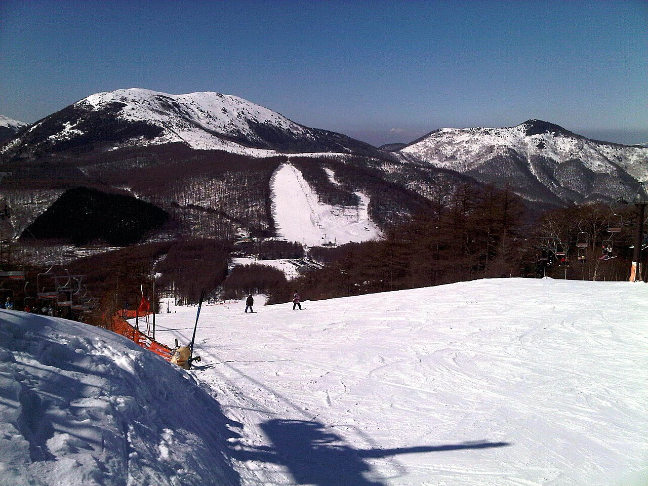
Yunomaru (湯の丸スキー場) is a downhill ski area in Gunma Prefecture, Japan. Its mapped lift network extends from approximately 1724 to 1960 metres above sea level.
Data: OpenSkiData / OpenSkiMap, OpenStreetMap contributors (ODbL), Skimap.org, Who's On First, Mapterhorn.
Yunomaru (湯の丸スキー場) - Base lift station
ECMWF · Ejecución del modelo: Próxima actualización prevista:
Día Hora (UTC) Temp. (°C) Humedad (%) Viento (km/h) Viento (nudos) Viento (Bft) Dirección Precip. (mm) Nieve nueva (cm) Presión (hPa) Isoterma de 0 °C (m) Condiciones | Miércoles, 04/11 06:00 5 89 18 10 3B SE — — 1028 3150 Overcast 100% cloud 09:00 4.7 92 26 14 4B SE 0.17 0 1029 3155 Overcast 100% cloud 12:00 4.6 94 33 18 5B SE 2.3 0 1028 3148 Overcast 100% cloud 15:00 5.2 93 27 15 4B SE 3.8 0 1026 3137 Overcast 100% cloud 18:00 5.8 93 24 13 4B SE 4.6 0 1023 3126 Overcast 100% cloud 21:00 7.1 87 22 12 4B SE 3.3 0 1021 3117 Overcast 100% cloud Jueves, 05/11 00:00 7.5 89 16 9 3B SE 0.11 0 1018 3104 Overcast 92% cloud 03:00 9.6 81 18 10 3B SW 0 0 1014 3076 Overcast 92% cloud 06:00 10.6 77 16 9 3B SW 0.08 0 1010 3055 Partly cloudy 49% cloud 09:00 7.8 90 16 9 3B W 0 0 1010 3046 Overcast 81% cloud 12:00 6.8 93 18 10 3B W 0.01 0 1008 3034 Cloudy 72% cloud 15:00 6.8 86 22 12 4B W 0.03 0 1006 3017 Partly cloudy 44% cloud 18:00 6.2 86 28 15 4B W 1.3 0 1004 3002 Cloudy 52% cloud 21:00 5.4 92 21 11 4B W 2.1 0 1006 3004 Cloudy 59% cloud Viernes, 06/11 00:00 8.3 77 27 15 4B W 0.42 0 1008 3015 Partly cloudy 29% cloud 03:00 9.8 52 33 18 5B W 0.11 0 1007 2975 Partly cloudy 24% cloud 06:00 9.1 49 31 17 5B W 0 0 1008 2934 Partly cloudy 34% cloud 09:00 5.6 65 23 12 4B W 0 0 1011 2746 Partly cloudy 33% cloud 12:00 3.4 74 25 14 4B W 0.03 0 1013 2356 Partly cloudy 39% cloud 15:00 1.5 87 24 13 4B W 0.05 0 1015 2013 Cloudy 60% cloud 18:00 -0.1 89 26 14 4B W 0.31 0.1 1017 1716 Overcast 81% cloud 21:00 -1.5 89 31 17 5B W 0.09 0 1019 1477 Overcast 92% cloud Sábado, 07/11 00:00 -0.1 76 33 18 5B W 0.11 0 1020 1721 Cloudy 52% cloud 03:00 1.1 62 37 20 5B W 0.11 0 1020 1865 Cloudy 55% cloud 06:00 -1.1 70 39 21 5B NW 0.09 0 1023 1567 Cloudy 58% cloud 09:00 -2.2 69 33 18 5B NW 0 0 1026 1258 Partly cloudy 43% cloud 12:00 -2.3 72 29 16 5B NW 0 0 1029 < 1157 Cloudy 73% cloud 15:00 -2.2 64 26 14 4B NW 0 0 1031 < 1157 Cloudy 69% cloud 18:00 -1.8 63 27 15 4B NW 0 0 1031 < 1157 Cloudy 74% cloud 21:00 -1.9 64 27 14 4B NW 0 0 1033 < 1157 Cloudy 72% cloud Domingo, 08/11 00:00 -0.9 61 21 11 4B NW 0 0 1033 1469 Cloudy 73% cloud 03:00 0.7 58 17 9 3B NW 0 0 1031 2153 Partly cloudy 42% cloud 06:00 1.1 58 13 7 3B NW 0 0 1030 2296 Overcast 81% cloud 09:00 0.6 63 11 6 2B NW 0 0 1032 2045 Overcast 95% cloud 12:00 0.8 64 11 6 2B W 0 0 1032 2021 Overcast 85% cloud 15:00 1 67 15 8 3B SW 0 0 1030 1201 Overcast 91% cloud 18:00 1 67 13 7 3B W 0 0 1029 1988 Overcast 92% cloud 21:00 1.6 67 16 9 3B SW 0.06 0 1028 2084 Overcast 86% cloud Lunes, 09/11 00:00 2.4 67 19 10 3B SW 0.07 0 1027 2256 Cloudy 68% cloud 03:00 4.1 66 14 8 3B SW 0.02 0 1022 2421 Partly cloudy 43% cloud 06:00 3.8 73 8 4 2B W 0 0 1021 2298 Cloudy 56% cloud 09:00 2 83 10 5 2B W 0 0 1023 2056 Cloudy 59% cloud 12:00 0.8 86 18 10 3B NW 0.13 0 1024 1868 Cloudy 80% cloud 15:00 -1.2 82 24 13 4B NW 0.28 0.1 1025 1466 Overcast 88% cloud 18:00 -2.4 75 31 17 5B NW 0 0 1025 1201 Cloudy 77% cloud 21:00 -3.1 71 32 17 5B NW 0 0 1026 < 1157 Cloudy 66% cloud Martes, 10/11 00:00 -2.9 72 26 14 4B NW 0 0 1027 1310 Cloudy 60% cloud 03:00 -2 73 19 10 3B NW 0.06 0 1026 1428 Cloudy 55% cloud 06:00 -1.5 61 16 9 3B NW 0 0 1026 1465 Clear 11% cloud |
|---|
Forecast notes
Forecast table times: UTC.
Coordinates: 36.4257016°N, 138.421656°E · Requested elevation: 1736 m. Model terrain: 1154 m. Terrain and 1000/925/850/700 hPa profiles are used for height estimates.
These are altitude estimates, not a simulation of local mountain terrain. Precipitation, cloud and sea-level pressure use horizontal interpolation only.
Precipitation includes rain and snow water equivalent: preceding 3 hours through day 6, then 6 hours (see cell tooltip). Snow (cm) estimates fresh snowfall from precipitation and temperature using the GFS conversion; it is not snow depth on the ground. Freezing (m) uses additional 600/500 hPa temperatures when available and estimates the lowest resolved 0°C crossing above sea level. When all sampled levels are warm, the upper profile limit is shown (see tooltip). < marks an entirely cold sampled profile and its lower height limit. No extrapolation is used.
Source: ECMWF · CC BY 4.0 · Processed by Snow Report.
Yunomaru (湯の丸スキー場) - Top lift station
ECMWF · Ejecución del modelo: Próxima actualización prevista:
Día Hora (UTC) Temp. (°C) Humedad (%) Viento (km/h) Viento (nudos) Viento (Bft) Dirección Precip. (mm) Nieve nueva (cm) Presión (hPa) Isoterma de 0 °C (m) Condiciones | Miércoles, 04/11 06:00 4.2 91 21 11 4B S — — 1028 3150 Overcast 100% cloud 09:00 4.1 93 27 15 4B S 0.18 0 1029 3155 Overcast 100% cloud 12:00 3.9 95 35 19 5B S 2.3 0 1028 3148 Overcast 100% cloud 15:00 4.6 94 32 17 5B S 3.8 0 1026 3137 Overcast 100% cloud 18:00 5.2 94 26 14 4B S 4.5 0 1023 3126 Overcast 100% cloud 21:00 6.3 85 22 12 4B S 3.3 0 1021 3118 Overcast 100% cloud Jueves, 05/11 00:00 6.7 84 16 9 3B S 0.11 0 1018 3104 Overcast 92% cloud 03:00 8.4 80 25 14 4B SW 0 0 1014 3076 Overcast 91% cloud 06:00 9.2 77 23 13 4B W 0.09 0 1010 3055 Partly cloudy 48% cloud 09:00 7 89 23 12 4B W 0 0 1010 3046 Overcast 82% cloud 12:00 6.2 91 26 14 4B W 0.01 0 1008 3034 Cloudy 73% cloud 15:00 6.1 86 29 16 5B W 0.02 0 1006 3017 Partly cloudy 44% cloud 18:00 5.4 85 36 20 5B W 1.2 0 1004 3002 Cloudy 52% cloud 21:00 4.6 91 28 15 4B W 1.9 0 1006 3004 Cloudy 58% cloud Viernes, 06/11 00:00 7 73 34 19 5B W 0.39 0 1008 3015 Partly cloudy 28% cloud 03:00 8.1 51 41 22 6B W 0.11 0 1007 2981 Partly cloudy 24% cloud 06:00 7.5 49 38 21 5B W 0 0 1008 2942 Partly cloudy 33% cloud 09:00 4.4 63 29 16 5B W 0 0 1011 2761 Partly cloudy 31% cloud 12:00 2.2 72 32 17 5B W 0.02 0 1013 2369 Partly cloudy 38% cloud 15:00 0.4 85 31 17 5B W 0.04 0 1015 2026 Cloudy 58% cloud 18:00 -1.3 86 34 18 5B W 0.29 0.1 1017 1727 Cloudy 80% cloud 21:00 -2.7 87 40 22 6B W 0.09 0 1018 1491 Overcast 92% cloud Sábado, 07/11 00:00 -1.6 75 42 23 6B W 0.10 0 1020 1739 Cloudy 54% cloud 03:00 -0.7 63 46 25 6B W 0.11 0 1020 1874 Cloudy 57% cloud 06:00 -2.5 67 48 26 6B NW 0.08 0 1023 1571 Cloudy 60% cloud 09:00 -2.9 60 44 24 6B NW 0 0 1026 1273 Partly cloudy 42% cloud 12:00 -2.7 61 41 22 6B NW 0 0 1029 < 1159 Cloudy 71% cloud 15:00 -2.4 54 37 20 5B NW 0 0 1031 < 1159 Cloudy 67% cloud 18:00 -1.7 53 37 20 5B NW 0 0 1031 < 1159 Cloudy 71% cloud 21:00 -1.8 54 35 19 5B NW 0 0 1033 < 1159 Cloudy 70% cloud Domingo, 08/11 00:00 -0.8 53 27 15 4B NW 0 0 1033 1475 Cloudy 72% cloud 03:00 0.4 52 21 11 4B NW 0 0 1031 2197 Partly cloudy 41% cloud 06:00 0.7 54 19 10 3B W 0 0 1030 2330 Overcast 82% cloud 09:00 0.2 60 18 10 3B W 0 0 1032 2061 Overcast 95% cloud 12:00 0.2 62 19 10 3B W 0 0 1032 2032 Overcast 85% cloud 15:00 0.3 66 23 13 4B SW 0 0 1030 1201 Overcast 92% cloud 18:00 0.1 66 22 12 4B W 0 0 1029 1995 Overcast 91% cloud 21:00 0.6 67 25 14 4B SW 0.06 0 1028 2087 Overcast 87% cloud Lunes, 09/11 00:00 1.4 69 27 14 4B SW 0.07 0 1027 2259 Cloudy 69% cloud 03:00 2.8 68 22 12 4B W 0.03 0 1022 2426 Partly cloudy 42% cloud 06:00 2.3 76 14 8 3B W 0 0 1021 2299 Cloudy 56% cloud 09:00 0.6 83 16 9 3B W 0 0 1023 2055 Cloudy 59% cloud 12:00 -0.5 86 23 13 4B NW 0.13 0 1024 1876 Cloudy 78% cloud 15:00 -2.1 75 27 14 4B NW 0.28 0.1 1025 1475 Overcast 87% cloud 18:00 -2.9 66 34 18 5B NW 0 0 1025 1202 Cloudy 75% cloud 21:00 -3.4 61 36 19 5B NW 0 0 1026 < 1159 Cloudy 65% cloud Martes, 10/11 00:00 -3.3 62 30 16 5B NW 0 0 1027 1313 Cloudy 58% cloud 03:00 -2.6 64 23 13 4B NW 0.06 0 1026 1435 Cloudy 54% cloud 06:00 -2.3 56 21 11 4B NW 0 0 1026 1474 Clear 10% cloud |
|---|
Forecast notes
Forecast table times: UTC.
Coordinates: 36.4173652°N, 138.4311993°E · Requested elevation: 1960 m. Model terrain: 1157 m. Terrain and 1000/925/850/700 hPa profiles are used for height estimates.
These are altitude estimates, not a simulation of local mountain terrain. Precipitation, cloud and sea-level pressure use horizontal interpolation only.
Precipitation includes rain and snow water equivalent: preceding 3 hours through day 6, then 6 hours (see cell tooltip). Snow (cm) estimates fresh snowfall from precipitation and temperature using the GFS conversion; it is not snow depth on the ground. Freezing (m) uses additional 600/500 hPa temperatures when available and estimates the lowest resolved 0°C crossing above sea level. When all sampled levels are warm, the upper profile limit is shown (see tooltip). < marks an entirely cold sampled profile and its lower height limit. No extrapolation is used.