Prévisions pour les stations de ski du monde entier

Plus
Guide des couleurs Température · Vent · Pluie · Neige
Chaque couleur commence à la valeur indiquée. Les couleurs du vent correspondent dans les trois unités. Les cases sans précipitations restent neutres. Les couleurs décrivent les valeurs affichées et ne sont pas des alertes officielles.
Wurzeralm - Low lift station
ECMWF · Cycle du modèle : Prochaine mise à jour attendue :
Jour Heure (UTC) Temp. (°C) Humidité (%) Vent (km/h) Vent (nœuds) Vent (Bft) Direction Précip. (mm) Neige fraîche (cm) Pression (hPa) Isotherme 0 °C (m) Conditions | Mercredi, 04/11 06:00 1.6 88 3 2 1B E — — 1028 1225 Overcast 98% cloud  09:00 4.5 77 4 2 1B E 0 0 1028 1805 Overcast 100% cloud 12:00 7.8 64 4 2 1B E 0 0 1027 1970 Overcast 98% cloud 15:00 5.6 72 4 2 1B E 0 0 1027 1963 Overcast 99% cloud 18:00 2 84 4 2 1B SE 0 0 1028 1956 Cloudy 64% cloud  21:00 1.9 87 6 3 2B S 0 0 1029 2170 Partly cloudy 48% cloud  Jeudi, 05/11 00:00 1.7 86 7 4 2B S 0 0 1028 1137 Partly cloudy 40% cloud 03:00 1.6 85 7 4 2B S 0 0 1028 1142 Partly cloudy 43% cloud 06:00 1.3 84 7 4 2B S 0 0 1027 1162 Partly cloudy 45% cloud 09:00 7.9 62 7 4 2B S 0 0 1027 2844 Clear 9% cloud  12:00 11.3 50 5 3 1B SE 0 0 1025 2947 Clear 7% cloud 15:00 8.2 65 3 2 1B SE 0 0 1024 3105 Clear 2% cloud 18:00 2.3 81 6 3 1B S 0 0 1025 3129 Clear 16% cloud 21:00 0.7 82 6 3 2B S 0 0 1025 1183 Clear 18% cloud Vendredi, 06/11 00:00 0.4 79 6 3 1B S 0 0 1023 1191 Clear 9% cloud 03:00 0.5 73 4 2 1B S 0 0 1022 1183 Clear 8% cloud 06:00 0.7 68 4 2 1B S 0 0 1021 1174 Clear 3% cloud 09:00 10.5 45 3 2 1B SE 0 0 1021 3109 Clear 0% cloud 12:00 13.5 37 5 3 1B SE 0 0 1019 3103 Clear 0% cloud 15:00 8.8 59 4 2 1B SE 0 0 1020 3098 Clear 0% cloud 18:00 2.8 76 6 3 2B S 0 0 1021 3019 Clear 0% cloud 21:00 1.2 80 6 3 2B S 0 0 1022 1164 Clear 1% cloud Samedi, 07/11 00:00 0.4 81 6 3 2B S 0 0 1023 1215 Clear 15% cloud 03:00 0 82 5 3 1B S 0 0 1023 1243 Partly cloudy 24% cloud 06:00 -0.4 79 5 3 1B S 0 0 1024 1279 Clear 14% cloud 09:00 7.2 51 3 2 1B SE 0 0 1025 2477 Clear 4% cloud 12:00 9.9 38 5 3 1B SE 0 0 1023 2471 Clear 0% cloud 15:00 6.4 55 4 2 1B SE 0 0 1023 2451 Clear 0% cloud 18:00 1 70 6 3 2B S 0 0 1024 1200 Clear 0% cloud 21:00 -0.8 74 6 3 2B S 0 0 1024 1297 Clear 1% cloud Dimanche, 08/11 00:00 -1.1 68 6 3 2B S 0 0 1024 1312 Clear 20% cloud 03:00 0.1 59 5 3 1B S 0 0 1023 1259 Cloudy 68% cloud 06:00 -0.2 58 4 2 1B S 0 0 1023 1293 Clear 1% cloud 09:00 7.5 38 2 1 1B S 0 0 1024 1998 Overcast 98% cloud 12:00 9.6 40 2 1 1B NW 0 0 1023 2037 Cloudy 59% cloud 15:00 6 60 2 1 1B NE 0 0 1023 1982 Clear 17% cloud 18:00 1.4 72 3 2 1B S 0 0 1024 1174 Clear 1% cloud 21:00 0.2 75 4 2 1B S 0 0 1023 1250 Clear 0% cloud Lundi, 09/11 00:00 -0 75 5 2 1B S 0 0 1023 1254 Clear 0% cloud 03:00 -0.2 75 5 3 1B S 0 0 1021 1242 Clear 0% cloud 06:00 -0 72 5 3 1B S 0 0 1021 1229 Overcast 86% cloud 09:00 9.9 43 3 2 1B S 0 0 1020 2454 Cloudy 80% cloud 12:00 10.1 48 0 0 0B N 0.05 0 1018 2504 Overcast 98% cloud 15:00 8 51 3 2 1B S 0.02 0 1017 2575 Cloudy 54% cloud 18:00 3.1 69 5 3 1B S 0 0 1017 2686 Partly cloudy 26% cloud 21:00 1.8 77 7 4 2B S 0 0 1016 2662 Overcast 88% cloud Mardi, 10/11 00:00 3.7 73 6 3 2B S 0 0 1014 2863 Overcast 100% cloud 03:00 4.7 76 8 4 2B S 0.11 0 1013 2904 Overcast 94% cloud 06:00 5 77 7 4 2B S 0.09 0 1012 2936 Overcast 97% cloud |
|---|
Forecast notes
Forecast table times: UTC.
Coordinates: 47.6274562°N, 14.3150406°E · Requested elevation: 807 m. Model terrain: 1127 m. Terrain and 1000/925/850/700 hPa profiles are used for height estimates.
Outside the available profile, temperature uses an estimated 5.5°C/km height correction; wind retains the nearest available model-level value. Humidity is estimated with adjusted pressure and temperature.
These are altitude estimates, not a simulation of local mountain terrain. Precipitation, cloud and sea-level pressure use horizontal interpolation only.
Precipitation includes rain and snow water equivalent: preceding 3 hours through day 6, then 6 hours (see cell tooltip). Snow (cm) estimates fresh snowfall from precipitation and temperature using the GFS conversion; it is not snow depth on the ground. Freezing (m) uses additional 600/500 hPa temperatures when available and estimates the lowest resolved 0°C crossing above sea level. When all sampled levels are warm, the upper profile limit is shown (see tooltip). < marks an entirely cold sampled profile and its lower height limit. No extrapolation is used.
Source: ECMWF · CC BY 4.0 · Processed by Snow Report.
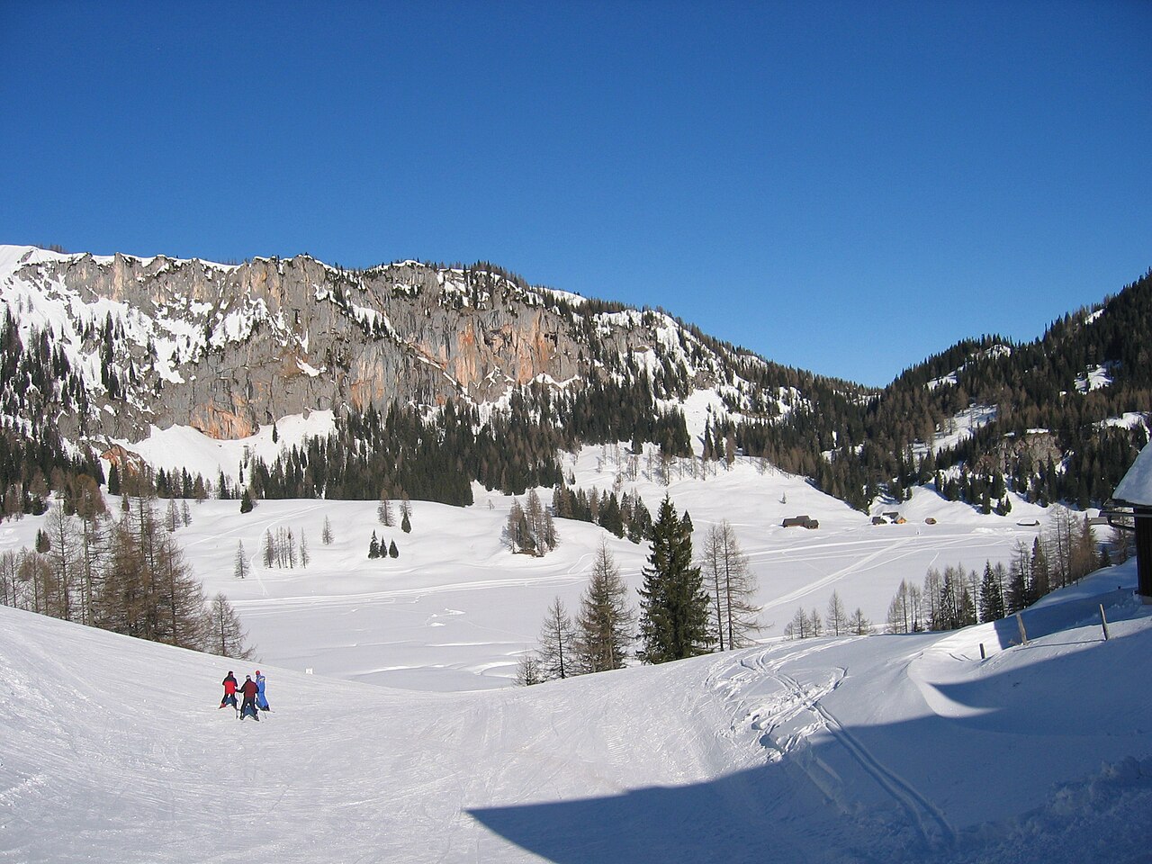
Wurzeralm is a downhill ski area in Upper Austria, Austria. Mapped terrain includes beginner, easy, intermediate, advanced routes. Its mapped lift network extends from approximately 807 to 1859 metres above sea level. Cross-country skiing is also mapped within the area.
Data: OpenSkiData / OpenSkiMap, OpenStreetMap contributors (ODbL), Skimap.org, Who's On First, Mapterhorn.
Wurzeralm - Base lift station
ECMWF · Cycle du modèle : Prochaine mise à jour attendue :
Jour Heure (UTC) Temp. (°C) Humidité (%) Vent (km/h) Vent (nœuds) Vent (Bft) Direction Précip. (mm) Neige fraîche (cm) Pression (hPa) Isotherme 0 °C (m) Conditions | Mercredi, 04/11 06:00 1.6 88 3 2 1B E — — 1028 1225 Overcast 98% cloud 09:00 4.5 77 4 2 1B E 0 0 1028 1805 Overcast 100% cloud 12:00 7.8 64 4 2 1B E 0 0 1027 1970 Overcast 98% cloud 15:00 5.6 72 4 2 1B E 0 0 1027 1963 Overcast 99% cloud 18:00 2 84 4 2 1B SE 0 0 1028 1956 Cloudy 64% cloud 21:00 1.9 87 6 3 2B S 0 0 1029 2170 Partly cloudy 48% cloud Jeudi, 05/11 00:00 1.7 86 7 4 2B S 0 0 1028 1137 Partly cloudy 40% cloud 03:00 1.6 85 7 4 2B S 0 0 1028 1142 Partly cloudy 43% cloud 06:00 1.3 84 7 4 2B S 0 0 1027 1162 Partly cloudy 45% cloud 09:00 7.9 62 7 4 2B S 0 0 1027 2844 Clear 9% cloud 12:00 11.3 50 5 3 1B SE 0 0 1025 2947 Clear 7% cloud 15:00 8.2 65 3 2 1B SE 0 0 1024 3105 Clear 2% cloud 18:00 2.3 81 6 3 1B S 0 0 1025 3129 Clear 16% cloud 21:00 0.7 82 6 3 2B S 0 0 1025 1183 Clear 18% cloud Vendredi, 06/11 00:00 0.4 79 6 3 1B S 0 0 1023 1191 Clear 9% cloud 03:00 0.5 73 4 2 1B S 0 0 1022 1183 Clear 8% cloud 06:00 0.7 68 4 2 1B S 0 0 1021 1174 Clear 3% cloud 09:00 10.5 45 3 2 1B SE 0 0 1021 3109 Clear 0% cloud 12:00 13.5 37 5 3 1B SE 0 0 1019 3103 Clear 0% cloud 15:00 8.8 59 4 2 1B SE 0 0 1020 3098 Clear 0% cloud 18:00 2.8 76 6 3 2B S 0 0 1021 3019 Clear 0% cloud 21:00 1.2 80 6 3 2B S 0 0 1022 1164 Clear 1% cloud Samedi, 07/11 00:00 0.4 81 6 3 2B S 0 0 1023 1215 Clear 15% cloud 03:00 0 82 5 3 1B S 0 0 1023 1243 Partly cloudy 24% cloud 06:00 -0.4 79 5 3 1B S 0 0 1024 1279 Clear 14% cloud 09:00 7.2 51 3 2 1B SE 0 0 1025 2477 Clear 4% cloud 12:00 9.9 38 5 3 1B SE 0 0 1023 2471 Clear 0% cloud 15:00 6.4 55 4 2 1B SE 0 0 1023 2451 Clear 0% cloud 18:00 1 70 6 3 2B S 0 0 1024 1200 Clear 0% cloud 21:00 -0.8 74 6 3 2B S 0 0 1024 1297 Clear 1% cloud Dimanche, 08/11 00:00 -1.1 68 6 3 2B S 0 0 1024 1312 Clear 20% cloud 03:00 0.1 59 5 3 1B S 0 0 1023 1259 Cloudy 68% cloud 06:00 -0.2 58 4 2 1B S 0 0 1023 1293 Clear 1% cloud 09:00 7.5 38 2 1 1B S 0 0 1024 1998 Overcast 98% cloud 12:00 9.6 40 2 1 1B NW 0 0 1023 2037 Cloudy 59% cloud 15:00 6 60 2 1 1B NE 0 0 1023 1982 Clear 17% cloud 18:00 1.4 72 3 2 1B S 0 0 1024 1174 Clear 1% cloud 21:00 0.2 75 4 2 1B S 0 0 1023 1250 Clear 0% cloud Lundi, 09/11 00:00 -0 75 5 2 1B S 0 0 1023 1254 Clear 0% cloud 03:00 -0.2 75 5 3 1B S 0 0 1021 1242 Clear 0% cloud 06:00 -0 72 5 3 1B S 0 0 1021 1229 Overcast 86% cloud 09:00 9.9 43 3 2 1B S 0 0 1020 2454 Cloudy 80% cloud 12:00 10.1 48 0 0 0B N 0.05 0 1018 2504 Overcast 98% cloud 15:00 8 51 3 2 1B S 0.02 0 1017 2575 Cloudy 54% cloud 18:00 3.1 69 5 3 1B S 0 0 1017 2686 Partly cloudy 26% cloud 21:00 1.8 77 7 4 2B S 0 0 1016 2662 Overcast 88% cloud Mardi, 10/11 00:00 3.7 73 6 3 2B S 0 0 1014 2863 Overcast 100% cloud 03:00 4.7 76 8 4 2B S 0.11 0 1013 2904 Overcast 94% cloud 06:00 5 77 7 4 2B S 0.09 0 1012 2936 Overcast 97% cloud |
|---|
Forecast notes
Forecast table times: UTC.
Coordinates: 47.6274562°N, 14.3150406°E · Requested elevation: 807 m. Model terrain: 1127 m. Terrain and 1000/925/850/700 hPa profiles are used for height estimates.
Outside the available profile, temperature uses an estimated 5.5°C/km height correction; wind retains the nearest available model-level value. Humidity is estimated with adjusted pressure and temperature.
These are altitude estimates, not a simulation of local mountain terrain. Precipitation, cloud and sea-level pressure use horizontal interpolation only.
Precipitation includes rain and snow water equivalent: preceding 3 hours through day 6, then 6 hours (see cell tooltip). Snow (cm) estimates fresh snowfall from precipitation and temperature using the GFS conversion; it is not snow depth on the ground. Freezing (m) uses additional 600/500 hPa temperatures when available and estimates the lowest resolved 0°C crossing above sea level. When all sampled levels are warm, the upper profile limit is shown (see tooltip). < marks an entirely cold sampled profile and its lower height limit. No extrapolation is used.
Source: ECMWF · CC BY 4.0 · Processed by Snow Report.
Wurzeralm - Top lift station
ECMWF · Cycle du modèle : Prochaine mise à jour attendue :
Jour Heure (UTC) Temp. (°C) Humidité (%) Vent (km/h) Vent (nœuds) Vent (Bft) Direction Précip. (mm) Neige fraîche (cm) Pression (hPa) Isotherme 0 °C (m) Conditions | Mercredi, 04/11 06:00 -0.7 89 14 8 3B SE — — 1028 1217 Overcast 99% cloud 09:00 -0.3 86 15 8 3B SE 0 0 1028 1804 Overcast 100% cloud 12:00 0.6 82 14 8 3B SE 0 0 1027 1987 Overcast 98% cloud 15:00 0.4 84 18 9 3B SE 0 0 1027 1964 Overcast 99% cloud 18:00 0.5 81 18 9 3B SE 0 0 1028 1997 Cloudy 59% cloud 21:00 1.4 70 19 10 3B SE 0 0 1029 1144 Partly cloudy 47% cloud Jeudi, 05/11 00:00 1.8 68 17 9 3B S 0 0 1028 1158 Partly cloudy 37% cloud 03:00 2.9 59 15 8 3B S 0 0 1028 1140 Partly cloudy 41% cloud 06:00 3.9 53 13 7 3B S 0 0 1027 1159 Partly cloudy 43% cloud 09:00 4.4 49 13 7 3B SE 0 0 1027 2862 Clear 8% cloud 12:00 4.6 55 12 6 2B S 0 0 1024 2958 Clear 4% cloud 15:00 4.9 50 8 4 2B S 0 0 1024 3112 Clear 2% cloud 18:00 5.7 38 7 4 2B SE 0 0 1025 3131 Clear 15% cloud 21:00 6 34 8 4 2B S 0 0 1025 1162 Clear 18% cloud Vendredi, 06/11 00:00 6.3 29 7 4 2B S 0 0 1023 1171 Clear 7% cloud 03:00 6.3 27 7 4 2B SE 0 0 1022 1151 Clear 7% cloud 06:00 6.5 26 9 5 2B SE 0 0 1021 1132 Clear 3% cloud 09:00 6.5 25 12 7 2B SE 0 0 1021 3108 Clear 0% cloud 12:00 6.6 35 13 7 3B SE 0 0 1019 3102 Clear 0% cloud 15:00 5.9 41 14 8 3B SE 0 0 1019 3098 Clear 0% cloud 18:00 5.5 34 15 8 3B SE 0 0 1020 3027 Clear 0% cloud 21:00 4.7 36 17 9 3B SE 0 0 1022 1153 Clear 1% cloud Samedi, 07/11 00:00 3.6 34 20 11 3B S 0 0 1022 1204 Clear 12% cloud 03:00 3 32 19 10 3B S 0 0 1023 1239 Clear 19% cloud 06:00 2.5 33 17 9 3B S 0 0 1024 1270 Clear 13% cloud 09:00 2.4 31 19 10 3B S 0 0 1025 2490 Clear 3% cloud 12:00 2.6 39 21 11 4B S 0 0 1023 2486 Clear 0% cloud 15:00 2.4 40 22 12 4B S 0 0 1023 2471 Clear 0% cloud 18:00 2.5 29 22 12 4B S 0 0 1024 1168 Clear 0% cloud 21:00 2.3 20 21 11 4B S 0 0 1024 1284 Clear 1% cloud Dimanche, 08/11 00:00 2 20 19 10 3B S 0 0 1024 1298 Partly cloudy 22% cloud 03:00 1.6 31 15 8 3B S 0 0 1023 1234 Cloudy 73% cloud 06:00 0.9 36 11 6 2B S 0 0 1023 1270 Clear 0% cloud 09:00 0.8 46 11 6 2B SW 0 0 1024 1994 Overcast 99% cloud 12:00 1.2 53 9 5 2B SW 0 0 1023 2030 Cloudy 54% cloud 15:00 0.9 58 5 3 1B W 0 0 1023 1985 Clear 20% cloud 18:00 0.7 60 7 4 2B W 0 0 1024 1141 Clear 2% cloud 21:00 1.2 57 10 5 2B W 0 0 1023 1224 Clear 0% cloud Lundi, 09/11 00:00 1.6 51 10 5 2B SW 0 0 1022 1224 Clear 0% cloud 03:00 2.5 37 11 6 2B W 0 0 1021 1215 Clear 0% cloud 06:00 3.1 32 10 6 2B SW 0 0 1020 1203 Overcast 87% cloud 09:00 3.6 37 10 5 2B SW 0 0 1020 2449 Overcast 80% cloud 12:00 3.9 46 11 6 2B W 0.07 0 1018 2491 Overcast 98% cloud 15:00 4.2 43 13 7 3B SW 0.00 0 1017 2582 Cloudy 53% cloud 18:00 4.4 47 16 9 3B W 0 0 1017 2683 Partly cloudy 25% cloud 21:00 4.5 51 16 9 3B SW 0 0 1016 2670 Overcast 88% cloud Mardi, 10/11 00:00 5.2 64 23 12 4B W 0 0 1014 2853 Overcast 100% cloud 03:00 5.2 67 23 12 4B W 0.14 0 1013 2898 Overcast 93% cloud 06:00 5.9 66 26 14 4B W 0.12 0 1012 2936 Overcast 97% cloud |
|---|
Forecast notes
Forecast table times: UTC.
Coordinates: 47.6480177°N, 14.2537278°E · Requested elevation: 1859 m. Model terrain: 1115 m. Terrain and 1000/925/850/700 hPa profiles are used for height estimates.
These are altitude estimates, not a simulation of local mountain terrain. Precipitation, cloud and sea-level pressure use horizontal interpolation only.
Precipitation includes rain and snow water equivalent: preceding 3 hours through day 6, then 6 hours (see cell tooltip). Snow (cm) estimates fresh snowfall from precipitation and temperature using the GFS conversion; it is not snow depth on the ground. Freezing (m) uses additional 600/500 hPa temperatures when available and estimates the lowest resolved 0°C crossing above sea level. When all sampled levels are warm, the upper profile limit is shown (see tooltip). < marks an entirely cold sampled profile and its lower height limit. No extrapolation is used.