Wettervorhersagen für Skigebiete weltweit

Farbskala Temperatur · Wind · Regen · Schnee
Jede Farbe beginnt beim angegebenen Wert. Die Windfarben stimmen in allen drei Einheiten überein. Trockene Zellen bleiben neutral. Die Farben beschreiben die Werte und sind keine amtlichen Wetterwarnungen.
Wild Mountain - Low lift station
ECMWF · Modelllauf: Nächste Aktualisierung erwartet:
Tag Uhrzeit (UTC) Temp. (°C) Luftfeuchtigkeit (%) Wind (km/h) Wind (Knoten) Wind (Bft) Richtung Niederschlag (mm) Neuschnee (cm) Luftdruck (hPa) Nullgradgrenze (m) Wetterlage | Mittwoch, 04/11 06:00 12.9 99 2 1 1B E — — 1000 2966 Overcast 99% cloud  09:00 13.6 98 9 5 2B NE 6.7 0 998 2944 Overcast 95% cloud 12:00 13.8 98 12 6 2B SE 1.7 0 997 2926 Overcast 98% cloud 15:00 13.9 94 12 6 2B S 0.19 0 997 2889 Overcast 100% cloud 18:00 13.1 85 14 7 3B S 0.29 0 997 2875 Overcast 100% cloud 21:00 11.7 92 13 7 3B S 1.1 0 998 2834 Overcast 100% cloud Donnerstag, 05/11 00:00 10.3 96 9 5 2B S 0.93 0 999 2765 Overcast 100% cloud 03:00 9.9 97 5 3 1B W 0.77 0 1001 2732 Overcast 100% cloud 06:00 9.6 96 19 10 3B N 0.93 0 1002 2670 Overcast 100% cloud 09:00 8.9 92 24 13 4B N 0.64 0 1004 2166 Overcast 100% cloud 12:00 8.4 72 22 12 4B N 0.27 0 1008 2235 Overcast 95% cloud 15:00 8.7 65 23 12 4B N 0.02 0 1011 2425 Cloudy 73% cloud  18:00 8.7 64 21 11 4B N 0 0 1014 2992 Overcast 100% cloud 21:00 8.7 59 18 10 3B N 0 0 1016 1182 Overcast 99% cloud Freitag, 06/11 00:00 6.9 60 17 9 3B N 0 0 1019 994 Overcast 92% cloud 03:00 5.3 62 13 7 3B N 0 0 1021 855 Overcast 90% cloud 06:00 3.4 69 10 5 2B NE 0 0 1023 700 Partly cloudy 32% cloud  09:00 1.5 81 7 4 2B N 0 0 1025 536 Clear 9% cloud  12:00 0.1 88 6 3 2B N 0 0 1026 < 297 Clear 2% cloud 15:00 3.1 74 6 3 1B N 0 0 1027 657 Clear 0% cloud 18:00 6.8 54 3 2 1B N 0 0 1026 817 Clear 3% cloud 21:00 7.5 53 5 3 1B NW 0 0 1024 2941 Clear 2% cloud Samstag, 07/11 00:00 4 72 2 1 1B W 0 0 1025 3050 Clear 2% cloud 03:00 2.9 80 3 1 1B S 0 0 1025 3004 Overcast 96% cloud 06:00 1.7 88 6 3 2B SW 0 0 1024 3089 Clear 4% cloud 09:00 2 90 8 4 2B S 0 0 1023 3041 Overcast 96% cloud 12:00 1.1 91 6 3 2B S 0 0 1024 2894 Clear 0% cloud 15:00 4.5 82 12 7 3B S 0 0 1023 2912 Clear 0% cloud 18:00 9.6 60 14 8 3B SW 0 0 1021 3078 Cloudy 57% cloud 21:00 10.9 59 14 8 3B SW 0 0 1019 3072 Partly cloudy 39% cloud Sonntag, 08/11 00:00 7.2 79 11 6 2B SW 0 0 1018 3076 Cloudy 73% cloud 03:00 7.4 82 15 8 3B SW 0 0 1016 3072 Cloudy 77% cloud 06:00 7.8 85 15 8 3B SW 0 0 1016 3066 Overcast 90% cloud 09:00 7 85 13 7 3B W 0 0 1017 3066 Cloudy 78% cloud 12:00 5 88 12 6 2B NW 0 0 1018 3065 Cloudy 64% cloud 15:00 8.2 71 13 7 3B NW 0 0 1020 3073 Clear 11% cloud 18:00 12.4 53 15 8 3B NW 0 0 1020 3081 Partly cloudy 40% cloud 21:00 13.1 50 13 7 3B NW 0 0 1019 3082 Clear 9% cloud Montag, 09/11 00:00 7.2 76 8 4 2B W 0 0 1020 3091 Clear 0% cloud 03:00 5.1 85 5 3 1B W 0 0 1021 3097 Clear 11% cloud 06:00 4 90 1 1 0B S 0 0 1021 3103 Clear 19% cloud 09:00 3.4 94 9 5 2B S 0 0 1020 3102 Partly cloudy 30% cloud 12:00 4 94 13 7 3B S 0 0 1020 3099 Overcast 94% cloud 15:00 7.3 81 15 8 3B S 0 0 1019 3098 Overcast 88% cloud 18:00 13.1 57 16 9 3B SW 0 0 1017 3089 Cloudy 70% cloud 21:00 15.2 60 14 8 3B SW 0 0 1014 3073 Partly cloudy 39% cloud Dienstag, 10/11 00:00 10.7 82 9 5 2B SW 0 0 1014 3068 Overcast 88% cloud 03:00 8.9 87 12 6 2B W 0 0 1014 3049 Overcast 86% cloud 06:00 7.2 83 12 7 2B NW 0 0 1015 2860 Cloudy 61% cloud |
|---|
Forecast notes
Forecast table times: UTC.
Coordinates: 45.4899609°N, -92.706269°E · Requested elevation: 237 m. Model terrain: 295 m. Terrain and 1000/925/850/700 hPa profiles are used for height estimates.
Outside the available profile, temperature uses an estimated 5.5°C/km height correction; wind retains the nearest available model-level value. Humidity is estimated with adjusted pressure and temperature.
These are altitude estimates, not a simulation of local mountain terrain. Precipitation, cloud and sea-level pressure use horizontal interpolation only.
Precipitation includes rain and snow water equivalent: preceding 3 hours through day 6, then 6 hours (see cell tooltip). Snow (cm) estimates fresh snowfall from precipitation and temperature using the GFS conversion; it is not snow depth on the ground. Freezing (m) uses additional 600/500 hPa temperatures when available and estimates the lowest resolved 0°C crossing above sea level. When all sampled levels are warm, the upper profile limit is shown (see tooltip). < marks an entirely cold sampled profile and its lower height limit. No extrapolation is used.
Source: ECMWF · CC BY 4.0 · Processed by Snow Report.
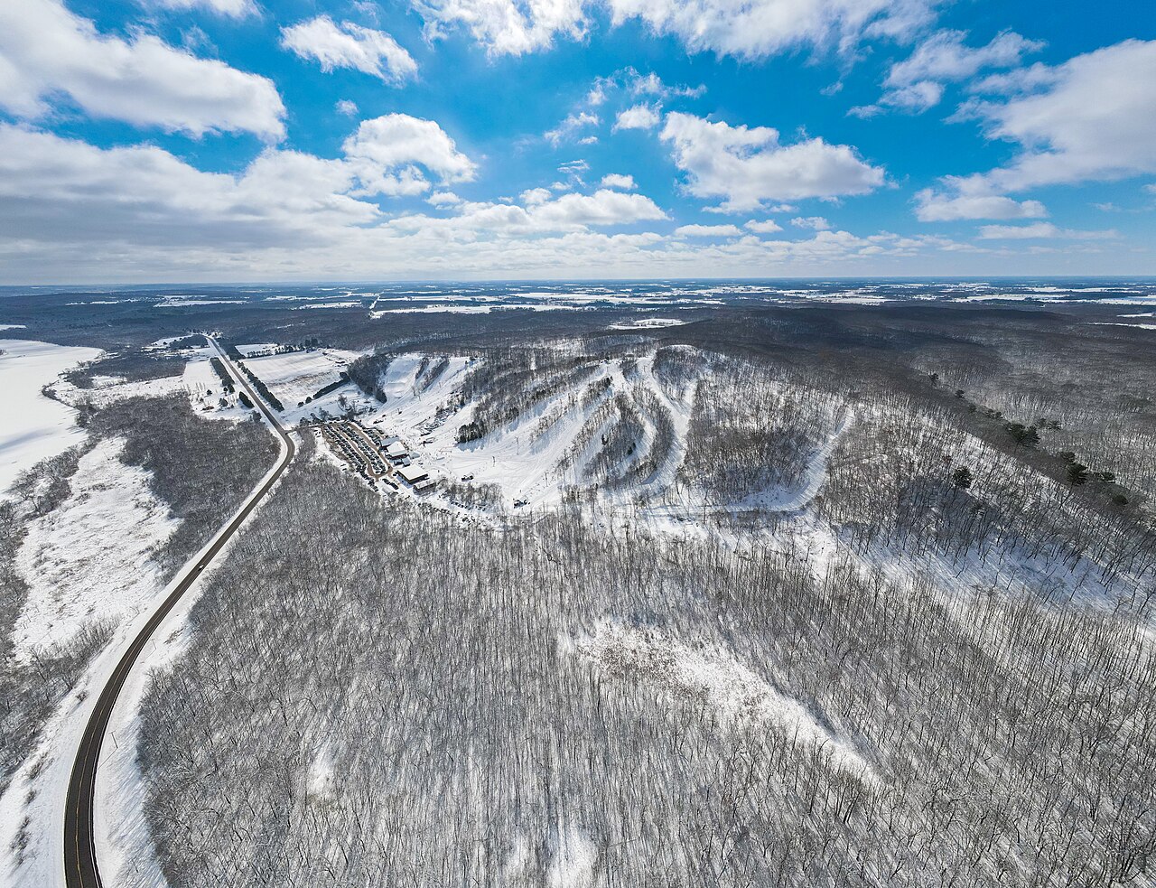
Wild Mountain is a downhill ski area in Minnesota, United States. Mapped terrain includes easy, intermediate, advanced, expert routes. Its mapped lift network extends from approximately 237 to 319 metres above sea level. Cross-country skiing is also mapped within the area.
Data: OpenSkiData / OpenSkiMap, OpenStreetMap contributors (ODbL), Skimap.org, Who's On First, Mapterhorn.
Wild Mountain - Base lift station
ECMWF · Modelllauf: Nächste Aktualisierung erwartet:
Tag Uhrzeit (UTC) Temp. (°C) Luftfeuchtigkeit (%) Wind (km/h) Wind (Knoten) Wind (Bft) Richtung Niederschlag (mm) Neuschnee (cm) Luftdruck (hPa) Nullgradgrenze (m) Wetterlage | Mittwoch, 04/11 06:00 12.9 99 2 1 1B E — — 1000 2966 Overcast 99% cloud 09:00 13.6 98 9 5 2B NE 6.7 0 998 2944 Overcast 95% cloud 12:00 13.8 98 12 6 2B SE 1.7 0 997 2926 Overcast 98% cloud 15:00 13.9 94 12 6 2B S 0.19 0 997 2889 Overcast 100% cloud 18:00 13.1 85 14 7 3B S 0.29 0 997 2875 Overcast 100% cloud 21:00 11.7 92 13 7 3B S 1.1 0 998 2834 Overcast 100% cloud Donnerstag, 05/11 00:00 10.3 96 9 5 2B S 0.93 0 999 2765 Overcast 100% cloud 03:00 9.9 97 5 3 1B W 0.77 0 1001 2732 Overcast 100% cloud 06:00 9.6 96 19 10 3B N 0.93 0 1002 2670 Overcast 100% cloud 09:00 8.9 92 24 13 4B N 0.64 0 1004 2166 Overcast 100% cloud 12:00 8.4 72 22 12 4B N 0.27 0 1008 2235 Overcast 95% cloud 15:00 8.7 65 23 12 4B N 0.02 0 1011 2425 Cloudy 73% cloud 18:00 8.7 64 21 11 4B N 0 0 1014 2992 Overcast 100% cloud 21:00 8.7 59 18 10 3B N 0 0 1016 1182 Overcast 99% cloud Freitag, 06/11 00:00 6.9 60 17 9 3B N 0 0 1019 994 Overcast 92% cloud 03:00 5.3 62 13 7 3B N 0 0 1021 855 Overcast 90% cloud 06:00 3.4 69 10 5 2B NE 0 0 1023 700 Partly cloudy 32% cloud 09:00 1.5 81 7 4 2B N 0 0 1025 536 Clear 9% cloud 12:00 0.1 88 6 3 2B N 0 0 1026 < 297 Clear 2% cloud 15:00 3.1 74 6 3 1B N 0 0 1027 657 Clear 0% cloud 18:00 6.8 54 3 2 1B N 0 0 1026 817 Clear 3% cloud 21:00 7.5 53 5 3 1B NW 0 0 1024 2941 Clear 2% cloud Samstag, 07/11 00:00 4 72 2 1 1B W 0 0 1025 3050 Clear 2% cloud 03:00 2.9 80 3 1 1B S 0 0 1025 3004 Overcast 96% cloud 06:00 1.7 88 6 3 2B SW 0 0 1024 3089 Clear 4% cloud 09:00 2 90 8 4 2B S 0 0 1023 3041 Overcast 96% cloud 12:00 1.1 91 6 3 2B S 0 0 1024 2894 Clear 0% cloud 15:00 4.5 82 12 7 3B S 0 0 1023 2912 Clear 0% cloud 18:00 9.6 60 14 8 3B SW 0 0 1021 3078 Cloudy 57% cloud 21:00 10.9 59 14 8 3B SW 0 0 1019 3072 Partly cloudy 39% cloud Sonntag, 08/11 00:00 7.2 79 11 6 2B SW 0 0 1018 3076 Cloudy 73% cloud 03:00 7.4 82 15 8 3B SW 0 0 1016 3072 Cloudy 77% cloud 06:00 7.8 85 15 8 3B SW 0 0 1016 3066 Overcast 90% cloud 09:00 7 85 13 7 3B W 0 0 1017 3066 Cloudy 78% cloud 12:00 5 88 12 6 2B NW 0 0 1018 3065 Cloudy 64% cloud 15:00 8.2 71 13 7 3B NW 0 0 1020 3073 Clear 11% cloud 18:00 12.4 53 15 8 3B NW 0 0 1020 3081 Partly cloudy 40% cloud 21:00 13.1 50 13 7 3B NW 0 0 1019 3082 Clear 9% cloud Montag, 09/11 00:00 7.2 76 8 4 2B W 0 0 1020 3091 Clear 0% cloud 03:00 5.1 85 5 3 1B W 0 0 1021 3097 Clear 11% cloud 06:00 4 90 1 1 0B S 0 0 1021 3103 Clear 19% cloud 09:00 3.4 94 9 5 2B S 0 0 1020 3102 Partly cloudy 30% cloud 12:00 4 94 13 7 3B S 0 0 1020 3099 Overcast 94% cloud 15:00 7.3 81 15 8 3B S 0 0 1019 3098 Overcast 88% cloud 18:00 13.1 57 16 9 3B SW 0 0 1017 3089 Cloudy 70% cloud 21:00 15.2 60 14 8 3B SW 0 0 1014 3073 Partly cloudy 39% cloud Dienstag, 10/11 00:00 10.7 82 9 5 2B SW 0 0 1014 3068 Overcast 88% cloud 03:00 8.9 87 12 6 2B W 0 0 1014 3049 Overcast 86% cloud 06:00 7.2 83 12 7 2B NW 0 0 1015 2860 Cloudy 61% cloud |
|---|
Forecast notes
Forecast table times: UTC.
Coordinates: 45.4899609°N, -92.706269°E · Requested elevation: 237 m. Model terrain: 295 m. Terrain and 1000/925/850/700 hPa profiles are used for height estimates.
Outside the available profile, temperature uses an estimated 5.5°C/km height correction; wind retains the nearest available model-level value. Humidity is estimated with adjusted pressure and temperature.
These are altitude estimates, not a simulation of local mountain terrain. Precipitation, cloud and sea-level pressure use horizontal interpolation only.
Precipitation includes rain and snow water equivalent: preceding 3 hours through day 6, then 6 hours (see cell tooltip). Snow (cm) estimates fresh snowfall from precipitation and temperature using the GFS conversion; it is not snow depth on the ground. Freezing (m) uses additional 600/500 hPa temperatures when available and estimates the lowest resolved 0°C crossing above sea level. When all sampled levels are warm, the upper profile limit is shown (see tooltip). < marks an entirely cold sampled profile and its lower height limit. No extrapolation is used.
Source: ECMWF · CC BY 4.0 · Processed by Snow Report.
Wild Mountain - Top lift station
ECMWF · Modelllauf: Nächste Aktualisierung erwartet:
Tag Uhrzeit (UTC) Temp. (°C) Luftfeuchtigkeit (%) Wind (km/h) Wind (Knoten) Wind (Bft) Richtung Niederschlag (mm) Neuschnee (cm) Luftdruck (hPa) Nullgradgrenze (m) Wetterlage | Mittwoch, 04/11 06:00 12.5 100 2 1 1B E — — 1000 2966 Overcast 99% cloud 09:00 13.3 99 10 5 2B NE 6.8 0 998 2944 Overcast 95% cloud 12:00 13.4 100 13 7 3B SE 1.6 0 997 2926 Overcast 98% cloud 15:00 13.4 96 12 7 3B S 0.19 0 997 2890 Overcast 100% cloud 18:00 12.5 88 14 8 3B S 0.29 0 997 2874 Overcast 100% cloud 21:00 11.2 94 13 7 3B S 1.1 0 998 2835 Overcast 100% cloud Donnerstag, 05/11 00:00 9.8 97 9 5 2B S 0.93 0 999 2766 Overcast 100% cloud 03:00 9.5 98 5 3 1B W 0.77 0 1001 2732 Overcast 100% cloud 06:00 9.1 97 21 12 4B N 0.93 0 1002 2670 Overcast 100% cloud 09:00 8.4 94 26 14 4B N 0.63 0 1004 2169 Overcast 100% cloud 12:00 7.9 73 24 13 4B N 0.27 0 1008 2234 Overcast 95% cloud 15:00 8.1 67 24 13 4B N 0.02 0 1011 2428 Cloudy 73% cloud 18:00 8.1 66 21 11 4B N 0 0 1014 2992 Overcast 100% cloud 21:00 8.1 61 19 10 3B N 0 0 1016 1183 Overcast 98% cloud Freitag, 06/11 00:00 6.3 61 17 9 3B N 0 0 1019 994 Overcast 92% cloud 03:00 4.8 64 14 8 3B N 0 0 1021 855 Overcast 90% cloud 06:00 2.9 70 10 6 2B NE 0 0 1023 701 Partly cloudy 32% cloud 09:00 1 82 7 4 2B N 0 0 1025 536 Clear 9% cloud 12:00 -0.2 88 6 3 2B N 0 0 1026 < 296 Clear 2% cloud 15:00 2.6 75 6 3 2B NE 0 0 1027 656 Clear 0% cloud 18:00 6.1 56 3 2 1B N 0 0 1026 816 Clear 3% cloud 21:00 6.9 54 5 3 1B NW 0 0 1024 2943 Clear 2% cloud Samstag, 07/11 00:00 3.6 73 2 1 1B W 0 0 1025 3050 Clear 3% cloud 03:00 2.6 80 3 2 1B S 0 0 1025 3005 Overcast 96% cloud 06:00 1.4 87 7 4 2B SW 0 0 1024 3089 Clear 4% cloud 09:00 1.7 90 9 5 2B SW 0 0 1023 3041 Overcast 96% cloud 12:00 0.9 91 6 3 2B S 0 0 1024 2894 Clear 0% cloud 15:00 4.1 82 13 7 3B S 0 0 1023 2912 Clear 0% cloud 18:00 9.1 61 15 8 3B SW 0 0 1021 3078 Cloudy 57% cloud 21:00 10.4 60 15 8 3B SW 0 0 1019 3072 Partly cloudy 39% cloud Sonntag, 08/11 00:00 6.9 79 13 7 3B SW 0 0 1018 3076 Cloudy 73% cloud 03:00 7.3 81 17 9 3B SW 0 0 1016 3072 Cloudy 77% cloud 06:00 7.6 85 17 9 3B W 0 0 1016 3066 Overcast 89% cloud 09:00 6.8 85 14 7 3B W 0 0 1017 3066 Cloudy 79% cloud 12:00 4.9 87 13 7 3B NW 0 0 1018 3066 Cloudy 65% cloud 15:00 7.8 71 14 8 3B NW 0 0 1020 3073 Clear 11% cloud 18:00 11.8 54 16 9 3B NW 0 0 1020 3081 Partly cloudy 39% cloud 21:00 12.5 51 14 8 3B NW 0 0 1019 3082 Clear 9% cloud Montag, 09/11 00:00 6.9 76 8 5 2B NW 0 0 1020 3091 Clear 0% cloud 03:00 4.9 84 5 3 1B W 0 0 1021 3097 Clear 11% cloud 06:00 3.9 88 1 1 1B SW 0 0 1021 3103 Clear 19% cloud 09:00 3.3 93 9 5 2B S 0 0 1020 3102 Partly cloudy 30% cloud 12:00 3.9 92 13 7 3B S 0 0 1020 3099 Overcast 94% cloud 15:00 7.1 79 16 8 3B S 0 0 1019 3098 Overcast 88% cloud 18:00 12.7 58 18 10 3B SW 0 0 1017 3089 Cloudy 70% cloud 21:00 14.7 61 15 8 3B SW 0 0 1014 3073 Partly cloudy 39% cloud Dienstag, 10/11 00:00 10.5 82 11 6 2B SW 0 0 1014 3068 Overcast 87% cloud 03:00 8.7 86 13 7 3B W 0 0 1014 3049 Overcast 86% cloud 06:00 6.9 83 14 8 3B NW 0 0 1015 2860 Cloudy 62% cloud |
|---|
Forecast notes
Forecast table times: UTC.
Coordinates: 45.4883073°N, -92.7113803°E · Requested elevation: 319 m. Model terrain: 293 m. Terrain and 1000/925/850/700 hPa profiles are used for height estimates.
These are altitude estimates, not a simulation of local mountain terrain. Precipitation, cloud and sea-level pressure use horizontal interpolation only.
Precipitation includes rain and snow water equivalent: preceding 3 hours through day 6, then 6 hours (see cell tooltip). Snow (cm) estimates fresh snowfall from precipitation and temperature using the GFS conversion; it is not snow depth on the ground. Freezing (m) uses additional 600/500 hPa temperatures when available and estimates the lowest resolved 0°C crossing above sea level. When all sampled levels are warm, the upper profile limit is shown (see tooltip). < marks an entirely cold sampled profile and its lower height limit. No extrapolation is used.