SNOWREPORT
/
METEOCAM
世界のスキー場の天気予報
GFS・ECMWF・ICON 気象モデル ·
最大16日先までの予報
2,272 スキー場 最新の追加スキー場: Moose Mountain Ski Resort ↗
125 スノーカメラ 最新の追加カメラ: Skeetawk ↗
1996年からの山岳気象の専門知識

- ホーム
-
国
- Albania
- Andorra
- Argentina
- Armenia
- Australia
- Austria
- Azerbaijan
- Belarus
- Belgium
- Bosnia and Herzegovina
- Bulgaria
- Canada
- Chile
- China
- Croatia
- Cyprus
- Czech Republic
- Denmark
- Estonia
- Finland
- France
- Georgia
- Germany
- Greece
- Hong Kong
- Hungary
- Iceland
- Iran
- Israel
- Italy
- Japan
- Kazakhstan
- Kosovo
- Kyrgyzstan
- Latvia
- Lebanon
- Liechtenstein
- Lithuania
- Mauritius
- Montenegro
- Morocco
- Netherlands
- New Zealand
- North Korea
- North Macedonia
- Norway
- Poland
- Portugal
- Romania
- Russia
- Serbia
- Slovakia
- Slovenia
- South Africa
- South Korea
- Spain
- Sweden
- Switzerland
- Turkey
- Ukraine
- United Kingdom
- United States
- Uzbekistan
-
スキー場
- Dolomiti Superski
- Breuil Cervinia
- Alta Badia
- Cortina
- Livigno
- La Thuile ski
- Kronplatz - Plan de Corones
- Monterosa Ski
- Roccaraso - Rivisondoli
- 3 Zinnen Dolomites (Dobbiaco - San Candido - Braies - Sesto - Alta Pusteria)
- Seiser Alm - Mont de Sëuc - Alpe di Siusi
- Sestriere
- Sauze D'Oulx
- Madonna di Campiglio
- Passo Tonale
- Aosta
- Ski Civetta
- Ski Area San Pellegrino - Falcade
- Folgaria
- Arabba
- Riserva Bianca
- Latemar Dolomites
- Courmayeur
- Folgarida
- Canazei
- Gstaad
- Area Sciistica Abetone
- Artesina
- Aprica
- Skiarea Valchiavenna Madesimo/Campodolcino
- Bardonecchia
- Paganella
- Sansicario
- Lagazuoi - 5 Torri
- Sulden
- Schnalstal
- Bormio Ski
- Gitschberg Jochtal
- Speikboden
- Ski Area Alpe Lusia
- San Martino di Castrozza
- Kaunertaler Gletscher
- Schöneben - Belpiano
- Carezza
- Valtournenche
- Tarvisio
- Klausberg - Monte Chiusetta
- Buffaure - Ciampac
- Santa Caterina
- Ratschings-Jaufen
- Cavalese
- Campo Felice
- Crévacol
- Val Comelico - Padola
- Valmalenco Bernina
- Brixen Plose - Plose di Bressanone
- Cima Piazzi – San Colombano
- Brentonico
- Pinzolo
- Prato Nevoso
- Zoncolan
- Bielmonte
- Montecampione
- Frabosa Soprana
- Marmolada
- Bardonecchia - Jafferau
- Skiarea San Domenico
- Sangiacomo Cardini
- Schwemmalm
- Cristallo - Faloria
- Piani di Bobbio - Valtorta Skiarea
- Ovindoli
- Passo Stelvio - Stilfserjoch
- Area Sciistica Ussita Frontignano
- Monte Pora
- Pejo 3000
- Foppolo-Carona
- Meran 2000
- Lurisia Monte Pigna
- Argentera
- Champorcher
- Piancavallo
- Sappada
- Scopello / Alpe di Mera
- Rosskopf
- Reinswald
- Forni di Sopra
- Ski Center Lavarone
- Vigo di Fassa - Ciampedie
- Torgnon
- Area Sciistica Schia Monte Caio
- Rittner Horn - Corno del Renon
- Colere
- Monte Bondone
- Maniva
- Ladurns
- Corno alle Scale
- Campitello Matese
- Crissolo - Monviso Ski
- leMelette
- Borno
- Prali
- Domobianca
- Antagnod
- Cimone
- Pontechianale
- Pescasseroli
- Saint Grée di Viola
- Mottarone
- Alpe del Nevegal
- Nuova Lizzola
- Verena 2000
- Lagorai
- Chamois
- Macugnaga - Moro
- Monte Catria
- Passo Rolle
- Brusson
- Bolognola
- Campo Stella
- Area Sciisitica Febbio - Rescadore
- Piana di Vigezzo
- Etna Nord
- Pfelders
- Campo Staffi
- Spiazzi di Gromo
- Area Sciistica Cerreto Laghi
- Gressoney-Saint-Jean
- Monte Avena
- Campocatino
- Alpe Teglio
- Campo Imperatore
- Sampeyre
- Villaggio Palumbo
- Sarnano - Sassotetto
- Pescegallo
- Prà Alpesina
- Macugnaga - Belvedere
- Gambarie
- Pian Munè
- Cogne
- San Vigilio
- Sellata - Arioso
- Valle Fura
- Area Scistica Zum Zeri
- Etna Sud/Nicolosi
- Jochgrimm
- Doganaccia
- Area Sciistica Pratospilla
- Ala di Stura
- Val d'Aveto
- Sirino Sci
- Trafoi
- Campo di Giove
- Alpe Devero
- Area Sciistica Ventasso Laghi
- Passo Lanciano - Majelletta
- Rucaski
- Selvarotonda
- Piazzatorre Ski Area
- Rein in Taufers - Riva di Tures
- Area Sciistica Piane di Mocogno
- Area Sciistica Sant'Annapelago
- Kaberlaba
- Passo Godi di Scanno
- Biancoia
- Prato Selva
- Prati di Tivo
- Piano Battaglia
- Monte Prata
- Pian delle Betulle
- Presolana
- Mendel
- Passo San Leonardo
- Sauris
- Pian Neiretto
- Val Formazza
- Valgrisenche Ski
- Val Formica
- Villnöß
- Watles
- Selvino
- Forcella Aurine
- Predaia
- Careggine
- Capracotta
- Piani di Artavaggio
- Cheggio
- Monte Carpegna
- Viggiano
- Pragelato
- Alpe Cainallo
- Forca Canapine
- La Pagliara
- Laceno
- Marilleva
- Pian Benot
- Val Gardena
- ルートの天気
- LIVE on the go PILOT
- 気象マップ
- 現在の天気
-
その他
-
人工ゲレンデ
- Kagura Area — Japan (summer)
- Kopaonik — Serbia (summer)
- Nozawa Onsen — Japan (summer)
- CopenHill — Denmark
- Gala Yuzawa Snow Resort — Japan (summer)
- Loisinord - Noeux-les-Mines — France
- Gloucester Ski and Snowboard Centre — United Kingdom
- Pontypool Ski Centre — United Kingdom
- Chatham Snowsports Centre — United Kingdom
- Norfolk Snowsports Club — United Kingdom
- Gosling Ski Centre — United Kingdom
- Liberty Mountain Snowflex Centre — United States
- Llandudno Ski and Snowboard Centre — United Kingdom
- Midlothian Snowsports Centre (Hillend Dry Slope) — United Kingdom
- Plymouth Snowsports Centre — United Kingdom
- Skistar Hammarbybacken — Sweden (summer)
- The Hill - Ski Rossendale — United Kingdom
- Wolfskamer Wintersport — Netherlands
-
風のスポット
- Lake Garda
- Campagnola Reggio Emilia
- Campione Como
- Bibione Veneto
- Bacino della Standiana
- Baia del Silenzio Sestri Levante Liguria
- Albenga Savona
- Arma di Taggia Imperia
- Bientina MeteoBientina Pisa
- Baratti Livorno
- Campo di Mare Roma
- Campomarino Campobasso
- Anzio Levante Lazio
- Barletta-Andria-Trani
- Sardinia Porto Pollo Italy
- Baia Domizia Campani
- Cala Pischina
- Bari Apulia
- Baia San Giorgio Puglia
- Calabria Gizzeria Lido Hang Losse Beach Catanzaro
- Campoformido MeteoBasaldella Friuli-Venezia Giulia
- Bergeggi Volo Arcobaleno Savona
- Bellaria-Igea Marina Rimini
- Andora Savona
- Calambrone Pisa
- Cala della morte
- Canale di Pirro Brindisi e Bari
- Amalfi Salerno
- Alimini di Lecce
-
地点
- Albenga
- Alghero
- Amendola
- Ancona
- Arezzo
- Aviano
- Aviano
- Aviano
- Aviano
- Bari
- Bergamo
- Bologna
- Bolzano
- Bonifati
- Brescia
- Brindisi
- Cagliari
- Calopezzati
- Cameri
- Campobasso
- Campoimperatore
- Cape Bellavista
- Cape Caccia
- Cape Circeo
- Cape Palinuro
- Cape Spartivento
- Capo Carbonara
- Capo Frasca
- Capo Mele
- Capo S. Lorenzo
- Capri Island
- Caraffa Di Catanzar
- Catania
- Catania
- Cervia
- Cisa Pass
- Civitavecchia
- Comiso
- Cozzo Spadaro
- Crotone
- Cuneo
- Decimomannu
- Dobbiaco
- Elba
- Enna
- Ferrara
- Firenze
- Foggia
- Fonni
- Forli
- Forno
- Frontone
- Frosinone
- Gela
- Genova
- Ghedi
- Gioia Del Colle
- Govone
- Gran Sasso Mountain Range
- Grazzanise
- Grigna Settentrion
- Grosseto
- Grottamare
- Guardiavecchia
- Guidonia
- Lamezia Terme
- Lampedusa Island
- Latina
- Latronico
- Lecce
- M. Calamita
- Macomer
- Marina di Campo
- Marina Di Ginosa
- Martina Franca
- Messina
- Milano
- Milano
- Milanoacc/centrocom
- Monte Argentario
- Monte Bisbino
- Monte Calamita
- Monte Cimone
- Monte Grappa
- Monte Malanotte
- Monte Scuro
- Monte Terminillo
- Monte Venda
- Naples
- Napoli
- Napoli
- Olbia
- Padova
- Padova
- Paganella Mountain
- Palascia
- Palermo
- Palermo/
- Palmaria Island
- Pantelleria
- Parma
- Passo Dei Giovi
- Passo Dellaporretta
- Passo Resia
- Passo Rolle
- Perdasdefogu
- Perugia
- Pescara
- Piacenza
- Pian Rosa
- Pisa
- Point Marina
- Ponza Island
- Potenza
- Pratica Di Mare
- Prizzi
- Radiocofani
- Reggio Calabria
- Rieti
- Rimini
- Rivolto
- Roma
- Roma
- Roma
- Salerno
- Sant'Angelo
- Sant?Eufemia Lamezia
- Santa Maria Di Leuc
- Sarzana
- Sciacca
- Siena
- Sigonella
- Taranto
- Tarvisio
- Termoli
- Torino
- Torino
- Torino
- Torre Olevola
- Tortoli'
- Trapani
- Trevico
- Treviso
- Treviso
- Trieste
- Trieste
- Udine
- Ustica Island
- Venezia
- Venezia
- Verona
- Verona
- Vibo Valentia
- Vicenza
- Vieste
- Vigna Di Valle
- Viterbo
- Volterra
- 予報の精度
-
人工ゲレンデ
- ♫ 音声アラート
色の凡例 気温 · 風 · 雨 · 雪
気温 °C
< −10 / −10 / 0 / 10 / 20 / 30+
風速 km/h
< 10 / 10 / 29 / 50 / 75+
雨量 mm
< 1 / 1 / 3 / 10 / 20+
降雪量 cm
< 1 / 1 / 5 / 10 / 20+
各色は表示された値から始まります。風の色は3種類の単位で対応しています。降水のないセルは中立色です。色は表示値を示すもので、公的な気象警報ではありません。
Watles - Base lift station · 1725 m
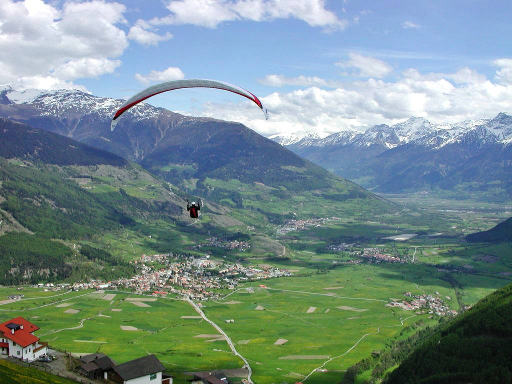
Watles is a mapped downhill ski area in IT. Forecasts cover three real lift-station locations from approximately 1725 to 2495 metres. Elevations are terrain-model estimates.
Data: OpenSkiData / OpenSkiMap, OpenStreetMap contributors (ODbL), Skimap.org, Who's On First, Mapterhorn.
Nearby (straight-line):Schöneben - Belpiano7.1 km NMinschuns16 km SWTrafoi17 km SScuol Motta Naluns20 km NWPasso Stelvio - Stilfserjoch20 km S