SNOWREPORT
METEOCAM
世界のスキー場の天気予報
GFS・ECMWF・ICON 気象モデル
最大16日先までの予報
2,272 スキー場 最新の追加スキー場: Moose Mountain Ski Resort ↗
125 スノーカメラ 最新の追加カメラ: Skeetawk ↗
1996年からの山岳気象の専門知識

色の凡例 気温 · 風 · 雨 · 雪
気温 °C< −10 / −10 / 0 / 10 / 20 / 30+
風速 km/h< 10 / 10 / 29 / 50 / 75+
雨量 mm< 1 / 1 / 3 / 10 / 20+
降雪量 cm< 1 / 1 / 5 / 10 / 20+
各色は表示された値から始まります。風の色は3種類の単位で対応しています。降水のないセルは中立色です。色は表示値を示すもので、公的な気象警報ではありません。
予報グラフを準備中…
時刻と値は詳細予報と一致します。値をタップするかカーソルを合わせると詳細が表示されます。先の日付を見るには各グラフを横にスクロールしてください。雨・降水量は雪を含む各予報時間帯の水換算量です。降雪量は各時間帯の新雪量であり、積雪深ではありません。
GFSとECMWFのモデル比較です。各モデル固有の予報時刻と予報期間を維持しています。降水量と降雪量はそれぞれの予報時間帯の合計であり、時間帯はモデル間で異なる場合があります。
予報値とモデルに関する注記
Verbier - base
ECMWF · モデル計算時刻: 次回更新予定:
日 時刻(UTC) 気温(°C) 湿度(%) 風速(km/h) 風速(ノット) 風(ビューフォート) 風向 降水量(mm) 降雪量(cm) 気圧(hPa) 0°C高度(m) 天気 | 水曜日, 04/11 06:00 1.5 66 3 1 1B SE — — 1021 < 2032 Cloudy 60% cloud  09:00 5.8 55 5 3 1B SE 0 0 1021 2057 Cloudy 63% cloud 12:00 7.4 50 6 3 1B SE 0.07 0 1020 2243 Overcast 99% cloud  15:00 6.5 55 5 3 1B SE 0.21 0 1021 2138 Cloudy 72% cloud 18:00 4.1 62 6 3 2B SE 0.06 0 1022 < 2032 Cloudy 62% cloud 21:00 3.6 63 7 4 2B SE 0 0 1024 < 2032 Cloudy 55% cloud 木曜日, 05/11 00:00 3.7 62 6 3 2B SE 0.01 0 1025 < 2032 Cloudy 80% cloud 03:00 3.6 63 7 4 2B SE 0.01 0 1024 < 2032 Cloudy 70% cloud 06:00 4.1 63 6 3 2B SE 0 0 1024 < 2032 Cloudy 71% cloud 09:00 7.4 56 6 3 2B SE 0.06 0 1025 2400 Cloudy 59% cloud 12:00 9.9 49 5 3 1B SE 0 0 1023 2671 Cloudy 74% cloud 15:00 9.3 52 4 2 1B SE 0 0 1022 2655 Partly cloudy 46% cloud  18:00 5.3 62 4 2 1B SE 0 0 1022 < 2032 Partly cloudy 47% cloud 21:00 5.6 62 4 2 1B SE 0.75 0 1023 < 2032 Cloudy 76% cloud 金曜日, 06/11 00:00 5.4 67 3 2 1B SE 0.06 0 1022 < 2032 Overcast 95% cloud 03:00 5.3 68 3 2 1B SE 0.06 0 1021 < 2032 Overcast 97% cloud 06:00 5.4 68 2 1 1B SE 0.06 0 1020 < 2032 Overcast 89% cloud 09:00 6.8 69 1 1 1B S 0.06 0 1022 2272 Overcast 97% cloud 12:00 6.5 72 1 0 0B S 1.8 0 1021 2209 Overcast 100% cloud 15:00 5.6 75 1 1 1B NW 2.4 0 1022 < 2032 Overcast 100% cloud 18:00 4.4 75 2 1 1B NW 2.2 0 1022 < 2032 Overcast 100% cloud 21:00 4 74 3 1 1B NW 1.6 0 1023 < 2032 Overcast 100% cloud 土曜日, 07/11 00:00 3.8 74 2 1 1B NW 1.4 0 1023 < 2032 Overcast 100% cloud 03:00 3.6 74 1 1 1B NW 0.35 0 1023 < 2032 Overcast 100% cloud 06:00 3.6 74 1 1 0B N 0.13 0 1023 < 2032 Overcast 100% cloud 09:00 5.1 68 1 1 1B SE 0.06 0 1023 < 2032 Cloudy 70% cloud 12:00 6.8 58 1 1 1B SW 0 0 1021 2175 Overcast 84% cloud 15:00 5.9 62 1 1 0B SW 0.14 0 1022 2071 Overcast 95% cloud 18:00 4.3 69 1 0 0B SE 0.24 0 1023 < 2032 Cloudy 69% cloud 21:00 2.5 68 1 1 1B SE 0.06 0 1024 < 2032 Partly cloudy 49% cloud 日曜日, 08/11 00:00 1 63 2 1 1B E 0 0 1024 < 2032 Partly cloudy 49% cloud 03:00 0.4 58 2 1 1B SE 0 0 1023 < 2032 Partly cloudy 38% cloud 06:00 -0.8 61 3 1 1B E 0 0 1023 < 2032 Partly cloudy 43% cloud 09:00 4.8 51 2 1 1B E 0 0 1024 < 2032 Partly cloudy 25% cloud 12:00 7.7 41 0 0 0B S 0 0 1023 2307 Clear 2% cloud  15:00 6.6 40 0 0 0B E 0 0 1021 2191 Clear 7% cloud 18:00 2.9 49 2 1 1B SE 0 0 1021 < 2032 Overcast 82% cloud 21:00 5.8 55 3 1 1B SE 0.07 0 1020 2067 Overcast 100% cloud 月曜日, 09/11 00:00 5.9 57 2 1 1B SE 0 0 1020 2095 Overcast 98% cloud 03:00 5.5 58 3 1 1B SE 0 0 1019 < 2032 Cloudy 67% cloud 06:00 4.9 58 3 2 1B SE 0 0 1019 < 2032 Overcast 83% cloud 09:00 8.9 50 3 2 1B SE 0 0 1019 2643 Overcast 96% cloud 12:00 9.4 53 3 2 1B SE 0.19 0 1018 2724 Overcast 100% cloud 15:00 8.9 57 3 2 1B SE 0.06 0 1017 2749 Overcast 100% cloud 18:00 7.5 62 4 2 1B SE 0.16 0 1017 2710 Overcast 100% cloud 21:00 7.4 63 4 2 1B SE 0 0 1016 3053 Overcast 92% cloud 火曜日, 10/11 00:00 7 64 4 2 1B SE 0 0 1015 3068 Overcast 98% cloud 03:00 7.6 65 4 2 1B E 0 0 1013 3051 Overcast 95% cloud 06:00 7.2 70 4 2 1B SE 1.4 0 1013 3001 Overcast 100% cloud |
|---|
Forecast notes
Forecast table times: UTC.
Coordinates: 46.1°N, 7.2167°E · Requested elevation: 1000 m. Model terrain: 2030 m. Terrain and 1000/925/850/700 hPa profiles are used for height estimates.
Outside the available profile, temperature uses an estimated 5.5°C/km height correction; wind retains the nearest available model-level value. Humidity is estimated with adjusted pressure and temperature.
These are altitude estimates, not a simulation of local mountain terrain. Precipitation, cloud and sea-level pressure use horizontal interpolation only.
Precipitation includes rain and snow water equivalent: preceding 3 hours through day 6, then 6 hours (see cell tooltip). Snow (cm) estimates fresh snowfall from precipitation and temperature using the GFS conversion; it is not snow depth on the ground. Freezing (m) uses additional 600/500 hPa temperatures when available and estimates the lowest resolved 0°C crossing above sea level. When all sampled levels are warm, the upper profile limit is shown (see tooltip). < marks an entirely cold sampled profile and its lower height limit. No extrapolation is used.
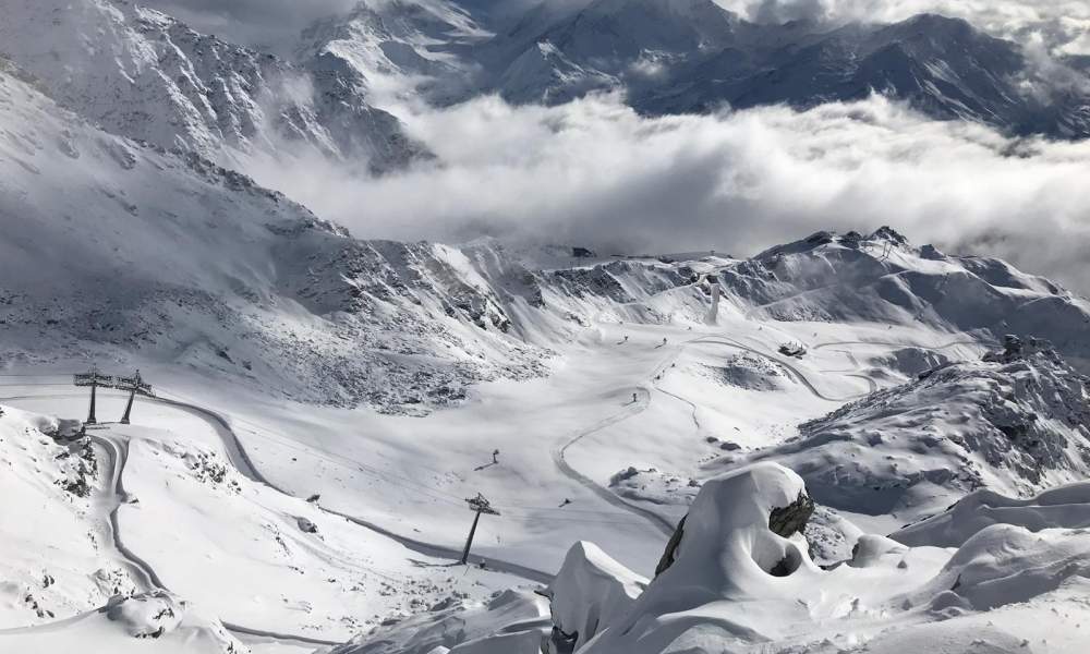
The ski area is divided into four sectors: Medran, Les Savoleyres, Mont Fort and Bruson. Verbier forms the western section of the 4 Valleys ski area. A 4 Valley pass allows a tour all the way from Verbier to La Tzoumaz, Nendaz, Veysonnaz, Les Masses, Thyon and back.
The Verbier section of the 4 Valleys ski area has recent lifts made by Leitner, CWA, Poma and Garaventa AG, all operated by Téléverbier SA. In Verbier alone, there are 35 lifts (within the Verbier, Savoleyeres/La Tzoumaz and Bruson sector). A standard Verbier pass gives access to this entire sector, 33 standard ski runs, two snowparks, one "Jardin de Neige" (a relatively flat area that is used for small children learning to ski), four cross-country pistes and two walking areas.
Resort cameras
Médran · 1,530 m · Live video
Open camera page ↗Les Attelas · 2,700 m · Panorama
Open camera page ↗予報グラフを準備中…
時刻と値は詳細予報と一致します。値をタップするかカーソルを合わせると詳細が表示されます。先の日付を見るには各グラフを横にスクロールしてください。雨・降水量は雪を含む各予報時間帯の水換算量です。降雪量は各時間帯の新雪量であり、積雪深ではありません。
GFSとECMWFのモデル比較です。各モデル固有の予報時刻と予報期間を維持しています。降水量と降雪量はそれぞれの予報時間帯の合計であり、時間帯はモデル間で異なる場合があります。
予報値とモデルに関する注記
Verbier - Middle - Les Ruinettes
ECMWF · モデル計算時刻: 次回更新予定:
日 時刻(UTC) 気温(°C) 湿度(%) 風速(km/h) 風速(ノット) 風(ビューフォート) 風向 降水量(mm) 降雪量(cm) 気圧(hPa) 0°C高度(m) 天気 | 水曜日, 04/11 06:00 -4.6 86 4 2 1B SE — — 1021 < 2099 Cloudy 61% cloud 09:00 -0.9 72 7 4 2B SE 0.00 0 1021 < 2099 Cloudy 65% cloud 12:00 0.4 68 8 5 2B SE 0.08 0 1021 2243 Overcast 99% cloud 15:00 -0.4 74 8 5 2B SE 0.23 0 1021 2139 Cloudy 78% cloud 18:00 -2.3 82 8 4 2B SE 0.08 0 1022 < 2099 Cloudy 68% cloud 21:00 -2.6 82 9 5 2B SE 0 0 1024 < 2099 Cloudy 59% cloud 木曜日, 05/11 00:00 -2.4 81 9 5 2B SE 0 0 1025 < 2099 Overcast 81% cloud 03:00 -2.4 83 10 5 2B SE 0.00 0 1024 < 2099 Cloudy 73% cloud 06:00 -1.9 83 9 5 2B SE 0 0 1024 < 2099 Cloudy 73% cloud 09:00 0.9 74 8 4 2B SE 0.08 0 1025 2375 Cloudy 65% cloud 12:00 3 66 6 3 2B S 0 0 1023 2652 Cloudy 75% cloud 15:00 2.6 68 5 3 1B SE 0 0 1022 2640 Partly cloudy 48% cloud 18:00 -0.9 81 6 3 1B SE 0.00 0 1023 < 2099 Partly cloudy 50% cloud 21:00 -0.4 82 6 3 2B SE 0.90 0.3 1023 < 2099 Cloudy 78% cloud 金曜日, 06/11 00:00 -0.5 87 5 3 1B SE 0.08 0 1022 < 2099 Overcast 96% cloud 03:00 -0.7 90 5 3 1B SE 0.08 0 1021 < 2099 Overcast 98% cloud 06:00 -0.6 90 4 2 1B SE 0.08 0 1020 < 2099 Overcast 90% cloud 09:00 0.4 90 3 2 1B S 0.00 0 1022 2286 Overcast 97% cloud 12:00 0.1 94 3 1 1B S 1.8 0.5 1021 2218 Overcast 100% cloud 15:00 -0.8 98 1 0 0B W 2.5 0.8 1021 < 2099 Overcast 100% cloud 18:00 -2 99 2 1 1B NW 2.2 0.7 1022 < 2099 Overcast 100% cloud 21:00 -2.4 97 3 1 1B NW 1.6 0.5 1023 < 2099 Overcast 100% cloud 土曜日, 07/11 00:00 -2.7 98 2 1 1B NW 1.4 0.4 1023 < 2099 Overcast 100% cloud 03:00 -2.9 98 2 1 1B NW 0.36 0.4 1023 < 2099 Overcast 100% cloud 06:00 -2.9 97 1 1 1B N 0.12 0.1 1023 < 2099 Overcast 100% cloud 09:00 -1.5 90 2 1 1B S 0.08 0 1023 < 2099 Cloudy 69% cloud 12:00 -0.1 79 3 1 1B S 0.00 0 1021 2176 Overcast 84% cloud 15:00 -0.8 83 2 1 1B S 0.17 0 1022 < 2099 Overcast 97% cloud 18:00 -2.3 91 1 1 1B S 0.26 0.1 1023 < 2099 Cloudy 71% cloud 21:00 -3.7 88 1 1 1B S 0.08 0.1 1024 < 2099 Partly cloudy 45% cloud 日曜日, 08/11 00:00 -4.9 80 1 1 1B SE 0 0 1024 < 2099 Partly cloudy 43% cloud 03:00 -5.7 73 2 1 1B S 0 0 1023 < 2099 Partly cloudy 40% cloud 06:00 -6.8 76 2 1 1B SE 0 0 1023 < 2099 Partly cloudy 46% cloud 09:00 -1.8 65 1 0 0B SW 0 0 1024 < 2099 Partly cloudy 26% cloud 12:00 0.8 54 2 1 1B SW 0 0 1023 2298 Clear 3% cloud 15:00 -0.2 53 2 1 1B SW 0 0 1021 2153 Clear 6% cloud 18:00 -3.4 67 2 1 1B S 0 0 1021 < 2099 Overcast 80% cloud 21:00 -0.5 73 3 2 1B S 0.04 0 1020 < 2099 Overcast 100% cloud 月曜日, 09/11 00:00 -0.5 76 2 1 1B S 0.00 0 1020 < 2099 Overcast 98% cloud 03:00 -0.7 77 3 2 1B S 0 0 1019 < 2099 Cloudy 66% cloud 06:00 -1.3 77 3 2 1B S 0 0 1019 < 2099 Overcast 81% cloud 09:00 2.3 67 4 2 1B S 0 0 1019 2637 Overcast 96% cloud 12:00 2.7 72 4 2 1B S 0.20 0 1018 2706 Overcast 100% cloud 15:00 2.4 77 3 2 1B S 0.08 0 1017 2734 Overcast 100% cloud 18:00 1.2 83 5 2 1B S 0.16 0 1017 2676 Overcast 100% cloud 21:00 1.4 84 4 2 1B S 0.00 0 1016 3039 Overcast 91% cloud 火曜日, 10/11 00:00 1.1 85 4 2 1B S 0 0 1015 3068 Overcast 98% cloud 03:00 1.6 85 4 2 1B SE 0 0 1013 3052 Overcast 95% cloud 06:00 1.2 92 4 2 1B S 1.2 0 1013 2977 Overcast 100% cloud |
|---|
Forecast notes
Forecast table times: UTC.
Coordinates: 46.0912007°N, 7.2529037°E · Requested elevation: 2191 m. Model terrain: 2096 m. Terrain and 1000/925/850/700 hPa profiles are used for height estimates.
These are altitude estimates, not a simulation of local mountain terrain. Precipitation, cloud and sea-level pressure use horizontal interpolation only.
Precipitation includes rain and snow water equivalent: preceding 3 hours through day 6, then 6 hours (see cell tooltip). Snow (cm) estimates fresh snowfall from precipitation and temperature using the GFS conversion; it is not snow depth on the ground. Freezing (m) uses additional 600/500 hPa temperatures when available and estimates the lowest resolved 0°C crossing above sea level. When all sampled levels are warm, the upper profile limit is shown (see tooltip). < marks an entirely cold sampled profile and its lower height limit. No extrapolation is used.
予報グラフを準備中…
時刻と値は詳細予報と一致します。値をタップするかカーソルを合わせると詳細が表示されます。先の日付を見るには各グラフを横にスクロールしてください。雨・降水量は雪を含む各予報時間帯の水換算量です。降雪量は各時間帯の新雪量であり、積雪深ではありません。
GFSとECMWFのモデル比較です。各モデル固有の予報時刻と予報期間を維持しています。降水量と降雪量はそれぞれの予報時間帯の合計であり、時間帯はモデル間で異なる場合があります。
予報値とモデルに関する注記
Verbier - Top - Mont Fort
ECMWF · モデル計算時刻: 次回更新予定:
日 時刻(UTC) 気温(°C) 湿度(%) 風速(km/h) 風速(ノット) 風(ビューフォート) 風向 降水量(mm) 降雪量(cm) 気圧(hPa) 0°C高度(m) 天気 | 水曜日, 04/11 06:00 -9 83 14 7 3B SE — — 1021 < 2249 Cloudy 66% cloud 09:00 -8.7 78 22 12 4B SE 0.01 0 1022 < 2249 Cloudy 72% cloud 12:00 -8.6 89 28 15 4B SE 0.11 0.1 1021 < 2249 Overcast 100% cloud 15:00 -8.5 90 31 17 5B SE 0.27 0.3 1022 < 2249 Overcast 81% cloud 18:00 -7.8 83 28 15 4B SE 0.09 0.1 1023 < 2249 Cloudy 73% cloud 21:00 -6.8 75 28 15 4B SE 0 0 1025 < 2249 Cloudy 65% cloud 木曜日, 05/11 00:00 -6.3 77 29 16 4B SE 0 0 1025 < 2249 Overcast 84% cloud 03:00 -5.9 78 32 17 5B SE 0.02 0 1025 < 2249 Cloudy 77% cloud 06:00 -5.5 79 29 16 4B S 0 0 1025 < 2249 Cloudy 76% cloud 09:00 -4.9 79 25 14 4B S 0.08 0.1 1025 2306 Cloudy 74% cloud 12:00 -4.5 77 19 10 3B S 0 0 1024 2613 Cloudy 78% cloud 15:00 -4.1 75 17 9 3B S 0 0 1023 2594 Cloudy 55% cloud 18:00 -3.8 78 16 9 3B SE 0.05 0 1023 < 2249 Cloudy 60% cloud 21:00 -4 90 22 12 4B SE 0.93 0.9 1023 < 2249 Overcast 82% cloud 金曜日, 06/11 00:00 -4 91 22 12 4B SE 0.11 0.1 1022 < 2249 Overcast 97% cloud 03:00 -4.1 92 22 12 4B SE 0.25 0.3 1021 < 2249 Overcast 98% cloud 06:00 -4.4 95 21 11 4B SE 0.13 0.1 1020 < 2249 Overcast 91% cloud 09:00 -5.1 100 20 11 4B SE 0.02 0 1021 2307 Overcast 96% cloud 12:00 -5.5 100 14 7 3B SE 1.6 1.6 1021 < 2249 Overcast 100% cloud 15:00 -6 100 4 2 1B SE 2.3 2.3 1021 < 2249 Overcast 100% cloud 18:00 -6.8 100 5 3 1B NE 2.2 1.7 1022 < 2249 Overcast 100% cloud 21:00 -7.4 100 7 4 2B NE 1.5 1.5 1023 < 2249 Overcast 100% cloud 土曜日, 07/11 00:00 -8 100 5 3 1B NE 1.5 1.5 1023 < 2249 Overcast 100% cloud 03:00 -8.4 100 3 1 1B NE 0.33 0.3 1022 < 2249 Overcast 99% cloud 06:00 -8.7 100 3 2 1B NE 0.16 0.2 1023 < 2249 Overcast 100% cloud 09:00 -8.2 92 6 3 2B SE 0.14 0.1 1023 < 2249 Cloudy 77% cloud 12:00 -8.3 97 10 5 2B S 0.11 0.1 1021 < 2249 Overcast 88% cloud 15:00 -8.4 97 10 6 2B S 0.43 0.4 1022 < 2249 Overcast 97% cloud 18:00 -8.7 96 9 5 2B SW 0.28 0.3 1023 < 2249 Cloudy 73% cloud 21:00 -8.7 75 9 5 2B SW 0.06 0.1 1024 < 2249 Partly cloudy 45% cloud 日曜日, 08/11 00:00 -8.6 54 11 6 2B SW 0 0 1024 < 2249 Partly cloudy 44% cloud 03:00 -8.5 43 12 6 2B SW 0 0 1023 < 2249 Partly cloudy 40% cloud 06:00 -7.9 31 14 7 3B SW 0 0 1023 < 2249 Partly cloudy 42% cloud 09:00 -7.5 31 17 9 3B W 0 0 1024 < 2249 Clear 20% cloud 12:00 -7.2 31 22 12 4B SW 0 0 1023 2258 Clear 3% cloud 15:00 -6.7 45 23 12 4B SW 0 0 1022 < 2249 Clear 5% cloud 18:00 -5.7 87 24 13 4B SW 0 0 1021 < 2249 Cloudy 70% cloud 21:00 -5 97 27 15 4B SW 0.03 0 1021 < 2249 Overcast 100% cloud 月曜日, 09/11 00:00 -5.1 97 24 13 4B SW 0.02 0 1021 < 2249 Overcast 98% cloud 03:00 -4.9 95 25 13 4B SW 0 0 1020 < 2249 Cloudy 66% cloud 06:00 -4.3 87 25 14 4B SW 0 0 1019 < 2249 Cloudy 80% cloud 09:00 -3.8 90 28 15 4B SW 0 0 1019 2578 Overcast 93% cloud 12:00 -3.5 97 28 15 4B SW 0.19 0.2 1019 2679 Overcast 100% cloud 15:00 -3 97 24 13 4B SW 0.14 0.1 1017 2702 Overcast 100% cloud 18:00 -2.5 96 26 14 4B SW 0.17 0 1017 2589 Overcast 100% cloud 21:00 -1.6 95 25 14 4B SW 0.02 0 1017 2947 Overcast 92% cloud 火曜日, 10/11 00:00 -1.4 97 24 13 4B SW 0 0 1016 3068 Overcast 98% cloud 03:00 -1 92 25 14 4B SW 0 0 1014 3052 Overcast 96% cloud 06:00 -1.8 99 22 12 4B SW 1.0 0.3 1013 2887 Overcast 100% cloud |
|---|
Forecast notes
Forecast table times: UTC.
Coordinates: 46.0800833°N, 7.3182579°E · Requested elevation: 3330 m. Model terrain: 2247 m. Terrain and 1000/925/850/700 hPa profiles are used for height estimates.
Outside the available profile, temperature uses an estimated 5.5°C/km height correction; wind retains the nearest available model-level value. Humidity is estimated with adjusted pressure and temperature.
These are altitude estimates, not a simulation of local mountain terrain. Precipitation, cloud and sea-level pressure use horizontal interpolation only.
Precipitation includes rain and snow water equivalent: preceding 3 hours through day 6, then 6 hours (see cell tooltip). Snow (cm) estimates fresh snowfall from precipitation and temperature using the GFS conversion; it is not snow depth on the ground. Freezing (m) uses additional 600/500 hPa temperatures when available and estimates the lowest resolved 0°C crossing above sea level. When all sampled levels are warm, the upper profile limit is shown (see tooltip). < marks an entirely cold sampled profile and its lower height limit. No extrapolation is used.