SNOWREPORT
METEOCAM
Worldwide Ski Resort Forecasts
GFS, ECMWF & ICON weather models
Up to 16-day outlook
2,272 ski resorts Newest resort: Moose Mountain Ski Resort ↗
125 snow cams Newest camera: Skeetawk ↗
Mountain weather expertise since 1996

Remember this location, elevation, model and view in this browser.
Colour guide Temperature · Wind · Rain · Snow
Temperature °C< −10 / −10 / 0 / 10 / 20 / 30+
Wind km/h< 10 / 10 / 29 / 50 / 75+
Rain mm< 1 / 1 / 3 / 10 / 20+
Snow cm< 1 / 1 / 5 / 10 / 20+
Each colour starts at the value shown. Wind colours match across all three units. Dry cells stay neutral. Colours describe the displayed values, not official weather warnings.
Verbier - base
ECMWF · Model run: Next update expected:
Day Time (UTC) Temp. (°C) Humidity (%) Wind (km/h) Wind (knots) Wind (Bft) Direction Precip. (mm) Snow (cm) Pressure (hPa) Freezing (m) Conditions | Sunday, 25/10 06:00 7.3 68 0 0 0B SE — — 1014 2714 Overcast 95% cloud  09:00 9.6 63 1 1 1B W 0.12 0 1014 2928 Overcast 87% cloud 12:00 9.4 67 1 1 1B W 3.2 0 1013 2980 Overcast 100% cloud 15:00 8.4 72 2 1 1B SW 8.6 0 1012 2799 Overcast 100% cloud 18:00 7.5 74 6 3 2B NW 5.1 0 1017 2368 Overcast 99% cloud 21:00 5.1 73 4 2 1B N 0.16 0 1022 < 2032 Overcast 89% cloud Monday, 26/10 00:00 4.1 69 1 1 1B NE 0.06 0 1023 < 2032 Cloudy 76% cloud  03:00 0.2 55 1 1 1B E 0 0 1021 < 2032 Cloudy 58% cloud 06:00 1.9 33 1 1 0B NE 0 0 1020 < 2032 Cloudy 53% cloud 09:00 9.7 30 1 1 0B N 0 0 1020 3172 Overcast 89% cloud 12:00 12.1 24 2 1 1B NW 0 0 1020 3214 Partly cloudy 40% cloud  15:00 11.3 26 1 1 1B N 0 0 1020 3256 Overcast 94% cloud 18:00 9.4 34 1 0 0B E 0 0 1021 3378 Cloudy 71% cloud 21:00 8.3 37 0 0 0B E 0 0 1021 3636 Clear 20% cloud  Tuesday, 27/10 00:00 7.7 42 1 0 0B NE 0 0 1021 3980 Clear 12% cloud 03:00 7.5 46 0 0 0B E 0 0 1020 4091 Partly cloudy 22% cloud 06:00 7.6 48 1 0 0B E 0 0 1020 4078 Clear 0% cloud 09:00 13.9 41 1 0 0B NE 0 0 1020 4108 Clear 13% cloud 12:00 15.9 39 2 1 1B NW 0 0 1020 3939 Clear 5% cloud 15:00 14.5 46 1 1 1B NW 0 0 1020 3763 Partly cloudy 25% cloud 18:00 9 55 1 0 0B N 0 0 1021 3595 Partly cloudy 36% cloud 21:00 8.8 55 1 0 0B N 0 0 1023 3468 Overcast 89% cloud Wednesday, 28/10 00:00 7.8 59 0 0 0B NE 0 0 1024 3323 Overcast 83% cloud 03:00 7.3 58 1 0 0B N 0 0 1023 3176 Cloudy 66% cloud 06:00 5.3 61 1 0 0B N 0 0 1025 < 2032 Clear 2% cloud 09:00 10.1 58 2 1 1B N 0 0 1026 3046 Clear 5% cloud 12:00 11.7 56 2 1 1B NW 0 0 1025 3161 Partly cloudy 31% cloud 15:00 10.6 63 2 1 1B N 0.01 0 1025 3151 Partly cloudy 32% cloud 18:00 5.9 70 1 0 0B E 0 0 1025 3263 Partly cloudy 49% cloud 21:00 3.6 68 1 1 1B E 0 0 1025 2758 Cloudy 64% cloud Thursday, 29/10 00:00 2.8 67 2 1 1B E 0 0 1025 2887 Cloudy 51% cloud 03:00 2.6 64 1 1 1B E 0 0 1024 2939 Partly cloudy 40% cloud 06:00 3.9 53 1 0 0B NE 0 0 1024 2846 Clear 15% cloud 09:00 10.7 42 1 1 1B NE 0 0 1024 3264 Clear 3% cloud 12:00 13.5 33 2 1 1B NW 0 0 1024 3205 Clear 13% cloud 15:00 12.5 34 2 1 1B NW 0 0 1024 3192 Clear 9% cloud 18:00 6.8 44 1 0 0B SE 0 0 1024 3273 Overcast 81% cloud 21:00 6.9 40 0 0 0B E 0 0 1024 3322 Overcast 98% cloud Friday, 30/10 00:00 6.5 39 1 0 0B NE 0 0 1024 3327 Cloudy 74% cloud 03:00 6.3 38 0 0 0B NE 0 0 1024 3256 Clear 16% cloud 06:00 5.6 39 0 0 0B NE 0 0 1024 2068 Clear 2% cloud 09:00 11.8 32 1 0 0B N 0 0 1025 3311 Clear 0% cloud 12:00 13.9 29 2 1 1B NW 0 0 1024 3300 Clear 0% cloud 15:00 12.9 33 2 1 1B NW 0 0 1024 3309 Clear 14% cloud 18:00 7.2 42 1 0 0B E 0 0 1025 3389 Clear 16% cloud 21:00 7 38 1 0 0B E 0 0 1025 3427 Clear 0% cloud Saturday, 31/10 00:00 7.1 35 1 0 0B NE 0 0 1025 3157 Clear 0% cloud 03:00 6.7 34 0 0 0B NE 0 0 1025 3152 Clear 13% cloud 06:00 6.7 32 1 0 0B NE 0 0 1025 3154 Clear 3% cloud |
|---|
Forecast notes
Forecast table times: UTC.
Coordinates: 46.1°N, 7.2167°E · Requested elevation: 1000 m. Model terrain: 2030 m. Terrain and 1000/925/850/700 hPa profiles are used for height estimates.
Outside the available profile, temperature uses an estimated 5.5°C/km height correction; wind retains the nearest available model-level value. Humidity is estimated with adjusted pressure and temperature.
These are altitude estimates, not a simulation of local mountain terrain. Precipitation, cloud and sea-level pressure use horizontal interpolation only.
Precipitation includes rain and snow water equivalent: preceding 3 hours through day 6, then 6 hours (see cell tooltip). Snow (cm) estimates fresh snowfall from precipitation and temperature using the GFS conversion; it is not snow depth on the ground. Freezing (m) uses additional 600/500 hPa temperatures when available and estimates the lowest resolved 0°C crossing above sea level. When all sampled levels are warm, the upper profile limit is shown (see tooltip). < marks an entirely cold sampled profile and its lower height limit. No extrapolation is used.
Source: ECMWF · CC BY 4.0 · Processed by Snow Report.
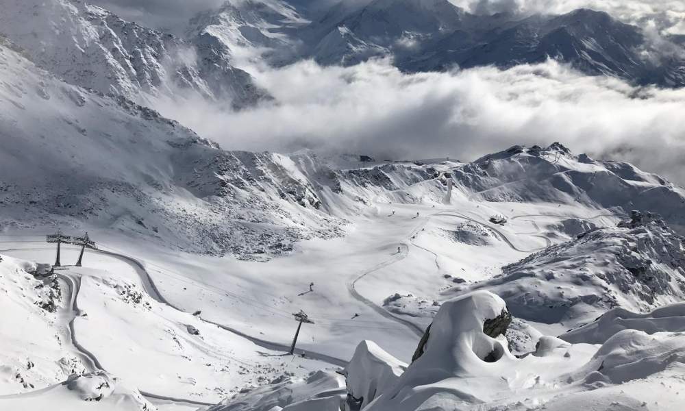
The ski area is divided into four sectors: Medran, Les Savoleyres, Mont Fort and Bruson. Verbier forms the western section of the 4 Valleys ski area. A 4 Valley pass allows a tour all the way from Verbier to La Tzoumaz, Nendaz, Veysonnaz, Les Masses, Thyon and back.
The Verbier section of the 4 Valleys ski area has recent lifts made by Leitner, CWA, Poma and Garaventa AG, all operated by Téléverbier SA. In Verbier alone, there are 35 lifts (within the Verbier, Savoleyeres/La Tzoumaz and Bruson sector). A standard Verbier pass gives access to this entire sector, 33 standard ski runs, two snowparks, one "Jardin de Neige" (a relatively flat area that is used for small children learning to ski), four cross-country pistes and two walking areas.
Resort cameras
Médran · 1,530 m · Live video
Open camera page ↗Les Attelas · 2,700 m · Panorama
Open camera page ↗Verbier - Middle - Les Ruinettes
ECMWF · Model run: Next update expected:
Day Time (UTC) Temp. (°C) Humidity (%) Wind (km/h) Wind (knots) Wind (Bft) Direction Precip. (mm) Snow (cm) Pressure (hPa) Freezing (m) Conditions | Sunday, 25/10 06:00 1.3 89 4 2 1B W — — 1014 2709 Overcast 94% cloud 09:00 3.3 81 6 3 2B W 0.11 0 1014 2926 Overcast 86% cloud 12:00 3.1 88 7 4 2B W 3.0 0 1013 2978 Overcast 100% cloud 15:00 2.1 94 7 4 2B W 8.6 0 1012 2787 Overcast 100% cloud 18:00 0.9 94 10 5 2B NW 5.2 1.6 1017 2364 Overcast 100% cloud 21:00 -1.4 91 7 4 2B NW 0.17 0 1022 < 2099 Overcast 87% cloud Monday, 26/10 00:00 -2.1 85 3 2 1B NW 0.08 0 1023 < 2099 Overcast 80% cloud 03:00 -5.6 65 2 1 1B N 0 0 1021 < 2099 Cloudy 56% cloud 06:00 -3.8 39 2 1 1B NW 0 0 1020 < 2099 Partly cloudy 47% cloud 09:00 3.5 36 2 1 1B NW 0 0 1020 3172 Overcast 88% cloud 12:00 5.6 30 3 2 1B NW 0 0 1020 3213 Partly cloudy 39% cloud 15:00 4.8 32 2 1 1B NW 0 0 1020 3251 Overcast 93% cloud 18:00 3.4 46 2 1 1B NW 0 0 1021 3372 Cloudy 71% cloud 21:00 2.5 52 2 1 1B N 0 0 1021 3626 Partly cloudy 22% cloud Tuesday, 27/10 00:00 2.1 57 2 1 1B N 0 0 1021 3973 Clear 12% cloud 03:00 2 60 1 1 1B N 0 0 1020 4092 Partly cloudy 23% cloud 06:00 2.1 60 1 1 0B N 0 0 1020 4081 Clear 0% cloud 09:00 7.7 51 1 0 0B NW 0 0 1020 4112 Clear 13% cloud 12:00 9.3 50 3 1 1B NW 0 0 1020 3947 Clear 3% cloud 15:00 7.9 57 2 1 1B NW 0 0 1020 3770 Partly cloudy 27% cloud 18:00 3 68 2 1 1B NW 0 0 1021 3603 Partly cloudy 30% cloud 21:00 2.8 67 1 1 1B NW 0 0 1023 3474 Overcast 88% cloud Wednesday, 28/10 00:00 1.8 73 1 1 1B NW 0 0 1024 3326 Overcast 81% cloud 03:00 1.2 72 1 1 1B NW 0 0 1023 3183 Cloudy 69% cloud 06:00 -0.7 78 1 1 1B N 0 0 1025 < 2099 Clear 2% cloud 09:00 3.6 73 2 1 1B NW 0 0 1026 3042 Clear 2% cloud 12:00 5.1 70 2 1 1B NW 0 0 1025 3154 Partly cloudy 26% cloud 15:00 4.1 76 2 1 1B N 0 0 1025 3140 Partly cloudy 26% cloud 18:00 -0.3 85 1 0 0B NE 0 0 1025 2525 Partly cloudy 41% cloud 21:00 -2.4 82 1 1 1B E 0 0 1025 2857 Cloudy 65% cloud Thursday, 29/10 00:00 -3.2 82 1 1 1B E 0 0 1024 2950 Cloudy 52% cloud 03:00 -3.3 78 1 0 0B NE 0 0 1024 2983 Partly cloudy 40% cloud 06:00 -1.9 65 1 1 1B N 0 0 1024 2905 Clear 12% cloud 09:00 4.3 52 2 1 1B N 0 0 1024 3263 Clear 2% cloud 12:00 6.7 41 2 1 1B NW 0 0 1024 3205 Clear 13% cloud 15:00 5.9 41 2 1 1B NW 0 0 1024 3189 Clear 10% cloud 18:00 0.7 51 1 0 0B NE 0 0 1024 3271 Overcast 80% cloud 21:00 0.9 46 1 1 1B NE 0 0 1024 3321 Overcast 98% cloud Friday, 30/10 00:00 0.6 46 1 1 1B NE 0 0 1024 3323 Cloudy 73% cloud 03:00 0.3 44 1 1 1B N 0 0 1024 3255 Clear 15% cloud 06:00 -0.3 45 2 1 1B N 0 0 1024 2617 Clear 0% cloud 09:00 5.2 38 2 1 1B N 0 0 1025 3307 Clear 0% cloud 12:00 7.2 35 3 1 1B N 0 0 1024 3291 Clear 0% cloud 15:00 6.2 40 2 1 1B N 0 0 1024 3301 Clear 13% cloud 18:00 1.1 49 2 1 1B NE 0 0 1025 3384 Clear 16% cloud 21:00 1 44 2 1 1B NE 0 0 1025 3425 Clear 0% cloud Saturday, 31/10 00:00 1.2 41 2 1 1B NE 0 0 1025 3156 Clear 0% cloud 03:00 0.9 40 2 1 1B N 0 0 1025 3152 Clear 12% cloud 06:00 1 37 3 2 1B N 0 0 1025 3154 Clear 3% cloud |
|---|
Forecast notes
Forecast table times: UTC.
Coordinates: 46.0912007°N, 7.2529037°E · Requested elevation: 2191 m. Model terrain: 2096 m. Terrain and 1000/925/850/700 hPa profiles are used for height estimates.
These are altitude estimates, not a simulation of local mountain terrain. Precipitation, cloud and sea-level pressure use horizontal interpolation only.
Precipitation includes rain and snow water equivalent: preceding 3 hours through day 6, then 6 hours (see cell tooltip). Snow (cm) estimates fresh snowfall from precipitation and temperature using the GFS conversion; it is not snow depth on the ground. Freezing (m) uses additional 600/500 hPa temperatures when available and estimates the lowest resolved 0°C crossing above sea level. When all sampled levels are warm, the upper profile limit is shown (see tooltip). < marks an entirely cold sampled profile and its lower height limit. No extrapolation is used.
Source: ECMWF · CC BY 4.0 · Processed by Snow Report.
Verbier - Top - Mont Fort
ECMWF · Model run: Next update expected:
Day Time (UTC) Temp. (°C) Humidity (%) Wind (km/h) Wind (knots) Wind (Bft) Direction Precip. (mm) Snow (cm) Pressure (hPa) Freezing (m) Conditions | Sunday, 25/10 06:00 -2.3 100 40 22 6B W — — 1014 2716 Overcast 95% cloud 09:00 -2.1 83 43 23 6B W 0.10 0 1013 2939 Overcast 83% cloud 12:00 -1.8 100 56 30 7B W 2.7 0.8 1013 2979 Overcast 100% cloud 15:00 -2.4 100 54 29 7B W 8.3 3.3 1012 2815 Overcast 100% cloud 18:00 -5.1 70 42 22 6B W 5.1 5.1 1017 2382 Overcast 99% cloud 21:00 -7.2 50 31 17 5B NW 0.19 0.2 1022 < 2249 Overcast 87% cloud Monday, 26/10 00:00 -5.9 30 31 17 5B NW 0.07 0.1 1023 < 2249 Overcast 82% cloud 03:00 -3.7 19 26 14 4B NW 0 0 1021 < 2249 Cloudy 53% cloud 06:00 -2.3 14 22 12 4B NW 0 0 1020 < 2249 Partly cloudy 38% cloud 09:00 -0.9 10 20 11 4B NW 0 0 1020 3162 Overcast 88% cloud 12:00 -0.7 13 18 10 3B W 0 0 1020 3213 Partly cloudy 38% cloud 15:00 -0.6 21 21 11 4B W 0 0 1020 3244 Overcast 84% cloud 18:00 -0.3 64 22 12 4B NW 0 0 1021 3362 Cloudy 74% cloud 21:00 0.5 79 17 9 3B NW 0 0 1021 3601 Partly cloudy 27% cloud Tuesday, 27/10 00:00 2.2 69 15 8 3B NW 0 0 1021 3967 Clear 13% cloud 03:00 3.4 54 13 7 3B NW 0 0 1020 4090 Partly cloudy 24% cloud 06:00 4 37 9 5 2B NW 0 0 1020 4086 Clear 0% cloud 09:00 4.8 30 7 4 2B W 0 0 1020 4118 Clear 13% cloud 12:00 3.8 47 12 6 2B W 0 0 1020 3956 Clear 2% cloud 15:00 2.8 46 13 7 3B NW 0 0 1020 3783 Partly cloudy 25% cloud 18:00 1.8 48 11 6 2B NW 0 0 1021 3620 Partly cloudy 26% cloud 21:00 0.8 51 10 5 2B W 0 0 1023 3476 Overcast 87% cloud Wednesday, 28/10 00:00 -0 49 12 7 3B W 0 0 1024 3324 Cloudy 79% cloud 03:00 -0.7 48 11 6 2B NW 0 0 1023 2433 Cloudy 70% cloud 06:00 -1.5 62 10 5 2B NW 0 0 1025 < 2249 Clear 5% cloud 09:00 -1.4 52 6 3 2B NW 0 0 1025 3031 Clear 2% cloud 12:00 -1.1 42 5 3 1B NW 0 0 1025 3140 Clear 18% cloud 15:00 -1.2 35 2 1 1B N 0 0 1025 3108 Partly cloudy 20% cloud 18:00 -0.6 36 3 2 1B N 0 0 1025 2939 Partly cloudy 30% cloud 21:00 -0.1 28 2 1 1B N 0 0 1025 2968 Cloudy 67% cloud Thursday, 29/10 00:00 -0.3 30 4 2 1B W 0 0 1024 3024 Cloudy 50% cloud 03:00 -0.5 29 6 3 2B NW 0 0 1024 3028 Partly cloudy 36% cloud 06:00 -0.5 26 9 5 2B NW 0 0 1024 2991 Clear 10% cloud 09:00 -0.3 25 8 4 2B N 0 0 1024 3258 Clear 2% cloud 12:00 -0.8 28 7 4 2B N 0 0 1024 3195 Clear 14% cloud 15:00 -0.9 29 6 3 2B NW 0 0 1024 3179 Clear 13% cloud 18:00 -0.4 24 7 4 2B N 0 0 1025 2672 Cloudy 79% cloud 21:00 0 21 8 4 2B N 0 0 1024 2462 Overcast 99% cloud Friday, 30/10 00:00 0 22 7 4 2B N 0 0 1024 2578 Cloudy 69% cloud 03:00 -0.4 25 10 5 2B N 0 0 1024 2786 Clear 14% cloud 06:00 -0.7 27 13 7 3B N 0 0 1024 2973 Clear 0% cloud 09:00 -0 20 14 7 3B N 0 0 1025 3297 Clear 0% cloud 12:00 -0.2 21 13 7 3B NE 0 0 1024 3279 Clear 0% cloud 15:00 -0.1 23 12 7 2B NE 0 0 1024 3289 Clear 14% cloud 18:00 0.4 21 17 9 3B NE 0 0 1025 2283 Clear 16% cloud 21:00 0.8 19 18 10 3B N 0 0 1025 2296 Clear 0% cloud Saturday, 31/10 00:00 0.6 22 18 10 3B N 0 0 1025 3156 Clear 0% cloud 03:00 0.7 22 19 10 3B N 0 0 1025 2407 Clear 12% cloud 06:00 0.9 21 22 12 4B N 0 0 1025 2369 Clear 5% cloud |
|---|
Forecast notes
Forecast table times: UTC.
Coordinates: 46.0800833°N, 7.3182579°E · Requested elevation: 3330 m. Model terrain: 2247 m. Terrain and 1000/925/850/700 hPa profiles are used for height estimates.
Outside the available profile, temperature uses an estimated 5.5°C/km height correction; wind retains the nearest available model-level value. Humidity is estimated with adjusted pressure and temperature.
These are altitude estimates, not a simulation of local mountain terrain. Precipitation, cloud and sea-level pressure use horizontal interpolation only.
Precipitation includes rain and snow water equivalent: preceding 3 hours through day 6, then 6 hours (see cell tooltip). Snow (cm) estimates fresh snowfall from precipitation and temperature using the GFS conversion; it is not snow depth on the ground. Freezing (m) uses additional 600/500 hPa temperatures when available and estimates the lowest resolved 0°C crossing above sea level. When all sampled levels are warm, the upper profile limit is shown (see tooltip). < marks an entirely cold sampled profile and its lower height limit. No extrapolation is used.