Seceda · Val Gardena · Panorama

Provider panorama/video player. Capture time is shown by the camera.
Open camera page ↗
Chaque couleur commence à la valeur indiquée. Les couleurs du vent correspondent dans les trois unités. Les cases sans précipitations restent neutres. Les couleurs décrivent les valeurs affichées et ne sont pas des alertes officielles.
ECMWF · Cycle du modèle : Prochaine mise à jour attendue :
Jour Heure (UTC) Temp. (°C) Humidité (%) Vent (km/h) Vent (nœuds) Vent (Bft) Direction Précip. (mm) Neige fraîche (cm) Pression (hPa) Isotherme 0 °C (m) Conditions | Mercredi, 04/11 06:00 2.7 80 2 1 1B E — — 1024 1734 Cloudy 69% cloud  09:00 5.7 64 2 1 1B SE 0.01 0 1025 2115 Overcast 82% cloud  12:00 6.9 58 2 1 1B SE 0.04 0 1025 2223 Overcast 87% cloud 15:00 5.9 64 2 1 1B SE 0.02 0 1025 2205 Overcast 80% cloud 18:00 2.9 75 1 0 0B SE 0 0 1026 1808 Overcast 81% cloud 21:00 1.5 76 1 1 1B SE 0.03 0 1028 < 1691 Partly cloudy 39% cloud  Jeudi, 05/11 00:00 1.2 76 0 0 0B E 0 0 1028 < 1691 Partly cloudy 38% cloud 03:00 0.9 75 1 0 0B E 0 0 1028 < 1691 Partly cloudy 24% cloud 06:00 0.6 74 0 0 0B E 0 0 1028 < 1691 Clear 4% cloud  09:00 6.5 54 1 1 0B SW 0 0 1028 2622 Clear 1% cloud 12:00 9.1 49 3 2 1B SW 0 0 1026 2775 Clear 0% cloud 15:00 7.2 63 1 1 0B W 0 0 1025 2886 Clear 0% cloud 18:00 2.9 70 0 0 0B E 0 0 1026 2305 Clear 0% cloud 21:00 2.4 70 0 0 0B E 0 0 1026 < 1691 Clear 0% cloud Vendredi, 06/11 00:00 2.3 67 0 0 0B E 0 0 1025 < 1691 Clear 0% cloud 03:00 2.4 64 1 0 0B E 0 0 1024 < 1691 Clear 0% cloud 06:00 2.5 63 0 0 0B S 0 0 1023 < 1691 Clear 0% cloud 09:00 8.3 47 1 1 1B SW 0 0 1022 2930 Clear 7% cloud 12:00 10.9 44 2 1 1B SW 0 0 1020 2940 Clear 6% cloud 15:00 8.2 60 1 1 0B SW 0 0 1019 2789 Partly cloudy 27% cloud 18:00 3.6 72 1 1 1B SE 0 0 1020 2173 Overcast 82% cloud 21:00 3.8 74 1 1 1B SE 0 0 1021 2093 Overcast 99% cloud Samedi, 07/11 00:00 3.8 74 1 1 1B E 0.09 0 1022 2004 Overcast 97% cloud 03:00 2.9 72 1 0 0B E 0.09 0 1021 1800 Cloudy 75% cloud 06:00 2.7 69 1 1 0B S 0.07 0 1023 1731 Overcast 91% cloud 09:00 4.5 68 2 1 1B E 0.77 0 1024 2029 Overcast 99% cloud 12:00 5.8 64 2 1 1B E 0.47 0 1023 2153 Overcast 95% cloud 15:00 4.9 65 1 1 1B SE 0.20 0 1023 2063 Overcast 96% cloud 18:00 3.5 74 2 1 1B SE 0.17 0 1024 1869 Overcast 99% cloud 21:00 3 75 1 1 1B E 0.26 0 1025 1787 Overcast 97% cloud Dimanche, 08/11 00:00 2.6 75 1 0 0B E 0.14 0 1025 1706 Overcast 98% cloud 03:00 1.9 77 1 1 0B SE 0.24 0 1025 < 1691 Overcast 98% cloud 06:00 2.3 77 1 1 0B S 0.24 0 1025 < 1691 Overcast 100% cloud 09:00 3.9 74 3 1 1B SW 0.06 0 1026 1886 Overcast 92% cloud 12:00 5.6 63 4 2 1B SW 0.13 0 1025 2076 Cloudy 71% cloud 15:00 4.8 68 3 1 1B SW 0.02 0 1024 2025 Cloudy 61% cloud 18:00 0.8 80 1 1 1B SE 0 0 1026 < 1691 Cloudy 59% cloud 21:00 -1 81 1 1 1B SE 0 0 1026 < 1691 Cloudy 62% cloud Lundi, 09/11 00:00 -2.1 81 1 1 1B E 0 0 1026 < 1691 Partly cloudy 41% cloud 03:00 -0.5 75 1 0 0B E 0 0 1025 < 1691 Cloudy 77% cloud 06:00 0.3 72 1 0 0B SE 0 0 1025 < 1691 Cloudy 76% cloud 09:00 4.8 60 3 1 1B SW 0 0 1025 2420 Cloudy 62% cloud 12:00 6.9 57 4 2 1B SW 0 0 1022 2609 Partly cloudy 42% cloud 15:00 5.1 70 4 2 1B SW 0 0 1022 2414 Overcast 87% cloud 18:00 2.3 80 2 1 1B S 0 0 1022 < 1691 Overcast 93% cloud 21:00 4 80 2 1 1B S 0 0 1022 2213 Overcast 100% cloud Mardi, 10/11 00:00 3.9 83 1 1 1B S 0.08 0 1021 2265 Overcast 99% cloud 03:00 4 84 2 1 1B S 0.04 0 1019 2435 Overcast 100% cloud 06:00 4.3 84 1 1 0B SE 0 0 1018 2517 Overcast 100% cloud |
|---|
Forecast table times: UTC.
Coordinates: 46.57219672°N, 11.6709137°E · Requested elevation: 1235 m. Model terrain: 1689 m. Terrain and 1000/925/850/700 hPa profiles are used for height estimates.
Outside the available profile, temperature uses an estimated 5.5°C/km height correction; wind retains the nearest available model-level value. Humidity is estimated with adjusted pressure and temperature.
These are altitude estimates, not a simulation of local mountain terrain. Precipitation, cloud and sea-level pressure use horizontal interpolation only.
Precipitation includes rain and snow water equivalent: preceding 3 hours through day 6, then 6 hours (see cell tooltip). Snow (cm) estimates fresh snowfall from precipitation and temperature using the GFS conversion; it is not snow depth on the ground. Freezing (m) uses additional 600/500 hPa temperatures when available and estimates the lowest resolved 0°C crossing above sea level. When all sampled levels are warm, the upper profile limit is shown (see tooltip). < marks an entirely cold sampled profile and its lower height limit. No extrapolation is used.
Source: ECMWF · CC BY 4.0 · Processed by Snow Report.
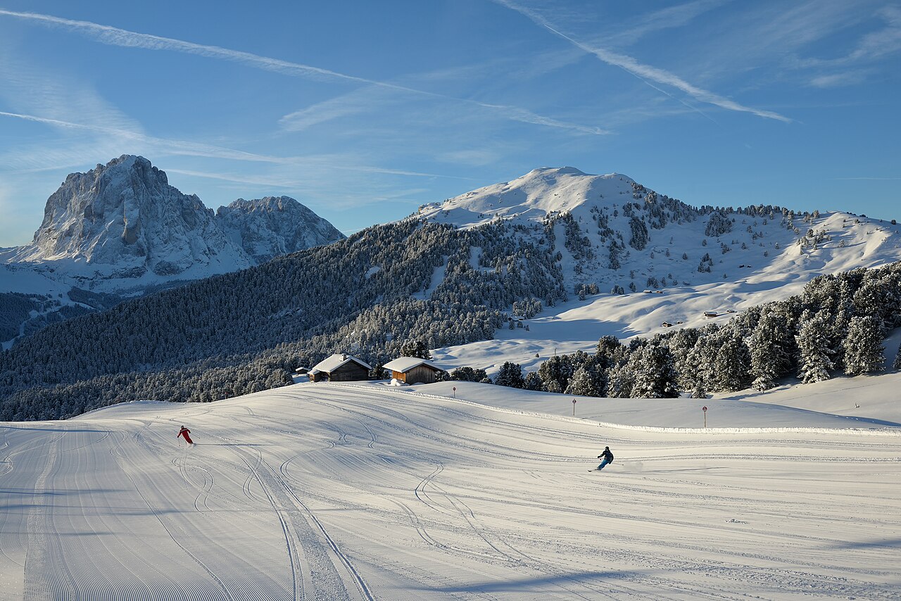
Val Gardena offre plusieurs départs pour une journée dans les Dolomites. Ortisei donne accès à Seceda et à l’Alpe di Siusi, tandis que Santa Cristina et Selva desservent d’autres secteurs. Depuis Seceda, La Longia est une longue piste rouge descendant vers Ortisei ; elle ne se confond pas avec le circuit Sellaronda autour du massif du Sella.
Les itinéraires officiels sont utiles car certains parcours ne se composent pas uniquement de pistes et de remontées. La Val Gardena Ronda comprend un transfert en ski-bus entre Saltria et Monte Pana. Vérifiez donc les transports et le retour autant que la distance. Le bulletin en direct distingue aussi les deux sens de la Sellaronda.
Notre point sélectionné est à 1 235 m, près de l’altitude d’Ortisei plutôt que des pistes supérieures. Pour skier à Seceda, choisissez un point plus haut et gardez la prévision basse pour le retour. Sur une longue descente, le changement de température entre matin et après-midi compte également. Le cumul de neige d’une altitude ne s’applique pas tel quel à toute la vallée.
Sources officielles: Val Gardena ski itineraries · Seceda — winter · Val Gardena open slopes. Informations vérifiées le 18 octobre 2026.
Provider panorama/video player. Capture time is shown by the camera.
Open camera page ↗ECMWF · Cycle du modèle : Prochaine mise à jour attendue :
Jour Heure (UTC) Temp. (°C) Humidité (%) Vent (km/h) Vent (nœuds) Vent (Bft) Direction Précip. (mm) Neige fraîche (cm) Pression (hPa) Isotherme 0 °C (m) Conditions | Mercredi, 04/11 06:00 -0.7 91 3 2 1B SE — — 1024 1742 Cloudy 67% cloud 09:00 1.9 74 4 2 1B SE 0.00 0 1025 2122 Overcast 83% cloud 12:00 2.9 68 4 2 1B SE 0.04 0 1025 2224 Overcast 89% cloud 15:00 2.2 74 4 2 1B S 0.02 0 1025 2203 Cloudy 79% cloud 18:00 -0.3 83 3 2 1B S 0 0 1027 1795 Overcast 81% cloud 21:00 -1.5 83 3 1 1B S 0.03 0 1028 < 1696 Partly cloudy 41% cloud Jeudi, 05/11 00:00 -1.6 81 2 1 1B S 0 0 1028 < 1696 Partly cloudy 40% cloud 03:00 -1.8 78 2 1 1B S 0 0 1028 < 1696 Partly cloudy 25% cloud 06:00 -2 77 2 1 1B S 0 0 1028 < 1696 Clear 4% cloud 09:00 3.2 59 3 2 1B SW 0 0 1028 2624 Clear 1% cloud 12:00 5.5 55 5 2 1B SW 0 0 1026 2772 Clear 0% cloud 15:00 3.9 67 2 1 1B SW 0 0 1025 2880 Clear 0% cloud 18:00 0.3 73 1 1 1B S 0 0 1026 2289 Clear 0% cloud 21:00 -0.2 72 1 1 1B S 0 0 1026 < 1696 Clear 0% cloud Vendredi, 06/11 00:00 -0.2 71 2 1 1B S 0 0 1025 < 1696 Clear 0% cloud 03:00 -0.1 67 2 1 1B S 0 0 1023 < 1696 Clear 0% cloud 06:00 -0 67 2 1 1B S 0 0 1023 1818 Clear 0% cloud 09:00 5 52 3 2 1B S 0 0 1022 2929 Clear 8% cloud 12:00 7.2 49 4 2 1B SW 0 0 1020 2939 Clear 7% cloud 15:00 4.6 66 3 1 1B S 0 0 1019 2785 Partly cloudy 27% cloud 18:00 0.7 78 3 2 1B SE 0 0 1020 2182 Overcast 84% cloud 21:00 0.8 79 5 3 1B SE 0 0 1021 2104 Overcast 99% cloud Samedi, 07/11 00:00 0.5 81 6 3 1B SE 0.09 0 1021 2009 Overcast 97% cloud 03:00 -0.3 78 5 3 1B SE 0.09 0 1021 1807 Cloudy 76% cloud 06:00 -0.6 77 5 3 1B SE 0.07 0 1023 1743 Overcast 92% cloud 09:00 0.9 78 6 3 2B SE 0.82 0.2 1024 2023 Overcast 99% cloud 12:00 2 74 4 2 1B SE 0.48 0 1023 2155 Overcast 95% cloud 15:00 1.2 77 3 1 1B S 0.22 0 1023 2057 Overcast 97% cloud 18:00 -0.1 86 3 2 1B SE 0.17 0 1024 1862 Overcast 99% cloud 21:00 -0.5 87 2 1 1B S 0.28 0.1 1025 1783 Overcast 97% cloud Dimanche, 08/11 00:00 -0.9 87 2 1 1B S 0.16 0 1025 1708 Overcast 98% cloud 03:00 -1.5 89 3 1 1B S 0.26 0.1 1025 < 1696 Overcast 99% cloud 06:00 -1.3 89 3 2 1B SW 0.25 0 1025 < 1696 Overcast 100% cloud 09:00 0.1 85 5 2 1B SW 0.06 0 1026 1886 Overcast 92% cloud 12:00 1.6 73 5 3 1B SW 0.13 0 1025 2074 Cloudy 69% cloud 15:00 1 77 4 2 1B W 0.02 0 1024 2020 Cloudy 61% cloud 18:00 -2.2 85 1 1 1B W 0 0 1026 < 1696 Cloudy 61% cloud 21:00 -3.7 84 1 1 1B W 0 0 1026 < 1696 Cloudy 63% cloud Lundi, 09/11 00:00 -4.5 84 1 1 1B W 0 0 1026 < 1696 Partly cloudy 41% cloud 03:00 -3.1 79 2 1 1B SW 0 0 1025 < 1696 Cloudy 76% cloud 06:00 -2.3 78 2 1 1B W 0 0 1025 < 1696 Cloudy 77% cloud 09:00 1.8 67 5 3 1B SW 0 0 1025 2424 Cloudy 62% cloud 12:00 3.5 64 7 4 2B SW 0 0 1022 2605 Partly cloudy 42% cloud 15:00 1.9 77 7 4 2B SW 0 0 1022 2412 Overcast 88% cloud 18:00 -0.5 89 5 3 1B SW 0 0 1022 < 1696 Overcast 94% cloud 21:00 1 90 7 4 2B SW 0 0 1022 2218 Overcast 100% cloud Mardi, 10/11 00:00 1 93 6 3 2B SW 0.08 0 1021 2272 Overcast 99% cloud 03:00 1.2 94 6 3 1B SW 0.03 0 1019 2442 Overcast 100% cloud 06:00 1.4 94 5 3 1B SW 0 0 1018 2524 Overcast 100% cloud |
|---|
Forecast table times: UTC.
Coordinates: 46.55956851°N, 11.66524887°E · Requested elevation: 1874 m. Model terrain: 1693 m. Terrain and 1000/925/850/700 hPa profiles are used for height estimates.
These are altitude estimates, not a simulation of local mountain terrain. Precipitation, cloud and sea-level pressure use horizontal interpolation only.
Precipitation includes rain and snow water equivalent: preceding 3 hours through day 6, then 6 hours (see cell tooltip). Snow (cm) estimates fresh snowfall from precipitation and temperature using the GFS conversion; it is not snow depth on the ground. Freezing (m) uses additional 600/500 hPa temperatures when available and estimates the lowest resolved 0°C crossing above sea level. When all sampled levels are warm, the upper profile limit is shown (see tooltip). < marks an entirely cold sampled profile and its lower height limit. No extrapolation is used.
Source: ECMWF · CC BY 4.0 · Processed by Snow Report.
ECMWF · Cycle du modèle : Prochaine mise à jour attendue :
Jour Heure (UTC) Temp. (°C) Humidité (%) Vent (km/h) Vent (nœuds) Vent (Bft) Direction Précip. (mm) Neige fraîche (cm) Pression (hPa) Isotherme 0 °C (m) Conditions | Mercredi, 04/11 06:00 -4.2 87 9 5 2B SE — — 1024 1730 Partly cloudy 50% cloud 09:00 -3 82 11 6 2B SE 0.00 0 1025 2127 Cloudy 75% cloud 12:00 -2.4 80 11 6 2B SE 0.02 0 1024 2225 Overcast 95% cloud 15:00 -2.1 79 10 6 2B S 0.04 0 1025 2198 Cloudy 71% cloud 18:00 -2.8 76 10 5 2B S 0 0 1026 1843 Cloudy 78% cloud 21:00 -2.9 65 11 6 2B S 0.08 0.1 1028 < 1493 Cloudy 62% cloud Jeudi, 05/11 00:00 -2.5 61 10 5 2B S 0 0 1028 < 1493 Cloudy 63% cloud 03:00 -2.3 54 12 6 2B S 0 0 1028 < 1493 Partly cloudy 37% cloud 06:00 -1.9 53 12 6 2B S 0 0 1028 < 1493 Clear 6% cloud 09:00 0.4 52 13 7 3B SW 0 0 1028 2609 Clear 1% cloud 12:00 1.3 52 12 7 3B SW 0 0 1026 2750 Clear 0% cloud 15:00 1.4 50 8 4 2B SW 0 0 1026 2873 Clear 0% cloud 18:00 0.1 51 6 3 1B S 0 0 1026 2572 Clear 0% cloud 21:00 -0.2 52 8 4 2B S 0 0 1026 2248 Clear 0% cloud Vendredi, 06/11 00:00 -0.1 53 9 5 2B S 0 0 1025 2301 Clear 0% cloud 03:00 -0.1 51 9 5 2B S 0 0 1024 2415 Clear 0% cloud 06:00 -0.3 53 9 5 2B S 0 0 1024 2222 Clear 0% cloud 09:00 1.7 49 11 6 2B S 0 0 1023 2910 Clear 8% cloud 12:00 2.5 48 12 6 2B S 0 0 1020 2919 Clear 10% cloud 15:00 1.2 57 10 5 2B S 0 0 1020 2764 Partly cloudy 27% cloud 18:00 -0.5 63 11 6 2B SE 0 0 1020 2359 Overcast 93% cloud 21:00 -1.3 60 18 10 3B SE 0 0 1021 2160 Overcast 99% cloud Samedi, 07/11 00:00 -2.1 70 25 14 4B SE 0.04 0 1021 2020 Overcast 93% cloud 03:00 -2.7 66 23 12 4B SE 0.12 0 1021 1853 Overcast 87% cloud 06:00 -3.7 80 21 11 4B SE 0.17 0.2 1023 1779 Overcast 98% cloud 09:00 -3.2 89 21 12 4B SE 1.2 1.2 1024 1965 Overcast 100% cloud 12:00 -2.6 89 11 6 2B SE 0.44 0.1 1023 2140 Overcast 98% cloud 15:00 -3.1 93 8 4 2B S 0.44 0.4 1023 2025 Overcast 99% cloud 18:00 -3.6 95 8 4 2B S 0.15 0.2 1024 1867 Overcast 100% cloud 21:00 -3.9 93 8 4 2B S 0.40 0.4 1025 1805 Overcast 98% cloud Dimanche, 08/11 00:00 -4.3 94 8 4 2B S 0.41 0.4 1025 1747 Overcast 99% cloud 03:00 -4.8 94 11 6 2B SW 0.40 0.4 1025 1625 Overcast 100% cloud 06:00 -5.1 94 11 6 2B SW 0.20 0.2 1025 1627 Overcast 100% cloud 09:00 -4.6 92 11 6 2B SW 0.09 0.1 1026 1850 Overcast 84% cloud 12:00 -3.6 78 11 6 2B W 0.13 0.1 1025 2056 Cloudy 54% cloud 15:00 -3.4 70 12 6 2B W 0.00 0 1025 2011 Cloudy 57% cloud 18:00 -3.9 57 10 6 2B W 0 0 1026 < 1493 Cloudy 62% cloud 21:00 -4.1 55 11 6 2B W 0 0 1026 < 1493 Cloudy 76% cloud Lundi, 09/11 00:00 -4 50 12 6 2B W 0 0 1026 < 1493 Cloudy 55% cloud 03:00 -3 58 12 7 2B SW 0 0 1025 < 1493 Cloudy 77% cloud 06:00 -2.3 62 13 7 3B W 0 0 1025 < 1493 Overcast 85% cloud 09:00 -0.2 61 16 9 3B W 0 0 1025 2456 Cloudy 66% cloud 12:00 0.3 62 18 10 3B SW 0 0 1023 2587 Partly cloudy 47% cloud 15:00 -0.2 69 22 12 4B W 0 0 1022 2477 Overcast 91% cloud 18:00 -1.3 85 22 12 4B SW 0 0 1022 1986 Overcast 95% cloud 21:00 -0.7 89 27 14 4B SW 0 0 1022 2304 Overcast 100% cloud Mardi, 10/11 00:00 -0.4 91 29 16 5B SW 0.04 0 1021 2376 Overcast 98% cloud 03:00 0 88 26 14 4B W 0.01 0 1019 2524 Overcast 99% cloud 06:00 0.2 91 26 14 4B SW 0 0 1018 2600 Overcast 99% cloud |
|---|
Forecast table times: UTC.
Coordinates: 46.51091656°N, 11.57546997°E · Requested elevation: 2518 m. Model terrain: 1490 m. Terrain and 1000/925/850/700 hPa profiles are used for height estimates.
These are altitude estimates, not a simulation of local mountain terrain. Precipitation, cloud and sea-level pressure use horizontal interpolation only.
Precipitation includes rain and snow water equivalent: preceding 3 hours through day 6, then 6 hours (see cell tooltip). Snow (cm) estimates fresh snowfall from precipitation and temperature using the GFS conversion; it is not snow depth on the ground. Freezing (m) uses additional 600/500 hPa temperatures when available and estimates the lowest resolved 0°C crossing above sea level. When all sampled levels are warm, the upper profile limit is shown (see tooltip). < marks an entirely cold sampled profile and its lower height limit. No extrapolation is used.