Wettervorhersagen für Skigebiete weltweit

Farbskala Temperatur · Wind · Regen · Schnee
Jede Farbe beginnt beim angegebenen Wert. Die Windfarben stimmen in allen drei Einheiten überein. Trockene Zellen bleiben neutral. Die Farben beschreiben die Werte und sind keine amtlichen Wetterwarnungen.
Diagramme werden vorbereitet…
Zeiten und Werte entsprechen der detaillierten Vorhersage. Tippen Sie auf einen Wert für Details und scrollen Sie seitlich für spätere Tage. Niederschlag ist das gesamte Wasseräquivalent je Intervall einschließlich Schnee. Neuschnee gilt je Intervall und ist keine Schneehöhe am Boden.
Vergleich von GFS und ECMWF. Jedes Modell behält seine eigenen Vorhersagezeiten und seinen Zeitraum. Niederschlags- und Schneemengen gelten für die jeweiligen, möglicherweise unterschiedlichen Intervalle.
Vorhersagewerte und Modellhinweise
Tambara Ski Park - Low lift station
ECMWF · Modelllauf: Nächste Aktualisierung erwartet:
Tag Uhrzeit (UTC) Temp. (°C) Luftfeuchtigkeit (%) Wind (km/h) Wind (Knoten) Wind (Bft) Richtung Niederschlag (mm) Neuschnee (cm) Luftdruck (hPa) Nullgradgrenze (m) Wetterlage | Mittwoch, 04/11 06:00 6.9 82 15 8 3B S — — 1029 3115 Overcast 100% cloud  09:00 5.6 93 15 8 3B S 0.39 0 1029 3154 Overcast 99% cloud 12:00 5.4 98 20 11 4B S 0.94 0 1029 3149 Overcast 100% cloud 15:00 5.8 96 13 7 3B SE 4.6 0 1027 3131 Overcast 100% cloud 18:00 6.2 97 15 8 3B SE 4.6 0 1024 3120 Overcast 100% cloud 21:00 7.2 95 13 7 3B SE 4.7 0 1022 3116 Overcast 100% cloud Donnerstag, 05/11 00:00 9.1 94 10 6 2B SE 0.40 0 1019 3106 Overcast 97% cloud 03:00 11.1 86 9 5 2B S 0.08 0 1014 3078 Overcast 90% cloud 06:00 12.3 79 11 6 2B W 0 0 1011 3054 Cloudy 79% cloud  09:00 9 92 6 3 2B W 0 0 1010 3045 Cloudy 59% cloud 12:00 7.6 95 7 4 2B W 0.04 0 1008 3034 Cloudy 76% cloud 15:00 7 91 5 3 1B W 0.08 0 1006 3018 Partly cloudy 48% cloud  18:00 6.8 88 9 5 2B W 0.01 0 1004 3000 Partly cloudy 44% cloud 21:00 6.9 95 12 6 2B NW 0.60 0 1006 2997 Overcast 81% cloud Freitag, 06/11 00:00 9.9 85 20 11 4B NW 1.0 0 1008 3008 Overcast 85% cloud 03:00 11.5 63 21 11 4B NW 0.49 0 1008 2992 Partly cloudy 44% cloud 06:00 10.9 64 14 7 3B NW 0.14 0 1008 2822 Partly cloudy 41% cloud 09:00 7.7 84 12 6 2B NW 0.17 0 1012 2667 Cloudy 72% cloud 12:00 6.5 83 12 7 2B NW 0.22 0 1013 2370 Cloudy 62% cloud 15:00 4.7 85 20 11 4B NW 0.90 0 1015 2073 Overcast 94% cloud 18:00 2.5 86 21 11 4B NW 1.6 0 1016 1698 Overcast 97% cloud 21:00 1.8 84 21 11 4B NW 0.87 0 1018 1526 Overcast 97% cloud Samstag, 07/11 00:00 1.2 87 26 14 4B NW 0.99 0 1021 1383 Overcast 94% cloud 03:00 1.6 78 35 19 5B NW 1.1 0 1021 1389 Overcast 81% cloud 06:00 0.7 82 37 20 5B NW 1.1 0.3 1023 1321 Overcast 91% cloud 09:00 -0.5 88 39 21 5B NW 1.2 0.4 1026 1184 Overcast 87% cloud 12:00 -1.1 83 36 20 5B NW 0.37 0.1 1028 1122 Overcast 81% cloud 15:00 -1.2 83 33 18 5B NW 0.15 0 1029 1075 Cloudy 77% cloud 18:00 -1 86 33 18 5B NW 0.29 0.1 1030 1107 Overcast 97% cloud 21:00 -1 89 27 15 4B NW 0.28 0.1 1031 1121 Overcast 96% cloud Sonntag, 08/11 00:00 0.8 78 24 13 4B NW 0.33 0.1 1032 1325 Overcast 95% cloud 03:00 1.9 76 25 14 4B NW 0.37 0 1032 1421 Overcast 93% cloud 06:00 1.9 72 19 10 3B N 0.18 0 1031 1475 Overcast 92% cloud 09:00 0.9 73 9 5 2B N 0.01 0 1032 1498 Overcast 93% cloud 12:00 0.4 76 2 1 1B NW 0.01 0 1033 1495 Cloudy 78% cloud 15:00 -0.3 79 4 2 1B NW 0 0 1031 < 980 Overcast 89% cloud 18:00 0.5 77 6 3 2B NW 0 0 1030 1577 Overcast 95% cloud 21:00 1.1 76 4 2 1B NW 0.04 0 1029 1851 Overcast 90% cloud Montag, 09/11 00:00 4 65 6 3 1B SW 0 0 1027 2026 Cloudy 76% cloud 03:00 5.9 64 4 2 1B SW 0 0 1023 2183 Cloudy 59% cloud 06:00 5.2 75 12 6 2B N 0.01 0 1022 1939 Overcast 97% cloud 09:00 3.4 82 9 5 2B N 0.00 0 1023 1916 Partly cloudy 45% cloud 12:00 2.3 89 13 7 3B NW 0.39 0 1024 1741 Cloudy 68% cloud 15:00 0.7 88 25 14 4B N 0.90 0.3 1024 1354 Overcast 83% cloud 18:00 -1 88 35 19 5B NW 1.0 0.3 1024 1105 Overcast 95% cloud 21:00 -1.3 89 34 18 5B NW 0.66 0.2 1025 1078 Overcast 94% cloud Dienstag, 10/11 00:00 -0.7 87 26 14 4B NW 0.91 0.3 1026 1170 Overcast 89% cloud 03:00 -0.2 81 20 11 4B NW 0.79 0.2 1026 1224 Overcast 80% cloud 06:00 -0.5 77 17 9 3B NW 0.33 0.1 1027 1196 Cloudy 64% cloud |
|---|
Forecast notes
Forecast table times: UTC.
Coordinates: 36.7792768°N, 139.073272°E · Requested elevation: 1243 m. Model terrain: 978 m. Terrain and 1000/925/850/700 hPa profiles are used for height estimates.
These are altitude estimates, not a simulation of local mountain terrain. Precipitation, cloud and sea-level pressure use horizontal interpolation only.
Precipitation includes rain and snow water equivalent: preceding 3 hours through day 6, then 6 hours (see cell tooltip). Snow (cm) estimates fresh snowfall from precipitation and temperature using the GFS conversion; it is not snow depth on the ground. Freezing (m) uses additional 600/500 hPa temperatures when available and estimates the lowest resolved 0°C crossing above sea level. When all sampled levels are warm, the upper profile limit is shown (see tooltip). < marks an entirely cold sampled profile and its lower height limit. No extrapolation is used.
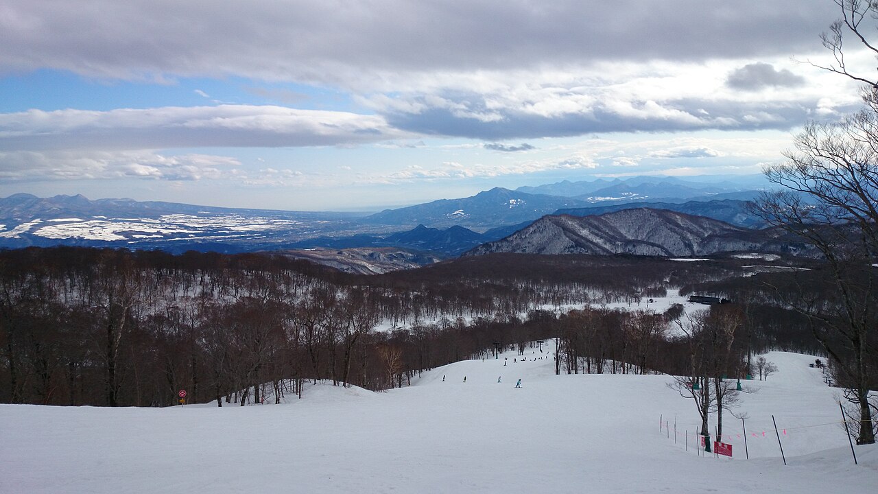
Tambara Ski Park is a downhill ski area in Gunma Prefecture, Japan. Mapped terrain includes easy, intermediate, advanced routes. Its mapped lift network extends from approximately 1243 to 1556 metres above sea level.
Data: OpenSkiData / OpenSkiMap, OpenStreetMap contributors (ODbL), Skimap.org, Who's On First, Mapterhorn.
Diagramme werden vorbereitet…
Zeiten und Werte entsprechen der detaillierten Vorhersage. Tippen Sie auf einen Wert für Details und scrollen Sie seitlich für spätere Tage. Niederschlag ist das gesamte Wasseräquivalent je Intervall einschließlich Schnee. Neuschnee gilt je Intervall und ist keine Schneehöhe am Boden.
Vergleich von GFS und ECMWF. Jedes Modell behält seine eigenen Vorhersagezeiten und seinen Zeitraum. Niederschlags- und Schneemengen gelten für die jeweiligen, möglicherweise unterschiedlichen Intervalle.
Vorhersagewerte und Modellhinweise
Tambara Ski Park - Base lift station
ECMWF · Modelllauf: Nächste Aktualisierung erwartet:
Tag Uhrzeit (UTC) Temp. (°C) Luftfeuchtigkeit (%) Wind (km/h) Wind (Knoten) Wind (Bft) Richtung Niederschlag (mm) Neuschnee (cm) Luftdruck (hPa) Nullgradgrenze (m) Wetterlage | Mittwoch, 04/11 06:00 6.5 83 16 9 3B S — — 1028 3109 Overcast 100% cloud 09:00 5.4 93 17 9 3B S 0.39 0 1029 3154 Overcast 99% cloud 12:00 5.2 98 23 13 4B S 0.95 0 1029 3149 Overcast 100% cloud 15:00 5.7 96 15 8 3B SE 4.6 0 1027 3131 Overcast 100% cloud 18:00 6.1 96 18 9 3B SE 4.6 0 1024 3120 Overcast 100% cloud 21:00 7.1 95 16 8 3B SE 4.8 0 1022 3116 Overcast 100% cloud Donnerstag, 05/11 00:00 8.9 93 12 7 3B SE 0.41 0 1018 3106 Overcast 96% cloud 03:00 10.8 87 10 5 2B SE 0.07 0 1014 3078 Overcast 90% cloud 06:00 12 79 12 7 3B W 0 0 1011 3054 Cloudy 79% cloud 09:00 8.8 92 8 4 2B W 0 0 1010 3045 Cloudy 59% cloud 12:00 7.5 95 8 4 2B W 0.04 0 1008 3034 Cloudy 77% cloud 15:00 6.9 91 6 3 2B W 0.07 0 1006 3017 Partly cloudy 47% cloud 18:00 6.7 87 10 5 2B W 0.01 0 1004 3000 Partly cloudy 43% cloud 21:00 6.6 95 13 7 3B NW 0.62 0 1006 2997 Overcast 80% cloud Freitag, 06/11 00:00 9.6 84 21 11 4B NW 1.1 0 1008 3008 Overcast 86% cloud 03:00 11 63 22 12 4B NW 0.53 0 1008 2989 Partly cloudy 44% cloud 06:00 10.4 64 15 8 3B NW 0.15 0 1008 2822 Partly cloudy 42% cloud 09:00 7.3 84 13 7 3B NW 0.20 0 1012 2662 Cloudy 73% cloud 12:00 6.1 83 13 7 3B NW 0.26 0 1014 2364 Cloudy 64% cloud 15:00 4.3 85 21 11 4B NW 0.98 0 1015 2066 Overcast 94% cloud 18:00 2.1 86 22 12 4B NW 1.7 0 1016 1691 Overcast 97% cloud 21:00 1.3 85 23 12 4B NW 0.94 0 1018 1518 Overcast 97% cloud Samstag, 07/11 00:00 0.6 88 29 16 5B NW 1.1 0.3 1021 1380 Overcast 94% cloud 03:00 0.9 80 38 21 5B NW 1.2 0.4 1021 1387 Overcast 81% cloud 06:00 0.1 83 41 22 6B NW 1.2 0.4 1023 1318 Overcast 91% cloud 09:00 -1 89 43 23 6B NW 1.3 0.4 1026 1180 Overcast 87% cloud 12:00 -1.6 84 40 22 6B NW 0.39 0.1 1028 1120 Overcast 81% cloud 15:00 -1.6 84 36 20 5B NW 0.17 0 1029 1071 Cloudy 78% cloud 18:00 -1.5 87 37 20 5B NW 0.31 0.1 1030 1106 Overcast 97% cloud 21:00 -1.4 90 31 17 5B NW 0.30 0.1 1031 1121 Overcast 96% cloud Sonntag, 08/11 00:00 0.2 81 26 14 4B NW 0.36 0.1 1033 1324 Overcast 95% cloud 03:00 1.3 78 27 14 4B NW 0.39 0 1032 1422 Overcast 93% cloud 06:00 1.4 73 20 11 4B NW 0.19 0 1031 1473 Overcast 92% cloud 09:00 0.6 72 9 5 2B N 0.02 0 1032 1484 Overcast 94% cloud 12:00 0.2 75 2 1 1B NW 0.01 0 1033 1458 Cloudy 79% cloud 15:00 -0.3 78 4 2 1B W 0 0 1031 < 999 Overcast 89% cloud 18:00 0.4 77 6 3 2B NW 0 0 1030 1569 Overcast 95% cloud 21:00 1 75 4 2 1B W 0.04 0 1029 1844 Overcast 91% cloud Montag, 09/11 00:00 3.6 66 6 3 2B SW 0 0 1027 2025 Cloudy 76% cloud 03:00 5.4 64 5 2 1B W 0 0 1023 2185 Cloudy 58% cloud 06:00 4.5 77 13 7 3B N 0.01 0 1022 1940 Overcast 97% cloud 09:00 3.1 82 9 5 2B NW 0.01 0 1023 1911 Partly cloudy 47% cloud 12:00 2 88 14 7 3B NW 0.42 0 1024 1736 Cloudy 69% cloud 15:00 0.3 88 27 15 4B NW 0.93 0.3 1024 1350 Overcast 83% cloud 18:00 -1.5 87 38 20 5B NW 1.1 0.3 1025 1105 Overcast 95% cloud 21:00 -1.8 89 37 20 5B NW 0.66 0.2 1025 1077 Overcast 94% cloud Dienstag, 10/11 00:00 -1.3 88 29 16 5B NW 0.91 0.3 1026 1172 Overcast 89% cloud 03:00 -0.8 82 22 12 4B NW 0.79 0.2 1026 1227 Overcast 81% cloud 06:00 -1 78 18 10 3B NW 0.34 0.1 1027 1197 Cloudy 63% cloud |
|---|
Forecast notes
Forecast table times: UTC.
Coordinates: 36.7837914°N, 139.0805028°E · Requested elevation: 1305 m. Model terrain: 996 m. Terrain and 1000/925/850/700 hPa profiles are used for height estimates.
These are altitude estimates, not a simulation of local mountain terrain. Precipitation, cloud and sea-level pressure use horizontal interpolation only.
Precipitation includes rain and snow water equivalent: preceding 3 hours through day 6, then 6 hours (see cell tooltip). Snow (cm) estimates fresh snowfall from precipitation and temperature using the GFS conversion; it is not snow depth on the ground. Freezing (m) uses additional 600/500 hPa temperatures when available and estimates the lowest resolved 0°C crossing above sea level. When all sampled levels are warm, the upper profile limit is shown (see tooltip). < marks an entirely cold sampled profile and its lower height limit. No extrapolation is used.
Diagramme werden vorbereitet…
Zeiten und Werte entsprechen der detaillierten Vorhersage. Tippen Sie auf einen Wert für Details und scrollen Sie seitlich für spätere Tage. Niederschlag ist das gesamte Wasseräquivalent je Intervall einschließlich Schnee. Neuschnee gilt je Intervall und ist keine Schneehöhe am Boden.
Vergleich von GFS und ECMWF. Jedes Modell behält seine eigenen Vorhersagezeiten und seinen Zeitraum. Niederschlags- und Schneemengen gelten für die jeweiligen, möglicherweise unterschiedlichen Intervalle.
Vorhersagewerte und Modellhinweise
Tambara Ski Park - Top lift station
ECMWF · Modelllauf: Nächste Aktualisierung erwartet:
Tag Uhrzeit (UTC) Temp. (°C) Luftfeuchtigkeit (%) Wind (km/h) Wind (Knoten) Wind (Bft) Richtung Niederschlag (mm) Neuschnee (cm) Luftdruck (hPa) Nullgradgrenze (m) Wetterlage | Mittwoch, 04/11 06:00 4.7 89 21 11 4B S — — 1028 3102 Overcast 100% cloud 09:00 4.5 91 28 15 4B S 0.38 0 1029 3154 Overcast 99% cloud 12:00 4.5 96 37 20 5B S 0.97 0 1029 3149 Overcast 100% cloud 15:00 5.1 94 27 14 4B SE 4.5 0 1026 3131 Overcast 100% cloud 18:00 5.7 95 29 16 5B SE 4.6 0 1024 3120 Overcast 100% cloud 21:00 7 92 26 14 4B SE 5.0 0 1021 3116 Overcast 100% cloud Donnerstag, 05/11 00:00 8.2 91 19 10 3B SE 0.43 0 1018 3106 Overcast 96% cloud 03:00 9.4 89 13 7 3B S 0.06 0 1014 3078 Overcast 91% cloud 06:00 10.8 79 18 10 3B W 0 0 1011 3054 Cloudy 79% cloud 09:00 8 91 14 7 3B W 0 0 1010 3045 Cloudy 57% cloud 12:00 6.9 93 15 8 3B W 0.06 0 1008 3034 Cloudy 77% cloud 15:00 6.3 90 11 6 2B W 0.06 0 1006 3017 Partly cloudy 46% cloud 18:00 6.1 86 18 10 3B W 0.01 0 1004 3000 Partly cloudy 41% cloud 21:00 5.7 95 18 10 3B NW 0.66 0 1006 2997 Overcast 80% cloud Freitag, 06/11 00:00 8.1 81 27 15 4B NW 1.3 0 1008 3007 Overcast 87% cloud 03:00 9.3 62 29 16 5B NW 0.61 0 1008 2981 Partly cloudy 45% cloud 06:00 8.7 65 23 12 4B W 0.16 0 1008 2820 Partly cloudy 44% cloud 09:00 5.9 83 19 10 3B W 0.25 0 1012 2651 Cloudy 73% cloud 12:00 4.6 83 19 10 3B W 0.33 0 1014 2353 Cloudy 66% cloud 15:00 2.8 84 26 14 4B W 1.1 0 1015 2053 Overcast 94% cloud 18:00 0.6 84 28 15 4B NW 1.9 0.6 1017 1678 Overcast 97% cloud 21:00 -0.3 85 31 17 5B NW 1.1 0.3 1018 1505 Overcast 97% cloud Samstag, 07/11 00:00 -1.4 89 42 23 6B NW 1.2 0.4 1021 1374 Overcast 94% cloud 03:00 -1.6 84 51 28 7B NW 1.4 0.4 1021 1382 Overcast 82% cloud 06:00 -2 85 57 31 7B NW 1.3 0.4 1023 1312 Overcast 92% cloud 09:00 -2.9 88 61 33 7B NW 1.4 1.4 1026 1174 Overcast 88% cloud 12:00 -3.6 84 56 30 7B NW 0.43 0.4 1028 1115 Overcast 83% cloud 15:00 -3.3 85 53 29 7B NW 0.23 0.2 1029 1064 Cloudy 80% cloud 18:00 -3.3 89 57 31 7B NW 0.37 0.4 1030 1102 Overcast 97% cloud 21:00 -3.4 93 48 26 6B NW 0.35 0.4 1031 1118 Overcast 97% cloud Sonntag, 08/11 00:00 -2.3 89 36 19 5B NW 0.43 0.1 1033 1322 Overcast 95% cloud 03:00 -1.5 88 35 19 5B NW 0.44 0.1 1032 1423 Overcast 94% cloud 06:00 -0.7 74 26 14 4B NW 0.22 0 1031 1468 Overcast 93% cloud 09:00 -0.4 64 10 5 2B NW 0.02 0 1032 1457 Overcast 94% cloud 12:00 -0.2 69 6 3 2B SW 0.01 0 1033 1378 Cloudy 80% cloud 15:00 -0.2 75 7 4 2B W 0 0 1031 < 1025 Overcast 90% cloud 18:00 -0 75 8 4 2B NW 0 0 1030 1535 Overcast 95% cloud 21:00 1 71 8 5 2B W 0.06 0 1029 1832 Overcast 91% cloud Montag, 09/11 00:00 2 67 11 6 2B SW 0 0 1027 2022 Cloudy 76% cloud 03:00 3.2 69 8 4 2B W 0 0 1023 2186 Cloudy 58% cloud 06:00 2 86 16 8 3B NW 0.01 0 1022 1937 Overcast 97% cloud 09:00 2 83 13 7 3B NW 0.01 0 1023 1901 Partly cloudy 50% cloud 12:00 0.9 87 19 10 3B NW 0.46 0.1 1024 1726 Cloudy 71% cloud 15:00 -1.2 85 36 20 5B NW 1.00 0.3 1024 1342 Overcast 84% cloud 18:00 -3.1 85 49 26 6B NW 1.1 1.1 1025 1103 Overcast 95% cloud 21:00 -3.4 88 51 27 7B NW 0.67 0.7 1025 1073 Overcast 94% cloud Dienstag, 10/11 00:00 -3.4 90 41 22 6B NW 0.92 0.9 1026 1172 Overcast 89% cloud 03:00 -3.2 87 29 15 4B NW 0.81 0.8 1026 1229 Overcast 81% cloud 06:00 -3.2 82 23 13 4B NW 0.37 0.4 1027 1196 Cloudy 64% cloud |
|---|
Forecast notes
Forecast table times: UTC.
Coordinates: 36.7926945°N, 139.0899424°E · Requested elevation: 1556 m. Model terrain: 1023 m. Terrain and 1000/925/850/700 hPa profiles are used for height estimates.
These are altitude estimates, not a simulation of local mountain terrain. Precipitation, cloud and sea-level pressure use horizontal interpolation only.
Precipitation includes rain and snow water equivalent: preceding 3 hours through day 6, then 6 hours (see cell tooltip). Snow (cm) estimates fresh snowfall from precipitation and temperature using the GFS conversion; it is not snow depth on the ground. Freezing (m) uses additional 600/500 hPa temperatures when available and estimates the lowest resolved 0°C crossing above sea level. When all sampled levels are warm, the upper profile limit is shown (see tooltip). < marks an entirely cold sampled profile and its lower height limit. No extrapolation is used.