Neustift - Fernau Mittelstation · Panorama/video

Provider panorama/video player. Capture time is shown by the camera.
Open camera page ↗
Κάθε χρώμα ξεκινά από την τιμή που αναγράφεται. Τα χρώματα ανέμου αντιστοιχούν και στις τρεις μονάδες. Οι τιμές χωρίς υετό παραμένουν ουδέτερες. Τα χρώματα περιγράφουν τις τιμές και δεν αποτελούν επίσημες προειδοποιήσεις.
ECMWF · Εκτέλεση μοντέλου: Αναμενόμενη επόμενη ενημέρωση:
Ημέρα Ώρα (UTC) Θερμ. (°C) Υγρασία (%) Άνεμος (km/h) Άνεμος (κόμβοι) Άνεμος (Bft) Διεύθυνση Υετός (mm) Νέο χιόνι (cm) Πίεση (hPa) Σημείο παγοποίησης (m) Συνθήκες | Τετάρτη, 04/11 06:00 -2.4 80 2 1 1B S — — 1024 < 2262 Overcast 99% cloud  09:00 0.6 77 5 3 1B S 0.07 0 1026 < 2262 Overcast 85% cloud 12:00 2.3 72 9 5 2B S 0.10 0 1025 < 2262 Overcast 81% cloud 15:00 1.8 72 6 3 2B S 0 0 1025 < 2262 Partly cloudy 26% cloud  18:00 -2.2 78 4 2 1B SW 0 0 1026 < 2262 Cloudy 61% cloud  21:00 -3.5 80 3 2 1B SW 0.04 0 1028 < 2262 Overcast 83% cloud Πέμπτη, 05/11 00:00 -4.8 79 4 2 1B SW 0 0 1027 < 2262 Overcast 80% cloud 03:00 -5.4 79 3 2 1B W 0 0 1027 < 2262 Cloudy 76% cloud 06:00 -5.8 78 3 2 1B W 0 0 1026 < 2262 Cloudy 75% cloud 09:00 2.3 63 5 3 1B S 0 0 1027 < 2262 Clear 9% cloud  12:00 5.2 57 5 3 1B S 0 0 1025 2909 Clear 4% cloud 15:00 2.9 65 2 1 1B SW 0 0 1025 < 2262 Clear 1% cloud 18:00 -1.5 68 2 1 1B W 0 0 1024 < 2262 Clear 0% cloud 21:00 -1.5 54 2 1 1B SW 0 0 1024 < 2262 Clear 0% cloud Παρασκευή, 06/11 00:00 -1.4 51 2 1 1B SW 0 0 1023 3065 Clear 0% cloud 03:00 -1.9 55 2 1 1B SW 0 0 1022 3042 Clear 0% cloud 06:00 -2.2 59 2 1 1B SW 0 0 1021 3062 Clear 0% cloud 09:00 4.5 56 3 2 1B S 0 0 1021 3099 Clear 0% cloud 12:00 6.3 55 4 2 1B S 0 0 1020 3047 Clear 1% cloud 15:00 4.2 63 3 1 1B S 0 0 1019 2673 Clear 15% cloud 18:00 0.3 69 1 1 1B SW 0 0 1020 < 2262 Cloudy 79% cloud 21:00 0.5 69 3 2 1B S 0 0 1021 < 2262 Overcast 99% cloud Σάββατο, 07/11 00:00 -0.7 77 3 2 1B SW 0.00 0 1022 < 2262 Overcast 91% cloud 03:00 -1.1 78 2 1 1B SW 0.07 0 1021 < 2262 Cloudy 79% cloud 06:00 -1.6 78 2 1 1B SW 0.23 0 1022 < 2262 Overcast 89% cloud 09:00 1.7 75 6 3 2B S 0.54 0 1024 < 2262 Overcast 90% cloud 12:00 2.6 72 6 3 2B SE 0.38 0 1022 < 2262 Overcast 100% cloud 15:00 1.6 76 4 2 1B S 0.20 0 1023 < 2262 Overcast 87% cloud 18:00 -1 80 2 1 1B SW 0 0 1024 < 2262 Overcast 91% cloud 21:00 -2.9 80 2 1 1B SW 0 0 1025 < 2262 Overcast 87% cloud Κυριακή, 08/11 00:00 -4.1 78 3 2 1B W 0.00 0 1025 < 2262 Overcast 96% cloud 03:00 -3.6 77 3 2 1B SW 0.07 0.1 1025 < 2262 Overcast 99% cloud 06:00 -4.9 77 2 1 1B W 0.19 0.2 1025 < 2262 Overcast 89% cloud 09:00 0.1 70 4 2 1B SW 0.08 0 1026 < 2262 Cloudy 76% cloud 12:00 2.3 64 4 2 1B S 0 0 1024 < 2262 Overcast 84% cloud 15:00 0.6 68 3 1 1B S 0 0 1024 < 2262 Cloudy 65% cloud 18:00 -3.5 74 2 1 1B SW 0 0 1024 < 2262 Cloudy 64% cloud 21:00 -5.5 60 2 1 1B W 0 0 1024 < 2262 Partly cloudy 37% cloud Δευτέρα, 09/11 00:00 -5.3 51 3 1 1B SW 0 0 1024 < 2262 Cloudy 63% cloud 03:00 -1.7 59 3 1 1B SW 0.12 0 1023 < 2262 Cloudy 79% cloud 06:00 -2.9 67 4 2 1B SW 0 0 1022 < 2262 Overcast 91% cloud 09:00 2 66 6 3 2B S 0.08 0 1022 < 2262 Overcast 83% cloud 12:00 3.8 65 6 3 2B S 0 0 1021 2497 Partly cloudy 48% cloud 15:00 2.3 74 5 3 1B S 0 0 1020 < 2262 Overcast 97% cloud 18:00 0.2 76 5 3 1B S 0 0 1020 < 2262 Overcast 97% cloud 21:00 0.2 75 5 3 1B SW 0 0 1020 < 2262 Overcast 95% cloud Τρίτη, 10/11 00:00 1.1 78 6 3 1B SW 0.24 0 1018 < 2262 Overcast 99% cloud 03:00 1.6 77 5 3 1B SW 0 0 1017 < 2262 Overcast 99% cloud 06:00 -0.4 79 4 2 1B SW 0 0 1016 3012 Overcast 99% cloud |
|---|
Forecast table times: UTC.
Coordinates: 47.0132693°N, 11.1621766°E · Requested elevation: 1692 m. Model terrain: 2260 m. Terrain and 1000/925/850/700 hPa profiles are used for height estimates.
Outside the available profile, temperature uses an estimated 5.5°C/km height correction; wind retains the nearest available model-level value. Humidity is estimated with adjusted pressure and temperature.
These are altitude estimates, not a simulation of local mountain terrain. Precipitation, cloud and sea-level pressure use horizontal interpolation only.
Precipitation includes rain and snow water equivalent: preceding 3 hours through day 6, then 6 hours (see cell tooltip). Snow (cm) estimates fresh snowfall from precipitation and temperature using the GFS conversion; it is not snow depth on the ground. Freezing (m) uses additional 600/500 hPa temperatures when available and estimates the lowest resolved 0°C crossing above sea level. When all sampled levels are warm, the upper profile limit is shown (see tooltip). < marks an entirely cold sampled profile and its lower height limit. No extrapolation is used.
Source: ECMWF · CC BY 4.0 · Processed by Snow Report.
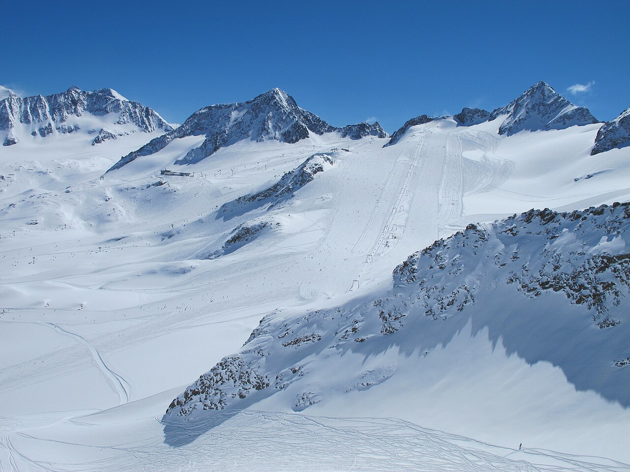
Stubaier Gletscher is a downhill ski area in Tyrol, Austria. Mapped terrain includes beginner, easy, intermediate, advanced routes. Its mapped lift network extends from approximately 1692 to 3208 metres above sea level. Cross-country skiing is also mapped within the area.
Data: OpenSkiData / OpenSkiMap, OpenStreetMap contributors (ODbL), Skimap.org, Who's On First, Mapterhorn.
Provider panorama/video player. Capture time is shown by the camera.
Open camera page ↗
Provider panorama/video player. Capture time is shown by the camera.
Open camera page ↗ECMWF · Εκτέλεση μοντέλου: Αναμενόμενη επόμενη ενημέρωση:
Ημέρα Ώρα (UTC) Θερμ. (°C) Υγρασία (%) Άνεμος (km/h) Άνεμος (κόμβοι) Άνεμος (Bft) Διεύθυνση Υετός (mm) Νέο χιόνι (cm) Πίεση (hPa) Σημείο παγοποίησης (m) Συνθήκες | Τετάρτη, 04/11 06:00 -2.4 80 2 1 1B S — — 1024 < 2262 Overcast 99% cloud 09:00 0.6 77 5 3 1B S 0.07 0 1026 < 2262 Overcast 85% cloud 12:00 2.3 72 9 5 2B S 0.10 0 1025 < 2262 Overcast 81% cloud 15:00 1.8 72 6 3 2B S 0 0 1025 < 2262 Partly cloudy 26% cloud 18:00 -2.2 78 4 2 1B SW 0 0 1026 < 2262 Cloudy 61% cloud 21:00 -3.5 80 3 2 1B SW 0.04 0 1028 < 2262 Overcast 83% cloud Πέμπτη, 05/11 00:00 -4.8 79 4 2 1B SW 0 0 1027 < 2262 Overcast 80% cloud 03:00 -5.4 79 3 2 1B W 0 0 1027 < 2262 Cloudy 76% cloud 06:00 -5.8 78 3 2 1B W 0 0 1026 < 2262 Cloudy 75% cloud 09:00 2.3 63 5 3 1B S 0 0 1027 < 2262 Clear 9% cloud 12:00 5.2 57 5 3 1B S 0 0 1025 2909 Clear 4% cloud 15:00 2.9 65 2 1 1B SW 0 0 1025 < 2262 Clear 1% cloud 18:00 -1.5 68 2 1 1B W 0 0 1024 < 2262 Clear 0% cloud 21:00 -1.5 54 2 1 1B SW 0 0 1024 < 2262 Clear 0% cloud Παρασκευή, 06/11 00:00 -1.4 51 2 1 1B SW 0 0 1023 3065 Clear 0% cloud 03:00 -1.9 55 2 1 1B SW 0 0 1022 3042 Clear 0% cloud 06:00 -2.2 59 2 1 1B SW 0 0 1021 3062 Clear 0% cloud 09:00 4.5 56 3 2 1B S 0 0 1021 3099 Clear 0% cloud 12:00 6.3 55 4 2 1B S 0 0 1020 3047 Clear 1% cloud 15:00 4.2 63 3 1 1B S 0 0 1019 2673 Clear 15% cloud 18:00 0.3 69 1 1 1B SW 0 0 1020 < 2262 Cloudy 79% cloud 21:00 0.5 69 3 2 1B S 0 0 1021 < 2262 Overcast 99% cloud Σάββατο, 07/11 00:00 -0.7 77 3 2 1B SW 0.00 0 1022 < 2262 Overcast 91% cloud 03:00 -1.1 78 2 1 1B SW 0.07 0 1021 < 2262 Cloudy 79% cloud 06:00 -1.6 78 2 1 1B SW 0.23 0 1022 < 2262 Overcast 89% cloud 09:00 1.7 75 6 3 2B S 0.54 0 1024 < 2262 Overcast 90% cloud 12:00 2.6 72 6 3 2B SE 0.38 0 1022 < 2262 Overcast 100% cloud 15:00 1.6 76 4 2 1B S 0.20 0 1023 < 2262 Overcast 87% cloud 18:00 -1 80 2 1 1B SW 0 0 1024 < 2262 Overcast 91% cloud 21:00 -2.9 80 2 1 1B SW 0 0 1025 < 2262 Overcast 87% cloud Κυριακή, 08/11 00:00 -4.1 78 3 2 1B W 0.00 0 1025 < 2262 Overcast 96% cloud 03:00 -3.6 77 3 2 1B SW 0.07 0.1 1025 < 2262 Overcast 99% cloud 06:00 -4.9 77 2 1 1B W 0.19 0.2 1025 < 2262 Overcast 89% cloud 09:00 0.1 70 4 2 1B SW 0.08 0 1026 < 2262 Cloudy 76% cloud 12:00 2.3 64 4 2 1B S 0 0 1024 < 2262 Overcast 84% cloud 15:00 0.6 68 3 1 1B S 0 0 1024 < 2262 Cloudy 65% cloud 18:00 -3.5 74 2 1 1B SW 0 0 1024 < 2262 Cloudy 64% cloud 21:00 -5.5 60 2 1 1B W 0 0 1024 < 2262 Partly cloudy 37% cloud Δευτέρα, 09/11 00:00 -5.3 51 3 1 1B SW 0 0 1024 < 2262 Cloudy 63% cloud 03:00 -1.7 59 3 1 1B SW 0.12 0 1023 < 2262 Cloudy 79% cloud 06:00 -2.9 67 4 2 1B SW 0 0 1022 < 2262 Overcast 91% cloud 09:00 2 66 6 3 2B S 0.08 0 1022 < 2262 Overcast 83% cloud 12:00 3.8 65 6 3 2B S 0 0 1021 2497 Partly cloudy 48% cloud 15:00 2.3 74 5 3 1B S 0 0 1020 < 2262 Overcast 97% cloud 18:00 0.2 76 5 3 1B S 0 0 1020 < 2262 Overcast 97% cloud 21:00 0.2 75 5 3 1B SW 0 0 1020 < 2262 Overcast 95% cloud Τρίτη, 10/11 00:00 1.1 78 6 3 1B SW 0.24 0 1018 < 2262 Overcast 99% cloud 03:00 1.6 77 5 3 1B SW 0 0 1017 < 2262 Overcast 99% cloud 06:00 -0.4 79 4 2 1B SW 0 0 1016 3012 Overcast 99% cloud |
|---|
Forecast table times: UTC.
Coordinates: 47.0132693°N, 11.1621766°E · Requested elevation: 1692 m. Model terrain: 2260 m. Terrain and 1000/925/850/700 hPa profiles are used for height estimates.
Outside the available profile, temperature uses an estimated 5.5°C/km height correction; wind retains the nearest available model-level value. Humidity is estimated with adjusted pressure and temperature.
These are altitude estimates, not a simulation of local mountain terrain. Precipitation, cloud and sea-level pressure use horizontal interpolation only.
Precipitation includes rain and snow water equivalent: preceding 3 hours through day 6, then 6 hours (see cell tooltip). Snow (cm) estimates fresh snowfall from precipitation and temperature using the GFS conversion; it is not snow depth on the ground. Freezing (m) uses additional 600/500 hPa temperatures when available and estimates the lowest resolved 0°C crossing above sea level. When all sampled levels are warm, the upper profile limit is shown (see tooltip). < marks an entirely cold sampled profile and its lower height limit. No extrapolation is used.
Source: ECMWF · CC BY 4.0 · Processed by Snow Report.
ECMWF · Εκτέλεση μοντέλου: Αναμενόμενη επόμενη ενημέρωση:
Ημέρα Ώρα (UTC) Θερμ. (°C) Υγρασία (%) Άνεμος (km/h) Άνεμος (κόμβοι) Άνεμος (Bft) Διεύθυνση Υετός (mm) Νέο χιόνι (cm) Πίεση (hPa) Σημείο παγοποίησης (m) Συνθήκες | Τετάρτη, 04/11 06:00 -7.4 84 16 9 3B S — — 1024 < 2334 Overcast 97% cloud 09:00 -7.7 81 20 11 3B S 0.05 0.1 1026 < 2334 Overcast 81% cloud 12:00 -7 74 24 13 4B S 0.08 0.1 1025 < 2334 Cloudy 73% cloud 15:00 -5.9 61 20 11 4B S 0 0 1025 < 2334 Partly cloudy 31% cloud 18:00 -4.9 49 20 11 3B S 0 0 1026 < 2334 Cloudy 64% cloud 21:00 -4.1 48 20 11 4B S 0.07 0.1 1028 < 2334 Cloudy 76% cloud Πέμπτη, 05/11 00:00 -3.4 43 17 9 3B S 0 0 1027 < 2334 Cloudy 73% cloud 03:00 -2.7 42 16 9 3B S 0 0 1026 < 2334 Cloudy 67% cloud 06:00 -2.3 43 14 8 3B S 0 0 1026 < 2334 Cloudy 64% cloud 09:00 -1.5 35 11 6 2B S 0 0 1026 < 2334 Clear 7% cloud 12:00 -1.3 31 8 4 2B SW 0 0 1025 2893 Clear 3% cloud 15:00 -0.9 24 3 1 1B W 0 0 1024 < 2334 Clear 1% cloud 18:00 -0.9 28 3 2 1B SE 0 0 1024 < 2334 Clear 0% cloud 21:00 -0.5 34 11 6 2B S 0 0 1024 < 2334 Clear 0% cloud Παρασκευή, 06/11 00:00 -0.3 37 13 7 3B S 0 0 1023 3077 Clear 0% cloud 03:00 -0.2 34 11 6 2B S 0 0 1021 3054 Clear 0% cloud 06:00 -0.4 38 11 6 2B S 0 0 1021 3071 Clear 0% cloud 09:00 -0.4 39 15 8 3B S 0 0 1021 3099 Clear 2% cloud 12:00 -1 44 18 10 3B S 0 0 1019 3021 Clear 2% cloud 15:00 -1.9 76 17 9 3B S 0 0 1019 2639 Clear 17% cloud 18:00 -2.7 60 21 11 4B S 0.01 0 1020 < 2334 Overcast 83% cloud 21:00 -3.5 63 28 15 4B SE 0 0 1021 < 2334 Overcast 99% cloud Σάββατο, 07/11 00:00 -5.2 64 33 18 5B S 0 0 1022 < 2334 Overcast 94% cloud 03:00 -5.7 75 29 16 5B S 0.07 0.1 1021 < 2334 Cloudy 72% cloud 06:00 -6.7 84 25 14 4B SE 0.31 0.3 1022 < 2334 Overcast 92% cloud 09:00 -7.1 90 29 16 5B S 0.56 0.6 1023 < 2334 Overcast 90% cloud 12:00 -7.4 93 20 11 3B S 0.36 0.4 1022 < 2334 Overcast 100% cloud 15:00 -7.6 93 16 8 3B S 0.19 0.2 1023 < 2334 Overcast 81% cloud 18:00 -7.3 71 19 10 3B S 0.00 0 1024 < 2334 Overcast 90% cloud 21:00 -7.5 74 16 9 3B S 0 0 1025 < 2334 Overcast 84% cloud Κυριακή, 08/11 00:00 -8 79 11 6 2B SW 0 0 1025 < 2334 Overcast 95% cloud 03:00 -8.3 87 10 6 2B SW 0.10 0.1 1024 < 2334 Overcast 99% cloud 06:00 -8.6 91 11 6 2B SW 0.14 0.1 1025 < 2334 Overcast 85% cloud 09:00 -8.7 84 12 6 2B W 0.06 0.1 1025 < 2334 Cloudy 68% cloud 12:00 -8.4 79 11 6 2B W 0.01 0 1024 < 2334 Overcast 81% cloud 15:00 -8.1 70 13 7 3B W 0.02 0 1023 < 2334 Partly cloudy 49% cloud 18:00 -7.3 45 16 8 3B W 0.02 0 1024 < 2334 Cloudy 51% cloud 21:00 -6.1 30 21 11 4B W 0.02 0 1024 < 2334 Partly cloudy 31% cloud Δευτέρα, 09/11 00:00 -5.1 35 20 11 4B W 0.01 0 1023 < 2334 Cloudy 72% cloud 03:00 -4.5 63 20 11 4B W 0.11 0.1 1022 < 2334 Cloudy 75% cloud 06:00 -3.4 68 21 11 4B W 0 0 1021 < 2334 Overcast 92% cloud 09:00 -3 67 21 11 4B W 0.05 0.1 1021 < 2334 Overcast 84% cloud 12:00 -2.5 58 18 10 3B W 0 0 1020 2572 Partly cloudy 49% cloud 15:00 -2.7 61 21 12 4B W 0.00 0 1020 < 2334 Overcast 95% cloud 18:00 -2 68 20 11 3B SW 0 0 1019 < 2334 Overcast 94% cloud 21:00 -1.7 76 23 12 4B SW 0 0 1019 < 2334 Overcast 93% cloud Τρίτη, 10/11 00:00 -1.5 83 27 15 4B W 0.23 0 1018 < 2334 Overcast 97% cloud 03:00 -1.3 84 25 13 4B W 0 0 1016 < 2334 Overcast 98% cloud 06:00 -0.8 77 19 10 3B W 0 0 1015 3030 Overcast 98% cloud |
|---|
Forecast table times: UTC.
Coordinates: 46.9805919°N, 11.1043457°E · Requested elevation: 3208 m. Model terrain: 2332 m. Terrain and 1000/925/850/700 hPa profiles are used for height estimates.
Outside the available profile, temperature uses an estimated 5.5°C/km height correction; wind retains the nearest available model-level value. Humidity is estimated with adjusted pressure and temperature.
These are altitude estimates, not a simulation of local mountain terrain. Precipitation, cloud and sea-level pressure use horizontal interpolation only.
Precipitation includes rain and snow water equivalent: preceding 3 hours through day 6, then 6 hours (see cell tooltip). Snow (cm) estimates fresh snowfall from precipitation and temperature using the GFS conversion; it is not snow depth on the ground. Freezing (m) uses additional 600/500 hPa temperatures when available and estimates the lowest resolved 0°C crossing above sea level. When all sampled levels are warm, the upper profile limit is shown (see tooltip). < marks an entirely cold sampled profile and its lower height limit. No extrapolation is used.