Wettervorhersagen für Skigebiete weltweit

Farbskala Temperatur · Wind · Regen · Schnee
Jede Farbe beginnt beim angegebenen Wert. Die Windfarben stimmen in allen drei Einheiten überein. Trockene Zellen bleiben neutral. Die Farben beschreiben die Werte und sind keine amtlichen Wetterwarnungen.
Spirit Mountain - Low lift station
ECMWF · Modelllauf: Nächste Aktualisierung erwartet:
Tag Uhrzeit (UTC) Temp. (°C) Luftfeuchtigkeit (%) Wind (km/h) Wind (Knoten) Wind (Bft) Richtung Niederschlag (mm) Neuschnee (cm) Luftdruck (hPa) Nullgradgrenze (m) Wetterlage | Mittwoch, 04/11 06:00 11.7 96 22 12 4B NE — — 1003 2980 Overcast 100% cloud  09:00 10.9 97 24 13 4B NE 2.6 0 1001 2967 Overcast 100% cloud 12:00 11.1 97 24 13 4B NE 2.2 0 1000 2953 Overcast 100% cloud 15:00 10.4 97 17 9 3B NE 9.2 0 999 2939 Overcast 100% cloud 18:00 12.1 93 14 7 3B NE 0.19 0 998 2858 Overcast 100% cloud 21:00 12.8 92 10 5 2B NE 0.50 0 998 2902 Overcast 100% cloud Donnerstag, 05/11 00:00 10.9 88 17 9 3B N 0.65 0 999 2819 Overcast 100% cloud 03:00 9.3 93 21 11 4B N 3.0 0 1001 2716 Overcast 100% cloud 06:00 8.8 93 20 11 4B N 4.1 0 1002 2463 Overcast 100% cloud 09:00 7.2 90 25 13 4B N 1.5 0 1005 2375 Overcast 100% cloud 12:00 7.3 72 17 9 3B N 0.37 0 1009 2265 Overcast 88% cloud 15:00 6.8 70 20 11 4B N 0.02 0 1013 2019 Overcast 81% cloud 18:00 7.1 62 19 10 3B N 0 0 1015 1004 Overcast 93% cloud 21:00 6.3 58 16 9 3B N 0 0 1018 869 Overcast 98% cloud Freitag, 06/11 00:00 4.8 60 16 8 3B N 0 0 1021 746 Overcast 94% cloud 03:00 4.3 58 12 7 3B NE 0 0 1022 710 Cloudy 54% cloud  06:00 2.5 71 7 4 2B N 0 0 1023 613 Partly cloudy 23% cloud  09:00 1.2 81 10 5 2B N 0 0 1025 462 Clear 1% cloud  12:00 0.3 84 7 4 2B N 0 0 1026 < 316 Clear 5% cloud 15:00 3.2 71 4 2 1B NE 0 0 1027 602 Clear 4% cloud 18:00 6 58 2 1 1B SE 0 0 1026 781 Clear 4% cloud 21:00 6.9 56 3 2 1B SE 0 0 1024 2656 Clear 0% cloud Samstag, 07/11 00:00 3.5 76 3 2 1B SE 0 0 1024 2918 Clear 2% cloud 03:00 2.4 85 4 2 1B S 0 0 1024 2905 Overcast 85% cloud 06:00 1.4 83 9 5 2B SW 0 0 1023 2954 Overcast 99% cloud 09:00 1.8 81 9 5 2B SW 0 0 1023 2731 Cloudy 58% cloud 12:00 0.8 86 10 6 2B SW 0 0 1022 2504 Clear 0% cloud 15:00 3.7 78 11 6 2B SW 0 0 1022 2779 Clear 0% cloud 18:00 9.5 59 14 7 3B SW 0 0 1019 2978 Cloudy 66% cloud 21:00 10.9 55 15 8 3B SW 0 0 1017 3035 Overcast 96% cloud Sonntag, 08/11 00:00 7.4 72 16 9 3B SW 0 0 1016 3053 Partly cloudy 41% cloud 03:00 7.5 77 19 10 3B SW 0 0 1014 3044 Overcast 95% cloud 06:00 8.6 75 18 10 3B W 0 0 1013 3035 Overcast 94% cloud 09:00 7.4 76 15 8 3B W 0 0 1015 3029 Clear 5% cloud 12:00 6.6 73 16 9 3B W 0 0 1016 3026 Clear 0% cloud 15:00 8.2 65 14 8 3B W 0 0 1019 3039 Clear 0% cloud 18:00 11.5 52 16 9 3B NW 0 0 1019 3053 Partly cloudy 44% cloud 21:00 12 50 13 7 3B NW 0 0 1019 3062 Cloudy 61% cloud Montag, 09/11 00:00 6.9 72 10 5 2B NW 0 0 1020 2969 Clear 0% cloud 03:00 5.4 78 8 4 2B NW 0 0 1020 3079 Overcast 80% cloud 06:00 3.8 84 3 2 1B W 0 0 1021 3084 Overcast 92% cloud 09:00 2.9 87 6 4 2B SW 0 0 1019 3083 Overcast 88% cloud 12:00 3.4 88 11 6 2B SW 0 0 1019 3077 Overcast 98% cloud 15:00 6.8 77 12 7 3B SW 0 0 1018 3074 Overcast 83% cloud 18:00 12.4 57 17 9 3B SW 0 0 1014 3063 Cloudy 70% cloud 21:00 14.3 56 15 8 3B SW 0 0 1012 3047 Cloudy 74% cloud Dienstag, 10/11 00:00 10.3 76 14 7 3B W 0 0 1012 3039 Overcast 97% cloud 03:00 9.4 76 17 9 3B W 0 0 1012 2789 Overcast 93% cloud 06:00 8.5 69 20 11 4B NW 0 0 1013 2420 Clear 0% cloud |
|---|
Forecast notes
Forecast table times: UTC.
Coordinates: 46.71578°N, -92.2064751°E · Requested elevation: 220 m. Model terrain: 314 m. Terrain and 1000/925/850/700 hPa profiles are used for height estimates.
Outside the available profile, temperature uses an estimated 5.5°C/km height correction; wind retains the nearest available model-level value. Humidity is estimated with adjusted pressure and temperature.
These are altitude estimates, not a simulation of local mountain terrain. Precipitation, cloud and sea-level pressure use horizontal interpolation only.
Precipitation includes rain and snow water equivalent: preceding 3 hours through day 6, then 6 hours (see cell tooltip). Snow (cm) estimates fresh snowfall from precipitation and temperature using the GFS conversion; it is not snow depth on the ground. Freezing (m) uses additional 600/500 hPa temperatures when available and estimates the lowest resolved 0°C crossing above sea level. When all sampled levels are warm, the upper profile limit is shown (see tooltip). < marks an entirely cold sampled profile and its lower height limit. No extrapolation is used.
Source: ECMWF · CC BY 4.0 · Processed by Snow Report.
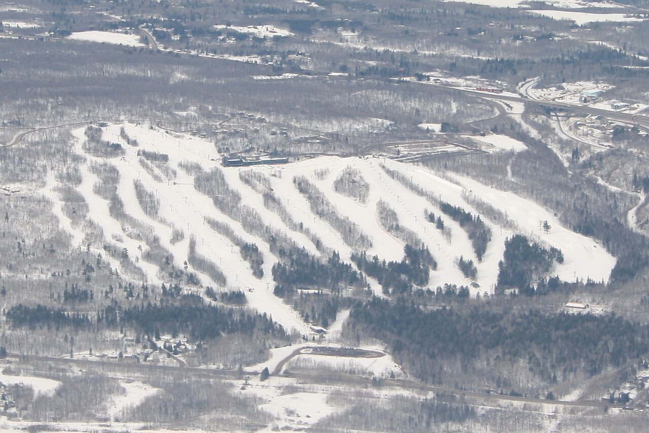
Spirit Mountain is a downhill ski area in Minnesota, United States. Mapped terrain includes beginner, easy, intermediate, advanced routes. Its mapped lift network extends from approximately 220 to 392 metres above sea level. Cross-country skiing is also mapped within the area.
Data: OpenSkiData / OpenSkiMap, OpenStreetMap contributors (ODbL), Skimap.org, Who's On First, Mapterhorn.
Spirit Mountain - Base lift station
ECMWF · Modelllauf: Nächste Aktualisierung erwartet:
Tag Uhrzeit (UTC) Temp. (°C) Luftfeuchtigkeit (%) Wind (km/h) Wind (Knoten) Wind (Bft) Richtung Niederschlag (mm) Neuschnee (cm) Luftdruck (hPa) Nullgradgrenze (m) Wetterlage | Mittwoch, 04/11 06:00 11.6 97 22 12 4B NE — — 1003 2980 Overcast 100% cloud 09:00 10.9 97 24 13 4B NE 2.6 0 1002 2967 Overcast 100% cloud 12:00 11.1 97 24 13 4B NE 2.2 0 1000 2953 Overcast 100% cloud 15:00 10.3 97 17 9 3B NE 9.3 0 999 2939 Overcast 100% cloud 18:00 12.1 93 14 7 3B NE 0.19 0 998 2857 Overcast 100% cloud 21:00 12.8 93 10 5 2B NE 0.48 0 998 2903 Overcast 100% cloud Donnerstag, 05/11 00:00 10.9 88 17 9 3B N 0.62 0 999 2820 Overcast 100% cloud 03:00 9.2 94 21 11 4B N 3.0 0 1001 2717 Overcast 100% cloud 06:00 8.7 94 20 11 4B N 4.1 0 1002 2464 Overcast 100% cloud 09:00 7.1 91 25 13 4B N 1.5 0 1005 2376 Overcast 100% cloud 12:00 7.3 72 17 9 3B N 0.37 0 1009 2266 Overcast 87% cloud 15:00 6.7 70 20 11 4B N 0.02 0 1013 2024 Overcast 81% cloud 18:00 7.1 62 19 10 3B N 0 0 1015 1004 Overcast 93% cloud 21:00 6.2 58 16 9 3B N 0 0 1018 869 Overcast 98% cloud Freitag, 06/11 00:00 4.7 61 16 8 3B N 0 0 1021 746 Overcast 94% cloud 03:00 4.2 58 12 7 2B NE 0 0 1022 711 Cloudy 53% cloud 06:00 2.4 71 7 4 2B N 0 0 1023 611 Partly cloudy 22% cloud 09:00 1.1 81 10 5 2B N 0 0 1025 459 Clear 1% cloud 12:00 0.2 84 7 4 2B N 0 0 1026 < 317 Clear 5% cloud 15:00 3.1 71 4 2 1B NE 0 0 1027 602 Clear 4% cloud 18:00 5.9 58 3 1 1B SE 0 0 1026 781 Clear 4% cloud 21:00 6.8 56 4 2 1B SE 0 0 1024 2658 Clear 0% cloud Samstag, 07/11 00:00 3.4 76 3 2 1B SE 0 0 1024 2918 Clear 2% cloud 03:00 2.4 85 4 2 1B S 0 0 1024 2905 Overcast 85% cloud 06:00 1.3 83 9 5 2B SW 0 0 1023 2954 Overcast 99% cloud 09:00 1.7 81 9 5 2B SW 0 0 1023 2730 Cloudy 58% cloud 12:00 0.7 87 10 5 2B SW 0 0 1022 2504 Clear 0% cloud 15:00 3.6 78 11 6 2B SW 0 0 1022 2779 Clear 0% cloud 18:00 9.4 59 14 7 3B SW 0 0 1019 2978 Cloudy 65% cloud 21:00 10.8 55 15 8 3B SW 0 0 1017 3036 Overcast 96% cloud Sonntag, 08/11 00:00 7.3 72 16 9 3B SW 0 0 1016 3053 Partly cloudy 41% cloud 03:00 7.5 77 19 10 3B SW 0 0 1014 3044 Overcast 95% cloud 06:00 8.6 75 18 10 3B W 0 0 1013 3035 Overcast 94% cloud 09:00 7.4 76 15 8 3B W 0 0 1015 3029 Clear 5% cloud 12:00 6.6 73 16 9 3B W 0 0 1016 3026 Clear 0% cloud 15:00 8.2 66 14 8 3B W 0 0 1019 3039 Clear 0% cloud 18:00 11.4 52 16 9 3B NW 0 0 1019 3053 Partly cloudy 44% cloud 21:00 11.9 50 13 7 3B NW 0 0 1019 3062 Cloudy 60% cloud Montag, 09/11 00:00 6.8 73 10 5 2B NW 0 0 1020 2969 Clear 0% cloud 03:00 5.3 79 8 4 2B NW 0 0 1020 3079 Overcast 81% cloud 06:00 3.7 84 3 2 1B W 0 0 1021 3084 Overcast 92% cloud 09:00 2.9 87 6 3 2B SW 0 0 1019 3083 Overcast 88% cloud 12:00 3.3 88 11 6 2B SW 0 0 1019 3077 Overcast 98% cloud 15:00 6.7 78 12 7 3B SW 0 0 1018 3074 Overcast 83% cloud 18:00 12.3 57 17 9 3B SW 0 0 1014 3063 Cloudy 70% cloud 21:00 14.2 56 15 8 3B SW 0 0 1012 3047 Cloudy 74% cloud Dienstag, 10/11 00:00 10.2 76 14 7 3B W 0 0 1012 3039 Overcast 97% cloud 03:00 9.3 77 17 9 3B W 0 0 1012 2788 Overcast 93% cloud 06:00 8.4 69 20 11 4B NW 0 0 1013 2419 Clear 0% cloud |
|---|
Forecast notes
Forecast table times: UTC.
Coordinates: 46.7181473°N, -92.2086621°E · Requested elevation: 234 m. Model terrain: 315 m. Terrain and 1000/925/850/700 hPa profiles are used for height estimates.
Outside the available profile, temperature uses an estimated 5.5°C/km height correction; wind retains the nearest available model-level value. Humidity is estimated with adjusted pressure and temperature.
These are altitude estimates, not a simulation of local mountain terrain. Precipitation, cloud and sea-level pressure use horizontal interpolation only.
Precipitation includes rain and snow water equivalent: preceding 3 hours through day 6, then 6 hours (see cell tooltip). Snow (cm) estimates fresh snowfall from precipitation and temperature using the GFS conversion; it is not snow depth on the ground. Freezing (m) uses additional 600/500 hPa temperatures when available and estimates the lowest resolved 0°C crossing above sea level. When all sampled levels are warm, the upper profile limit is shown (see tooltip). < marks an entirely cold sampled profile and its lower height limit. No extrapolation is used.
Source: ECMWF · CC BY 4.0 · Processed by Snow Report.
Spirit Mountain - Top lift station
ECMWF · Modelllauf: Nächste Aktualisierung erwartet:
Tag Uhrzeit (UTC) Temp. (°C) Luftfeuchtigkeit (%) Wind (km/h) Wind (Knoten) Wind (Bft) Richtung Niederschlag (mm) Neuschnee (cm) Luftdruck (hPa) Nullgradgrenze (m) Wetterlage | Mittwoch, 04/11 06:00 11.1 99 29 16 5B NE — — 1003 2980 Overcast 100% cloud 09:00 10.6 100 28 15 4B NE 2.5 0 1001 2967 Overcast 100% cloud 12:00 10.8 100 30 16 5B NE 2.2 0 1000 2953 Overcast 100% cloud 15:00 10.1 99 19 10 3B E 9.2 0 999 2939 Overcast 100% cloud 18:00 11.7 96 15 8 3B NE 0.19 0 998 2858 Overcast 100% cloud 21:00 12 96 13 7 3B NE 0.48 0 998 2904 Overcast 100% cloud Donnerstag, 05/11 00:00 9.9 91 22 12 4B N 0.61 0 999 2822 Overcast 100% cloud 03:00 8.3 95 27 15 4B N 3.0 0 1001 2720 Overcast 100% cloud 06:00 7.7 96 27 14 4B N 4.1 0 1002 2465 Overcast 100% cloud 09:00 6.1 92 32 17 5B N 1.6 0 1005 2378 Overcast 100% cloud 12:00 6.1 75 23 12 4B N 0.35 0 1009 2270 Overcast 87% cloud 15:00 5.5 75 23 13 4B N 0.02 0 1013 2033 Overcast 82% cloud 18:00 5.7 66 21 11 4B N 0 0 1015 1006 Overcast 93% cloud 21:00 5 62 18 9 3B N 0 0 1018 869 Overcast 98% cloud Freitag, 06/11 00:00 3.5 64 17 9 3B N 0 0 1021 746 Overcast 94% cloud 03:00 3 61 14 7 3B NE 0 0 1022 711 Cloudy 52% cloud 06:00 1.3 74 8 4 2B N 0 0 1023 604 Partly cloudy 21% cloud 09:00 0.2 82 9 5 2B N 0 0 1025 436 Clear 1% cloud 12:00 -0.6 85 6 3 2B N 0 0 1026 < 323 Clear 3% cloud 15:00 2 74 3 2 1B NE 0 0 1027 603 Clear 4% cloud 18:00 4.6 61 3 1 1B S 0 0 1026 785 Clear 4% cloud 21:00 5.7 58 3 2 1B S 0 0 1024 2666 Clear 0% cloud Samstag, 07/11 00:00 2.7 76 3 1 1B S 0 0 1024 2920 Clear 2% cloud 03:00 1.8 83 5 3 1B SW 0 0 1024 2905 Overcast 85% cloud 06:00 0.9 81 11 6 2B SW 0 0 1023 2953 Overcast 99% cloud 09:00 1.3 80 12 6 2B SW 0 0 1023 2730 Cloudy 59% cloud 12:00 0.6 85 12 7 3B SW 0 0 1022 2505 Clear 0% cloud 15:00 3.2 78 14 8 3B SW 0 0 1022 2782 Clear 0% cloud 18:00 8.3 60 17 9 3B SW 0 0 1019 2978 Cloudy 66% cloud 21:00 9.7 57 18 10 3B SW 0 0 1017 3040 Overcast 96% cloud Sonntag, 08/11 00:00 6.9 71 21 11 4B SW 0 0 1016 3053 Partly cloudy 41% cloud 03:00 7.2 75 27 14 4B SW 0 0 1014 3044 Overcast 95% cloud 06:00 8 76 25 13 4B W 0 0 1013 3035 Overcast 94% cloud 09:00 6.9 74 21 11 4B NW 0 0 1015 3029 Clear 5% cloud 12:00 6 73 22 12 4B NW 0 0 1016 3026 Clear 0% cloud 15:00 7.1 68 19 10 3B NW 0 0 1019 3039 Clear 0% cloud 18:00 10.1 55 18 10 3B NW 0 0 1019 3054 Partly cloudy 43% cloud 21:00 10.8 52 15 8 3B NW 0 0 1019 3062 Cloudy 59% cloud Montag, 09/11 00:00 6.3 71 13 7 3B NW 0 0 1020 2969 Clear 0% cloud 03:00 5 73 10 6 2B NW 0 0 1020 3079 Overcast 82% cloud 06:00 3.7 77 5 3 1B W 0 0 1021 3084 Overcast 93% cloud 09:00 3 81 9 5 2B SW 0 0 1019 3083 Overcast 87% cloud 12:00 3.4 84 17 9 3B SW 0 0 1019 3077 Overcast 98% cloud 15:00 6.6 73 20 11 4B SW 0 0 1018 3074 Overcast 83% cloud 18:00 11.4 59 23 12 4B SW 0 0 1014 3063 Cloudy 70% cloud 21:00 13.2 58 18 10 3B SW 0 0 1012 3047 Cloudy 74% cloud Dienstag, 10/11 00:00 9.8 74 18 10 3B W 0 0 1012 3039 Overcast 97% cloud 03:00 9 73 24 13 4B W 0 0 1012 2787 Overcast 93% cloud 06:00 7.7 69 26 14 4B NW 0 0 1013 2419 Clear 0% cloud |
|---|
Forecast notes
Forecast table times: UTC.
Coordinates: 46.7170979°N, -92.2201616°E · Requested elevation: 392 m. Model terrain: 321 m. Terrain and 1000/925/850/700 hPa profiles are used for height estimates.
These are altitude estimates, not a simulation of local mountain terrain. Precipitation, cloud and sea-level pressure use horizontal interpolation only.
Precipitation includes rain and snow water equivalent: preceding 3 hours through day 6, then 6 hours (see cell tooltip). Snow (cm) estimates fresh snowfall from precipitation and temperature using the GFS conversion; it is not snow depth on the ground. Freezing (m) uses additional 600/500 hPa temperatures when available and estimates the lowest resolved 0°C crossing above sea level. When all sampled levels are warm, the upper profile limit is shown (see tooltip). < marks an entirely cold sampled profile and its lower height limit. No extrapolation is used.