Worldwide Ski Resort Forecasts

Colour guide Temperature · Wind · Rain · Snow
Each colour starts at the value shown. Wind colours match across all three units. Dry cells stay neutral. Colours describe the displayed values, not official weather warnings.
Sapporo Teine - Low lift station
ECMWF · Model run: Next update expected:
Day Time (UTC) Temp. (°C) Humidity (%) Wind (km/h) Wind (knots) Wind (Bft) Direction Precip. (mm) Snow (cm) Pressure (hPa) Freezing (m) Conditions | Wednesday, 04/11 06:00 6.2 56 2 1 1B W — — 1027 1246 Clear 0% cloud  09:00 3 75 8 4 2B S 0 0 1027 1587 Clear 0% cloud 12:00 2.2 72 8 4 2B S 0 0 1027 1749 Partly cloudy 33% cloud  15:00 1.9 69 8 4 2B S 0 0 1025 1749 Clear 2% cloud 18:00 2.5 69 9 5 2B S 0 0 1024 1875 Partly cloudy 37% cloud 21:00 3 72 9 5 2B S 0 0 1022 1936 Partly cloudy 48% cloud Thursday, 05/11 00:00 8.8 57 12 6 2B S 0 0 1021 1993 Overcast 94% cloud  03:00 11.5 65 13 7 3B SE 0 0 1018 2106 Partly cloudy 38% cloud 06:00 11.7 70 10 6 2B SE 0 0 1014 2149 Overcast 100% cloud 09:00 8.9 91 12 6 2B SE 0.26 0 1013 2135 Overcast 100% cloud 12:00 8.7 94 8 5 2B SE 5.5 0 1010 2166 Overcast 100% cloud 15:00 8.7 92 4 2 1B E 7.0 0 1005 2303 Overcast 100% cloud 18:00 8.5 88 10 5 2B NW 5.2 0 1002 2163 Overcast 100% cloud 21:00 8.4 86 11 6 2B NW 0.80 0 1001 1911 Overcast 93% cloud Friday, 06/11 00:00 10.2 71 15 8 3B W 0 0 1000 1814 Partly cloudy 23% cloud 03:00 12.1 56 15 8 3B W 0 0 998 1730 Partly cloudy 25% cloud 06:00 11.3 61 8 4 2B SW 0.01 0 997 1735 Cloudy 75% cloud  09:00 7.2 81 27 15 4B W 0.44 0 1000 1218 Cloudy 77% cloud 12:00 4 81 24 13 4B W 0.54 0 1002 805 Cloudy 74% cloud 15:00 1.6 75 33 18 5B W 0.66 0 1003 516 Cloudy 68% cloud 18:00 -0.3 71 32 17 5B W 0.76 0.2 1004 310 Cloudy 76% cloud 21:00 -1 73 33 18 5B W 0.92 0.3 1003 < 276 Cloudy 72% cloud Saturday, 07/11 00:00 -0.2 71 34 19 5B W 1.1 0.3 1004 318 Cloudy 69% cloud 03:00 0.2 70 39 21 6B W 1.3 0.4 1003 367 Overcast 88% cloud 06:00 -0.2 78 38 20 5B W 1.6 0.5 1005 323 Overcast 88% cloud 09:00 0.1 79 44 24 6B W 1.3 0.4 1007 348 Overcast 86% cloud 12:00 -0 79 43 23 6B W 0.83 0.2 1010 337 Overcast 92% cloud 15:00 -0 82 39 21 6B W 0.50 0.1 1013 340 Overcast 97% cloud 18:00 0 82 37 20 5B W 0.47 0.1 1016 347 Overcast 96% cloud 21:00 0.1 80 33 18 5B W 0.36 0.1 1019 351 Overcast 91% cloud Sunday, 08/11 00:00 0.6 78 31 17 5B W 0.27 0.1 1022 391 Overcast 86% cloud 03:00 1.1 72 28 15 4B W 0.18 0 1023 438 Overcast 86% cloud 06:00 0.8 73 25 13 4B W 0.25 0.1 1025 412 Overcast 91% cloud 09:00 -0.4 77 23 12 4B W 0.07 0 1027 303 Overcast 89% cloud 12:00 -0.8 78 20 11 4B W 0.13 0 1027 < 276 Overcast 92% cloud 15:00 -1 75 23 12 4B W 0.09 0 1027 < 276 Overcast 85% cloud 18:00 -1.6 77 23 13 4B W 0.16 0 1027 < 276 Overcast 83% cloud 21:00 -2.3 78 20 11 4B W 0.31 0.1 1027 < 276 Overcast 82% cloud Monday, 09/11 00:00 -1.7 71 20 11 4B W 0.47 0.1 1027 < 276 Cloudy 76% cloud 03:00 -1.3 62 22 12 4B W 0.95 0.3 1025 < 276 Cloudy 74% cloud 06:00 -2.3 65 15 8 3B W 0.85 0.3 1024 < 276 Cloudy 74% cloud 09:00 -4.2 76 13 7 3B W 1.3 1.3 1024 < 276 Overcast 91% cloud 12:00 -3.8 74 12 7 2B NW 1.5 1.5 1023 < 276 Overcast 92% cloud 15:00 -5 79 7 4 2B NW 0.62 0.6 1022 < 276 Overcast 90% cloud 18:00 -5.3 83 7 4 2B NW 2.7 2.1 1022 < 276 Overcast 88% cloud 21:00 -5 78 14 8 3B NW 2.3 1.8 1024 < 276 Overcast 94% cloud Tuesday, 10/11 00:00 -2.2 61 17 9 3B NW 0.98 0.3 1026 < 276 Partly cloudy 36% cloud 03:00 -0.1 60 23 12 4B NW 0.24 0 1025 333 Cloudy 50% cloud 06:00 -0.3 73 19 10 3B NW 0.32 0.1 1026 315 Overcast 87% cloud |
|---|
Forecast notes
Forecast table times: UTC.
Coordinates: 43.1034701°N, 141.2073242°E · Requested elevation: 340 m. Model terrain: 274 m. Terrain and 1000/925/850/700 hPa profiles are used for height estimates.
These are altitude estimates, not a simulation of local mountain terrain. Precipitation, cloud and sea-level pressure use horizontal interpolation only.
Precipitation includes rain and snow water equivalent: preceding 3 hours through day 6, then 6 hours (see cell tooltip). Snow (cm) estimates fresh snowfall from precipitation and temperature using the GFS conversion; it is not snow depth on the ground. Freezing (m) uses additional 600/500 hPa temperatures when available and estimates the lowest resolved 0°C crossing above sea level. When all sampled levels are warm, the upper profile limit is shown (see tooltip). < marks an entirely cold sampled profile and its lower height limit. No extrapolation is used.
Source: ECMWF · CC BY 4.0 · Processed by Snow Report.
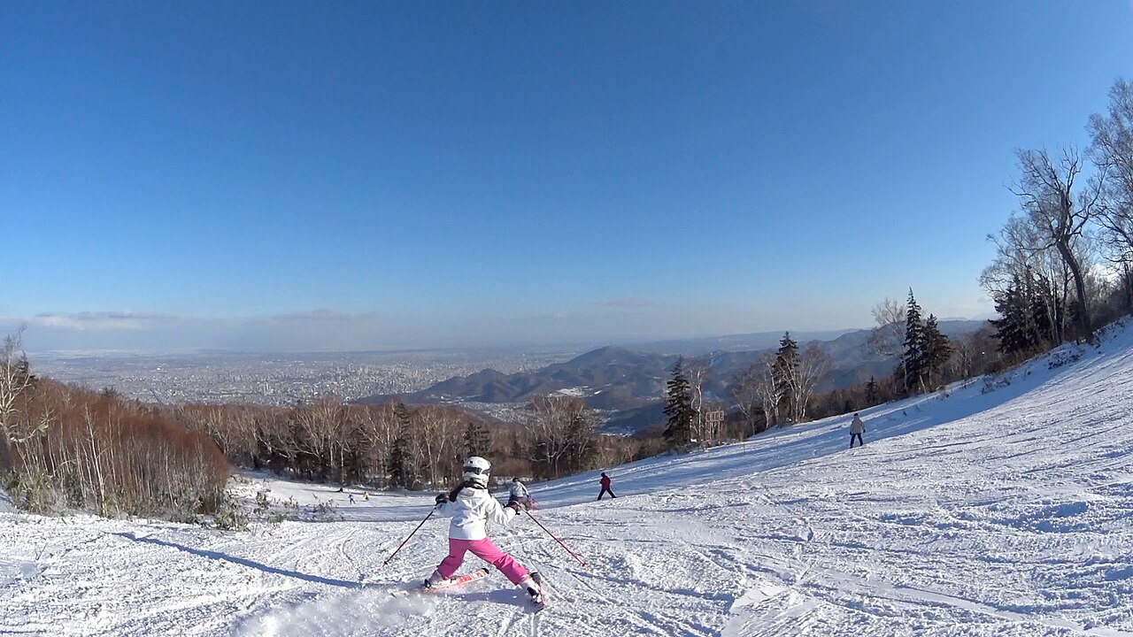
Sapporo Teine is a downhill ski area in Hokkaido Prefecture, Japan. Mapped terrain includes easy, intermediate, advanced routes. Its mapped lift network extends from approximately 340 to 986 metres above sea level.
Data: OpenSkiData / OpenSkiMap, OpenStreetMap contributors (ODbL), Skimap.org, Who's On First, Mapterhorn.
Sapporo Teine - Base lift station
ECMWF · Model run: Next update expected:
Day Time (UTC) Temp. (°C) Humidity (%) Wind (km/h) Wind (knots) Wind (Bft) Direction Precip. (mm) Snow (cm) Pressure (hPa) Freezing (m) Conditions | Wednesday, 04/11 06:00 5.5 56 4 2 1B SW — — 1027 1249 Clear 0% cloud 09:00 2.7 71 9 5 2B S 0 0 1027 1590 Clear 0% cloud 12:00 2.3 64 10 6 2B SW 0 0 1027 1753 Partly cloudy 32% cloud 15:00 2.2 61 9 5 2B SW 0 0 1025 1753 Clear 2% cloud 18:00 2.7 64 11 6 2B SW 0 0 1024 1878 Partly cloudy 37% cloud 21:00 3.3 66 10 5 2B S 0 0 1022 1938 Partly cloudy 48% cloud Thursday, 05/11 00:00 8.3 54 13 7 3B S 0 0 1021 1995 Overcast 94% cloud 03:00 10.8 65 13 7 3B S 0 0 1018 2109 Partly cloudy 37% cloud 06:00 11.1 70 11 6 2B SE 0 0 1014 2151 Overcast 100% cloud 09:00 8.4 90 12 6 2B SE 0.28 0 1013 2135 Overcast 100% cloud 12:00 8.3 95 10 5 2B SE 5.6 0 1010 2169 Overcast 100% cloud 15:00 8.2 93 6 3 1B E 7.1 0 1005 2306 Overcast 100% cloud 18:00 8 90 9 5 2B NW 5.2 0 1002 2169 Overcast 100% cloud 21:00 7.8 87 13 7 3B NW 0.80 0 1001 1913 Overcast 93% cloud Friday, 06/11 00:00 9.5 71 16 9 3B NW 0 0 1000 1818 Partly cloudy 23% cloud 03:00 11.4 57 16 9 3B W 0 0 998 1731 Partly cloudy 26% cloud 06:00 10.6 62 10 6 2B SW 0.01 0 997 1736 Cloudy 76% cloud 09:00 6.5 81 29 16 5B W 0.42 0 1000 1220 Cloudy 78% cloud 12:00 3.2 82 27 15 4B W 0.52 0 1002 805 Cloudy 76% cloud 15:00 0.8 75 37 20 5B W 0.64 0.2 1003 515 Cloudy 69% cloud 18:00 -1.1 71 35 19 5B W 0.73 0.2 1004 308 Cloudy 77% cloud 21:00 -1.8 73 36 20 5B W 0.92 0.3 1003 < 289 Cloudy 74% cloud Saturday, 07/11 00:00 -1 71 38 20 5B W 1.1 0.3 1004 318 Cloudy 70% cloud 03:00 -0.6 71 42 23 6B W 1.3 0.4 1003 367 Overcast 89% cloud 06:00 -1 78 41 22 6B W 1.6 0.5 1005 319 Overcast 88% cloud 09:00 -0.7 79 47 25 6B W 1.3 0.4 1007 340 Overcast 87% cloud 12:00 -0.9 80 45 24 6B W 0.81 0.2 1010 328 Overcast 92% cloud 15:00 -0.8 82 41 22 6B W 0.48 0.1 1013 332 Overcast 97% cloud 18:00 -0.8 82 38 21 5B NW 0.45 0.1 1016 337 Overcast 95% cloud 21:00 -0.7 80 34 18 5B NW 0.35 0.1 1019 340 Overcast 91% cloud Sunday, 08/11 00:00 -0.5 80 33 18 5B W 0.25 0.1 1022 390 Overcast 85% cloud 03:00 0.1 74 29 16 5B W 0.16 0 1023 440 Overcast 86% cloud 06:00 -0.2 75 26 14 4B W 0.24 0 1025 412 Overcast 90% cloud 09:00 -1.3 78 24 13 4B W 0.07 0 1027 296 Overcast 88% cloud 12:00 -1.7 80 22 12 4B W 0.13 0 1027 < 289 Overcast 91% cloud 15:00 -1.9 77 25 14 4B W 0.09 0 1027 < 289 Overcast 86% cloud 18:00 -2.6 78 25 14 4B W 0.16 0 1027 < 289 Overcast 83% cloud 21:00 -3.2 80 21 12 4B W 0.30 0.3 1027 < 289 Overcast 82% cloud Monday, 09/11 00:00 -2.7 73 22 12 4B W 0.43 0.1 1027 < 289 Cloudy 76% cloud 03:00 -2.2 63 23 12 4B W 0.89 0.3 1025 < 289 Cloudy 73% cloud 06:00 -3.2 66 15 8 3B W 0.79 0.8 1024 < 289 Cloudy 74% cloud 09:00 -4.9 76 13 7 3B W 1.2 1.2 1024 < 289 Overcast 91% cloud 12:00 -4.7 75 13 7 3B NW 1.4 1.4 1023 < 289 Overcast 92% cloud 15:00 -5.7 81 8 4 2B NW 0.61 0.6 1022 < 289 Overcast 90% cloud 18:00 -6 84 9 5 2B NW 2.6 2 1022 < 289 Overcast 88% cloud 21:00 -5.8 79 17 9 3B NW 2.3 1.7 1024 < 289 Overcast 93% cloud Tuesday, 10/11 00:00 -3.2 63 18 10 3B NW 0.99 1 1026 < 289 Partly cloudy 36% cloud 03:00 -1.1 61 24 13 4B NW 0.23 0 1025 334 Partly cloudy 49% cloud 06:00 -1.2 75 20 11 4B NW 0.30 0.1 1026 312 Overcast 87% cloud |
|---|
Forecast notes
Forecast table times: UTC.
Coordinates: 43.0950865°N, 141.2110749°E · Requested elevation: 427 m. Model terrain: 287 m. Terrain and 1000/925/850/700 hPa profiles are used for height estimates.
These are altitude estimates, not a simulation of local mountain terrain. Precipitation, cloud and sea-level pressure use horizontal interpolation only.
Precipitation includes rain and snow water equivalent: preceding 3 hours through day 6, then 6 hours (see cell tooltip). Snow (cm) estimates fresh snowfall from precipitation and temperature using the GFS conversion; it is not snow depth on the ground. Freezing (m) uses additional 600/500 hPa temperatures when available and estimates the lowest resolved 0°C crossing above sea level. When all sampled levels are warm, the upper profile limit is shown (see tooltip). < marks an entirely cold sampled profile and its lower height limit. No extrapolation is used.
Source: ECMWF · CC BY 4.0 · Processed by Snow Report.
Sapporo Teine - Top lift station
ECMWF · Model run: Next update expected:
Day Time (UTC) Temp. (°C) Humidity (%) Wind (km/h) Wind (knots) Wind (Bft) Direction Precip. (mm) Snow (cm) Pressure (hPa) Freezing (m) Conditions | Wednesday, 04/11 06:00 1.1 51 18 10 3B SW — — 1027 1256 Clear 0% cloud 09:00 2.1 44 25 13 4B SW 0 0 1027 1598 Clear 0% cloud 12:00 3.3 26 29 16 5B SW 0 0 1027 1763 Partly cloudy 31% cloud 15:00 3.8 28 23 12 4B SW 0 0 1025 1757 Clear 2% cloud 18:00 4.4 38 23 12 4B SW 0 0 1024 1883 Partly cloudy 39% cloud 21:00 5.1 38 21 11 4B SW 0 0 1022 1947 Cloudy 51% cloud Thursday, 05/11 00:00 5.4 39 27 15 4B S 0 0 1021 2001 Overcast 95% cloud 03:00 6.4 57 22 12 4B S 0 0 1018 2116 Partly cloudy 37% cloud 06:00 7.3 73 20 11 4B S 0 0 1014 2154 Overcast 100% cloud 09:00 5.7 78 16 9 3B S 0.30 0 1013 2138 Overcast 100% cloud 12:00 5.5 96 23 12 4B SE 5.8 0 1010 2177 Overcast 100% cloud 15:00 5.5 96 20 11 3B E 7.4 0 1005 2314 Overcast 100% cloud 18:00 4.9 95 9 5 2B N 5.1 0 1002 2171 Overcast 100% cloud 21:00 4.3 92 22 12 4B NW 0.77 0 1001 1913 Overcast 92% cloud Friday, 06/11 00:00 5.2 72 27 15 4B NW 0 0 1000 1817 Partly cloudy 25% cloud 03:00 5.8 71 26 14 4B W 0 0 998 1733 Partly cloudy 28% cloud 06:00 5.7 73 29 15 4B SW 0.02 0 997 1739 Cloudy 79% cloud 09:00 1.8 82 53 29 7B W 0.45 0 1000 1215 Overcast 82% cloud 12:00 -1.6 88 54 29 7B W 0.53 0.2 1002 796 Overcast 81% cloud 15:00 -4.3 75 66 36 8B W 0.67 0.7 1003 504 Cloudy 74% cloud 18:00 -6.2 74 64 35 8B W 0.77 0.8 1004 < 344 Overcast 80% cloud 21:00 -6.7 75 67 36 8B W 1.0 1 1003 < 344 Cloudy 79% cloud Saturday, 07/11 00:00 -6.3 77 69 37 8B W 1.1 1.1 1004 < 344 Cloudy 75% cloud 03:00 -6 77 69 38 8B W 1.3 1.3 1003 365 Overcast 90% cloud 06:00 -6 81 72 39 8B W 1.5 1.5 1005 < 344 Overcast 88% cloud 09:00 -5.6 81 73 39 8B W 1.3 1.3 1007 < 344 Overcast 88% cloud 12:00 -5.7 81 70 38 8B W 0.79 0.8 1010 < 344 Overcast 92% cloud 15:00 -5.8 86 63 34 8B NW 0.47 0.5 1013 < 344 Overcast 96% cloud 18:00 -5.7 86 58 31 7B NW 0.46 0.5 1016 < 344 Overcast 95% cloud 21:00 -5.3 79 50 27 7B NW 0.35 0.3 1019 < 344 Overcast 91% cloud Sunday, 08/11 00:00 -5.8 84 48 26 6B W 0.22 0.2 1022 392 Overcast 85% cloud 03:00 -5.5 80 40 22 6B W 0.15 0.1 1024 446 Overcast 85% cloud 06:00 -5.7 84 39 21 6B W 0.22 0.2 1025 410 Overcast 91% cloud 09:00 -6.2 80 39 21 6B W 0.07 0.1 1027 < 344 Overcast 88% cloud 12:00 -6.6 80 40 22 6B W 0.14 0.1 1027 < 344 Overcast 91% cloud 15:00 -7 80 43 23 6B W 0.10 0.1 1027 < 344 Overcast 87% cloud 18:00 -7.6 78 42 23 6B W 0.18 0.2 1027 < 344 Overcast 84% cloud 21:00 -8.3 80 36 20 5B W 0.27 0.3 1027 < 344 Overcast 82% cloud Monday, 09/11 00:00 -8.4 80 34 19 5B W 0.34 0.3 1027 < 344 Cloudy 76% cloud 03:00 -8.3 73 31 17 5B W 0.71 0.7 1025 < 344 Cloudy 73% cloud 06:00 -8.7 73 25 13 4B W 0.62 0.6 1024 < 344 Cloudy 74% cloud 09:00 -9 76 17 9 3B W 1.00 1 1024 < 344 Overcast 91% cloud 12:00 -9.7 81 20 11 4B NW 1.3 1.3 1023 < 344 Overcast 93% cloud 15:00 -10 85 16 9 3B NW 0.57 0.6 1022 < 344 Overcast 89% cloud 18:00 -10.1 86 21 12 4B NW 2.2 1.7 1022 < 344 Overcast 87% cloud 21:00 -10.3 84 32 17 5B NW 2.0 1.6 1024 < 344 Overcast 93% cloud Tuesday, 10/11 00:00 -8.8 70 30 16 5B NW 0.95 1 1026 < 344 Partly cloudy 37% cloud 03:00 -6.8 74 33 18 5B NW 0.21 0.2 1025 < 344 Partly cloudy 50% cloud 06:00 -6.5 87 29 16 5B NW 0.28 0.3 1026 < 344 Overcast 87% cloud |
|---|
Forecast notes
Forecast table times: UTC.
Coordinates: 43.0753532°N, 141.1968381°E · Requested elevation: 986 m. Model terrain: 341 m. Terrain and 1000/925/850/700 hPa profiles are used for height estimates.
These are altitude estimates, not a simulation of local mountain terrain. Precipitation, cloud and sea-level pressure use horizontal interpolation only.
Precipitation includes rain and snow water equivalent: preceding 3 hours through day 6, then 6 hours (see cell tooltip). Snow (cm) estimates fresh snowfall from precipitation and temperature using the GFS conversion; it is not snow depth on the ground. Freezing (m) uses additional 600/500 hPa temperatures when available and estimates the lowest resolved 0°C crossing above sea level. When all sampled levels are warm, the upper profile limit is shown (see tooltip). < marks an entirely cold sampled profile and its lower height limit. No extrapolation is used.