St. Anton am Arlberg - Valluga · Panorama/video

Provider panorama/video player. Capture time is shown by the camera.
Open camera page ↗
Chaque couleur commence à la valeur indiquée. Les couleurs du vent correspondent dans les trois unités. Les cases sans précipitations restent neutres. Les couleurs décrivent les valeurs affichées et ne sont pas des alertes officielles.
ECMWF · Cycle du modèle : Prochaine mise à jour attendue :
Jour Heure (UTC) Temp. (°C) Humidité (%) Vent (km/h) Vent (nœuds) Vent (Bft) Direction Précip. (mm) Neige fraîche (cm) Pression (hPa) Isotherme 0 °C (m) Conditions | Mercredi, 04/11 06:00 1.1 74 4 2 1B S — — 1021 < 2058 Partly cloudy 47% cloud  09:00 6.5 54 4 2 1B SE 0.00 0 1022 2342 Clear 7% cloud  12:00 8.4 43 6 3 1B SE 0.00 0 1021 2497 Clear 12% cloud 15:00 6.8 51 3 1 1B SE 0 0 1021 2421 Clear 15% cloud 18:00 1.8 64 3 2 1B S 0 0 1023 < 2058 Clear 1% cloud 21:00 0.7 70 4 2 1B S 0 0 1025 < 2058 Clear 1% cloud Jeudi, 05/11 00:00 0.4 72 5 2 1B S 0 0 1025 < 2058 Clear 4% cloud 03:00 -0.1 72 5 3 1B S 0 0 1023 < 2058 Partly cloudy 29% cloud 06:00 -0.3 71 5 2 1B S 0 0 1023 < 2058 Partly cloudy 28% cloud 09:00 8.4 46 4 2 1B S 0 0 1023 2922 Clear 1% cloud 12:00 11.3 37 3 2 1B S 0 0 1022 2996 Clear 0% cloud 15:00 9.1 51 0 0 0B SE 0 0 1022 3002 Clear 0% cloud 18:00 4.1 58 2 1 1B S 0 0 1023 2076 Clear 0% cloud 21:00 2.9 61 3 1 1B S 0 0 1022 < 2058 Clear 6% cloud Vendredi, 06/11 00:00 2.9 59 2 1 1B S 0 0 1021 < 2058 Clear 10% cloud 03:00 2.8 58 2 1 1B S 0 0 1019 2989 Clear 0% cloud 06:00 3.2 56 2 1 1B S 0 0 1018 3015 Partly cloudy 26% cloud 09:00 10.6 39 1 1 1B S 0 0 1018 3096 Cloudy 79% cloud  12:00 11.8 39 2 1 1B N 0 0 1017 3009 Overcast 82% cloud  15:00 7.7 61 2 1 1B N 0.53 0 1019 2787 Overcast 91% cloud 18:00 4.7 72 0 0 0B — 0.40 0 1020 2253 Cloudy 72% cloud 21:00 3.3 77 1 1 0B S 1.1 0 1021 < 2058 Overcast 94% cloud Samedi, 07/11 00:00 3.3 80 2 1 1B SW 0.44 0 1021 < 2058 Overcast 100% cloud 03:00 2.6 80 0 0 0B W 0.17 0 1021 < 2058 Overcast 100% cloud 06:00 2.9 80 1 1 0B N 0.50 0 1022 < 2058 Overcast 100% cloud 09:00 3.9 75 1 1 0B E 1.2 0 1023 < 2058 Overcast 98% cloud 12:00 5.5 64 1 0 0B NE 0.12 0 1021 2234 Overcast 98% cloud 15:00 4.4 70 2 1 1B N 0.06 0 1022 2090 Cloudy 71% cloud 18:00 2.5 78 2 1 1B SE 0.12 0 1023 < 2058 Cloudy 72% cloud 21:00 0.2 78 2 1 1B S 0 0 1023 < 2058 Cloudy 59% cloud Dimanche, 08/11 00:00 1.8 77 2 1 1B S 0.05 0 1023 < 2058 Overcast 100% cloud 03:00 1.3 76 2 1 1B S 0.87 0 1023 < 2058 Overcast 85% cloud 06:00 -0.5 74 3 1 1B S 0.15 0 1023 < 2058 Cloudy 67% cloud 09:00 3.7 63 3 2 1B SW 0.05 0 1024 < 2058 Partly cloudy 35% cloud 12:00 5.5 50 5 3 1B SW 0.00 0 1023 2217 Clear 5% cloud 15:00 3.8 55 1 1 1B SW 0 0 1022 < 2058 Clear 4% cloud 18:00 -1.3 64 3 2 1B S 0 0 1023 < 2058 Clear 2% cloud 21:00 -2.7 57 3 2 1B S 0 0 1022 < 2058 Clear 16% cloud Lundi, 09/11 00:00 1 51 4 2 1B S 0 0 1020 < 2058 Overcast 99% cloud 03:00 1.9 61 4 2 1B S 0.06 0 1020 < 2058 Overcast 94% cloud 06:00 1.7 63 3 2 1B S 0.06 0 1019 < 2058 Overcast 96% cloud 09:00 6.6 51 5 3 1B S 0.01 0 1019 2579 Overcast 89% cloud 12:00 9 45 5 3 1B S 0 0 1017 2772 Cloudy 72% cloud 15:00 6.8 56 5 3 1B S 0 0 1017 2614 Overcast 99% cloud 18:00 3.8 67 6 3 2B S 0.06 0 1017 < 2058 Overcast 96% cloud 21:00 3.8 73 7 4 2B S 0.11 0 1017 < 2058 Overcast 96% cloud Mardi, 10/11 00:00 4.4 75 8 4 2B S 0.24 0 1015 2490 Overcast 100% cloud 03:00 4.5 75 7 4 2B S 0 0 1014 2530 Overcast 94% cloud 06:00 4.6 74 7 4 2B S 0 0 1013 3044 Overcast 98% cloud |
|---|
Forecast table times: UTC.
Coordinates: 47.13°N, 10.27°E · Requested elevation: 1304 m. Model terrain: 2056 m. Terrain and 1000/925/850/700 hPa profiles are used for height estimates.
Outside the available profile, temperature uses an estimated 5.5°C/km height correction; wind retains the nearest available model-level value. Humidity is estimated with adjusted pressure and temperature.
These are altitude estimates, not a simulation of local mountain terrain. Precipitation, cloud and sea-level pressure use horizontal interpolation only.
Precipitation includes rain and snow water equivalent: preceding 3 hours through day 6, then 6 hours (see cell tooltip). Snow (cm) estimates fresh snowfall from precipitation and temperature using the GFS conversion; it is not snow depth on the ground. Freezing (m) uses additional 600/500 hPa temperatures when available and estimates the lowest resolved 0°C crossing above sea level. When all sampled levels are warm, the upper profile limit is shown (see tooltip). < marks an entirely cold sampled profile and its lower height limit. No extrapolation is used.
Source: ECMWF · CC BY 4.0 · Processed by Snow Report.
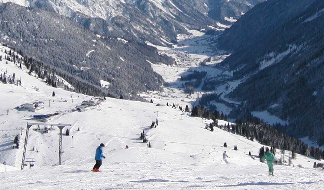
St. Anton est une porte d’entrée de Ski Arlberg, qui relie St. Anton, St. Christoph et Stuben à Lech, Oberlech, Zürs et Warth-Schröcken. La prévision pour St. Anton concerne donc un point de ce réseau, et non toutes les pistes à la fois.
Le point affiché par défaut sur cette page se situe à 1 304 m. Lors d’un épisode proche de la limite pluie-neige, il peut pleuvoir à cette altitude et neiger plus haut. Choisissez l’altitude où vous comptez skier, puis examinez température et isotherme zéro degré aux heures des précipitations. Un fort cumul annoncé en montagne ne décrit pas nécessairement les conditions près de votre hébergement.
Pour une journée entre plusieurs secteurs, consultez le plan officiel et l’état des remontées. Comparez GFS et ECMWF sur les mêmes heures : leurs divergences aident à apprécier l’incertitude d’une prévision de neige. Le cumul prévu désigne la neige fraîche, pas l’épaisseur déjà présente sur les pistes.
Sources officielles: Ski Arlberg. Informations vérifiées le 18 octobre 2026.
Provider panorama/video player. Capture time is shown by the camera.
Open camera page ↗
Provider panorama/video player. Capture time is shown by the camera.
Open camera page ↗
Provider panorama/video player. Capture time is shown by the camera.
Open camera page ↗ECMWF · Cycle du modèle : Prochaine mise à jour attendue :
Jour Heure (UTC) Temp. (°C) Humidité (%) Vent (km/h) Vent (nœuds) Vent (Bft) Direction Précip. (mm) Neige fraîche (cm) Pression (hPa) Isotherme 0 °C (m) Conditions | Mercredi, 04/11 06:00 -3.1 90 4 2 1B S — — 1021 < 2050 Partly cloudy 45% cloud 09:00 2.2 66 5 3 1B SE 0 0 1022 2345 Clear 7% cloud 12:00 4 53 6 3 2B SE 0.00 0 1021 2493 Clear 13% cloud 15:00 2.5 63 3 2 1B SE 0 0 1021 2417 Clear 16% cloud 18:00 -2.3 77 4 2 1B S 0 0 1023 < 2050 Clear 1% cloud 21:00 -3.4 84 5 3 1B S 0 0 1025 < 2050 Clear 1% cloud Jeudi, 05/11 00:00 -3.7 88 5 3 1B S 0 0 1025 < 2050 Clear 4% cloud 03:00 -4.2 88 6 3 1B S 0 0 1023 < 2050 Partly cloudy 31% cloud 06:00 -4.3 85 5 3 1B S 0 0 1022 < 2050 Partly cloudy 29% cloud 09:00 4.3 54 5 3 1B S 0 0 1023 2925 Clear 2% cloud 12:00 7 45 4 2 1B S 0 0 1022 2996 Clear 0% cloud 15:00 4.9 62 0 0 0B S 0 0 1022 2999 Clear 0% cloud 18:00 0 70 2 1 1B S 0 0 1023 2141 Clear 0% cloud 21:00 -1.2 74 3 2 1B S 0 0 1022 < 2050 Clear 7% cloud Vendredi, 06/11 00:00 -1.1 71 3 2 1B S 0 0 1021 < 2050 Clear 11% cloud 03:00 -1.1 70 3 1 1B S 0 0 1019 2986 Clear 0% cloud 06:00 -0.7 67 2 1 1B S 0 0 1018 3028 Partly cloudy 25% cloud 09:00 6.5 47 2 1 1B SE 0 0 1018 3096 Overcast 84% cloud 12:00 7.3 48 2 1 1B N 0 0 1017 3001 Overcast 85% cloud 15:00 3.2 76 1 1 1B N 0.55 0 1019 2764 Overcast 92% cloud 18:00 0.4 89 1 0 0B SE 0.40 0.1 1020 2219 Cloudy 73% cloud 21:00 -0.9 95 2 1 1B S 1.2 0.4 1021 < 2050 Overcast 95% cloud Samedi, 07/11 00:00 -1 98 2 1 1B S 0.59 0.2 1022 < 2050 Overcast 100% cloud 03:00 -1.6 98 1 0 0B SW 0.20 0 1021 < 2050 Overcast 100% cloud 06:00 -1.4 98 1 0 0B NE 0.51 0.2 1022 < 2050 Overcast 100% cloud 09:00 -0.5 93 1 1 1B E 1.4 0.4 1023 < 2050 Overcast 99% cloud 12:00 1 79 0 0 0B SE 0.12 0 1021 2210 Overcast 98% cloud 15:00 -0.1 87 1 1 0B N 0.06 0 1022 2068 Cloudy 73% cloud 18:00 -1.8 95 2 1 1B SE 0.13 0 1023 < 2050 Cloudy 71% cloud 21:00 -4.1 96 3 1 1B S 0.00 0 1023 < 2050 Cloudy 64% cloud Dimanche, 08/11 00:00 -2.5 94 2 1 1B S 0.06 0 1023 < 2050 Overcast 99% cloud 03:00 -2.9 93 3 1 1B S 0.90 0.9 1023 < 2050 Overcast 82% cloud 06:00 -4.7 91 3 2 1B S 0.12 0.1 1023 < 2050 Cloudy 68% cloud 09:00 -0.7 77 3 2 1B SW 0.05 0 1024 < 2050 Partly cloudy 33% cloud 12:00 1 62 5 3 1B SW 0 0 1023 2204 Clear 3% cloud 15:00 -0.6 67 2 1 1B SW 0 0 1022 < 2050 Clear 4% cloud 18:00 -5.6 79 3 2 1B S 0 0 1023 < 2050 Clear 2% cloud 21:00 -6.9 70 3 2 1B S 0 0 1022 < 2050 Clear 18% cloud Lundi, 09/11 00:00 -3.1 63 4 2 1B S 0 0 1020 < 2050 Overcast 98% cloud 03:00 -2.2 75 4 2 1B S 0.06 0 1019 < 2050 Overcast 94% cloud 06:00 -2.4 78 4 2 1B S 0.06 0 1019 < 2050 Overcast 95% cloud 09:00 2.3 63 5 3 1B S 0.00 0 1019 2577 Overcast 88% cloud 12:00 4.6 55 6 3 1B SW 0 0 1017 2766 Cloudy 72% cloud 15:00 2.5 69 5 3 1B S 0 0 1017 2606 Overcast 99% cloud 18:00 -0.3 83 7 4 2B S 0.06 0 1017 < 2050 Overcast 96% cloud 21:00 -0.3 90 8 4 2B S 0.13 0 1017 < 2050 Overcast 96% cloud Mardi, 10/11 00:00 0.3 92 8 4 2B S 0.25 0 1015 2505 Overcast 100% cloud 03:00 0.4 91 7 4 2B S 0 0 1014 2553 Overcast 94% cloud 06:00 0.5 91 8 4 2B S 0 0 1013 3043 Overcast 98% cloud |
|---|
Forecast table times: UTC.
Coordinates: 47.1308393°N, 10.2307545°E · Requested elevation: 2079 m. Model terrain: 2048 m. Terrain and 1000/925/850/700 hPa profiles are used for height estimates.
These are altitude estimates, not a simulation of local mountain terrain. Precipitation, cloud and sea-level pressure use horizontal interpolation only.
Precipitation includes rain and snow water equivalent: preceding 3 hours through day 6, then 6 hours (see cell tooltip). Snow (cm) estimates fresh snowfall from precipitation and temperature using the GFS conversion; it is not snow depth on the ground. Freezing (m) uses additional 600/500 hPa temperatures when available and estimates the lowest resolved 0°C crossing above sea level. When all sampled levels are warm, the upper profile limit is shown (see tooltip). < marks an entirely cold sampled profile and its lower height limit. No extrapolation is used.
Source: ECMWF · CC BY 4.0 · Processed by Snow Report.
ECMWF · Cycle du modèle : Prochaine mise à jour attendue :
Jour Heure (UTC) Temp. (°C) Humidité (%) Vent (km/h) Vent (nœuds) Vent (Bft) Direction Précip. (mm) Neige fraîche (cm) Pression (hPa) Isotherme 0 °C (m) Conditions | Mercredi, 04/11 06:00 -5.4 78 12 6 2B S — — 1021 < 1977 Partly cloudy 42% cloud 09:00 -3.8 63 14 7 3B SE 0 0 1021 2349 Clear 5% cloud 12:00 -3 66 18 10 3B S 0.01 0 1020 2498 Clear 11% cloud 15:00 -2.8 59 21 11 4B S 0 0 1021 2436 Clear 12% cloud 18:00 -3.2 54 20 11 3B S 0 0 1023 < 1977 Clear 1% cloud 21:00 -3.4 57 20 11 4B S 0 0 1024 < 1977 Clear 1% cloud Jeudi, 05/11 00:00 -3.2 61 17 9 3B S 0 0 1024 < 1977 Clear 3% cloud 03:00 -2.8 55 17 9 3B S 0 0 1023 < 1977 Partly cloudy 24% cloud 06:00 -2.1 47 15 8 3B S 0 0 1022 < 1977 Partly cloudy 24% cloud 09:00 0.7 41 14 8 3B S 0 0 1023 2940 Clear 2% cloud 12:00 1.5 45 15 8 3B SW 0 0 1022 3003 Clear 0% cloud 15:00 1.1 52 8 4 2B SW 0 0 1022 3006 Clear 0% cloud 18:00 -0.3 53 8 4 2B S 0 0 1022 2539 Clear 0% cloud 21:00 -0.4 50 11 6 2B S 0 0 1022 < 1977 Clear 7% cloud Vendredi, 06/11 00:00 -0.2 46 10 5 2B S 0 0 1021 < 1977 Clear 10% cloud 03:00 -0.1 46 9 5 2B S 0 0 1019 2898 Clear 0% cloud 06:00 -0 47 8 5 2B S 0 0 1018 2866 Partly cloudy 22% cloud 09:00 1.9 45 12 6 2B S 0 0 1018 3096 Overcast 83% cloud 12:00 1.5 51 11 6 2B S 0 0 1017 3002 Overcast 84% cloud 15:00 -0.3 72 15 8 3B SE 0.62 0.2 1019 2749 Overcast 92% cloud 18:00 -1.7 87 15 8 3B SE 0.38 0.1 1020 2216 Cloudy 80% cloud 21:00 -2.4 88 20 11 3B SE 1.3 0.4 1022 < 1977 Overcast 97% cloud Samedi, 07/11 00:00 -3.3 87 21 12 4B SE 0.61 0.6 1022 < 1977 Overcast 100% cloud 03:00 -4 90 13 7 3B S 0.22 0.2 1021 < 1977 Overcast 100% cloud 06:00 -4.5 96 10 5 2B SE 0.55 0.6 1022 < 1977 Overcast 100% cloud 09:00 -4.8 95 13 7 3B SE 1.5 1.5 1023 < 1977 Overcast 99% cloud 12:00 -4.5 87 17 9 3B S 0.13 0.1 1022 2168 Overcast 98% cloud 15:00 -5.1 91 17 9 3B S 0.07 0.1 1022 2028 Overcast 80% cloud 18:00 -5.4 81 14 8 3B S 0.15 0.2 1023 < 1977 Cloudy 76% cloud 21:00 -5.8 77 10 6 2B SW 0.01 0 1023 < 1977 Cloudy 61% cloud Dimanche, 08/11 00:00 -5.9 85 9 5 2B SW 0.05 0.1 1023 < 1977 Overcast 98% cloud 03:00 -6.3 87 13 7 3B SW 0.90 0.9 1023 < 1977 Cloudy 79% cloud 06:00 -7.1 83 15 8 3B SW 0.13 0.1 1023 < 1977 Cloudy 65% cloud 09:00 -6 78 13 7 3B SW 0.04 0 1024 1988 Partly cloudy 34% cloud 12:00 -5 53 14 7 3B SW 0 0 1023 2210 Clear 2% cloud 15:00 -5.2 46 15 8 3B W 0 0 1022 2007 Clear 3% cloud 18:00 -5.9 42 23 12 4B W 0 0 1023 < 1977 Clear 1% cloud 21:00 -5.5 50 27 15 4B W 0 0 1022 < 1977 Clear 15% cloud Lundi, 09/11 00:00 -4.1 74 22 12 4B W 0 0 1020 < 1977 Overcast 99% cloud 03:00 -3.2 78 30 16 5B W 0.08 0.1 1019 < 1977 Overcast 94% cloud 06:00 -2.9 81 27 15 4B W 0.08 0.1 1019 < 1977 Overcast 96% cloud 09:00 -1.1 64 29 16 5B W 0.01 0 1018 2588 Overcast 88% cloud 12:00 -0.3 58 26 14 4B SW 0 0 1017 2766 Cloudy 72% cloud 15:00 -0.9 75 28 15 4B W 0 0 1017 2622 Overcast 99% cloud 18:00 -1.2 84 32 17 5B SW 0.08 0 1017 2166 Overcast 97% cloud 21:00 -0.7 84 34 19 5B SW 0.13 0 1016 2136 Overcast 96% cloud Mardi, 10/11 00:00 -0.1 89 39 21 5B W 0.26 0.1 1015 2718 Overcast 100% cloud 03:00 -0.1 90 32 17 5B W 0 0 1014 2710 Overcast 95% cloud 06:00 0.3 86 24 13 4B SW 0 0 1012 3043 Overcast 98% cloud |
|---|
Forecast table times: UTC.
Coordinates: 47.1575711°N, 10.2130106°E · Requested elevation: 2805 m. Model terrain: 1974 m. Terrain and 1000/925/850/700 hPa profiles are used for height estimates.
These are altitude estimates, not a simulation of local mountain terrain. Precipitation, cloud and sea-level pressure use horizontal interpolation only.
Precipitation includes rain and snow water equivalent: preceding 3 hours through day 6, then 6 hours (see cell tooltip). Snow (cm) estimates fresh snowfall from precipitation and temperature using the GFS conversion; it is not snow depth on the ground. Freezing (m) uses additional 600/500 hPa temperatures when available and estimates the lowest resolved 0°C crossing above sea level. When all sampled levels are warm, the upper profile limit is shown (see tooltip). < marks an entirely cold sampled profile and its lower height limit. No extrapolation is used.
Source: ECMWF · CC BY 4.0 · Processed by Snow Report.
ECMWF · Cycle du modèle : Prochaine mise à jour attendue :
Jour Heure (UTC) Temp. (°C) Humidité (%) Vent (km/h) Vent (nœuds) Vent (Bft) Direction Précip. (mm) Neige fraîche (cm) Pression (hPa) Isotherme 0 °C (m) Conditions | Mercredi, 04/11 06:00 0.9 74 4 2 1B S — — 1021 < 2066 Partly cloudy 48% cloud 09:00 6.2 54 4 2 1B SE 0.00 0 1022 2342 Clear 7% cloud 12:00 8.1 44 6 3 1B SE 0.00 0 1021 2496 Clear 13% cloud 15:00 6.5 52 3 1 1B SE 0 0 1021 2418 Clear 15% cloud 18:00 1.5 65 3 2 1B S 0 0 1023 < 2066 Clear 1% cloud 21:00 0.4 70 4 2 1B S 0 0 1025 < 2066 Clear 1% cloud Jeudi, 05/11 00:00 0.2 73 5 2 1B S 0 0 1025 < 2066 Clear 4% cloud 03:00 -0.4 73 5 3 1B S 0 0 1023 < 2066 Partly cloudy 30% cloud 06:00 -0.5 71 5 2 1B S 0 0 1023 < 2066 Partly cloudy 29% cloud 09:00 8.2 46 4 2 1B S 0 0 1023 2921 Clear 1% cloud 12:00 11 38 3 2 1B S 0 0 1022 2995 Clear 0% cloud 15:00 8.9 52 0 0 0B SE 0 0 1022 3001 Clear 0% cloud 18:00 3.9 59 2 1 1B S 0 0 1023 < 2066 Clear 0% cloud 21:00 2.6 62 3 1 1B S 0 0 1022 < 2066 Clear 6% cloud Vendredi, 06/11 00:00 2.6 60 2 1 1B S 0 0 1021 < 2066 Clear 10% cloud 03:00 2.6 59 2 1 1B S 0 0 1019 2995 Clear 0% cloud 06:00 3 57 2 1 1B S 0 0 1018 3022 Partly cloudy 26% cloud 09:00 10.4 40 1 1 1B S 0 0 1018 3096 Cloudy 79% cloud 12:00 11.5 39 2 1 1B N 0 0 1017 3008 Overcast 83% cloud 15:00 7.5 61 2 1 1B N 0.53 0 1018 2786 Overcast 91% cloud 18:00 4.5 72 0 0 0B E 0.41 0 1020 2251 Cloudy 71% cloud 21:00 3 78 1 1 0B S 1.1 0 1021 < 2066 Overcast 94% cloud Samedi, 07/11 00:00 3 81 2 1 1B SW 0.45 0 1021 < 2066 Overcast 100% cloud 03:00 2.4 81 0 0 0B W 0.17 0 1021 < 2066 Overcast 100% cloud 06:00 2.7 80 1 1 0B NE 0.49 0 1022 < 2066 Overcast 100% cloud 09:00 3.7 76 1 1 0B E 1.2 0 1023 < 2066 Overcast 98% cloud 12:00 5.3 64 1 0 0B NE 0.12 0 1021 2235 Overcast 98% cloud 15:00 4.1 71 2 1 1B N 0.06 0 1022 2092 Cloudy 70% cloud 18:00 2.2 78 2 1 1B SE 0.12 0 1023 < 2066 Cloudy 71% cloud 21:00 -0 79 2 1 1B S 0 0 1023 < 2066 Cloudy 60% cloud Dimanche, 08/11 00:00 1.5 77 2 1 1B S 0.06 0 1023 < 2066 Overcast 100% cloud 03:00 1.1 77 2 1 1B S 0.87 0.3 1023 < 2066 Overcast 85% cloud 06:00 -0.8 75 3 1 1B S 0.15 0 1023 < 2066 Cloudy 67% cloud 09:00 3.4 63 3 2 1B SW 0.06 0 1024 < 2066 Partly cloudy 35% cloud 12:00 5.2 51 5 3 1B SW 0.00 0 1023 2214 Clear 5% cloud 15:00 3.5 55 1 1 1B SW 0 0 1022 < 2066 Clear 4% cloud 18:00 -1.5 65 3 2 1B S 0 0 1023 < 2066 Clear 2% cloud 21:00 -3 58 3 2 1B S 0 0 1022 < 2066 Clear 17% cloud Lundi, 09/11 00:00 0.8 51 4 2 1B S 0 0 1020 < 2066 Overcast 99% cloud 03:00 1.7 62 4 2 1B S 0.06 0 1020 < 2066 Overcast 93% cloud 06:00 1.4 64 3 2 1B S 0.06 0 1019 < 2066 Overcast 95% cloud 09:00 6.3 52 5 3 1B S 0.00 0 1019 2577 Overcast 89% cloud 12:00 8.7 46 5 3 1B S 0 0 1017 2771 Cloudy 72% cloud 15:00 6.6 57 5 3 1B S 0 0 1017 2611 Overcast 99% cloud 18:00 3.6 68 6 3 2B S 0.06 0 1017 < 2066 Overcast 96% cloud 21:00 3.6 74 7 4 2B S 0.11 0 1017 < 2066 Overcast 96% cloud Mardi, 10/11 00:00 4.1 76 8 4 2B S 0.24 0 1015 2442 Overcast 100% cloud 03:00 4.2 75 7 4 2B S 0 0 1014 2498 Overcast 94% cloud 06:00 4.4 75 7 4 2B S 0 0 1013 3044 Overcast 98% cloud |
|---|
Forecast table times: UTC.
Coordinates: 47.1274°N, 10.2674°E · Requested elevation: 1347 m. Model terrain: 2063 m. Terrain and 1000/925/850/700 hPa profiles are used for height estimates.
Outside the available profile, temperature uses an estimated 5.5°C/km height correction; wind retains the nearest available model-level value. Humidity is estimated with adjusted pressure and temperature.
These are altitude estimates, not a simulation of local mountain terrain. Precipitation, cloud and sea-level pressure use horizontal interpolation only.
Precipitation includes rain and snow water equivalent: preceding 3 hours through day 6, then 6 hours (see cell tooltip). Snow (cm) estimates fresh snowfall from precipitation and temperature using the GFS conversion; it is not snow depth on the ground. Freezing (m) uses additional 600/500 hPa temperatures when available and estimates the lowest resolved 0°C crossing above sea level. When all sampled levels are warm, the upper profile limit is shown (see tooltip). < marks an entirely cold sampled profile and its lower height limit. No extrapolation is used.