The peak of Ruka 360

Camera image unavailable
Camera image · refreshes every 60 seconds while visible.
Open camera page ↗
Cada color comienza en el valor indicado. Los colores del viento coinciden en las tres unidades. Las celdas sin precipitación permanecen neutras. Los colores describen los valores mostrados, no son avisos meteorológicos oficiales.
ECMWF · Ejecución del modelo: Próxima actualización prevista:
Día Hora (UTC) Temp. (°C) Humedad (%) Viento (km/h) Viento (nudos) Viento (Bft) Dirección Precip. (mm) Nieve nueva (cm) Presión (hPa) Isoterma de 0 °C (m) Condiciones | Miércoles, 04/11 06:00 -0.7 91 21 12 4B SW — — 1015 < 276 Overcast 100% cloud  09:00 1.5 98 19 10 3B SW 0.44 0 1012 1040 Overcast 100% cloud 12:00 2.4 96 19 10 3B W 0.28 0 1009 1449 Clear 18% cloud  15:00 2.1 97 20 11 4B W 0 0 1008 1227 Clear 0% cloud 18:00 1.7 89 23 12 4B W 0.01 0 1007 1058 Clear 0% cloud 21:00 1.9 74 29 15 4B W 0 0 1005 833 Cloudy 59% cloud  Jueves, 05/11 00:00 1.5 76 26 14 4B W 0 0 1005 674 Partly cloudy 24% cloud  03:00 1.1 80 23 12 4B NW 0 0 1006 495 Partly cloudy 47% cloud 06:00 0.4 78 22 12 4B NW 0 0 1007 359 Cloudy 79% cloud 09:00 0.9 74 21 11 4B NW 0 0 1009 411 Overcast 81% cloud 12:00 0.6 77 19 10 3B NW 0 0 1011 371 Clear 18% cloud 15:00 -0.8 84 19 10 3B NW 0 0 1013 < 276 Clear 19% cloud 18:00 -1.4 87 18 10 3B NW 0 0 1015 < 276 Clear 1% cloud 21:00 -1.7 84 19 10 3B NW 0 0 1017 < 276 Partly cloudy 25% cloud Viernes, 06/11 00:00 -1.7 80 21 12 4B NW 0 0 1019 < 276 Clear 9% cloud 03:00 -2 81 19 10 3B NW 0 0 1020 < 276 Clear 19% cloud 06:00 -2.1 84 16 9 3B NW 0 0 1021 < 276 Cloudy 55% cloud 09:00 -0.5 78 17 9 3B NW 0 0 1021 < 276 Overcast 98% cloud 12:00 0.1 78 14 7 3B NW 0 0 1020 297 Cloudy 78% cloud 15:00 -2.1 90 14 8 3B W 0 0 1019 < 276 Partly cloudy 36% cloud 18:00 -1.8 90 13 7 3B W 0.05 0 1017 < 276 Overcast 93% cloud 21:00 -0.6 87 15 8 3B W 0.03 0 1015 646 Overcast 100% cloud Sábado, 07/11 00:00 0.4 88 17 9 3B W 0.01 0 1012 1005 Overcast 95% cloud 03:00 0.5 91 14 7 3B W 0.09 0 1010 954 Cloudy 56% cloud 06:00 -0.3 96 15 8 3B W 0 0 1009 356 Partly cloudy 36% cloud 09:00 0.7 91 15 8 3B W 0 0 1008 1167 Partly cloudy 39% cloud 12:00 1 91 16 9 3B W 0 0 1007 1139 Cloudy 65% cloud 15:00 0.5 93 16 9 3B W 0 0 1007 871 Overcast 92% cloud 18:00 0 94 14 8 3B W 0 0 1007 284 Overcast 96% cloud 21:00 0.2 90 14 8 3B W 0 0 1008 647 Overcast 100% cloud Domingo, 08/11 00:00 -0.3 92 14 7 3B W 0 0 1008 557 Overcast 94% cloud 03:00 -0.9 94 13 7 3B W 0 0 1008 < 276 Overcast 100% cloud 06:00 -1.2 91 9 5 2B W 0 0 1009 464 Overcast 92% cloud 09:00 0 89 15 8 3B SW 0 0 1009 650 Overcast 82% cloud 12:00 0.5 88 16 8 3B SW 0 0 1008 1082 Overcast 95% cloud 15:00 1.4 94 18 10 3B SW 0 0 1007 1151 Cloudy 79% cloud 18:00 1.3 95 19 10 3B SW 0 0 1007 1382 Cloudy 74% cloud 21:00 1.7 92 20 11 4B SW 0 0 1006 1445 Overcast 92% cloud Lunes, 09/11 00:00 1.5 92 23 12 4B SW 0 0 1004 1407 Partly cloudy 37% cloud 03:00 1.4 93 24 13 4B SW 0 0 1003 1448 Cloudy 64% cloud 06:00 1.6 91 23 13 4B W 0 0 1003 1420 Overcast 83% cloud 09:00 2.6 87 24 13 4B W 0 0 1003 1157 Cloudy 56% cloud 12:00 2.7 87 22 12 4B W 0 0 1003 1230 Partly cloudy 33% cloud 15:00 1.9 91 21 11 4B W 0 0 1003 1202 Partly cloudy 32% cloud 18:00 1.4 95 19 10 3B W 0 0 1003 1035 Partly cloudy 21% cloud 21:00 1 97 18 10 3B W 0 0 1003 946 Cloudy 66% cloud Martes, 10/11 00:00 0.9 98 17 9 3B W 0.02 0 1004 828 Cloudy 75% cloud 03:00 0.7 100 15 8 3B W 0 0 1004 723 Overcast 100% cloud 06:00 1.1 99 13 7 3B W 0.09 0 1004 662 Overcast 100% cloud |
|---|
Forecast table times: UTC.
Coordinates: 66.177226°N, 29.1552302°E · Requested elevation: 286 m. Model terrain: 274 m. Terrain and 1000/925/850/700 hPa profiles are used for height estimates.
These are altitude estimates, not a simulation of local mountain terrain. Precipitation, cloud and sea-level pressure use horizontal interpolation only.
Precipitation includes rain and snow water equivalent: preceding 3 hours through day 6, then 6 hours (see cell tooltip). Snow (cm) estimates fresh snowfall from precipitation and temperature using the GFS conversion; it is not snow depth on the ground. Freezing (m) uses additional 600/500 hPa temperatures when available and estimates the lowest resolved 0°C crossing above sea level. When all sampled levels are warm, the upper profile limit is shown (see tooltip). < marks an entirely cold sampled profile and its lower height limit. No extrapolation is used.
Source: ECMWF · CC BY 4.0 · Processed by Snow Report.
Rukatunturi is a downhill ski area in Northern Ostrobothnia, Finland. Mapped terrain includes beginner, easy, intermediate, advanced routes. Its mapped lift network extends from approximately 286 to 494 metres above sea level. Cross-country skiing is also mapped within the area.
Data: OpenSkiData / OpenSkiMap, OpenStreetMap contributors (ODbL), Skimap.org, Who's On First, Mapterhorn.
Camera image · refreshes every 60 seconds while visible.
Open camera page ↗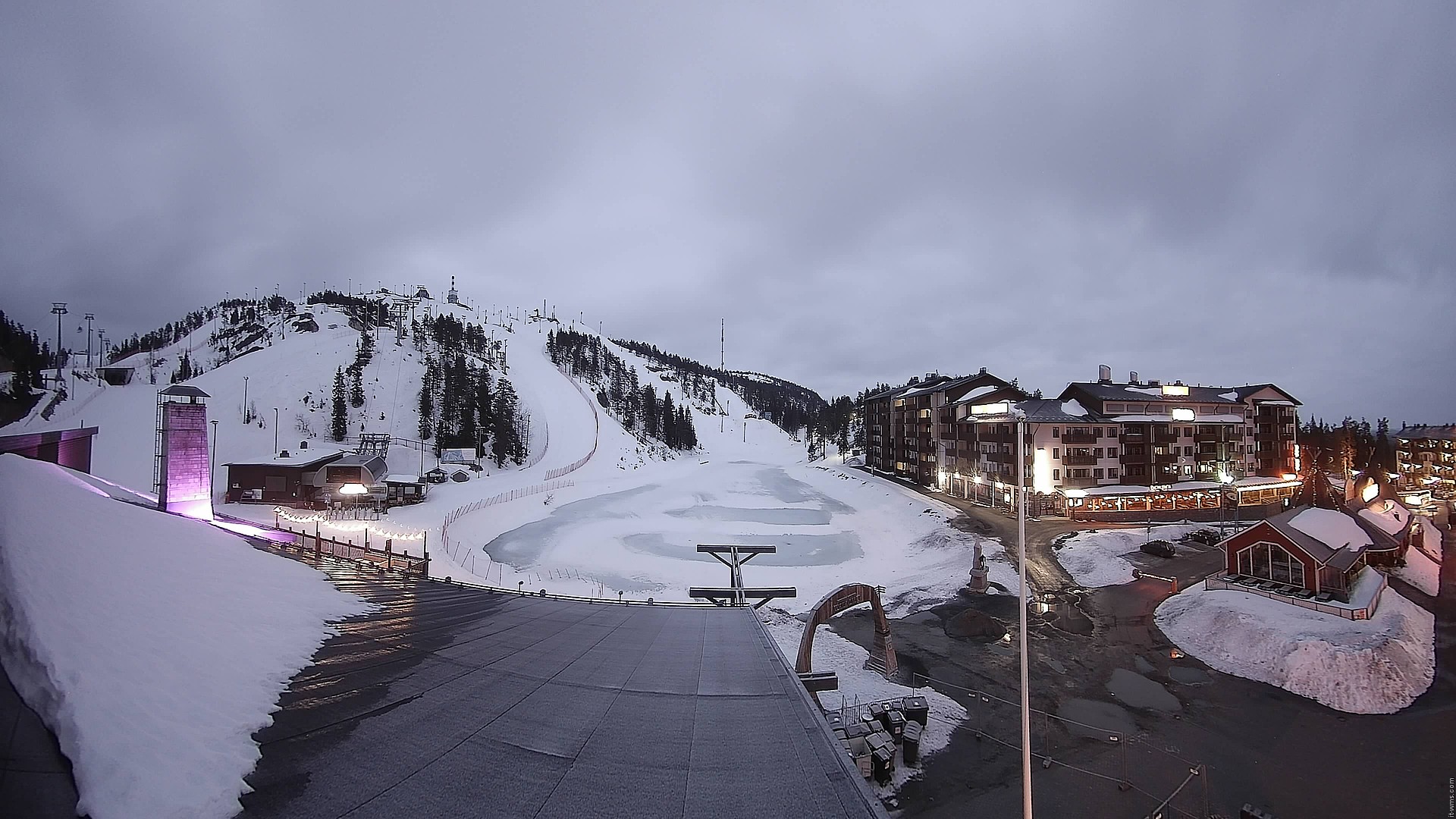
Camera image · refreshes every 60 seconds while visible.
Open camera page ↗
Camera image · refreshes every 60 seconds while visible.
Open camera page ↗ECMWF · Ejecución del modelo: Próxima actualización prevista:
Día Hora (UTC) Temp. (°C) Humedad (%) Viento (km/h) Viento (nudos) Viento (Bft) Dirección Precip. (mm) Nieve nueva (cm) Presión (hPa) Isoterma de 0 °C (m) Condiciones | Miércoles, 04/11 06:00 -0.8 91 24 13 4B SW — — 1015 < 277 Overcast 100% cloud 09:00 1.4 98 22 12 4B SW 0.44 0 1012 1037 Overcast 100% cloud 12:00 2.5 95 22 12 4B W 0.28 0 1009 1446 Clear 18% cloud 15:00 2.2 96 24 13 4B W 0 0 1008 1228 Clear 0% cloud 18:00 1.8 87 26 14 4B W 0.01 0 1007 1059 Clear 0% cloud 21:00 1.8 74 33 18 5B W 0 0 1005 833 Cloudy 59% cloud Jueves, 05/11 00:00 1.4 76 30 16 5B W 0 0 1005 675 Partly cloudy 25% cloud 03:00 0.9 80 26 14 4B NW 0 0 1006 494 Partly cloudy 49% cloud 06:00 0.2 78 25 14 4B NW 0 0 1007 361 Cloudy 79% cloud 09:00 0.7 75 24 13 4B NW 0 0 1009 412 Overcast 81% cloud 12:00 0.4 77 22 12 4B NW 0 0 1011 372 Clear 18% cloud 15:00 -0.9 84 22 12 4B NW 0 0 1013 < 277 Clear 18% cloud 18:00 -1.6 87 21 12 4B NW 0 0 1015 < 277 Clear 1% cloud 21:00 -1.9 84 22 12 4B NW 0 0 1017 < 277 Partly cloudy 25% cloud Viernes, 06/11 00:00 -1.9 80 24 13 4B NW 0 0 1019 < 277 Clear 9% cloud 03:00 -2.1 81 22 12 4B NW 0 0 1020 < 277 Clear 19% cloud 06:00 -2.2 84 19 10 3B NW 0 0 1021 < 277 Cloudy 56% cloud 09:00 -0.8 78 19 10 3B NW 0 0 1021 < 277 Overcast 98% cloud 12:00 -0.2 78 15 8 3B NW 0 0 1020 297 Cloudy 78% cloud 15:00 -2.1 89 15 8 3B W 0 0 1019 < 277 Partly cloudy 36% cloud 18:00 -1.8 90 14 8 3B W 0.06 0 1017 < 277 Overcast 93% cloud 21:00 -0.6 87 17 9 3B W 0.03 0 1015 655 Overcast 100% cloud Sábado, 07/11 00:00 0.5 87 20 11 3B W 0.01 0 1012 1005 Overcast 96% cloud 03:00 0.5 90 16 9 3B W 0.08 0 1010 951 Cloudy 57% cloud 06:00 -0.2 94 17 9 3B W 0 0 1009 360 Partly cloudy 36% cloud 09:00 0.8 89 17 9 3B W 0 0 1008 1165 Partly cloudy 38% cloud 12:00 1 90 18 10 3B W 0 0 1007 1146 Cloudy 64% cloud 15:00 0.5 92 19 10 3B W 0 0 1007 872 Overcast 91% cloud 18:00 0.1 93 17 9 3B NW 0 0 1007 292 Overcast 96% cloud 21:00 0.2 89 17 9 3B NW 0 0 1008 623 Overcast 100% cloud Domingo, 08/11 00:00 -0.3 91 16 9 3B W 0 0 1008 566 Overcast 94% cloud 03:00 -0.9 93 15 8 3B W 0 0 1008 < 277 Overcast 100% cloud 06:00 -1 89 12 6 2B W 0 0 1009 468 Overcast 92% cloud 09:00 0 88 17 9 3B SW 0 0 1009 567 Overcast 82% cloud 12:00 0.6 87 18 10 3B SW 0 0 1008 1080 Overcast 95% cloud 15:00 1.4 93 21 11 4B W 0 0 1007 1146 Cloudy 79% cloud 18:00 1.4 94 22 12 4B W 0 0 1007 1381 Cloudy 74% cloud 21:00 1.8 91 23 12 4B W 0 0 1006 1445 Overcast 92% cloud Lunes, 09/11 00:00 1.5 91 26 14 4B W 0 0 1004 1404 Partly cloudy 37% cloud 03:00 1.4 93 27 15 4B W 0 0 1003 1448 Cloudy 64% cloud 06:00 1.5 90 27 15 4B W 0 0 1003 1421 Overcast 84% cloud 09:00 2.5 87 27 15 4B W 0 0 1003 1157 Cloudy 56% cloud 12:00 2.6 87 26 14 4B W 0 0 1003 1232 Partly cloudy 33% cloud 15:00 1.9 91 25 13 4B W 0 0 1003 1207 Partly cloudy 31% cloud 18:00 1.4 94 23 12 4B W 0 0 1003 1034 Partly cloudy 21% cloud 21:00 1 97 21 11 4B W 0 0 1003 946 Cloudy 67% cloud Martes, 10/11 00:00 0.9 97 19 10 3B W 0.03 0 1004 828 Cloudy 76% cloud 03:00 0.7 99 17 9 3B W 0 0 1004 725 Overcast 100% cloud 06:00 1 99 16 8 3B W 0.08 0 1004 663 Overcast 100% cloud |
|---|
Forecast table times: UTC.
Coordinates: 66.1704548°N, 29.1692555°E · Requested elevation: 318 m. Model terrain: 275 m. Terrain and 1000/925/850/700 hPa profiles are used for height estimates.
These are altitude estimates, not a simulation of local mountain terrain. Precipitation, cloud and sea-level pressure use horizontal interpolation only.
Precipitation includes rain and snow water equivalent: preceding 3 hours through day 6, then 6 hours (see cell tooltip). Snow (cm) estimates fresh snowfall from precipitation and temperature using the GFS conversion; it is not snow depth on the ground. Freezing (m) uses additional 600/500 hPa temperatures when available and estimates the lowest resolved 0°C crossing above sea level. When all sampled levels are warm, the upper profile limit is shown (see tooltip). < marks an entirely cold sampled profile and its lower height limit. No extrapolation is used.
Source: ECMWF · CC BY 4.0 · Processed by Snow Report.
ECMWF · Ejecución del modelo: Próxima actualización prevista:
Día Hora (UTC) Temp. (°C) Humedad (%) Viento (km/h) Viento (nudos) Viento (Bft) Dirección Precip. (mm) Nieve nueva (cm) Presión (hPa) Isoterma de 0 °C (m) Condiciones | Miércoles, 04/11 06:00 -0.7 93 41 22 6B SW — — 1016 < 278 Overcast 100% cloud 09:00 1.1 98 39 21 5B W 0.44 0.1 1012 1040 Overcast 100% cloud 12:00 2.9 88 40 21 6B W 0.28 0 1009 1450 Clear 18% cloud 15:00 2.8 89 45 24 6B NW 0 0 1008 1228 Clear 0% cloud 18:00 2.1 71 47 26 6B NW 0.01 0 1007 1059 Clear 0% cloud 21:00 1.4 70 57 31 7B W 0 0 1005 833 Cloudy 60% cloud Jueves, 05/11 00:00 0.7 76 50 27 7B NW 0 0 1005 676 Partly cloudy 25% cloud 03:00 -0 81 45 24 6B NW 0 0 1006 496 Partly cloudy 48% cloud 06:00 -0.7 79 45 24 6B NW 0 0 1007 363 Cloudy 78% cloud 09:00 -0.6 77 42 23 6B NW 0 0 1009 411 Overcast 80% cloud 12:00 -0.9 80 39 21 6B NW 0 0 1011 373 Clear 18% cloud 15:00 -1.8 85 41 22 6B N 0 0 1013 < 278 Clear 18% cloud 18:00 -2.4 86 40 21 6B NW 0 0 1015 < 278 Clear 1% cloud 21:00 -2.9 85 40 22 6B NW 0 0 1017 < 278 Partly cloudy 24% cloud Viernes, 06/11 00:00 -3 80 42 23 6B NW 0 0 1019 < 278 Clear 9% cloud 03:00 -3.1 82 38 21 5B NW 0 0 1020 < 278 Clear 19% cloud 06:00 -3.1 85 32 18 5B NW 0 0 1021 < 278 Cloudy 56% cloud 09:00 -2 82 33 18 5B NW 0 0 1021 < 278 Overcast 98% cloud 12:00 -1.3 80 24 13 4B NW 0 0 1020 295 Cloudy 78% cloud 15:00 -2.3 84 25 13 4B NW 0 0 1019 < 278 Partly cloudy 37% cloud 18:00 -1.6 88 26 14 4B NW 0.05 0 1017 < 278 Overcast 93% cloud 21:00 -0.3 86 32 17 5B NW 0.03 0 1015 651 Overcast 100% cloud Sábado, 07/11 00:00 0.9 84 37 20 5B NW 0.02 0 1012 1007 Overcast 95% cloud 03:00 0.7 87 32 17 5B NW 0.08 0 1010 954 Cloudy 58% cloud 06:00 0.6 87 31 17 5B NW 0 0 1009 360 Partly cloudy 36% cloud 09:00 1.7 81 33 18 5B W 0 0 1008 1167 Partly cloudy 38% cloud 12:00 1.2 85 34 18 5B W 0 0 1007 1144 Cloudy 64% cloud 15:00 0.7 84 37 20 5B NW 0 0 1007 875 Overcast 91% cloud 18:00 0.4 86 34 19 5B NW 0 0 1007 297 Overcast 96% cloud 21:00 0.1 84 34 18 5B NW 0 0 1008 650 Overcast 100% cloud Domingo, 08/11 00:00 -0.1 84 33 18 5B NW 0 0 1008 558 Overcast 94% cloud 03:00 -0.7 87 31 17 5B NW 0 0 1008 < 278 Overcast 99% cloud 06:00 0.2 78 27 15 4B NW 0 0 1009 466 Overcast 92% cloud 09:00 0 82 28 15 4B W 0 0 1009 701 Overcast 82% cloud 12:00 1.1 82 33 18 5B W 0 0 1008 1082 Overcast 95% cloud 15:00 1.4 91 39 21 5B W 0 0 1007 1156 Cloudy 80% cloud 18:00 1.9 86 39 21 6B W 0 0 1007 1380 Cloudy 74% cloud 21:00 2 84 42 22 6B W 0 0 1006 1444 Overcast 92% cloud Lunes, 09/11 00:00 1.4 88 47 25 6B W 0 0 1005 1403 Partly cloudy 37% cloud 03:00 1.2 90 49 27 6B W 0 0 1003 1449 Cloudy 64% cloud 06:00 1.4 87 50 27 6B W 0 0 1003 1422 Overcast 83% cloud 09:00 1.9 88 49 27 6B W 0 0 1003 1163 Cloudy 56% cloud 12:00 2 87 47 25 6B W 0 0 1003 1243 Partly cloudy 32% cloud 15:00 1.7 89 46 25 6B W 0 0 1003 1214 Partly cloudy 31% cloud 18:00 1.3 92 42 23 6B W 0 0 1003 1042 Partly cloudy 21% cloud 21:00 1 94 38 20 5B W 0 0 1003 949 Cloudy 68% cloud Martes, 10/11 00:00 0.9 95 34 18 5B W 0.02 0 1004 828 Cloudy 76% cloud 03:00 0.5 98 31 17 5B W 0 0 1004 726 Overcast 100% cloud 06:00 0.5 100 29 16 5B W 0.08 0 1004 664 Overcast 100% cloud |
|---|
Forecast table times: UTC.
Coordinates: 66.1658172°N, 29.1513773°E · Requested elevation: 494 m. Model terrain: 275 m. Terrain and 1000/925/850/700 hPa profiles are used for height estimates.
These are altitude estimates, not a simulation of local mountain terrain. Precipitation, cloud and sea-level pressure use horizontal interpolation only.
Precipitation includes rain and snow water equivalent: preceding 3 hours through day 6, then 6 hours (see cell tooltip). Snow (cm) estimates fresh snowfall from precipitation and temperature using the GFS conversion; it is not snow depth on the ground. Freezing (m) uses additional 600/500 hPa temperatures when available and estimates the lowest resolved 0°C crossing above sea level. When all sampled levels are warm, the upper profile limit is shown (see tooltip). < marks an entirely cold sampled profile and its lower height limit. No extrapolation is used.