Previsiones para estaciones de esquí de todo el mundo

Guía de colores Temperatura · Viento · Lluvia · Nieve
Cada color comienza en el valor indicado. Los colores del viento coinciden en las tres unidades. Las celdas sin precipitación permanecen neutras. Los colores describen los valores mostrados, no son avisos meteorológicos oficiales.
Prince Hotels and Resorts Karuizawa - Low lift station
ECMWF · Ejecución del modelo: Próxima actualización prevista:
Día Hora (UTC) Temp. (°C) Humedad (%) Viento (km/h) Viento (nudos) Viento (Bft) Dirección Precip. (mm) Nieve nueva (cm) Presión (hPa) Isoterma de 0 °C (m) Condiciones | Miércoles, 04/11 12:00 7.4 98 9 5 2B E — — 1029 3061 Overcast 100% cloud  15:00 7.3 98 7 4 2B E 5.3 0 1027 3138 Overcast 100% cloud 18:00 7.5 98 5 3 1B E 4.5 0 1024 3131 Overcast 100% cloud 21:00 8 98 4 2 1B E 2.1 0 1022 3117 Overcast 100% cloud Jueves, 05/11 00:00 10.3 94 7 4 2B SE 0.05 0 1019 3104 Overcast 100% cloud 03:00 13.2 79 3 2 1B S 0.09 0 1014 3075 Overcast 97% cloud 06:00 14.3 75 3 2 1B SE 0.04 0 1011 3055 Partly cloudy 41% cloud  09:00 9.9 92 3 2 1B W 0 0 1010 3047 Cloudy 53% cloud  12:00 8.5 95 3 2 1B W 0 0 1008 3033 Cloudy 51% cloud 15:00 7.6 95 5 3 1B W 0 0 1005 3016 Cloudy 66% cloud 18:00 7.5 92 9 5 2B W 0.14 0 1003 2999 Cloudy 56% cloud 21:00 7.6 93 10 6 2B W 0.52 0 1004 2999 Partly cloudy 42% cloud Viernes, 06/11 00:00 14 76 11 6 2B W 0.06 0 1007 3014 Partly cloudy 37% cloud 03:00 17 43 22 12 4B W 0.04 0 1006 3014 Clear 13% cloud  06:00 16.3 40 19 11 3B W 0 0 1007 3020 Partly cloudy 22% cloud 09:00 11 59 13 7 3B W 0 0 1010 3002 Partly cloudy 22% cloud 12:00 8.2 68 13 7 3B W 0 0 1012 2689 Partly cloudy 20% cloud 15:00 6.2 76 10 6 2B W 0.02 0 1014 2206 Partly cloudy 34% cloud 18:00 5.2 79 12 7 3B W 0.04 0 1015 1928 Partly cloudy 49% cloud 21:00 4.8 75 12 6 2B W 0 0 1017 1766 Cloudy 63% cloud Sábado, 07/11 00:00 7.7 57 15 8 3B W 0.05 0 1019 1939 Cloudy 60% cloud 03:00 8.8 46 23 12 4B W 0.04 0 1020 2006 Partly cloudy 50% cloud 06:00 7.5 47 22 12 4B W 0 0 1021 1833 Partly cloudy 48% cloud 09:00 4.1 58 16 9 3B W 0 0 1024 1587 Partly cloudy 26% cloud 12:00 2.5 66 11 6 2B W 0 0 1027 1568 Partly cloudy 28% cloud 15:00 1.5 69 11 6 2B W 0 0 1028 1538 Partly cloudy 34% cloud 18:00 0.7 75 9 5 2B W 0 0 1029 1304 Partly cloudy 34% cloud 21:00 0.7 76 10 5 2B W 0 0 1031 1383 Cloudy 64% cloud Domingo, 08/11 00:00 4.9 60 11 6 2B W 0 0 1032 2113 Cloudy 77% cloud 03:00 8.9 46 8 4 2B NW 0 0 1029 2557 Cloudy 66% cloud 06:00 8.2 51 5 3 1B NW 0 0 1028 2515 Partly cloudy 35% cloud 09:00 4.2 72 3 2 1B W 0.02 0 1030 2201 Cloudy 65% cloud 12:00 2.7 79 2 1 1B W 0 0 1031 2174 Cloudy 71% cloud 15:00 3.1 76 1 0 0B SW 0 0 1029 2165 Overcast 82% cloud 18:00 2.8 76 1 1 0B W 0 0 1028 2053 Overcast 95% cloud 21:00 3.3 76 2 1 1B SW 0 0 1027 2203 Overcast 96% cloud Lunes, 09/11 00:00 6.1 68 1 1 0B S 0.16 0 1026 2442 Overcast 90% cloud 03:00 8.8 61 2 1 1B SE 0 0 1021 2577 Clear 17% cloud 06:00 9.1 66 3 2 1B E 0 0 1019 2426 Cloudy 80% cloud 09:00 5.8 87 2 1 1B NW 0.32 0 1021 2289 Cloudy 74% cloud 12:00 4.6 92 9 5 2B W 0.80 0 1022 1949 Cloudy 75% cloud 15:00 3.1 86 14 7 3B W 0 0 1022 1588 Cloudy 58% cloud 18:00 1.9 80 12 6 2B W 0 0 1023 1550 Partly cloudy 34% cloud 21:00 0.8 79 12 6 2B W 0 0 1024 1272 Partly cloudy 29% cloud Martes, 10/11 00:00 3.8 62 15 8 3B W 0 0 1025 1325 Partly cloudy 36% cloud 03:00 5.7 52 12 7 2B NW 0 0 1024 1424 Partly cloudy 27% cloud 06:00 5 48 10 6 2B NW 0 0 1025 1431 Clear 12% cloud 09:00 0.2 72 5 3 1B W 0 0 1028 1035 Clear 11% cloud 12:00 -1.5 77 5 3 1B W 0 0 1029 < 824 Clear 2% cloud 18:00 -2 76 2 1 1B W 0 0 1030 < 824 Clear 1% cloud Miércoles, 11/11 00:00 4.2 56 2 1 1B E 0 0 1030 2126 Clear 0% cloud 06:00 8.2 54 4 2 1B E 0 0 1026 2670 Clear 0% cloud 12:00 2.1 79 2 1 1B SE 0 0 1029 2608 Clear 0% cloud 18:00 1.1 75 2 1 1B SW 0 0 1027 2701 Clear 0% cloud Jueves, 12/11 00:00 8.8 51 1 0 0B E 0 0 1027 2751 Clear 0% cloud 06:00 11.3 49 4 2 1B E 0 0 1023 2774 Clear 0% cloud 12:00 4.3 74 2 1 1B W 0 0 1024 2853 Clear 0% cloud 18:00 2.8 68 4 2 1B W 0 0 1022 2861 Clear 0% cloud Viernes, 13/11 00:00 10.3 43 2 1 1B W 0 0 1021 3013 Clear 0% cloud 06:00 13.3 39 2 1 1B NE 0 0 1017 2871 Clear 0% cloud 12:00 4.1 76 5 3 1B W 0 0 1018 2360 Clear 0% cloud 18:00 2.3 68 10 5 2B W 0 0 1017 1832 Clear 15% cloud Sábado, 14/11 00:00 8.4 64 12 7 3B W 0 0 1021 3023 Clear 16% cloud 06:00 11.2 45 7 4 2B W 0 0 1020 3087 Clear 3% cloud 12:00 3.1 80 4 2 1B W 0 0 1023 3103 Cloudy 58% cloud |
|---|
Forecast notes
Forecast table times: UTC.
Coordinates: 36.3368991°N, 138.6378567°E · Requested elevation: 941 m. Model terrain: 822 m. Terrain and 1000/925/850/700 hPa profiles are used for height estimates.
These are altitude estimates, not a simulation of local mountain terrain. Precipitation, cloud and sea-level pressure use horizontal interpolation only.
Precipitation includes rain and snow water equivalent: preceding 3 hours through day 6, then 6 hours (see cell tooltip). Snow (cm) estimates fresh snowfall from precipitation and temperature using the GFS conversion; it is not snow depth on the ground. Freezing (m) uses additional 600/500 hPa temperatures when available and estimates the lowest resolved 0°C crossing above sea level. When all sampled levels are warm, the upper profile limit is shown (see tooltip). < marks an entirely cold sampled profile and its lower height limit. No extrapolation is used.
Source: ECMWF · CC BY 4.0 · Processed by Snow Report.
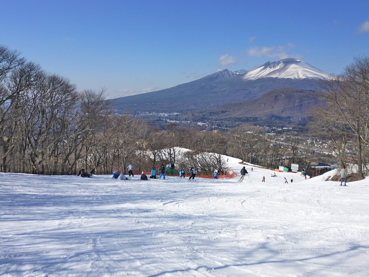
Prince Hotels and Resorts Karuizawa is a downhill ski area in Gunma Prefecture, Japan. Mapped terrain includes easy, intermediate, advanced routes. Its mapped lift network extends from approximately 941 to 1156 metres above sea level.
Data: OpenSkiData / OpenSkiMap, OpenStreetMap contributors (ODbL), Skimap.org, Who's On First, Mapterhorn.
Prince Hotels and Resorts Karuizawa - Base lift station
ECMWF · Ejecución del modelo: Próxima actualización prevista:
Día Hora (UTC) Temp. (°C) Humedad (%) Viento (km/h) Viento (nudos) Viento (Bft) Dirección Precip. (mm) Nieve nueva (cm) Presión (hPa) Isoterma de 0 °C (m) Condiciones | Miércoles, 04/11 12:00 7.4 98 9 5 2B E — — 1029 3061 Overcast 100% cloud 15:00 7.3 98 7 4 2B E 5.3 0 1027 3138 Overcast 100% cloud 18:00 7.5 97 5 3 1B E 4.5 0 1024 3131 Overcast 100% cloud 21:00 7.9 98 4 2 1B E 2.1 0 1022 3117 Overcast 100% cloud Jueves, 05/11 00:00 10.3 94 7 4 2B SE 0.05 0 1019 3104 Overcast 100% cloud 03:00 13.1 79 3 2 1B S 0.09 0 1014 3075 Overcast 97% cloud 06:00 14.2 74 3 1 1B SE 0.04 0 1011 3055 Partly cloudy 41% cloud 09:00 9.9 92 3 2 1B W 0 0 1010 3047 Cloudy 53% cloud 12:00 8.5 95 4 2 1B W 0 0 1008 3033 Cloudy 51% cloud 15:00 7.6 95 6 3 1B W 0 0 1005 3016 Cloudy 66% cloud 18:00 7.5 92 9 5 2B W 0.14 0 1003 2999 Cloudy 55% cloud 21:00 7.5 93 11 6 2B W 0.52 0 1004 2999 Partly cloudy 42% cloud Viernes, 06/11 00:00 14 76 12 6 2B W 0.06 0 1007 3014 Partly cloudy 36% cloud 03:00 16.9 43 22 12 4B W 0.03 0 1006 3014 Clear 13% cloud 06:00 16.3 40 20 11 3B W 0 0 1007 3020 Partly cloudy 22% cloud 09:00 10.9 59 13 7 3B W 0 0 1010 3002 Partly cloudy 22% cloud 12:00 8.2 68 13 7 3B W 0 0 1012 2689 Partly cloudy 20% cloud 15:00 6.2 76 11 6 2B W 0.02 0 1014 2206 Partly cloudy 34% cloud 18:00 5.2 79 12 7 3B W 0.04 0 1015 1929 Partly cloudy 49% cloud 21:00 4.7 75 12 7 3B W 0 0 1017 1766 Cloudy 62% cloud Sábado, 07/11 00:00 7.7 57 15 8 3B W 0.05 0 1019 1940 Cloudy 59% cloud 03:00 8.8 46 23 12 4B W 0.04 0 1020 2008 Partly cloudy 49% cloud 06:00 7.4 47 22 12 4B W 0 0 1021 1833 Partly cloudy 48% cloud 09:00 4 58 16 9 3B W 0 0 1024 1588 Partly cloudy 26% cloud 12:00 2.4 66 12 6 2B W 0 0 1027 1569 Partly cloudy 28% cloud 15:00 1.5 69 11 6 2B W 0 0 1028 1538 Partly cloudy 34% cloud 18:00 0.7 74 9 5 2B W 0 0 1029 1308 Partly cloudy 34% cloud 21:00 0.7 75 10 5 2B W 0 0 1031 1385 Cloudy 64% cloud Domingo, 08/11 00:00 4.9 60 11 6 2B W 0 0 1032 2109 Cloudy 76% cloud 03:00 8.8 46 8 4 2B NW 0 0 1029 2554 Cloudy 65% cloud 06:00 8.1 51 5 3 1B NW 0 0 1028 2513 Partly cloudy 35% cloud 09:00 4.1 72 3 2 1B W 0.02 0 1030 2199 Cloudy 65% cloud 12:00 2.7 79 2 1 1B W 0 0 1031 2172 Cloudy 71% cloud 15:00 3 76 1 0 0B SW 0 0 1029 2163 Overcast 82% cloud 18:00 2.8 76 1 1 1B W 0 0 1028 2051 Overcast 95% cloud 21:00 3.3 76 2 1 1B SW 0 0 1027 2203 Overcast 96% cloud Lunes, 09/11 00:00 6.1 68 1 1 1B SW 0.16 0 1026 2442 Overcast 90% cloud 03:00 8.7 61 2 1 1B SE 0 0 1021 2576 Clear 18% cloud 06:00 9 66 3 1 1B E 0 0 1019 2425 Cloudy 80% cloud 09:00 5.8 87 3 1 1B NW 0.33 0 1021 2288 Cloudy 74% cloud 12:00 4.6 92 9 5 2B W 0.82 0 1022 1948 Cloudy 75% cloud 15:00 3 86 14 7 3B NW 0 0 1022 1589 Cloudy 57% cloud 18:00 1.9 80 12 6 2B W 0 0 1023 1551 Partly cloudy 35% cloud 21:00 0.8 79 12 7 2B W 0 0 1024 1274 Partly cloudy 29% cloud Martes, 10/11 00:00 3.8 63 15 8 3B W 0 0 1025 1325 Partly cloudy 36% cloud 03:00 5.6 52 12 7 2B NW 0 0 1024 1423 Partly cloudy 27% cloud 06:00 4.9 49 10 6 2B NW 0 0 1025 1430 Clear 12% cloud 09:00 0.2 72 5 3 1B W 0 0 1028 1037 Clear 11% cloud 12:00 -1.4 77 5 3 1B W 0 0 1029 < 823 Clear 2% cloud 18:00 -2 76 2 1 1B W 0 0 1030 < 823 Clear 1% cloud Miércoles, 11/11 00:00 4.2 56 2 1 1B E 0 0 1030 2124 Clear 0% cloud 06:00 8.2 54 4 2 1B E 0 0 1026 2670 Clear 0% cloud 12:00 2.2 79 2 1 1B SE 0 0 1029 2607 Clear 0% cloud 18:00 1.2 75 2 1 1B SW 0 0 1027 2701 Clear 0% cloud Jueves, 12/11 00:00 8.8 50 1 0 0B SE 0 0 1027 2750 Clear 0% cloud 06:00 11.3 49 4 2 1B E 0 0 1023 2774 Clear 0% cloud 12:00 4.3 74 2 1 1B W 0 0 1024 2853 Clear 0% cloud 18:00 2.8 68 4 2 1B W 0 0 1022 2861 Clear 0% cloud Viernes, 13/11 00:00 10.3 43 2 1 1B W 0 0 1021 3013 Clear 0% cloud 06:00 13.2 39 2 1 1B NE 0 0 1017 2871 Clear 0% cloud 12:00 4 75 6 3 1B W 0 0 1018 2359 Clear 0% cloud 18:00 2.3 68 10 6 2B W 0 0 1017 1829 Clear 15% cloud Sábado, 14/11 00:00 8.4 64 13 7 3B W 0 0 1021 3022 Clear 16% cloud 06:00 11.2 45 7 4 2B W 0 0 1020 3087 Clear 3% cloud 12:00 3.1 80 4 2 1B W 0 0 1023 3103 Cloudy 58% cloud |
|---|
Forecast notes
Forecast table times: UTC.
Coordinates: 36.3389802°N, 138.640202°E · Requested elevation: 950 m. Model terrain: 821 m. Terrain and 1000/925/850/700 hPa profiles are used for height estimates.
These are altitude estimates, not a simulation of local mountain terrain. Precipitation, cloud and sea-level pressure use horizontal interpolation only.
Precipitation includes rain and snow water equivalent: preceding 3 hours through day 6, then 6 hours (see cell tooltip). Snow (cm) estimates fresh snowfall from precipitation and temperature using the GFS conversion; it is not snow depth on the ground. Freezing (m) uses additional 600/500 hPa temperatures when available and estimates the lowest resolved 0°C crossing above sea level. When all sampled levels are warm, the upper profile limit is shown (see tooltip). < marks an entirely cold sampled profile and its lower height limit. No extrapolation is used.
Source: ECMWF · CC BY 4.0 · Processed by Snow Report.
Prince Hotels and Resorts Karuizawa - Top lift station
ECMWF · Ejecución del modelo: Próxima actualización prevista:
Día Hora (UTC) Temp. (°C) Humedad (%) Viento (km/h) Viento (nudos) Viento (Bft) Dirección Precip. (mm) Nieve nueva (cm) Presión (hPa) Isoterma de 0 °C (m) Condiciones | Miércoles, 04/11 12:00 6.6 98 17 9 3B SE — — 1029 3061 Overcast 100% cloud 15:00 6.6 98 13 7 3B SE 5.3 0 1027 3138 Overcast 100% cloud 18:00 7.1 95 11 6 2B SE 4.6 0 1024 3131 Overcast 100% cloud 21:00 7.5 98 11 6 2B E 2.2 0 1022 3117 Overcast 100% cloud Jueves, 05/11 00:00 9.2 96 13 7 3B SE 0.05 0 1019 3104 Overcast 100% cloud 03:00 12.1 78 9 5 2B SW 0.08 0 1014 3075 Overcast 96% cloud 06:00 13.2 74 7 4 2B SW 0.05 0 1011 3055 Partly cloudy 41% cloud 09:00 9.4 89 10 5 2B W 0 0 1010 3047 Cloudy 52% cloud 12:00 8.1 93 10 5 2B W 0 0 1008 3033 Partly cloudy 50% cloud 15:00 7.2 93 12 7 3B W 0 0 1005 3016 Cloudy 67% cloud 18:00 6.9 91 17 9 3B W 0.14 0 1003 2999 Cloudy 56% cloud 21:00 6.9 90 18 10 3B W 0.50 0 1004 2999 Partly cloudy 42% cloud Viernes, 06/11 00:00 12.8 73 18 10 3B W 0.06 0 1007 3014 Partly cloudy 36% cloud 03:00 15.4 42 27 15 4B W 0.03 0 1006 3014 Clear 12% cloud 06:00 14.8 39 26 14 4B W 0 0 1007 3020 Partly cloudy 21% cloud 09:00 9.9 56 18 10 3B W 0 0 1010 3014 Partly cloudy 21% cloud 12:00 7.3 64 19 10 3B W 0 0 1012 2706 Clear 20% cloud 15:00 5.2 74 16 9 3B W 0.02 0 1014 2217 Partly cloudy 33% cloud 18:00 4.1 76 19 10 3B W 0.03 0 1015 1941 Partly cloudy 48% cloud 21:00 3.5 73 20 11 4B W 0 0 1017 1776 Cloudy 62% cloud Sábado, 07/11 00:00 6.1 58 23 12 4B W 0.05 0 1019 1946 Cloudy 59% cloud 03:00 7.1 47 30 16 5B W 0.04 0 1019 2013 Partly cloudy 49% cloud 06:00 5.4 51 29 16 5B W 0 0 1021 1847 Partly cloudy 47% cloud 09:00 2.7 58 24 13 4B W 0 0 1024 1615 Partly cloudy 25% cloud 12:00 1.7 64 17 9 3B W 0 0 1027 1603 Partly cloudy 26% cloud 15:00 1.1 64 17 9 3B W 0 0 1028 1585 Partly cloudy 32% cloud 18:00 0.4 66 15 8 3B W 0 0 1029 1354 Partly cloudy 32% cloud 21:00 0.5 66 16 9 3B W 0 0 1031 1441 Cloudy 65% cloud Domingo, 08/11 00:00 3.5 57 15 8 3B W 0 0 1032 2154 Cloudy 76% cloud 03:00 6.5 49 10 6 2B NW 0 0 1029 2562 Cloudy 66% cloud 06:00 6.3 54 7 4 2B NW 0 0 1028 2522 Partly cloudy 33% cloud 09:00 3.3 69 5 3 1B W 0.02 0 1030 2205 Cloudy 64% cloud 12:00 2.5 75 4 2 1B SW 0 0 1031 2177 Cloudy 71% cloud 15:00 2.8 74 4 2 1B SW 0 0 1029 2166 Overcast 82% cloud 18:00 2.6 74 3 2 1B W 0 0 1028 2053 Overcast 95% cloud 21:00 3.4 73 6 3 2B SW 0 0 1027 2206 Overcast 96% cloud Lunes, 09/11 00:00 5.4 68 6 3 2B SW 0.16 0 1026 2447 Overcast 90% cloud 03:00 7.5 63 5 3 1B SW 0 0 1022 2580 Clear 18% cloud 06:00 8.1 65 2 1 1B NW 0 0 1019 2426 Cloudy 78% cloud 09:00 5.5 82 6 3 2B NW 0.33 0 1021 2292 Cloudy 73% cloud 12:00 3.8 89 14 8 3B NW 0.79 0 1022 1956 Cloudy 74% cloud 15:00 2.1 81 21 11 4B NW 0 0 1022 1607 Cloudy 55% cloud 18:00 1.3 73 18 10 3B W 0 0 1022 1565 Partly cloudy 33% cloud 21:00 0.4 71 18 10 3B W 0 0 1023 1299 Partly cloudy 27% cloud Martes, 10/11 00:00 1.7 65 21 11 4B NW 0 0 1025 1327 Partly cloudy 34% cloud 03:00 3.2 58 15 8 3B NW 0 0 1024 1426 Partly cloudy 25% cloud 06:00 2.8 51 13 7 3B NW 0 0 1025 1435 Clear 11% cloud 09:00 -0.2 64 8 4 2B NW 0 0 1028 1071 Clear 10% cloud 12:00 -1.1 67 8 4 2B W 0 0 1029 < 802 Clear 2% cloud 18:00 -1.4 71 6 3 2B W 0 0 1030 < 802 Clear 1% cloud Miércoles, 11/11 00:00 3.2 56 2 1 1B SW 0 0 1030 2120 Clear 0% cloud 06:00 7 54 1 1 0B NE 0 0 1026 2668 Clear 0% cloud 12:00 2.8 71 4 2 1B SE 0 0 1029 2605 Clear 0% cloud 18:00 2.6 65 3 1 1B SW 0 0 1027 2702 Clear 0% cloud Jueves, 12/11 00:00 7.8 46 2 1 1B S 0 0 1027 2749 Clear 0% cloud 06:00 10 49 2 1 1B E 0 0 1023 2773 Clear 0% cloud 12:00 5.3 65 4 2 1B W 0 0 1024 2852 Clear 0% cloud 18:00 4.4 54 7 4 2B W 0 0 1022 2861 Clear 0% cloud Viernes, 13/11 00:00 9.3 37 5 2 1B W 0 0 1021 3015 Clear 0% cloud 06:00 11.7 38 2 1 1B NW 0 0 1017 2873 Clear 0% cloud 12:00 3.5 71 11 6 2B W 0 0 1018 2368 Clear 0% cloud 18:00 1.7 66 17 9 3B W 0 0 1017 1824 Clear 14% cloud Sábado, 14/11 00:00 6.5 68 18 10 3B W 0 0 1021 3037 Clear 15% cloud 06:00 9.3 47 10 5 2B NW 0 0 1019 3087 Clear 3% cloud 12:00 3.8 72 6 3 2B W 0 0 1023 3103 Cloudy 57% cloud |
|---|
Forecast notes
Forecast table times: UTC.
Coordinates: 36.3339879°N, 138.6487035°E · Requested elevation: 1156 m. Model terrain: 799 m. Terrain and 1000/925/850/700 hPa profiles are used for height estimates.
These are altitude estimates, not a simulation of local mountain terrain. Precipitation, cloud and sea-level pressure use horizontal interpolation only.
Precipitation includes rain and snow water equivalent: preceding 3 hours through day 6, then 6 hours (see cell tooltip). Snow (cm) estimates fresh snowfall from precipitation and temperature using the GFS conversion; it is not snow depth on the ground. Freezing (m) uses additional 600/500 hPa temperatures when available and estimates the lowest resolved 0°C crossing above sea level. When all sampled levels are warm, the upper profile limit is shown (see tooltip). < marks an entirely cold sampled profile and its lower height limit. No extrapolation is used.