Προγνώσεις για χιονοδρομικά σε όλο τον κόσμο

Περισσότερα
Χρωματική κλίμακα Θερμοκρασία · Άνεμος · Βροχή · Χιόνι
Κάθε χρώμα ξεκινά από την τιμή που αναγράφεται. Τα χρώματα ανέμου αντιστοιχούν και στις τρεις μονάδες. Οι τιμές χωρίς υετό παραμένουν ουδέτερες. Τα χρώματα περιγράφουν τις τιμές και δεν αποτελούν επίσημες προειδοποιήσεις.
Prati di Tivo - Χαμηλός σταθμός
ECMWF · Εκτέλεση μοντέλου: Αναμενόμενη επόμενη ενημέρωση:
Ημέρα Ώρα (UTC) Θερμ. (°C) Υγρασία (%) Άνεμος (km/h) Άνεμος (κόμβοι) Άνεμος (Bft) Διεύθυνση Υετός (mm) Νέο χιόνι (cm) Πίεση (hPa) Σημείο παγοποίησης (m) Συνθήκες | Τετάρτη, 04/11 06:00 3.5 85 4 2 1B E — — 1022 2420 Cloudy 61% cloud  09:00 5.3 84 6 3 2B E 0 0 1023 2429 Overcast 98% cloud  12:00 6.1 84 4 2 1B E 0.17 0 1023 2493 Overcast 97% cloud 15:00 5 96 5 3 1B NE 0.14 0 1024 2413 Overcast 100% cloud 18:00 4.2 98 3 2 1B E 0.04 0 1025 2370 Overcast 97% cloud 21:00 3.8 95 4 2 1B E 0.00 0 1027 2378 Overcast 92% cloud Πέμπτη, 05/11 00:00 3.7 95 4 2 1B E 0 0 1027 2407 Overcast 99% cloud 03:00 3.5 92 4 2 1B E 0.00 0 1027 2544 Overcast 98% cloud 06:00 3.6 88 4 2 1B E 0.00 0 1027 2610 Overcast 99% cloud 09:00 5.4 85 5 3 1B E 0.03 0 1027 2711 Cloudy 64% cloud 12:00 7 79 5 3 1B E 0.03 0 1026 2799 Cloudy 54% cloud 15:00 5.9 91 4 2 1B E 0.03 0 1026 2876 Overcast 91% cloud 18:00 4.9 90 2 1 1B NE 0 0 1026 3030 Overcast 96% cloud 21:00 4.5 74 2 1 1B NE 0.03 0 1026 3076 Overcast 93% cloud Παρασκευή, 06/11 00:00 4.2 71 1 1 1B E 0 0 1025 3041 Cloudy 54% cloud 03:00 4.6 63 1 1 1B S 0 0 1023 3071 Partly cloudy 33% cloud  06:00 4.8 68 1 1 1B S 0 0 1023 3049 Overcast 88% cloud 09:00 7.4 63 3 2 1B S 0 0 1023 2980 Overcast 98% cloud 12:00 7.2 81 3 1 1B SE 0.92 0 1021 2921 Overcast 100% cloud 15:00 7.2 89 5 2 1B SE 0.87 0 1021 2901 Overcast 88% cloud 18:00 6.4 90 4 2 1B SE 0 0 1020 2922 Overcast 100% cloud 21:00 6.3 91 3 2 1B S 0 0 1020 2859 Overcast 100% cloud Σάββατο, 07/11 00:00 6 93 3 2 1B S 0.10 0 1020 2794 Overcast 92% cloud 03:00 6.1 96 4 2 1B SW 1.1 0 1019 2656 Overcast 100% cloud 06:00 6 99 4 2 1B SW 0.08 0 1020 2648 Overcast 98% cloud 09:00 7 87 4 2 1B SW 0.03 0 1021 2627 Partly cloudy 23% cloud 12:00 8.8 61 2 1 1B W 0.03 0 1019 2640 Partly cloudy 41% cloud 15:00 7.7 78 1 1 1B E 0.19 0 1020 2561 Cloudy 72% cloud 18:00 6.3 98 1 1 1B SE 0.12 0 1022 2516 Overcast 100% cloud 21:00 5.8 91 3 1 1B S 0 0 1023 2552 Overcast 99% cloud Κυριακή, 08/11 00:00 4.8 92 3 2 1B SW 0 0 1023 2542 Overcast 97% cloud 03:00 4.6 90 4 2 1B W 0 0 1023 2546 Overcast 100% cloud 06:00 4.6 80 4 2 1B SW 0 0 1023 2594 Overcast 100% cloud 09:00 6.4 75 4 2 1B SW 0.00 0 1025 2658 Overcast 84% cloud 12:00 8.2 59 8 4 2B SW 0.08 0 1024 2687 Cloudy 69% cloud 15:00 7.2 70 5 2 1B SW 0.27 0 1024 2705 Partly cloudy 41% cloud 18:00 5.5 82 1 1 1B SW 0.19 0 1025 2666 Partly cloudy 32% cloud 21:00 5.3 82 3 2 1B S 0.06 0 1026 2652 Partly cloudy 33% cloud Δευτέρα, 09/11 00:00 4.8 85 4 2 1B SW 0.00 0 1026 2643 Partly cloudy 25% cloud 03:00 4.3 75 3 2 1B SW 0.03 0 1025 2666 Overcast 96% cloud 06:00 4.3 71 4 2 1B W 0 0 1025 2657 Overcast 98% cloud 09:00 7 56 4 2 1B SW 0 0 1026 2735 Overcast 99% cloud 12:00 9.2 51 6 3 2B SW 0 0 1024 2850 Partly cloudy 49% cloud 15:00 8.2 59 8 4 2B W 0 0 1024 2896 Overcast 81% cloud 18:00 6.8 59 7 4 2B SW 0 0 1024 3019 Cloudy 72% cloud 21:00 6.6 60 10 5 2B SW 0 0 1024 3065 Cloudy 70% cloud Τρίτη, 10/11 00:00 6.7 81 12 7 3B SW 0 0 1023 3126 Overcast 96% cloud 03:00 7.1 93 12 6 2B SW 0 0 1021 3113 Overcast 99% cloud 06:00 7.5 93 12 6 2B SW 0.09 0 1020 3111 Overcast 100% cloud |
|---|
Forecast notes
Forecast table times: UTC.
Coordinates: 42.5023629°N, 13.5546717°E · Requested elevation: 1399 m. Model terrain: 1232 m. Terrain and 1000/925/850/700 hPa profiles are used for height estimates.
These are altitude estimates, not a simulation of local mountain terrain. Precipitation, cloud and sea-level pressure use horizontal interpolation only.
Precipitation includes rain and snow water equivalent: preceding 3 hours through day 6, then 6 hours (see cell tooltip). Snow (cm) estimates fresh snowfall from precipitation and temperature using the GFS conversion; it is not snow depth on the ground. Freezing (m) uses additional 600/500 hPa temperatures when available and estimates the lowest resolved 0°C crossing above sea level. When all sampled levels are warm, the upper profile limit is shown (see tooltip). < marks an entirely cold sampled profile and its lower height limit. No extrapolation is used.
Source: ECMWF · CC BY 4.0 · Processed by Snow Report.
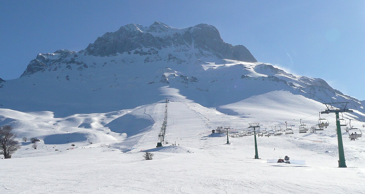
Prati di Tivo is a downhill ski area in Teramo, Italy. Mapped terrain includes easy, intermediate routes. Its mapped lift network extends from approximately 1399 to 2002 metres above sea level.
Data: OpenSkiData / OpenSkiMap, OpenStreetMap contributors (ODbL), Skimap.org, Who's On First, Mapterhorn.
Prati di Tivo - Σταθμός βάσης
ECMWF · Εκτέλεση μοντέλου: Αναμενόμενη επόμενη ενημέρωση:
Ημέρα Ώρα (UTC) Θερμ. (°C) Υγρασία (%) Άνεμος (km/h) Άνεμος (κόμβοι) Άνεμος (Bft) Διεύθυνση Υετός (mm) Νέο χιόνι (cm) Πίεση (hPa) Σημείο παγοποίησης (m) Συνθήκες | Τετάρτη, 04/11 06:00 3.7 84 5 3 1B E — — 1022 2420 Cloudy 62% cloud 09:00 4.7 86 6 3 2B E 0 0 1023 2430 Overcast 99% cloud 12:00 5.5 85 4 2 1B E 0.17 0 1023 2493 Overcast 97% cloud 15:00 4.7 96 5 3 1B E 0.14 0 1024 2414 Overcast 100% cloud 18:00 4 97 4 2 1B E 0.04 0 1025 2371 Overcast 97% cloud 21:00 3.6 94 5 3 1B E 0.00 0 1027 2378 Overcast 92% cloud Πέμπτη, 05/11 00:00 3.5 96 5 3 1B E 0 0 1027 2407 Overcast 99% cloud 03:00 3.4 91 5 3 1B E 0 0 1027 2544 Overcast 98% cloud 06:00 3.5 86 5 3 1B E 0 0 1027 2610 Overcast 99% cloud 09:00 4.9 87 5 3 1B E 0.03 0 1027 2711 Cloudy 64% cloud 12:00 6.3 81 5 3 1B E 0.03 0 1026 2800 Cloudy 54% cloud 15:00 5.5 92 3 2 1B E 0.03 0 1026 2876 Overcast 91% cloud 18:00 4.9 88 2 1 1B NE 0 0 1026 3031 Overcast 96% cloud 21:00 4.8 68 2 1 1B NE 0.03 0 1026 3075 Overcast 93% cloud Παρασκευή, 06/11 00:00 4.7 66 2 1 1B E 0 0 1025 3041 Cloudy 54% cloud 03:00 5.2 58 2 1 1B S 0 0 1023 3071 Partly cloudy 33% cloud 06:00 5.3 66 2 1 1B S 0 0 1023 3048 Overcast 88% cloud 09:00 7.1 61 4 2 1B S 0 0 1023 2980 Overcast 98% cloud 12:00 7.1 78 3 1 1B SE 0.92 0 1021 2922 Overcast 100% cloud 15:00 7.1 88 5 3 1B SE 0.89 0 1021 2901 Overcast 88% cloud 18:00 6.6 88 5 3 1B SE 0.00 0 1020 2923 Overcast 100% cloud 21:00 6.5 89 4 2 1B S 0 0 1020 2859 Overcast 100% cloud Σάββατο, 07/11 00:00 6.2 92 4 2 1B S 0.09 0 1020 2794 Overcast 91% cloud 03:00 6.1 96 5 3 1B SW 1.1 0 1019 2656 Overcast 100% cloud 06:00 5.8 99 4 2 1B SW 0.08 0 1020 2648 Overcast 98% cloud 09:00 6.5 88 4 2 1B SW 0.03 0 1021 2628 Partly cloudy 23% cloud 12:00 8.2 62 3 2 1B W 0.03 0 1019 2641 Partly cloudy 41% cloud 15:00 7.3 78 1 1 0B E 0.19 0 1020 2562 Cloudy 72% cloud 18:00 6.1 98 2 1 1B S 0.12 0 1022 2517 Overcast 100% cloud 21:00 5.9 89 3 2 1B S 0 0 1023 2552 Overcast 99% cloud Κυριακή, 08/11 00:00 5.1 90 4 2 1B SW 0 0 1023 2543 Overcast 97% cloud 03:00 4.9 88 5 3 1B W 0 0 1023 2546 Overcast 100% cloud 06:00 4.9 75 5 3 1B SW 0.00 0 1023 2595 Overcast 100% cloud 09:00 6 74 4 2 1B SW 0 0 1025 2659 Overcast 84% cloud 12:00 7.7 60 8 5 2B SW 0.08 0 1024 2687 Cloudy 69% cloud 15:00 6.9 70 5 3 1B SW 0.28 0 1024 2704 Partly cloudy 41% cloud 18:00 5.4 81 2 1 1B SW 0.19 0 1025 2666 Partly cloudy 32% cloud 21:00 5.1 82 4 2 1B S 0.06 0 1026 2652 Partly cloudy 33% cloud Δευτέρα, 09/11 00:00 4.7 85 5 3 1B SW 0 0 1026 2644 Partly cloudy 25% cloud 03:00 4.5 71 4 2 1B W 0.03 0 1025 2667 Overcast 96% cloud 06:00 4.6 66 4 2 1B W 0 0 1025 2658 Overcast 98% cloud 09:00 6.8 53 5 2 1B SW 0 0 1026 2735 Overcast 99% cloud 12:00 8.7 52 7 4 2B SW 0 0 1024 2851 Partly cloudy 49% cloud 15:00 8 57 9 5 2B W 0 0 1024 2896 Overcast 81% cloud 18:00 7 55 8 4 2B SW 0 0 1024 3019 Cloudy 72% cloud 21:00 7 57 12 6 2B SW 0 0 1024 3066 Cloudy 70% cloud Τρίτη, 10/11 00:00 6.8 83 15 8 3B SW 0 0 1023 3126 Overcast 96% cloud 03:00 7.3 93 14 7 3B SW 0 0 1021 3113 Overcast 99% cloud 06:00 7.6 93 14 8 3B SW 0.09 0 1020 3111 Overcast 100% cloud |
|---|
Forecast notes
Forecast table times: UTC.
Coordinates: 42.4995953°N, 13.5564087°E · Requested elevation: 1446 m. Model terrain: 1233 m. Terrain and 1000/925/850/700 hPa profiles are used for height estimates.
These are altitude estimates, not a simulation of local mountain terrain. Precipitation, cloud and sea-level pressure use horizontal interpolation only.
Precipitation includes rain and snow water equivalent: preceding 3 hours through day 6, then 6 hours (see cell tooltip). Snow (cm) estimates fresh snowfall from precipitation and temperature using the GFS conversion; it is not snow depth on the ground. Freezing (m) uses additional 600/500 hPa temperatures when available and estimates the lowest resolved 0°C crossing above sea level. When all sampled levels are warm, the upper profile limit is shown (see tooltip). < marks an entirely cold sampled profile and its lower height limit. No extrapolation is used.
Source: ECMWF · CC BY 4.0 · Processed by Snow Report.
Prati di Tivo - Άνω σταθμός
ECMWF · Εκτέλεση μοντέλου: Αναμενόμενη επόμενη ενημέρωση:
Ημέρα Ώρα (UTC) Θερμ. (°C) Υγρασία (%) Άνεμος (km/h) Άνεμος (κόμβοι) Άνεμος (Bft) Διεύθυνση Υετός (mm) Νέο χιόνι (cm) Πίεση (hPa) Σημείο παγοποίησης (m) Συνθήκες | Τετάρτη, 04/11 06:00 1.8 67 2 1 1B SE — — 1022 2425 Cloudy 63% cloud 09:00 1.7 73 3 2 1B SE 0 0 1023 2431 Overcast 98% cloud 12:00 2.3 76 3 2 1B S 0.16 0 1023 2489 Overcast 97% cloud 15:00 1.9 84 3 2 1B S 0.15 0 1024 2415 Overcast 100% cloud 18:00 1.6 85 1 1 0B SE 0.05 0 1025 2377 Overcast 96% cloud 21:00 1.4 82 4 2 1B E 0.00 0 1027 2382 Overcast 91% cloud Πέμπτη, 05/11 00:00 1.4 84 3 2 1B NE 0 0 1027 2410 Overcast 99% cloud 03:00 1.7 74 3 2 1B NE 0 0 1027 2543 Overcast 97% cloud 06:00 1.9 69 4 2 1B E 0 0 1027 2609 Overcast 98% cloud 09:00 2.2 75 3 2 1B E 0.03 0 1027 2711 Cloudy 66% cloud 12:00 3.1 73 3 1 1B NE 0.03 0 1026 2800 Cloudy 56% cloud 15:00 3.1 77 2 1 1B NE 0.03 0 1026 2877 Overcast 92% cloud 18:00 3.4 67 2 1 1B NE 0 0 1026 3034 Overcast 97% cloud 21:00 3.8 48 1 1 1B E 0.03 0 1026 3070 Overcast 93% cloud Παρασκευή, 06/11 00:00 4 50 2 1 1B S 0 0 1025 3042 Cloudy 57% cloud 03:00 4.4 47 4 2 1B SW 0 0 1023 3071 Partly cloudy 36% cloud 06:00 4.3 60 4 2 1B S 0 0 1023 3047 Overcast 88% cloud 09:00 4.4 66 8 4 2B S 0 0 1023 2981 Overcast 98% cloud 12:00 4.5 79 10 6 2B SW 0.95 0 1021 2926 Overcast 100% cloud 15:00 4.5 88 5 3 1B SW 1.1 0 1021 2904 Overcast 89% cloud 18:00 4.4 87 4 2 1B S 0.01 0 1020 2923 Overcast 100% cloud 21:00 4.4 85 6 3 1B S 0 0 1020 2861 Overcast 100% cloud Σάββατο, 07/11 00:00 4.1 89 6 3 2B SW 0.09 0 1020 2796 Overcast 90% cloud 03:00 3.4 98 8 5 2B SW 1.0 0 1019 2659 Overcast 100% cloud 06:00 3.2 87 8 4 2B SW 0.10 0 1020 2652 Overcast 98% cloud 09:00 3.3 75 7 4 2B SW 0.04 0 1021 2631 Partly cloudy 27% cloud 12:00 4.1 60 6 3 2B SW 0.03 0 1019 2642 Partly cloudy 46% cloud 15:00 3.6 80 5 3 1B W 0.23 0 1020 2561 Cloudy 74% cloud 18:00 2.9 90 5 2 1B SW 0.12 0 1022 2518 Overcast 99% cloud 21:00 3.2 79 5 3 1B SW 0 0 1023 2553 Overcast 98% cloud Κυριακή, 08/11 00:00 3.1 77 8 4 2B SW 0 0 1023 2543 Overcast 96% cloud 03:00 3 70 10 5 2B SW 0 0 1023 2550 Overcast 100% cloud 06:00 3 56 11 6 2B SW 0.00 0 1023 2598 Overcast 100% cloud 09:00 3 60 12 6 2B SW 0 0 1025 2661 Overcast 82% cloud 12:00 3.9 53 16 8 3B W 0.09 0 1024 2687 Cloudy 69% cloud 15:00 3.7 62 13 7 3B W 0.32 0 1024 2702 Partly cloudy 45% cloud 18:00 3.1 69 9 5 2B W 0.22 0 1025 2667 Partly cloudy 37% cloud 21:00 2.9 73 9 5 2B SW 0.06 0 1026 2655 Partly cloudy 37% cloud Δευτέρα, 09/11 00:00 2.6 76 11 6 2B W 0 0 1026 2642 Partly cloudy 29% cloud 03:00 2.8 61 10 5 2B W 0.03 0 1025 2669 Overcast 96% cloud 06:00 3.2 58 11 6 2B W 0 0 1025 2662 Overcast 99% cloud 09:00 3.8 51 12 6 2B W 0 0 1026 2738 Overcast 99% cloud 12:00 4.8 56 15 8 3B W 0 0 1024 2851 Partly cloudy 49% cloud 15:00 5 56 17 9 3B W 0 0 1024 2897 Overcast 82% cloud 18:00 5.2 47 14 8 3B W 0 0 1024 3023 Cloudy 70% cloud 21:00 5.5 48 19 10 3B W 0 0 1024 3071 Cloudy 71% cloud Τρίτη, 10/11 00:00 5.2 74 23 12 4B W 0 0 1023 3126 Overcast 95% cloud 03:00 5.7 79 22 12 4B W 0 0 1021 3113 Overcast 99% cloud 06:00 6.1 82 20 11 4B W 0.08 0 1020 3111 Overcast 100% cloud |
|---|
Forecast notes
Forecast table times: UTC.
Coordinates: 42.4873461°N, 13.5681103°E · Requested elevation: 2002 m. Model terrain: 1204 m. Terrain and 1000/925/850/700 hPa profiles are used for height estimates.
These are altitude estimates, not a simulation of local mountain terrain. Precipitation, cloud and sea-level pressure use horizontal interpolation only.
Precipitation includes rain and snow water equivalent: preceding 3 hours through day 6, then 6 hours (see cell tooltip). Snow (cm) estimates fresh snowfall from precipitation and temperature using the GFS conversion; it is not snow depth on the ground. Freezing (m) uses additional 600/500 hPa temperatures when available and estimates the lowest resolved 0°C crossing above sea level. When all sampled levels are warm, the upper profile limit is shown (see tooltip). < marks an entirely cold sampled profile and its lower height limit. No extrapolation is used.