Worldwide Ski Resort Forecasts

Colour guide Temperature · Wind · Rain · Snow
Each colour starts at the value shown. Wind colours match across all three units. Dry cells stay neutral. Colours describe the displayed values, not official weather warnings.
Powder Ridge Ski Area - Low lift station
ECMWF · Model run: Next update expected:
Day Time (UTC) Temp. (°C) Humidity (%) Wind (km/h) Wind (knots) Wind (Bft) Direction Precip. (mm) Snow (cm) Pressure (hPa) Freezing (m) Conditions | Wednesday, 04/11 06:00 12.6 85 14 8 3B SW — — 1022 3168 Partly cloudy 22% cloud  09:00 12.2 85 12 7 2B SW 0 0 1022 3162 Partly cloudy 27% cloud 12:00 11.5 87 12 7 2B SW 0 0 1022 3164 Clear 1% cloud  15:00 16.9 69 12 7 2B SW 0 0 1021 3159 Clear 0% cloud 18:00 19.4 55 19 10 3B SW 0 0 1019 3147 Clear 0% cloud 21:00 18.1 60 18 10 3B S 0 0 1018 3144 Clear 0% cloud Thursday, 05/11 00:00 15.1 79 17 9 3B SW 0 0 1018 3142 Clear 0% cloud 03:00 14.6 96 17 9 3B SW 0 0 1018 3134 Clear 13% cloud 06:00 15.7 99 17 9 3B SW 0 0 1017 3121 Overcast 100% cloud  09:00 16.2 99 18 10 3B SW 0 0 1016 3110 Overcast 100% cloud 12:00 16.2 99 16 9 3B S 0 0 1015 3109 Overcast 100% cloud 15:00 18.6 86 20 11 4B S 0 0 1015 3107 Overcast 94% cloud 18:00 19 85 21 11 4B S 0.96 0 1013 3090 Overcast 100% cloud 21:00 19 81 18 10 3B S 0.03 0 1012 3088 Overcast 83% cloud Friday, 06/11 00:00 18 90 20 11 3B S 0.12 0 1012 3094 Overcast 95% cloud 03:00 16.7 97 19 10 3B S 1.1 0 1012 3092 Cloudy 66% cloud  06:00 16.7 97 13 7 3B S 1.4 0 1012 3085 Overcast 100% cloud 09:00 16.3 99 10 5 2B S 0.30 0 1012 3081 Overcast 84% cloud 12:00 16.2 99 4 2 1B SW 0.00 0 1012 3086 Overcast 82% cloud 15:00 19 89 4 2 1B SW 0.12 0 1013 3086 Overcast 100% cloud 18:00 20.7 79 8 4 2B S 0.24 0 1011 3073 Overcast 100% cloud 21:00 17.9 96 6 3 2B S 1.3 0 1011 3066 Overcast 100% cloud Saturday, 07/11 00:00 16.2 99 6 3 1B S 0.18 0 1011 3064 Overcast 100% cloud 03:00 16.2 99 2 1 1B N 0.01 0 1010 3052 Overcast 100% cloud 06:00 15.3 98 10 5 2B N 0.25 0 1009 3033 Overcast 100% cloud 09:00 13.3 97 11 6 2B N 0.30 0 1009 3015 Overcast 100% cloud 12:00 12.7 97 13 7 3B N 0.01 0 1009 3021 Overcast 100% cloud 15:00 14.4 87 13 7 3B N 0.01 0 1009 2918 Overcast 100% cloud 18:00 15.1 81 9 5 2B N 0.00 0 1008 2820 Overcast 100% cloud 21:00 13.8 86 6 3 2B NE 0.11 0 1007 2539 Cloudy 77% cloud Sunday, 08/11 00:00 12.3 97 2 1 1B NE 5.3 0 1007 2419 Overcast 84% cloud 03:00 11.1 99 16 8 3B W 1.2 0 1006 2088 Overcast 97% cloud 06:00 8.9 96 18 10 3B NW 1.8 0 1005 1819 Overcast 100% cloud 09:00 8.7 97 17 9 3B NW 1.2 0 1006 1716 Overcast 97% cloud 12:00 7.8 94 18 10 3B NW 1.4 0 1008 1834 Overcast 100% cloud 15:00 11 66 19 10 3B NW 0.13 0 1009 1966 Partly cloudy 29% cloud 18:00 13.6 55 22 12 4B W 0 0 1007 1817 Clear 16% cloud 21:00 11.9 58 17 9 3B W 0 0 1007 1938 Clear 2% cloud Monday, 09/11 00:00 8.3 71 11 6 2B SW 0 0 1007 2048 Clear 0% cloud 03:00 7.2 74 12 7 2B SW 0 0 1007 1808 Partly cloudy 28% cloud 06:00 7.5 65 12 7 3B SW 0 0 1006 1582 Clear 3% cloud 09:00 6.6 70 13 7 3B SW 0 0 1005 1580 Clear 8% cloud 12:00 7.6 79 18 10 3B W 0.00 0 1006 1356 Partly cloudy 26% cloud 15:00 10.5 61 23 13 4B NW 0.00 0 1007 1259 Partly cloudy 23% cloud 18:00 10.9 56 24 13 4B NW 0 0 1008 1253 Overcast 98% cloud 21:00 10.2 58 20 11 3B NW 0 0 1010 1218 Partly cloudy 42% cloud Tuesday, 10/11 00:00 7.5 65 15 8 3B NW 0 0 1013 1392 Clear 11% cloud 03:00 5.9 72 13 7 3B NW 0 0 1014 2028 Clear 18% cloud 06:00 4.8 78 6 3 2B W 0 0 1015 2441 Cloudy 53% cloud |
|---|
Forecast notes
Forecast table times: UTC.
Coordinates: 41.5028611°N, -72.7372756°E · Requested elevation: 116 m. Model terrain: 89 m. Terrain and 1000/925/850/700 hPa profiles are used for height estimates.
These are altitude estimates, not a simulation of local mountain terrain. Precipitation, cloud and sea-level pressure use horizontal interpolation only.
Precipitation includes rain and snow water equivalent: preceding 3 hours through day 6, then 6 hours (see cell tooltip). Snow (cm) estimates fresh snowfall from precipitation and temperature using the GFS conversion; it is not snow depth on the ground. Freezing (m) uses additional 600/500 hPa temperatures when available and estimates the lowest resolved 0°C crossing above sea level. When all sampled levels are warm, the upper profile limit is shown (see tooltip). < marks an entirely cold sampled profile and its lower height limit. No extrapolation is used.
Source: ECMWF · CC BY 4.0 · Processed by Snow Report.
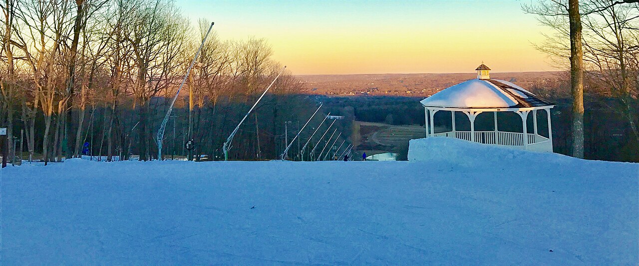
Powder Ridge Ski Area is a downhill ski area in Connecticut, United States. Mapped terrain includes easy, intermediate, advanced routes. Its mapped lift network extends from approximately 116 to 246 metres above sea level.
Data: OpenSkiData / OpenSkiMap, OpenStreetMap contributors (ODbL), Skimap.org, Who's On First, Mapterhorn.
Powder Ridge Ski Area - Base lift station
ECMWF · Model run: Next update expected:
Day Time (UTC) Temp. (°C) Humidity (%) Wind (km/h) Wind (knots) Wind (Bft) Direction Precip. (mm) Snow (cm) Pressure (hPa) Freezing (m) Conditions | Wednesday, 04/11 06:00 12.7 85 14 8 3B SW — — 1022 3168 Partly cloudy 22% cloud 09:00 12.2 85 12 7 3B SW 0 0 1022 3162 Partly cloudy 26% cloud 12:00 11.5 87 12 7 3B SW 0 0 1022 3164 Clear 1% cloud 15:00 16.8 69 12 7 3B SW 0 0 1021 3159 Clear 0% cloud 18:00 19.3 55 19 10 3B SW 0 0 1019 3147 Clear 0% cloud 21:00 18.1 60 19 10 3B S 0 0 1018 3144 Clear 0% cloud Thursday, 05/11 00:00 15.1 78 17 9 3B SW 0 0 1018 3142 Clear 0% cloud 03:00 14.7 96 18 10 3B SW 0 0 1018 3134 Clear 13% cloud 06:00 15.7 99 17 9 3B SW 0 0 1017 3121 Overcast 100% cloud 09:00 16.2 99 19 10 3B SW 0 0 1016 3110 Overcast 100% cloud 12:00 16.2 99 16 9 3B S 0 0 1015 3109 Overcast 100% cloud 15:00 18.6 86 21 11 4B S 0 0 1015 3107 Overcast 94% cloud 18:00 19 85 21 12 4B S 0.97 0 1013 3090 Overcast 100% cloud 21:00 19 81 18 10 3B S 0.03 0 1012 3088 Overcast 83% cloud Friday, 06/11 00:00 18 90 20 11 4B S 0.12 0 1012 3094 Overcast 95% cloud 03:00 16.7 97 19 10 3B S 1.1 0 1012 3092 Cloudy 66% cloud 06:00 16.7 97 13 7 3B S 1.4 0 1012 3085 Overcast 100% cloud 09:00 16.3 99 10 5 2B S 0.30 0 1012 3081 Overcast 84% cloud 12:00 16.2 99 4 2 1B SW 0.00 0 1012 3086 Overcast 82% cloud 15:00 19 89 4 2 1B SW 0.12 0 1013 3086 Overcast 100% cloud 18:00 20.7 79 8 4 2B S 0.24 0 1011 3073 Overcast 100% cloud 21:00 17.9 96 6 3 2B S 1.3 0 1011 3066 Overcast 100% cloud Saturday, 07/11 00:00 16.2 99 6 3 1B S 0.18 0 1011 3064 Overcast 100% cloud 03:00 16.2 99 3 1 1B N 0.00 0 1010 3052 Overcast 100% cloud 06:00 15.3 98 10 5 2B N 0.26 0 1009 3033 Overcast 100% cloud 09:00 13.3 97 11 6 2B N 0.30 0 1009 3015 Overcast 100% cloud 12:00 12.7 97 13 7 3B N 0.01 0 1009 3021 Overcast 100% cloud 15:00 14.4 87 13 7 3B N 0.01 0 1009 2918 Overcast 100% cloud 18:00 15.1 82 9 5 2B N 0.00 0 1008 2821 Overcast 100% cloud 21:00 13.8 86 6 3 2B NE 0.12 0 1007 2539 Cloudy 76% cloud Sunday, 08/11 00:00 12.3 97 2 1 1B NE 5.3 0 1007 2419 Overcast 84% cloud 03:00 11.1 99 16 9 3B W 1.2 0 1006 2088 Overcast 97% cloud 06:00 8.8 96 18 10 3B NW 1.8 0 1005 1818 Overcast 100% cloud 09:00 8.7 97 17 9 3B NW 1.2 0 1006 1716 Overcast 97% cloud 12:00 7.8 94 18 10 3B NW 1.4 0 1008 1833 Overcast 100% cloud 15:00 10.9 66 19 10 3B NW 0.13 0 1009 1966 Partly cloudy 29% cloud 18:00 13.6 55 22 12 4B W 0 0 1007 1818 Clear 16% cloud 21:00 11.9 58 18 9 3B W 0 0 1007 1939 Clear 2% cloud Monday, 09/11 00:00 8.3 71 11 6 2B SW 0 0 1007 2049 Clear 0% cloud 03:00 7.2 74 12 7 3B SW 0 0 1007 1808 Partly cloudy 28% cloud 06:00 7.5 65 12 7 3B SW 0 0 1006 1582 Clear 3% cloud 09:00 6.6 70 13 7 3B SW 0 0 1005 1580 Clear 8% cloud 12:00 7.6 79 18 10 3B W 0.00 0 1006 1356 Partly cloudy 26% cloud 15:00 10.5 61 23 13 4B NW 0.00 0 1007 1259 Partly cloudy 23% cloud 18:00 10.9 57 24 13 4B NW 0 0 1008 1253 Overcast 98% cloud 21:00 10.2 58 20 11 4B NW 0 0 1010 1218 Partly cloudy 42% cloud Tuesday, 10/11 00:00 7.5 65 16 8 3B NW 0 0 1013 1391 Clear 11% cloud 03:00 5.9 72 13 7 3B NW 0 0 1014 2027 Clear 18% cloud 06:00 4.7 78 6 3 2B W 0 0 1015 2441 Cloudy 53% cloud |
|---|
Forecast notes
Forecast table times: UTC.
Coordinates: 41.5010464°N, -72.7370051°E · Requested elevation: 118 m. Model terrain: 90 m. Terrain and 1000/925/850/700 hPa profiles are used for height estimates.
These are altitude estimates, not a simulation of local mountain terrain. Precipitation, cloud and sea-level pressure use horizontal interpolation only.
Precipitation includes rain and snow water equivalent: preceding 3 hours through day 6, then 6 hours (see cell tooltip). Snow (cm) estimates fresh snowfall from precipitation and temperature using the GFS conversion; it is not snow depth on the ground. Freezing (m) uses additional 600/500 hPa temperatures when available and estimates the lowest resolved 0°C crossing above sea level. When all sampled levels are warm, the upper profile limit is shown (see tooltip). < marks an entirely cold sampled profile and its lower height limit. No extrapolation is used.
Source: ECMWF · CC BY 4.0 · Processed by Snow Report.
Powder Ridge Ski Area - Top lift station
ECMWF · Model run: Next update expected:
Day Time (UTC) Temp. (°C) Humidity (%) Wind (km/h) Wind (knots) Wind (Bft) Direction Precip. (mm) Snow (cm) Pressure (hPa) Freezing (m) Conditions | Wednesday, 04/11 06:00 14.4 73 23 12 4B SW — — 1022 3168 Partly cloudy 21% cloud 09:00 13.6 73 22 12 4B SW 0 0 1022 3162 Partly cloudy 25% cloud 12:00 12.8 77 20 11 4B SW 0 0 1022 3164 Clear 0% cloud 15:00 15.4 71 17 9 3B SW 0 0 1021 3159 Clear 0% cloud 18:00 17.9 57 24 13 4B SW 0 0 1019 3147 Clear 0% cloud 21:00 17.6 59 25 14 4B SW 0 0 1018 3144 Clear 0% cloud Thursday, 05/11 00:00 15.8 71 24 13 4B SW 0 0 1018 3141 Clear 0% cloud 03:00 15.1 89 24 13 4B SW 0 0 1018 3134 Clear 13% cloud 06:00 15.4 96 25 14 4B SW 0 0 1017 3121 Overcast 100% cloud 09:00 15.7 98 26 14 4B SW 0 0 1016 3110 Overcast 100% cloud 12:00 15.8 99 23 12 4B SW 0 0 1015 3109 Overcast 100% cloud 15:00 17.9 87 30 16 5B SW 0 0 1015 3107 Overcast 94% cloud 18:00 18.1 86 30 16 5B SW 0.97 0 1013 3090 Overcast 100% cloud 21:00 18.3 83 26 14 4B SW 0.01 0 1012 3088 Overcast 83% cloud Friday, 06/11 00:00 17.7 91 29 15 4B SW 0.12 0 1012 3094 Overcast 95% cloud 03:00 16.5 97 28 15 4B SW 1.1 0 1012 3092 Cloudy 65% cloud 06:00 16.5 97 18 10 3B SW 1.3 0 1012 3085 Overcast 100% cloud 09:00 16 98 12 7 3B SW 0.26 0 1012 3081 Overcast 83% cloud 12:00 16 97 5 3 1B SW 0.00 0 1012 3086 Overcast 82% cloud 15:00 18.1 90 4 2 1B SW 0.12 0 1013 3086 Overcast 100% cloud 18:00 19.5 82 9 5 2B S 0.24 0 1011 3073 Overcast 100% cloud 21:00 17.5 91 7 4 2B S 1.2 0 1011 3066 Overcast 100% cloud Saturday, 07/11 00:00 16 95 6 3 2B SW 0.14 0 1011 3064 Overcast 100% cloud 03:00 15.9 96 3 2 1B N 0.00 0 1010 3052 Overcast 100% cloud 06:00 15 97 10 5 2B N 0.25 0 1009 3033 Overcast 100% cloud 09:00 13.2 97 12 6 2B N 0.26 0 1009 3014 Overcast 100% cloud 12:00 12.4 98 14 7 3B N 0.00 0 1009 3021 Overcast 100% cloud 15:00 13.5 90 14 8 3B NE 0.00 0 1009 2916 Overcast 100% cloud 18:00 14 85 10 5 2B N 0.00 0 1008 2818 Overcast 100% cloud 21:00 12.8 89 6 3 2B NE 0.12 0 1007 2538 Cloudy 75% cloud Sunday, 08/11 00:00 11.5 98 1 0 0B SW 5.4 0 1007 2419 Overcast 83% cloud 03:00 10.3 99 17 9 3B NW 1.1 0 1006 2086 Overcast 97% cloud 06:00 8.1 96 23 13 4B NW 1.7 0 1005 1815 Overcast 100% cloud 09:00 8.1 95 23 12 4B NW 1.1 0 1006 1715 Overcast 97% cloud 12:00 7 94 28 15 4B NW 1.5 0 1008 1837 Overcast 100% cloud 15:00 9.5 71 25 14 4B NW 0.12 0 1009 1967 Partly cloudy 28% cloud 18:00 12.1 59 26 14 4B W 0 0 1007 1821 Clear 14% cloud 21:00 10.7 61 23 12 4B W 0 0 1007 1946 Clear 2% cloud Monday, 09/11 00:00 8.1 67 19 10 3B W 0 0 1007 2049 Clear 0% cloud 03:00 7.3 70 19 10 3B W 0 0 1007 1808 Partly cloudy 28% cloud 06:00 7.3 63 19 10 3B W 0 0 1006 1583 Clear 2% cloud 09:00 6.4 71 22 12 4B W 0 0 1005 1583 Clear 8% cloud 12:00 6.8 80 26 14 4B W 0.00 0 1006 1357 Partly cloudy 25% cloud 15:00 9 65 28 15 4B NW 0.00 0 1007 1259 Partly cloudy 22% cloud 18:00 9.5 60 29 16 5B NW 0 0 1008 1252 Overcast 98% cloud 21:00 9 60 26 14 4B NW 0 0 1010 1218 Partly cloudy 42% cloud Tuesday, 10/11 00:00 6.5 67 24 13 4B NW 0 0 1013 1389 Clear 11% cloud 03:00 5 72 22 12 4B NW 0 0 1014 2031 Clear 19% cloud 06:00 4.2 79 14 7 3B NW 0 0 1015 2447 Cloudy 53% cloud |
|---|
Forecast notes
Forecast table times: UTC.
Coordinates: 41.5002305°N, -72.7461177°E · Requested elevation: 246 m. Model terrain: 88 m. Terrain and 1000/925/850/700 hPa profiles are used for height estimates.
These are altitude estimates, not a simulation of local mountain terrain. Precipitation, cloud and sea-level pressure use horizontal interpolation only.
Precipitation includes rain and snow water equivalent: preceding 3 hours through day 6, then 6 hours (see cell tooltip). Snow (cm) estimates fresh snowfall from precipitation and temperature using the GFS conversion; it is not snow depth on the ground. Freezing (m) uses additional 600/500 hPa temperatures when available and estimates the lowest resolved 0°C crossing above sea level. When all sampled levels are warm, the upper profile limit is shown (see tooltip). < marks an entirely cold sampled profile and its lower height limit. No extrapolation is used.