Προγνώσεις για χιονοδρομικά σε όλο τον κόσμο

Περισσότερα
Χρωματική κλίμακα Θερμοκρασία · Άνεμος · Βροχή · Χιόνι
Κάθε χρώμα ξεκινά από την τιμή που αναγράφεται. Τα χρώματα ανέμου αντιστοιχούν και στις τρεις μονάδες. Οι τιμές χωρίς υετό παραμένουν ουδέτερες. Τα χρώματα περιγράφουν τις τιμές και δεν αποτελούν επίσημες προειδοποιήσεις.
Osorakan Snow Park - Χαμηλός σταθμός
ECMWF · Εκτέλεση μοντέλου: Αναμενόμενη επόμενη ενημέρωση:
Ημέρα Ώρα (UTC) Θερμ. (°C) Υγρασία (%) Άνεμος (km/h) Άνεμος (κόμβοι) Άνεμος (Bft) Διεύθυνση Υετός (mm) Νέο χιόνι (cm) Πίεση (hPa) Σημείο παγοποίησης (m) Συνθήκες | Τετάρτη, 04/11 06:00 11.4 60 7 4 2B E — — 1023 3134 Overcast 100% cloud  09:00 11.2 59 7 4 2B SE 0.41 0 1024 3089 Overcast 100% cloud 12:00 10.2 64 9 5 2B SE 1.3 0 1023 3076 Overcast 100% cloud 15:00 11.7 56 8 4 2B S 0.44 0 1021 2989 Overcast 100% cloud 18:00 12.8 51 9 5 2B S 0.02 0 1018 3106 Overcast 97% cloud 21:00 13.3 53 11 6 2B S 0 0 1016 3096 Clear 16% cloud  Πέμπτη, 05/11 00:00 13.3 58 20 11 3B S 0 0 1015 3089 Overcast 94% cloud 03:00 13.1 65 35 19 5B S 2.8 0 1012 3069 Overcast 99% cloud 06:00 13.9 89 40 22 6B SW 3.9 0 1008 3049 Overcast 99% cloud 09:00 14.2 95 37 20 5B SW 2.9 0 1008 3043 Overcast 95% cloud 12:00 12.8 95 48 26 6B NW 1.3 0 1009 3039 Overcast 98% cloud 15:00 11.3 94 41 22 6B NW 2.1 0 1011 3042 Overcast 90% cloud 18:00 10.3 93 43 23 6B NW 1.7 0 1013 3048 Overcast 88% cloud 21:00 9.4 77 45 24 6B NW 0.18 0 1015 3056 Clear 10% cloud Παρασκευή, 06/11 00:00 9.9 82 41 22 6B NW 0.03 0 1017 3071 Cloudy 51% cloud  03:00 9.6 65 42 23 6B NW 0.40 0 1017 3065 Clear 10% cloud 06:00 7.8 62 38 21 5B NW 0 0 1018 3060 Clear 7% cloud 09:00 6.7 65 39 21 5B NW 0 0 1021 2675 Partly cloudy 30% cloud  12:00 6.3 65 39 21 6B NW 0 0 1023 1800 Cloudy 52% cloud 15:00 5.1 73 42 22 6B NW 0 0 1024 1464 Cloudy 52% cloud 18:00 3.8 81 42 22 6B NW 0.03 0 1025 1356 Overcast 85% cloud 21:00 3.3 78 39 21 5B NW 0.03 0 1027 1294 Cloudy 78% cloud Σάββατο, 07/11 00:00 3.8 68 35 19 5B NW 0 0 1029 1335 Partly cloudy 35% cloud 03:00 4.9 61 32 17 5B NW 0 0 1030 1382 Partly cloudy 37% cloud 06:00 4.7 67 27 14 4B N 0 0 1029 1462 Partly cloudy 20% cloud 09:00 3.9 78 24 13 4B N 0 0 1032 1520 Clear 19% cloud 12:00 4.5 71 25 13 4B N 0 0 1032 3149 Partly cloudy 22% cloud 15:00 5.1 65 19 10 3B N 0 0 1032 3155 Partly cloudy 49% cloud 18:00 4.8 70 17 9 3B NE 0 0 1032 3155 Cloudy 73% cloud 21:00 4.5 74 19 10 3B NE 0 0 1032 3160 Overcast 99% cloud Κυριακή, 08/11 00:00 5.2 69 20 11 4B NE 0 0 1034 3173 Overcast 100% cloud 03:00 7.1 60 15 8 3B NE 0 0 1031 3093 Overcast 96% cloud 06:00 8 61 11 6 2B NE 0 0 1030 2720 Overcast 100% cloud 09:00 7.5 65 13 7 3B E 0 0 1030 2802 Overcast 98% cloud 12:00 6.9 69 9 5 2B SE 0 0 1031 2700 Overcast 99% cloud 15:00 6.9 66 1 0 0B SE 0 0 1030 2396 Overcast 100% cloud 18:00 7.2 68 10 5 2B N 0.02 0 1029 2539 Overcast 100% cloud 21:00 7.2 69 15 8 3B N 0 0 1028 2647 Cloudy 72% cloud Δευτέρα, 09/11 00:00 7.5 77 16 9 3B N 0 0 1028 2649 Partly cloudy 21% cloud 03:00 8.7 80 16 9 3B NW 0.23 0 1026 2467 Overcast 84% cloud 06:00 8.1 84 24 13 4B NW 0.48 0 1026 2321 Overcast 88% cloud 09:00 7.1 91 30 16 5B N 0.17 0 1026 2298 Partly cloudy 49% cloud 12:00 6.5 94 34 18 5B N 0.26 0 1027 2172 Overcast 83% cloud 15:00 6.3 80 31 17 5B N 0.03 0 1026 2076 Clear 19% cloud 18:00 6.2 82 25 13 4B N 0.02 0 1026 2029 Clear 15% cloud 21:00 5.4 89 30 16 5B NE 0 0 1027 1949 Partly cloudy 40% cloud Τρίτη, 10/11 00:00 5.6 86 28 15 4B NE 0.02 0 1028 1972 Cloudy 50% cloud 03:00 7.2 72 19 10 3B NE 0.06 0 1027 2047 Overcast 87% cloud 06:00 7.5 69 16 9 3B NE 0.02 0 1026 2177 Cloudy 57% cloud |
|---|
Forecast notes
Forecast table times: UTC.
Coordinates: 34.5958909°N, 132.1463527°E · Requested elevation: 882 m. Model terrain: 588 m. Terrain and 1000/925/850/700 hPa profiles are used for height estimates.
These are altitude estimates, not a simulation of local mountain terrain. Precipitation, cloud and sea-level pressure use horizontal interpolation only.
Precipitation includes rain and snow water equivalent: preceding 3 hours through day 6, then 6 hours (see cell tooltip). Snow (cm) estimates fresh snowfall from precipitation and temperature using the GFS conversion; it is not snow depth on the ground. Freezing (m) uses additional 600/500 hPa temperatures when available and estimates the lowest resolved 0°C crossing above sea level. When all sampled levels are warm, the upper profile limit is shown (see tooltip). < marks an entirely cold sampled profile and its lower height limit. No extrapolation is used.
Source: ECMWF · CC BY 4.0 · Processed by Snow Report.
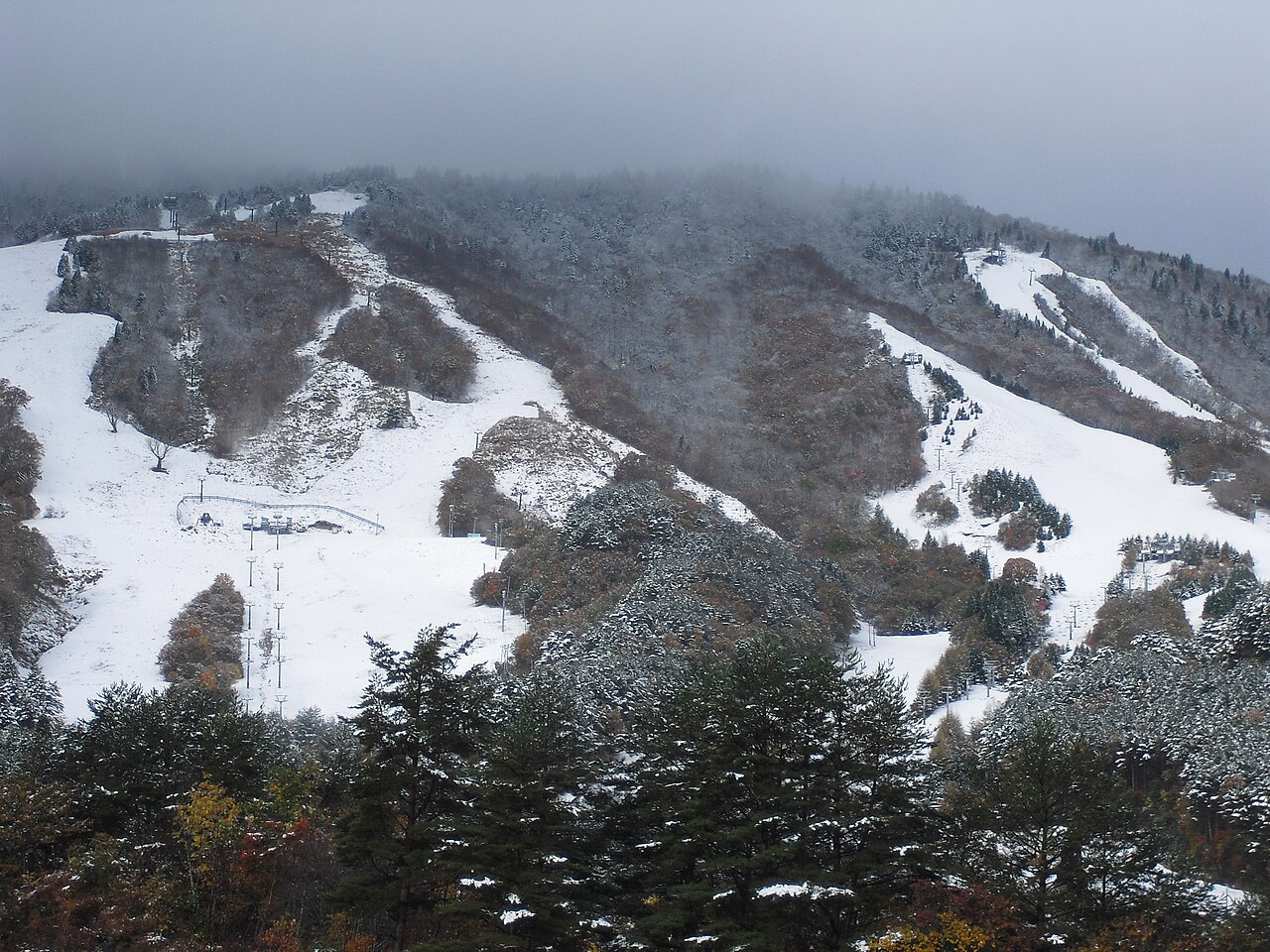
Osorakan Snow Park is a downhill ski area in Hiroshima Prefecture, Japan. Mapped terrain includes beginner, easy, intermediate, advanced routes. Its mapped lift network extends from approximately 882 to 1274 metres above sea level.
Data: OpenSkiData / OpenSkiMap, OpenStreetMap contributors (ODbL), Skimap.org, Who's On First, Mapterhorn.
Osorakan Snow Park - Σταθμός βάσης
ECMWF · Εκτέλεση μοντέλου: Αναμενόμενη επόμενη ενημέρωση:
Ημέρα Ώρα (UTC) Θερμ. (°C) Υγρασία (%) Άνεμος (km/h) Άνεμος (κόμβοι) Άνεμος (Bft) Διεύθυνση Υετός (mm) Νέο χιόνι (cm) Πίεση (hPa) Σημείο παγοποίησης (m) Συνθήκες | Τετάρτη, 04/11 06:00 11.4 60 7 4 2B E — — 1023 3134 Overcast 100% cloud 09:00 11.2 59 7 4 2B SE 0.41 0 1024 3089 Overcast 100% cloud 12:00 10.2 64 9 5 2B SE 1.3 0 1023 3076 Overcast 100% cloud 15:00 11.7 56 8 4 2B S 0.44 0 1021 2989 Overcast 100% cloud 18:00 12.8 51 9 5 2B S 0.02 0 1018 3106 Overcast 97% cloud 21:00 13.3 53 11 6 2B S 0 0 1016 3096 Clear 16% cloud Πέμπτη, 05/11 00:00 13.3 58 20 11 4B S 0 0 1015 3089 Overcast 94% cloud 03:00 13 65 35 19 5B S 2.8 0 1012 3069 Overcast 99% cloud 06:00 13.9 89 40 22 6B SW 3.9 0 1008 3049 Overcast 99% cloud 09:00 14.2 95 37 20 5B SW 2.9 0 1008 3043 Overcast 95% cloud 12:00 12.8 95 48 26 6B NW 1.3 0 1009 3039 Overcast 98% cloud 15:00 11.2 94 41 22 6B NW 2.1 0 1011 3042 Overcast 90% cloud 18:00 10.3 93 44 24 6B NW 1.7 0 1013 3048 Overcast 88% cloud 21:00 9.4 77 45 24 6B NW 0.18 0 1015 3056 Clear 10% cloud Παρασκευή, 06/11 00:00 9.9 82 41 22 6B NW 0.03 0 1017 3071 Cloudy 51% cloud 03:00 9.5 65 42 23 6B NW 0.40 0 1017 3065 Clear 10% cloud 06:00 7.7 62 39 21 5B NW 0 0 1018 3060 Clear 7% cloud 09:00 6.6 65 39 21 5B NW 0 0 1021 2676 Partly cloudy 30% cloud 12:00 6.3 65 39 21 6B NW 0 0 1023 1799 Cloudy 52% cloud 15:00 5 73 42 23 6B NW 0 0 1024 1464 Cloudy 53% cloud 18:00 3.8 81 42 22 6B NW 0.03 0 1025 1355 Overcast 85% cloud 21:00 3.3 78 39 21 5B NW 0.03 0 1027 1294 Cloudy 77% cloud Σάββατο, 07/11 00:00 3.8 68 35 19 5B NW 0 0 1029 1336 Partly cloudy 36% cloud 03:00 4.8 61 32 17 5B NW 0 0 1030 1382 Partly cloudy 37% cloud 06:00 4.7 67 27 14 4B N 0 0 1029 1462 Clear 20% cloud 09:00 3.9 78 24 13 4B N 0 0 1032 1521 Clear 19% cloud 12:00 4.5 71 25 14 4B N 0 0 1032 3149 Partly cloudy 22% cloud 15:00 5.1 65 20 11 3B N 0 0 1032 3155 Partly cloudy 49% cloud 18:00 4.8 70 17 9 3B NE 0 0 1032 3155 Cloudy 73% cloud 21:00 4.5 74 19 10 3B NE 0 0 1032 3160 Overcast 99% cloud Κυριακή, 08/11 00:00 5.2 69 20 11 4B NE 0 0 1034 3173 Overcast 100% cloud 03:00 7 60 15 8 3B NE 0 0 1031 3094 Overcast 96% cloud 06:00 8 61 11 6 2B NE 0 0 1030 2721 Overcast 100% cloud 09:00 7.5 65 13 7 3B E 0 0 1030 2803 Overcast 98% cloud 12:00 6.9 69 9 5 2B SE 0 0 1031 2701 Overcast 99% cloud 15:00 6.9 66 0 0 0B SE 0 0 1030 2396 Overcast 100% cloud 18:00 7.2 68 10 5 2B N 0.02 0 1029 2540 Overcast 100% cloud 21:00 7.2 69 15 8 3B N 0 0 1028 2648 Cloudy 72% cloud Δευτέρα, 09/11 00:00 7.5 77 16 9 3B N 0 0 1028 2649 Partly cloudy 21% cloud 03:00 8.6 80 16 9 3B NW 0.23 0 1026 2468 Overcast 84% cloud 06:00 8.1 85 24 13 4B NW 0.48 0 1026 2321 Overcast 88% cloud 09:00 7.1 91 30 16 5B N 0.17 0 1026 2299 Partly cloudy 49% cloud 12:00 6.5 94 34 18 5B N 0.26 0 1027 2173 Overcast 83% cloud 15:00 6.3 79 31 17 5B N 0.03 0 1026 2076 Clear 19% cloud 18:00 6.2 82 25 13 4B N 0.02 0 1026 2030 Clear 15% cloud 21:00 5.3 89 30 16 5B NE 0 0 1027 1950 Partly cloudy 40% cloud Τρίτη, 10/11 00:00 5.6 86 27 15 4B NE 0.02 0 1028 1973 Cloudy 50% cloud 03:00 7.1 72 19 10 3B NE 0.06 0 1027 2049 Overcast 87% cloud 06:00 7.4 69 16 9 3B NE 0.02 0 1026 2179 Cloudy 56% cloud |
|---|
Forecast notes
Forecast table times: UTC.
Coordinates: 34.594836°N, 132.1448413°E · Requested elevation: 887 m. Model terrain: 588 m. Terrain and 1000/925/850/700 hPa profiles are used for height estimates.
These are altitude estimates, not a simulation of local mountain terrain. Precipitation, cloud and sea-level pressure use horizontal interpolation only.
Precipitation includes rain and snow water equivalent: preceding 3 hours through day 6, then 6 hours (see cell tooltip). Snow (cm) estimates fresh snowfall from precipitation and temperature using the GFS conversion; it is not snow depth on the ground. Freezing (m) uses additional 600/500 hPa temperatures when available and estimates the lowest resolved 0°C crossing above sea level. When all sampled levels are warm, the upper profile limit is shown (see tooltip). < marks an entirely cold sampled profile and its lower height limit. No extrapolation is used.
Source: ECMWF · CC BY 4.0 · Processed by Snow Report.
Osorakan Snow Park - Άνω σταθμός
ECMWF · Εκτέλεση μοντέλου: Αναμενόμενη επόμενη ενημέρωση:
Ημέρα Ώρα (UTC) Θερμ. (°C) Υγρασία (%) Άνεμος (km/h) Άνεμος (κόμβοι) Άνεμος (Bft) Διεύθυνση Υετός (mm) Νέο χιόνι (cm) Πίεση (hPa) Σημείο παγοποίησης (m) Συνθήκες | Τετάρτη, 04/11 06:00 9 59 6 3 2B S — — 1023 3134 Overcast 100% cloud 09:00 9.3 52 6 3 2B W 0.43 0 1024 3084 Overcast 100% cloud 12:00 9.3 60 15 8 3B SW 1.2 0 1023 3076 Overcast 100% cloud 15:00 10.3 57 17 9 3B SW 0.42 0 1021 2990 Overcast 100% cloud 18:00 10.9 57 16 9 3B SW 0.02 0 1018 3106 Overcast 97% cloud 21:00 11.5 59 19 10 3B SW 0 0 1016 3096 Clear 17% cloud Πέμπτη, 05/11 00:00 11.8 63 28 15 4B S 0 0 1015 3089 Overcast 94% cloud 03:00 11.8 69 54 29 7B S 3.0 0 1011 3069 Overcast 99% cloud 06:00 12.5 95 61 33 7B SW 3.6 0 1008 3049 Overcast 99% cloud 09:00 12.4 98 54 29 7B SW 2.8 0 1008 3043 Overcast 94% cloud 12:00 10.6 93 60 33 7B NW 1.4 0 1009 3039 Overcast 98% cloud 15:00 9 91 54 29 7B NW 2.2 0 1011 3042 Overcast 89% cloud 18:00 8 84 53 28 7B NW 1.8 0 1013 3048 Overcast 87% cloud 21:00 7.3 60 57 31 7B NW 0.17 0 1015 3056 Clear 10% cloud Παρασκευή, 06/11 00:00 6.9 90 52 28 7B NW 0.02 0 1017 3071 Cloudy 51% cloud 03:00 6 70 50 27 7B NW 0.40 0 1017 3065 Clear 10% cloud 06:00 4.2 66 46 25 6B NW 0 0 1018 3060 Clear 7% cloud 09:00 3.2 74 47 25 6B NW 0 0 1021 2641 Partly cloudy 30% cloud 12:00 2.6 78 47 25 6B NW 0 0 1023 1779 Cloudy 52% cloud 15:00 1.6 82 47 26 6B NW 0 0 1024 1460 Cloudy 53% cloud 18:00 0.6 85 48 26 6B NW 0.02 0 1026 1350 Overcast 86% cloud 21:00 0.1 83 45 25 6B NW 0.04 0 1027 1292 Cloudy 77% cloud Σάββατο, 07/11 00:00 0.5 73 41 22 6B NW 0 0 1029 1334 Partly cloudy 36% cloud 03:00 1 72 36 19 5B NW 0 0 1030 1380 Partly cloudy 37% cloud 06:00 1.5 59 31 17 5B NW 0 0 1030 1464 Clear 19% cloud 09:00 1.5 57 29 16 5B N 0 0 1032 1523 Clear 20% cloud 12:00 2.1 61 28 15 4B N 0 0 1032 3149 Partly cloudy 23% cloud 15:00 2.5 63 22 12 4B N 0 0 1032 3155 Cloudy 50% cloud 18:00 2.3 70 21 11 4B N 0 0 1032 3155 Cloudy 73% cloud 21:00 3.2 57 18 10 3B NE 0 0 1032 3160 Overcast 99% cloud Κυριακή, 08/11 00:00 3.7 56 17 9 3B NE 0 0 1034 3173 Overcast 100% cloud 03:00 4.5 56 15 8 3B NE 0 0 1031 3088 Overcast 96% cloud 06:00 4.7 68 9 5 2B NE 0 0 1030 2720 Overcast 100% cloud 09:00 5.4 62 10 5 2B NE 0 0 1030 2803 Overcast 98% cloud 12:00 5.6 59 1 1 0B SE 0 0 1031 2699 Overcast 99% cloud 15:00 5.3 60 7 4 2B W 0 0 1030 2394 Overcast 100% cloud 18:00 5.8 57 16 8 3B NW 0.02 0 1029 2540 Overcast 100% cloud 21:00 5.1 74 21 11 4B NW 0 0 1028 2644 Cloudy 74% cloud Δευτέρα, 09/11 00:00 5 82 20 11 4B N 0 0 1028 2645 Partly cloudy 23% cloud 03:00 5.4 91 16 9 3B NW 0.25 0 1026 2465 Overcast 84% cloud 06:00 5 91 24 13 4B NW 0.49 0 1026 2318 Overcast 88% cloud 09:00 5.2 85 33 18 5B N 0.17 0 1026 2295 Partly cloudy 49% cloud 12:00 4.8 84 32 17 5B N 0.27 0 1027 2169 Overcast 83% cloud 15:00 4.4 60 31 17 5B NW 0.02 0 1026 2068 Clear 19% cloud 18:00 4 76 30 16 5B N 0.02 0 1026 2031 Clear 15% cloud 21:00 3.2 88 30 16 5B NE 0 0 1027 1956 Partly cloudy 37% cloud Τρίτη, 10/11 00:00 3.1 88 27 15 4B NE 0.02 0 1028 1977 Partly cloudy 49% cloud 03:00 3.7 84 19 10 3B NE 0.06 0 1027 2058 Overcast 86% cloud 06:00 3.9 80 15 8 3B NE 0.02 0 1026 2182 Cloudy 54% cloud |
|---|
Forecast notes
Forecast table times: UTC.
Coordinates: 34.5954244°N, 132.131516°E · Requested elevation: 1274 m. Model terrain: 582 m. Terrain and 1000/925/850/700 hPa profiles are used for height estimates.
These are altitude estimates, not a simulation of local mountain terrain. Precipitation, cloud and sea-level pressure use horizontal interpolation only.
Precipitation includes rain and snow water equivalent: preceding 3 hours through day 6, then 6 hours (see cell tooltip). Snow (cm) estimates fresh snowfall from precipitation and temperature using the GFS conversion; it is not snow depth on the ground. Freezing (m) uses additional 600/500 hPa temperatures when available and estimates the lowest resolved 0°C crossing above sea level. When all sampled levels are warm, the upper profile limit is shown (see tooltip). < marks an entirely cold sampled profile and its lower height limit. No extrapolation is used.