SNOWREPORT
METEOCAM
全球滑雪场天气预报
GFS、ECMWF 和 ICON 天气模型
最长16天天气预报
2,272 个滑雪场 最新滑雪场: Moose Mountain Ski Resort ↗
125 个雪场摄像头 最新摄像头: Skeetawk ↗
自1996年起专注山区天气

颜色说明 温度 · 风 · 降雨 · 降雪
温度 °C< −10 / −10 / 0 / 10 / 20 / 30+
风 km/h< 10 / 10 / 29 / 50 / 75+
降雨 mm< 1 / 1 / 3 / 10 / 20+
降雪 cm< 1 / 1 / 5 / 10 / 20+
每种颜色从所示数值开始。三种风速单位的颜色相互对应。无降水单元格保持中性色。颜色仅描述显示值,并非官方天气预警。
Niseko United - Low lift station
ECMWF · 模式起报时间: 预计下次更新:
日期 时间(UTC) 气温(°C) 湿度(%) 风速(km/h) 风速(节) 风力(Bft) 风向 降水(mm) 新雪(cm) 气压(hPa) 零度层(m) 天气状况 | 星期三, 04/11 06:00 7.1 58 6 3 1B SW — — 1027 1334 Clear 0% cloud  09:00 2.3 80 4 2 1B S 0 0 1027 1581 Clear 3% cloud 12:00 0.7 84 5 2 1B SE 0 0 1027 1714 Clear 15% cloud 15:00 -0 83 6 3 1B SE 0 0 1026 347 Clear 4% cloud 18:00 -0.1 82 5 3 1B SE 0 0 1025 351 Cloudy 74% cloud  21:00 0.4 78 5 3 1B SE 0 0 1023 1947 Cloudy 53% cloud 星期四, 05/11 00:00 8.1 61 5 3 1B SE 0 0 1021 1985 Overcast 98% cloud  03:00 12.6 57 8 4 2B S 0 0 1017 2121 Partly cloudy 37% cloud  06:00 12.2 66 5 2 1B S 0 0 1014 2143 Overcast 100% cloud 09:00 8.4 86 5 3 1B E 0.31 0 1012 2188 Overcast 100% cloud 12:00 7.8 94 4 2 1B NE 6.7 0 1009 2247 Overcast 100% cloud 15:00 7.5 97 5 3 1B N 8.4 0 1004 2376 Overcast 100% cloud 18:00 7.6 97 7 4 2B N 3.1 0 1002 2200 Overcast 100% cloud 21:00 7.1 95 4 2 1B N 0.23 0 1001 1927 Overcast 99% cloud 星期五, 06/11 00:00 9.7 89 2 1 1B W 0.05 0 1001 1715 Cloudy 69% cloud 03:00 12.5 63 12 6 2B W 0.16 0 999 1763 Partly cloudy 24% cloud 06:00 11.2 64 14 7 3B SW 0.20 0 998 1670 Cloudy 77% cloud 09:00 5.4 92 19 10 3B W 1.9 0 1002 1031 Cloudy 64% cloud 12:00 2.4 92 19 10 3B W 1.2 0 1004 616 Overcast 83% cloud 15:00 0.3 84 20 11 3B W 1.3 0.4 1005 317 Cloudy 68% cloud 18:00 -1.4 76 18 10 3B W 1.5 0.4 1005 < 310 Cloudy 74% cloud 21:00 -1.8 72 19 10 3B W 1.6 0.5 1006 < 310 Cloudy 78% cloud 星期六, 07/11 00:00 -0.3 72 23 13 4B W 1.5 0.4 1006 < 310 Cloudy 79% cloud 03:00 -0 73 28 15 4B W 1.7 0.5 1006 < 310 Overcast 88% cloud 06:00 -0.2 78 24 13 4B W 1.7 0.5 1007 < 310 Overcast 83% cloud 09:00 -0.2 80 24 13 4B W 2.0 0.6 1010 < 310 Cloudy 75% cloud 12:00 -0.3 81 21 11 4B NW 1.4 0.4 1013 < 310 Overcast 81% cloud 15:00 -0.4 85 20 11 4B NW 1.9 0.6 1015 < 310 Overcast 88% cloud 18:00 -0.6 87 18 10 3B NW 1.7 0.5 1018 < 310 Overcast 96% cloud 21:00 -0.9 87 17 9 3B NW 1.6 0.5 1020 < 310 Overcast 93% cloud 星期日, 08/11 00:00 0.1 80 16 9 3B NW 1.4 0.4 1024 < 310 Overcast 93% cloud 03:00 0.7 74 18 10 3B NW 0.75 0.2 1025 354 Overcast 91% cloud 06:00 0.2 78 15 8 3B W 0.50 0.1 1026 < 310 Overcast 95% cloud 09:00 -1 85 11 6 2B W 0.32 0.1 1028 < 310 Overcast 96% cloud 12:00 -1 79 10 5 2B W 0.15 0 1028 < 310 Overcast 97% cloud 15:00 -1.5 84 10 5 2B W 0.33 0.1 1028 < 310 Overcast 97% cloud 18:00 -2.3 85 9 5 2B W 0.57 0.2 1028 < 310 Overcast 92% cloud 21:00 -3.1 86 7 4 2B W 0.35 0.4 1028 < 310 Overcast 85% cloud 星期一, 09/11 00:00 -1.9 73 12 6 2B W 0.39 0.1 1028 < 310 Cloudy 62% cloud 03:00 -1.8 66 13 7 3B NW 0.46 0.1 1026 < 310 Overcast 88% cloud 06:00 -2.6 75 5 3 1B NW 0.70 0.2 1025 < 310 Overcast 91% cloud 09:00 -4.9 89 5 3 1B NW 1.9 1.9 1024 < 310 Overcast 98% cloud 12:00 -6.2 89 2 1 1B N 1.2 1.2 1023 < 310 Overcast 85% cloud 15:00 -9.1 86 2 1 1B NW 0.28 0.3 1022 < 310 Overcast 93% cloud 18:00 -8.6 83 1 1 1B N 1.00 1 1023 < 310 Cloudy 77% cloud 21:00 -9.2 78 3 2 1B N 1.0 1 1025 < 310 Partly cloudy 50% cloud 星期二, 10/11 00:00 -4.1 65 3 2 1B NW 0.15 0.2 1027 < 310 Clear 10% cloud 03:00 0.1 55 12 7 2B N 0 0 1026 < 310 Cloudy 66% cloud 06:00 -0.3 68 8 4 2B NW 0.04 0 1027 < 310 Overcast 93% cloud |
|---|
Forecast notes
Forecast table times: UTC.
Coordinates: 42.8583452°N, 140.7020096°E · Requested elevation: 257 m. Model terrain: 308 m. Terrain and 1000/925/850/700 hPa profiles are used for height estimates.
Outside the available profile, temperature uses an estimated 5.5°C/km height correction; wind retains the nearest available model-level value. Humidity is estimated with adjusted pressure and temperature.
These are altitude estimates, not a simulation of local mountain terrain. Precipitation, cloud and sea-level pressure use horizontal interpolation only.
Precipitation includes rain and snow water equivalent: preceding 3 hours through day 6, then 6 hours (see cell tooltip). Snow (cm) estimates fresh snowfall from precipitation and temperature using the GFS conversion; it is not snow depth on the ground. Freezing (m) uses additional 600/500 hPa temperatures when available and estimates the lowest resolved 0°C crossing above sea level. When all sampled levels are warm, the upper profile limit is shown (see tooltip). < marks an entirely cold sampled profile and its lower height limit. No extrapolation is used.
Source: ECMWF · CC BY 4.0 · Processed by Snow Report.
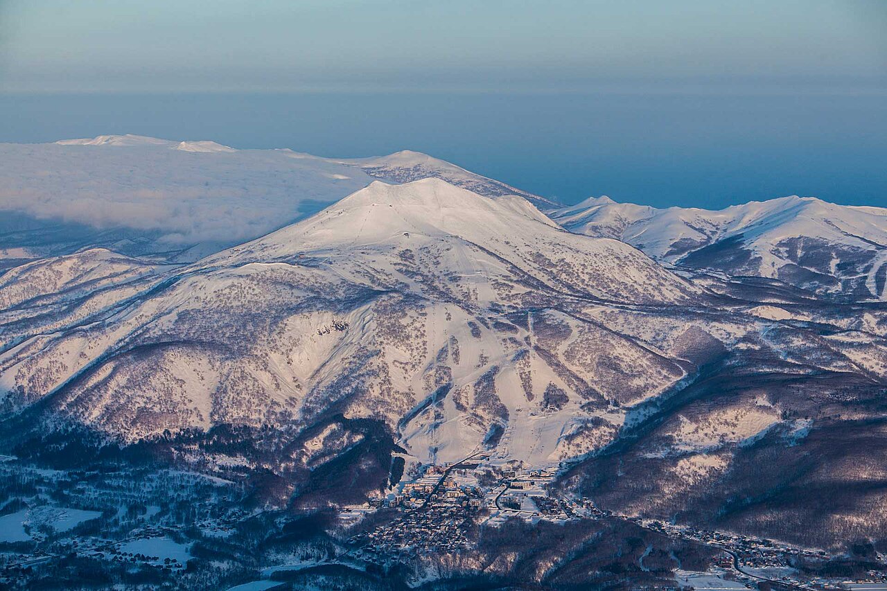
二世古联合滑雪区由北海道二世古安努普利山坡上的花园、格兰比罗夫、二世古村和安努普利四个雪场组成。它们位于同一座山上,但山脚入口、配套设施和缆车运行信息各不相同。安排集合地点或查看摄像头时,应先确认自己将从哪个雪场进入。
这里冬季的降雪与经过日本海、携带水汽的气流有关。这解释了二世古的降雪特点,却不意味着每次到访都能遇到新鲜粉雪。判断某一天是否会下新雪,应查看出行日期对应的预报,而不是把整个雪季的降雪量当作当天的依据。
本页默认预报点位于海拔257米的较低缆车区域,并不代表整座山或二世古安努普利山顶。计划前往高处滑雪时,请比较较高海拔的预报,并查看各雪场的实时缆车运行信息,确认连接路线。切换预报模型时,应保持海拔和时段一致;预报降雪量并不是地面已有积雪的实测厚度。
官方来源:Niseko United · ニセコユナイテッド。资料核对日期:2026年10月18日。
Resort cameras
Niseko United - Base lift station
ECMWF · 模式起报时间: 预计下次更新:
日期 时间(UTC) 气温(°C) 湿度(%) 风速(km/h) 风速(节) 风力(Bft) 风向 降水(mm) 新雪(cm) 气压(hPa) 零度层(m) 天气状况 | 星期三, 04/11 06:00 6.8 60 6 3 1B SW — — 1027 1330 Clear 0% cloud 09:00 2 81 4 2 1B S 0 0 1027 1580 Clear 3% cloud 12:00 0.5 85 5 3 1B SE 0 0 1027 1713 Clear 15% cloud 15:00 -0.2 84 6 3 2B SE 0 0 1026 341 Clear 4% cloud 18:00 -0.3 83 5 3 1B SE 0 0 1025 345 Cloudy 74% cloud 21:00 0.1 78 5 3 1B SE 0 0 1023 1947 Cloudy 52% cloud 星期四, 05/11 00:00 7.8 61 5 3 1B SE 0 0 1021 1985 Overcast 98% cloud 03:00 12.3 58 8 4 2B S 0 0 1017 2120 Partly cloudy 38% cloud 06:00 11.9 67 5 2 1B S 0 0 1014 2142 Overcast 100% cloud 09:00 8.2 87 5 3 1B E 0.29 0 1012 2188 Overcast 100% cloud 12:00 7.5 95 4 2 1B NE 6.6 0 1009 2245 Overcast 100% cloud 15:00 7.3 98 5 3 1B N 8.4 0 1004 2373 Overcast 100% cloud 18:00 7.4 98 7 4 2B NE 3.1 0 1002 2197 Overcast 100% cloud 21:00 6.9 97 4 2 1B N 0.23 0 1001 1925 Overcast 99% cloud 星期五, 06/11 00:00 9.4 90 2 1 1B W 0.05 0 1001 1714 Cloudy 70% cloud 03:00 12.2 64 12 6 2B W 0.16 0 999 1762 Partly cloudy 24% cloud 06:00 10.9 65 14 7 3B SW 0.20 0 998 1670 Cloudy 77% cloud 09:00 5.2 93 19 10 3B W 1.9 0 1002 1029 Cloudy 65% cloud 12:00 2.2 94 19 10 3B W 1.3 0 1004 615 Overcast 83% cloud 15:00 0.1 86 20 11 4B W 1.3 0.4 1005 318 Cloudy 68% cloud 18:00 -1.7 77 19 10 3B W 1.5 0.5 1005 < 309 Cloudy 74% cloud 21:00 -2 73 20 11 3B W 1.6 0.5 1006 < 309 Cloudy 78% cloud 星期六, 07/11 00:00 -0.6 73 23 13 4B W 1.5 0.4 1006 < 309 Cloudy 80% cloud 03:00 -0.3 74 28 15 4B W 1.7 0.5 1006 < 309 Overcast 88% cloud 06:00 -0.5 79 24 13 4B W 1.7 0.5 1007 < 309 Overcast 83% cloud 09:00 -0.5 81 24 13 4B W 2.0 0.6 1010 < 309 Cloudy 75% cloud 12:00 -0.5 83 22 12 4B NW 1.4 0.4 1013 < 309 Overcast 80% cloud 15:00 -0.6 86 20 11 4B NW 1.9 0.6 1015 < 309 Overcast 88% cloud 18:00 -0.9 88 19 10 3B NW 1.7 0.5 1018 < 309 Overcast 95% cloud 21:00 -1.2 88 17 9 3B NW 1.6 0.5 1020 < 309 Overcast 93% cloud 星期日, 08/11 00:00 -0.2 81 16 9 3B NW 1.4 0.4 1024 < 309 Overcast 93% cloud 03:00 0.5 75 18 10 3B NW 0.74 0.2 1025 353 Overcast 91% cloud 06:00 -0.1 79 15 8 3B W 0.50 0.2 1026 < 309 Overcast 95% cloud 09:00 -1.2 86 11 6 2B W 0.32 0.1 1028 < 309 Overcast 96% cloud 12:00 -1.2 80 10 5 2B W 0.15 0 1028 < 309 Overcast 97% cloud 15:00 -1.7 85 10 6 2B W 0.34 0.1 1028 < 309 Overcast 97% cloud 18:00 -2.5 86 9 5 2B W 0.57 0.2 1028 < 309 Overcast 92% cloud 21:00 -3.4 87 8 4 2B W 0.36 0.4 1028 < 309 Overcast 85% cloud 星期一, 09/11 00:00 -2.1 74 12 6 2B W 0.40 0.1 1028 < 309 Cloudy 62% cloud 03:00 -2.1 67 13 7 3B NW 0.47 0.1 1026 < 309 Overcast 88% cloud 06:00 -2.8 76 5 3 1B NW 0.71 0.2 1025 < 309 Overcast 92% cloud 09:00 -5.1 91 5 3 1B NW 2.0 2 1024 < 309 Overcast 98% cloud 12:00 -6.5 90 2 1 1B NE 1.2 1.2 1023 < 309 Overcast 85% cloud 15:00 -9.4 88 2 1 1B NW 0.29 0.3 1022 < 309 Overcast 93% cloud 18:00 -8.8 84 1 1 1B N 1.0 1 1023 < 309 Cloudy 78% cloud 21:00 -9.4 79 3 2 1B N 1.1 1.1 1025 < 309 Partly cloudy 50% cloud 星期二, 10/11 00:00 -4.3 66 3 2 1B NW 0.16 0.2 1027 < 309 Clear 10% cloud 03:00 -0.1 55 12 7 2B N 0 0 1026 < 309 Cloudy 67% cloud 06:00 -0.6 69 8 4 2B NW 0.04 0 1027 < 309 Overcast 93% cloud |
|---|
Forecast notes
Forecast table times: UTC.
Coordinates: 42.8640813°N, 140.7006193°E · Requested elevation: 305 m. Model terrain: 307 m. Terrain and 1000/925/850/700 hPa profiles are used for height estimates.
Outside the available profile, temperature uses an estimated 5.5°C/km height correction; wind retains the nearest available model-level value. Humidity is estimated with adjusted pressure and temperature.
These are altitude estimates, not a simulation of local mountain terrain. Precipitation, cloud and sea-level pressure use horizontal interpolation only.
Precipitation includes rain and snow water equivalent: preceding 3 hours through day 6, then 6 hours (see cell tooltip). Snow (cm) estimates fresh snowfall from precipitation and temperature using the GFS conversion; it is not snow depth on the ground. Freezing (m) uses additional 600/500 hPa temperatures when available and estimates the lowest resolved 0°C crossing above sea level. When all sampled levels are warm, the upper profile limit is shown (see tooltip). < marks an entirely cold sampled profile and its lower height limit. No extrapolation is used.
Source: ECMWF · CC BY 4.0 · Processed by Snow Report.
Niseko United - Top lift station
ECMWF · 模式起报时间: 预计下次更新:
日期 时间(UTC) 气温(°C) 湿度(%) 风速(km/h) 风速(节) 风力(Bft) 风向 降水(mm) 新雪(cm) 气压(hPa) 零度层(m) 天气状况 | 星期三, 04/11 06:00 0.4 45 24 13 4B W — — 1027 1320 Clear 0% cloud 09:00 1.5 33 30 16 5B SW 0 0 1027 1576 Clear 4% cloud 12:00 2.4 25 33 18 5B SW 0 0 1027 1711 Clear 17% cloud 15:00 2.3 41 31 17 5B SW 0 0 1026 1652 Clear 4% cloud 18:00 3.1 42 28 15 4B SW 0 0 1024 304 Cloudy 72% cloud 21:00 3.8 41 25 14 4B SW 0 0 1023 1941 Partly cloudy 49% cloud 星期四, 05/11 00:00 4.1 39 31 17 5B S 0 0 1021 1979 Overcast 98% cloud 03:00 5 54 24 13 4B S 0 0 1017 2116 Partly cloudy 39% cloud 06:00 5.8 73 22 12 4B S 0 0 1014 2141 Overcast 100% cloud 09:00 5.7 72 25 14 4B S 0.25 0 1012 2192 Overcast 100% cloud 12:00 5.7 88 27 15 4B SE 6.3 0 1009 2232 Overcast 100% cloud 15:00 5.5 95 18 10 3B E 8.5 0 1004 2357 Overcast 100% cloud 18:00 4.6 88 22 12 4B N 3.0 0 1002 2188 Overcast 100% cloud 21:00 3.8 87 26 14 4B NW 0.19 0 1001 1922 Overcast 100% cloud 星期五, 06/11 00:00 3.1 87 20 11 4B NW 0.09 0 1001 1716 Cloudy 69% cloud 03:00 3.8 75 31 17 5B W 0.17 0 999 1763 Partly cloudy 27% cloud 06:00 3.3 83 47 25 6B SW 0.22 0 998 1664 Cloudy 77% cloud 09:00 -1.1 87 58 31 7B W 2.2 0.7 1002 1021 Cloudy 67% cloud 12:00 -4.1 90 64 35 8B W 1.5 1.5 1004 611 Overcast 82% cloud 15:00 -7 79 75 40 8B W 1.5 1.5 1005 319 Cloudy 65% cloud 18:00 -8.6 82 74 40 8B W 1.8 1.8 1005 < 299 Cloudy 77% cloud 21:00 -8.8 77 75 40 8B W 1.7 1.7 1006 < 299 Cloudy 77% cloud 星期六, 07/11 00:00 -8.5 84 75 41 9B W 1.6 1.6 1006 < 299 Overcast 81% cloud 03:00 -8.4 82 79 42 9B W 1.9 1.9 1006 < 299 Overcast 89% cloud 06:00 -7.9 84 84 45 9B W 1.8 1.8 1007 < 299 Overcast 82% cloud 09:00 -7.2 81 83 45 9B NW 2.1 1.6 1010 < 299 Cloudy 74% cloud 12:00 -7.3 88 75 40 8B NW 1.4 1.4 1013 < 299 Cloudy 79% cloud 15:00 -7.6 90 71 38 8B NW 1.9 1.9 1015 < 299 Overcast 84% cloud 18:00 -7.6 92 68 37 8B NW 1.8 1.8 1018 < 299 Overcast 94% cloud 21:00 -7.6 88 59 32 7B NW 1.7 1.7 1021 < 299 Overcast 92% cloud 星期日, 08/11 00:00 -7.6 87 48 26 6B NW 1.5 1.5 1024 < 299 Overcast 94% cloud 03:00 -7.6 91 43 23 6B W 0.81 0.8 1025 351 Overcast 89% cloud 06:00 -7.6 91 45 24 6B W 0.53 0.5 1026 307 Overcast 95% cloud 09:00 -8.1 91 45 24 6B W 0.34 0.3 1028 < 299 Overcast 97% cloud 12:00 -8.1 90 44 24 6B W 0.16 0.2 1028 < 299 Overcast 97% cloud 15:00 -8.7 92 44 24 6B W 0.37 0.4 1028 < 299 Overcast 98% cloud 18:00 -9.1 84 44 24 6B W 0.59 0.6 1028 < 299 Overcast 93% cloud 21:00 -9.8 86 39 21 6B W 0.41 0.4 1028 < 299 Overcast 86% cloud 星期一, 09/11 00:00 -9.9 76 37 20 5B W 0.48 0.5 1028 < 299 Cloudy 62% cloud 03:00 -10.4 82 33 18 5B W 0.57 0.6 1026 < 299 Overcast 89% cloud 06:00 -10.3 88 23 13 4B W 0.80 0.8 1024 < 299 Overcast 93% cloud 09:00 -10.5 86 24 13 4B NW 2.3 1.8 1024 < 299 Overcast 98% cloud 12:00 -11.1 73 19 10 3B NW 1.3 1.3 1023 < 299 Overcast 84% cloud 15:00 -11.6 84 17 9 3B NW 0.34 0.3 1022 < 299 Overcast 94% cloud 18:00 -11.8 78 24 13 4B NW 1.2 1.2 1023 < 299 Overcast 81% cloud 21:00 -12.1 78 37 20 5B N 1.2 1.2 1025 < 299 Cloudy 50% cloud 星期二, 10/11 00:00 -10.6 59 37 20 5B N 0.16 0.2 1027 < 299 Clear 11% cloud 03:00 -8.9 78 26 14 4B N 0 0 1026 < 299 Cloudy 70% cloud 06:00 -8.4 87 20 11 4B NW 0.06 0.1 1027 < 299 Overcast 93% cloud |
|---|
Forecast notes
Forecast table times: UTC.
Coordinates: 42.8708178°N, 140.6624025°E · Requested elevation: 1183 m. Model terrain: 297 m. Terrain and 1000/925/850/700 hPa profiles are used for height estimates.
These are altitude estimates, not a simulation of local mountain terrain. Precipitation, cloud and sea-level pressure use horizontal interpolation only.
Precipitation includes rain and snow water equivalent: preceding 3 hours through day 6, then 6 hours (see cell tooltip). Snow (cm) estimates fresh snowfall from precipitation and temperature using the GFS conversion; it is not snow depth on the ground. Freezing (m) uses additional 600/500 hPa temperatures when available and estimates the lowest resolved 0°C crossing above sea level. When all sampled levels are warm, the upper profile limit is shown (see tooltip). < marks an entirely cold sampled profile and its lower height limit. No extrapolation is used.