SNOWREPORT
METEOCAM
Prévisions pour les stations de ski du monde entier
Modèles météo GFS, ECMWF & ICON
Prévisions jusqu’à 16 jours
2,272 stations de ski Nouvelle station : Moose Mountain Ski Resort ↗
125 webcams de montagne Nouvelle webcam : Skeetawk ↗
Expertise météo en montagne depuis 1996

Plus
Mémoriser ce lieu, cette altitude, ce modèle et cette vue dans ce navigateur.
Guide des couleurs Température · Vent · Pluie · Neige
Température °C< −10 / −10 / 0 / 10 / 20 / 30+
Vent km/h< 10 / 10 / 29 / 50 / 75+
Pluie mm< 1 / 1 / 3 / 10 / 20+
Neige cm< 1 / 1 / 5 / 10 / 20+
Chaque couleur commence à la valeur indiquée. Les couleurs du vent correspondent dans les trois unités. Les cases sans précipitations restent neutres. Les couleurs décrivent les valeurs affichées et ne sont pas des alertes officielles.
Préparation des graphiques…
Les heures et valeurs correspondent aux prévisions détaillées. Touchez une valeur pour plus de détails et faites défiler horizontalement pour les jours suivants. Les précipitations représentent l’équivalent en eau total par intervalle, neige comprise. La neige fraîche correspond à chaque intervalle, et non à l’épaisseur au sol.
Comparaison GFS et ECMWF. Chaque modèle conserve ses heures et son horizon de prévision. Les quantités de précipitations et de neige couvrent leurs propres intervalles, qui peuvent différer entre modèles.
Valeurs des prévisions et notes des modèles
Niseko United - Low lift station
ECMWF · Cycle du modèle : Prochaine mise à jour attendue :
Jour Heure (UTC) Temp. (°C) Humidité (%) Vent (km/h) Vent (nœuds) Vent (Bft) Direction Précip. (mm) Neige fraîche (cm) Pression (hPa) Isotherme 0 °C (m) Conditions | Mercredi, 04/11 06:00 7.1 58 6 3 1B SW — — 1027 1334 Clear 0% cloud  09:00 2.3 80 4 2 1B S 0 0 1027 1581 Clear 3% cloud 12:00 0.7 84 5 2 1B SE 0 0 1027 1714 Clear 15% cloud 15:00 -0 83 6 3 1B SE 0 0 1026 347 Clear 4% cloud 18:00 -0.1 82 5 3 1B SE 0 0 1025 351 Cloudy 74% cloud  21:00 0.4 78 5 3 1B SE 0 0 1023 1947 Cloudy 53% cloud Jeudi, 05/11 00:00 8.1 61 5 3 1B SE 0 0 1021 1985 Overcast 98% cloud  03:00 12.6 57 8 4 2B S 0 0 1017 2121 Partly cloudy 37% cloud  06:00 12.2 66 5 2 1B S 0 0 1014 2143 Overcast 100% cloud 09:00 8.4 86 5 3 1B E 0.31 0 1012 2188 Overcast 100% cloud 12:00 7.8 94 4 2 1B NE 6.7 0 1009 2247 Overcast 100% cloud 15:00 7.5 97 5 3 1B N 8.4 0 1004 2376 Overcast 100% cloud 18:00 7.6 97 7 4 2B N 3.1 0 1002 2200 Overcast 100% cloud 21:00 7.1 95 4 2 1B N 0.23 0 1001 1927 Overcast 99% cloud Vendredi, 06/11 00:00 9.7 89 2 1 1B W 0.05 0 1001 1715 Cloudy 69% cloud 03:00 12.5 63 12 6 2B W 0.16 0 999 1763 Partly cloudy 24% cloud 06:00 11.2 64 14 7 3B SW 0.20 0 998 1670 Cloudy 77% cloud 09:00 5.4 92 19 10 3B W 1.9 0 1002 1031 Cloudy 64% cloud 12:00 2.4 92 19 10 3B W 1.2 0 1004 616 Overcast 83% cloud 15:00 0.3 84 20 11 3B W 1.3 0.4 1005 317 Cloudy 68% cloud 18:00 -1.4 76 18 10 3B W 1.5 0.4 1005 < 310 Cloudy 74% cloud 21:00 -1.8 72 19 10 3B W 1.6 0.5 1006 < 310 Cloudy 78% cloud Samedi, 07/11 00:00 -0.3 72 23 13 4B W 1.5 0.4 1006 < 310 Cloudy 79% cloud 03:00 -0 73 28 15 4B W 1.7 0.5 1006 < 310 Overcast 88% cloud 06:00 -0.2 78 24 13 4B W 1.7 0.5 1007 < 310 Overcast 83% cloud 09:00 -0.2 80 24 13 4B W 2.0 0.6 1010 < 310 Cloudy 75% cloud 12:00 -0.3 81 21 11 4B NW 1.4 0.4 1013 < 310 Overcast 81% cloud 15:00 -0.4 85 20 11 4B NW 1.9 0.6 1015 < 310 Overcast 88% cloud 18:00 -0.6 87 18 10 3B NW 1.7 0.5 1018 < 310 Overcast 96% cloud 21:00 -0.9 87 17 9 3B NW 1.6 0.5 1020 < 310 Overcast 93% cloud Dimanche, 08/11 00:00 0.1 80 16 9 3B NW 1.4 0.4 1024 < 310 Overcast 93% cloud 03:00 0.7 74 18 10 3B NW 0.75 0.2 1025 354 Overcast 91% cloud 06:00 0.2 78 15 8 3B W 0.50 0.1 1026 < 310 Overcast 95% cloud 09:00 -1 85 11 6 2B W 0.32 0.1 1028 < 310 Overcast 96% cloud 12:00 -1 79 10 5 2B W 0.15 0 1028 < 310 Overcast 97% cloud 15:00 -1.5 84 10 5 2B W 0.33 0.1 1028 < 310 Overcast 97% cloud 18:00 -2.3 85 9 5 2B W 0.57 0.2 1028 < 310 Overcast 92% cloud 21:00 -3.1 86 7 4 2B W 0.35 0.4 1028 < 310 Overcast 85% cloud Lundi, 09/11 00:00 -1.9 73 12 6 2B W 0.39 0.1 1028 < 310 Cloudy 62% cloud 03:00 -1.8 66 13 7 3B NW 0.46 0.1 1026 < 310 Overcast 88% cloud 06:00 -2.6 75 5 3 1B NW 0.70 0.2 1025 < 310 Overcast 91% cloud 09:00 -4.9 89 5 3 1B NW 1.9 1.9 1024 < 310 Overcast 98% cloud 12:00 -6.2 89 2 1 1B N 1.2 1.2 1023 < 310 Overcast 85% cloud 15:00 -9.1 86 2 1 1B NW 0.28 0.3 1022 < 310 Overcast 93% cloud 18:00 -8.6 83 1 1 1B N 1.00 1 1023 < 310 Cloudy 77% cloud 21:00 -9.2 78 3 2 1B N 1.0 1 1025 < 310 Partly cloudy 50% cloud Mardi, 10/11 00:00 -4.1 65 3 2 1B NW 0.15 0.2 1027 < 310 Clear 10% cloud 03:00 0.1 55 12 7 2B N 0 0 1026 < 310 Cloudy 66% cloud 06:00 -0.3 68 8 4 2B NW 0.04 0 1027 < 310 Overcast 93% cloud |
|---|
Forecast notes
Forecast table times: UTC.
Coordinates: 42.8583452°N, 140.7020096°E · Requested elevation: 257 m. Model terrain: 308 m. Terrain and 1000/925/850/700 hPa profiles are used for height estimates.
Outside the available profile, temperature uses an estimated 5.5°C/km height correction; wind retains the nearest available model-level value. Humidity is estimated with adjusted pressure and temperature.
These are altitude estimates, not a simulation of local mountain terrain. Precipitation, cloud and sea-level pressure use horizontal interpolation only.
Precipitation includes rain and snow water equivalent: preceding 3 hours through day 6, then 6 hours (see cell tooltip). Snow (cm) estimates fresh snowfall from precipitation and temperature using the GFS conversion; it is not snow depth on the ground. Freezing (m) uses additional 600/500 hPa temperatures when available and estimates the lowest resolved 0°C crossing above sea level. When all sampled levels are warm, the upper profile limit is shown (see tooltip). < marks an entirely cold sampled profile and its lower height limit. No extrapolation is used.
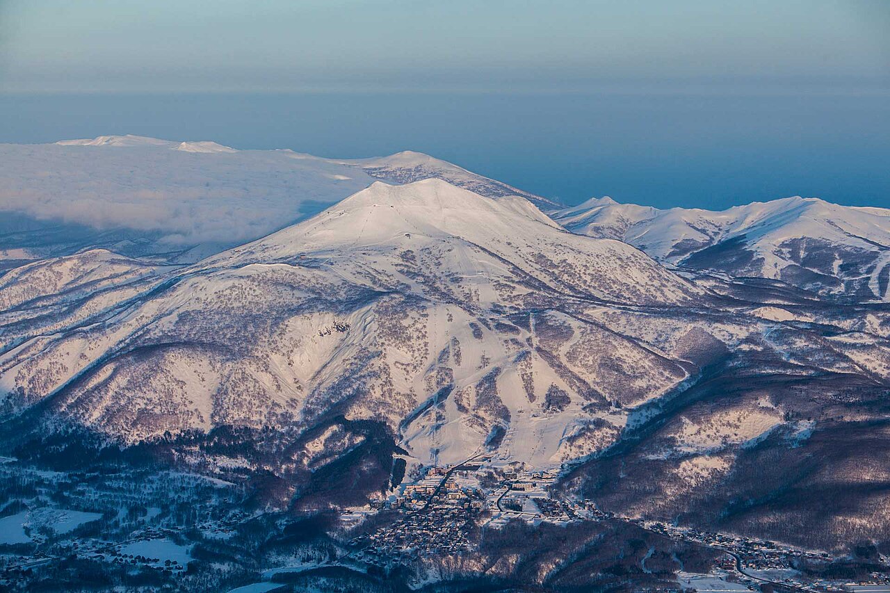
Niseko United réunit Hanazono, Grand Hirafu, Niseko Village et Annupuri sur les pentes du Niseko Annupuri, à Hokkaido. La montagne commune explique ce regroupement, mais les bases restent distinctes, avec leurs installations et leurs informations de remontées. Identifiez celle que vous utiliserez pour un rendez-vous ou pour interpréter une webcam.
Les chutes hivernales de la région sont liées à l’air qui se charge en humidité au-dessus de la mer du Japon. Cela explique sa réputation, sans promettre de la poudreuse fraîche à chaque séjour. Pour une journée précise, consultez la prévision à vos dates plutôt qu’un cumul saisonnier.
Notre référence par défaut est un point bas de remontée à 257 m. Elle ne représente ni toute la montagne ni le sommet du Niseko Annupuri. Choisissez un point plus haut pour les pistes supérieures et consultez les ouvertures de chaque station pour les liaisons. Gardez la même altitude et la même période en changeant de modèle : les cumuls sont des prévisions, pas des relevés de neige déjà au sol.
Sources officielles: Niseko United · ニセコユナイテッド. Informations vérifiées le 18 octobre 2026.
Resort cameras
Préparation des graphiques…
Les heures et valeurs correspondent aux prévisions détaillées. Touchez une valeur pour plus de détails et faites défiler horizontalement pour les jours suivants. Les précipitations représentent l’équivalent en eau total par intervalle, neige comprise. La neige fraîche correspond à chaque intervalle, et non à l’épaisseur au sol.
Comparaison GFS et ECMWF. Chaque modèle conserve ses heures et son horizon de prévision. Les quantités de précipitations et de neige couvrent leurs propres intervalles, qui peuvent différer entre modèles.
Valeurs des prévisions et notes des modèles
Niseko United - Base lift station
ECMWF · Cycle du modèle : Prochaine mise à jour attendue :
Jour Heure (UTC) Temp. (°C) Humidité (%) Vent (km/h) Vent (nœuds) Vent (Bft) Direction Précip. (mm) Neige fraîche (cm) Pression (hPa) Isotherme 0 °C (m) Conditions | Mercredi, 04/11 06:00 6.8 60 6 3 1B SW — — 1027 1330 Clear 0% cloud 09:00 2 81 4 2 1B S 0 0 1027 1580 Clear 3% cloud 12:00 0.5 85 5 3 1B SE 0 0 1027 1713 Clear 15% cloud 15:00 -0.2 84 6 3 2B SE 0 0 1026 341 Clear 4% cloud 18:00 -0.3 83 5 3 1B SE 0 0 1025 345 Cloudy 74% cloud 21:00 0.1 78 5 3 1B SE 0 0 1023 1947 Cloudy 52% cloud Jeudi, 05/11 00:00 7.8 61 5 3 1B SE 0 0 1021 1985 Overcast 98% cloud 03:00 12.3 58 8 4 2B S 0 0 1017 2120 Partly cloudy 38% cloud 06:00 11.9 67 5 2 1B S 0 0 1014 2142 Overcast 100% cloud 09:00 8.2 87 5 3 1B E 0.29 0 1012 2188 Overcast 100% cloud 12:00 7.5 95 4 2 1B NE 6.6 0 1009 2245 Overcast 100% cloud 15:00 7.3 98 5 3 1B N 8.4 0 1004 2373 Overcast 100% cloud 18:00 7.4 98 7 4 2B NE 3.1 0 1002 2197 Overcast 100% cloud 21:00 6.9 97 4 2 1B N 0.23 0 1001 1925 Overcast 99% cloud Vendredi, 06/11 00:00 9.4 90 2 1 1B W 0.05 0 1001 1714 Cloudy 70% cloud 03:00 12.2 64 12 6 2B W 0.16 0 999 1762 Partly cloudy 24% cloud 06:00 10.9 65 14 7 3B SW 0.20 0 998 1670 Cloudy 77% cloud 09:00 5.2 93 19 10 3B W 1.9 0 1002 1029 Cloudy 65% cloud 12:00 2.2 94 19 10 3B W 1.3 0 1004 615 Overcast 83% cloud 15:00 0.1 86 20 11 4B W 1.3 0.4 1005 318 Cloudy 68% cloud 18:00 -1.7 77 19 10 3B W 1.5 0.5 1005 < 309 Cloudy 74% cloud 21:00 -2 73 20 11 3B W 1.6 0.5 1006 < 309 Cloudy 78% cloud Samedi, 07/11 00:00 -0.6 73 23 13 4B W 1.5 0.4 1006 < 309 Cloudy 80% cloud 03:00 -0.3 74 28 15 4B W 1.7 0.5 1006 < 309 Overcast 88% cloud 06:00 -0.5 79 24 13 4B W 1.7 0.5 1007 < 309 Overcast 83% cloud 09:00 -0.5 81 24 13 4B W 2.0 0.6 1010 < 309 Cloudy 75% cloud 12:00 -0.5 83 22 12 4B NW 1.4 0.4 1013 < 309 Overcast 80% cloud 15:00 -0.6 86 20 11 4B NW 1.9 0.6 1015 < 309 Overcast 88% cloud 18:00 -0.9 88 19 10 3B NW 1.7 0.5 1018 < 309 Overcast 95% cloud 21:00 -1.2 88 17 9 3B NW 1.6 0.5 1020 < 309 Overcast 93% cloud Dimanche, 08/11 00:00 -0.2 81 16 9 3B NW 1.4 0.4 1024 < 309 Overcast 93% cloud 03:00 0.5 75 18 10 3B NW 0.74 0.2 1025 353 Overcast 91% cloud 06:00 -0.1 79 15 8 3B W 0.50 0.2 1026 < 309 Overcast 95% cloud 09:00 -1.2 86 11 6 2B W 0.32 0.1 1028 < 309 Overcast 96% cloud 12:00 -1.2 80 10 5 2B W 0.15 0 1028 < 309 Overcast 97% cloud 15:00 -1.7 85 10 6 2B W 0.34 0.1 1028 < 309 Overcast 97% cloud 18:00 -2.5 86 9 5 2B W 0.57 0.2 1028 < 309 Overcast 92% cloud 21:00 -3.4 87 8 4 2B W 0.36 0.4 1028 < 309 Overcast 85% cloud Lundi, 09/11 00:00 -2.1 74 12 6 2B W 0.40 0.1 1028 < 309 Cloudy 62% cloud 03:00 -2.1 67 13 7 3B NW 0.47 0.1 1026 < 309 Overcast 88% cloud 06:00 -2.8 76 5 3 1B NW 0.71 0.2 1025 < 309 Overcast 92% cloud 09:00 -5.1 91 5 3 1B NW 2.0 2 1024 < 309 Overcast 98% cloud 12:00 -6.5 90 2 1 1B NE 1.2 1.2 1023 < 309 Overcast 85% cloud 15:00 -9.4 88 2 1 1B NW 0.29 0.3 1022 < 309 Overcast 93% cloud 18:00 -8.8 84 1 1 1B N 1.0 1 1023 < 309 Cloudy 78% cloud 21:00 -9.4 79 3 2 1B N 1.1 1.1 1025 < 309 Partly cloudy 50% cloud Mardi, 10/11 00:00 -4.3 66 3 2 1B NW 0.16 0.2 1027 < 309 Clear 10% cloud 03:00 -0.1 55 12 7 2B N 0 0 1026 < 309 Cloudy 67% cloud 06:00 -0.6 69 8 4 2B NW 0.04 0 1027 < 309 Overcast 93% cloud |
|---|
Forecast notes
Forecast table times: UTC.
Coordinates: 42.8640813°N, 140.7006193°E · Requested elevation: 305 m. Model terrain: 307 m. Terrain and 1000/925/850/700 hPa profiles are used for height estimates.
Outside the available profile, temperature uses an estimated 5.5°C/km height correction; wind retains the nearest available model-level value. Humidity is estimated with adjusted pressure and temperature.
These are altitude estimates, not a simulation of local mountain terrain. Precipitation, cloud and sea-level pressure use horizontal interpolation only.
Precipitation includes rain and snow water equivalent: preceding 3 hours through day 6, then 6 hours (see cell tooltip). Snow (cm) estimates fresh snowfall from precipitation and temperature using the GFS conversion; it is not snow depth on the ground. Freezing (m) uses additional 600/500 hPa temperatures when available and estimates the lowest resolved 0°C crossing above sea level. When all sampled levels are warm, the upper profile limit is shown (see tooltip). < marks an entirely cold sampled profile and its lower height limit. No extrapolation is used.
Préparation des graphiques…
Les heures et valeurs correspondent aux prévisions détaillées. Touchez une valeur pour plus de détails et faites défiler horizontalement pour les jours suivants. Les précipitations représentent l’équivalent en eau total par intervalle, neige comprise. La neige fraîche correspond à chaque intervalle, et non à l’épaisseur au sol.
Comparaison GFS et ECMWF. Chaque modèle conserve ses heures et son horizon de prévision. Les quantités de précipitations et de neige couvrent leurs propres intervalles, qui peuvent différer entre modèles.
Valeurs des prévisions et notes des modèles
Niseko United - Top lift station
ECMWF · Cycle du modèle : Prochaine mise à jour attendue :
Jour Heure (UTC) Temp. (°C) Humidité (%) Vent (km/h) Vent (nœuds) Vent (Bft) Direction Précip. (mm) Neige fraîche (cm) Pression (hPa) Isotherme 0 °C (m) Conditions | Mercredi, 04/11 06:00 0.4 45 24 13 4B W — — 1027 1320 Clear 0% cloud 09:00 1.5 33 30 16 5B SW 0 0 1027 1576 Clear 4% cloud 12:00 2.4 25 33 18 5B SW 0 0 1027 1711 Clear 17% cloud 15:00 2.3 41 31 17 5B SW 0 0 1026 1652 Clear 4% cloud 18:00 3.1 42 28 15 4B SW 0 0 1024 304 Cloudy 72% cloud 21:00 3.8 41 25 14 4B SW 0 0 1023 1941 Partly cloudy 49% cloud Jeudi, 05/11 00:00 4.1 39 31 17 5B S 0 0 1021 1979 Overcast 98% cloud 03:00 5 54 24 13 4B S 0 0 1017 2116 Partly cloudy 39% cloud 06:00 5.8 73 22 12 4B S 0 0 1014 2141 Overcast 100% cloud 09:00 5.7 72 25 14 4B S 0.25 0 1012 2192 Overcast 100% cloud 12:00 5.7 88 27 15 4B SE 6.3 0 1009 2232 Overcast 100% cloud 15:00 5.5 95 18 10 3B E 8.5 0 1004 2357 Overcast 100% cloud 18:00 4.6 88 22 12 4B N 3.0 0 1002 2188 Overcast 100% cloud 21:00 3.8 87 26 14 4B NW 0.19 0 1001 1922 Overcast 100% cloud Vendredi, 06/11 00:00 3.1 87 20 11 4B NW 0.09 0 1001 1716 Cloudy 69% cloud 03:00 3.8 75 31 17 5B W 0.17 0 999 1763 Partly cloudy 27% cloud 06:00 3.3 83 47 25 6B SW 0.22 0 998 1664 Cloudy 77% cloud 09:00 -1.1 87 58 31 7B W 2.2 0.7 1002 1021 Cloudy 67% cloud 12:00 -4.1 90 64 35 8B W 1.5 1.5 1004 611 Overcast 82% cloud 15:00 -7 79 75 40 8B W 1.5 1.5 1005 319 Cloudy 65% cloud 18:00 -8.6 82 74 40 8B W 1.8 1.8 1005 < 299 Cloudy 77% cloud 21:00 -8.8 77 75 40 8B W 1.7 1.7 1006 < 299 Cloudy 77% cloud Samedi, 07/11 00:00 -8.5 84 75 41 9B W 1.6 1.6 1006 < 299 Overcast 81% cloud 03:00 -8.4 82 79 42 9B W 1.9 1.9 1006 < 299 Overcast 89% cloud 06:00 -7.9 84 84 45 9B W 1.8 1.8 1007 < 299 Overcast 82% cloud 09:00 -7.2 81 83 45 9B NW 2.1 1.6 1010 < 299 Cloudy 74% cloud 12:00 -7.3 88 75 40 8B NW 1.4 1.4 1013 < 299 Cloudy 79% cloud 15:00 -7.6 90 71 38 8B NW 1.9 1.9 1015 < 299 Overcast 84% cloud 18:00 -7.6 92 68 37 8B NW 1.8 1.8 1018 < 299 Overcast 94% cloud 21:00 -7.6 88 59 32 7B NW 1.7 1.7 1021 < 299 Overcast 92% cloud Dimanche, 08/11 00:00 -7.6 87 48 26 6B NW 1.5 1.5 1024 < 299 Overcast 94% cloud 03:00 -7.6 91 43 23 6B W 0.81 0.8 1025 351 Overcast 89% cloud 06:00 -7.6 91 45 24 6B W 0.53 0.5 1026 307 Overcast 95% cloud 09:00 -8.1 91 45 24 6B W 0.34 0.3 1028 < 299 Overcast 97% cloud 12:00 -8.1 90 44 24 6B W 0.16 0.2 1028 < 299 Overcast 97% cloud 15:00 -8.7 92 44 24 6B W 0.37 0.4 1028 < 299 Overcast 98% cloud 18:00 -9.1 84 44 24 6B W 0.59 0.6 1028 < 299 Overcast 93% cloud 21:00 -9.8 86 39 21 6B W 0.41 0.4 1028 < 299 Overcast 86% cloud Lundi, 09/11 00:00 -9.9 76 37 20 5B W 0.48 0.5 1028 < 299 Cloudy 62% cloud 03:00 -10.4 82 33 18 5B W 0.57 0.6 1026 < 299 Overcast 89% cloud 06:00 -10.3 88 23 13 4B W 0.80 0.8 1024 < 299 Overcast 93% cloud 09:00 -10.5 86 24 13 4B NW 2.3 1.8 1024 < 299 Overcast 98% cloud 12:00 -11.1 73 19 10 3B NW 1.3 1.3 1023 < 299 Overcast 84% cloud 15:00 -11.6 84 17 9 3B NW 0.34 0.3 1022 < 299 Overcast 94% cloud 18:00 -11.8 78 24 13 4B NW 1.2 1.2 1023 < 299 Overcast 81% cloud 21:00 -12.1 78 37 20 5B N 1.2 1.2 1025 < 299 Cloudy 50% cloud Mardi, 10/11 00:00 -10.6 59 37 20 5B N 0.16 0.2 1027 < 299 Clear 11% cloud 03:00 -8.9 78 26 14 4B N 0 0 1026 < 299 Cloudy 70% cloud 06:00 -8.4 87 20 11 4B NW 0.06 0.1 1027 < 299 Overcast 93% cloud |
|---|
Forecast notes
Forecast table times: UTC.
Coordinates: 42.8708178°N, 140.6624025°E · Requested elevation: 1183 m. Model terrain: 297 m. Terrain and 1000/925/850/700 hPa profiles are used for height estimates.
These are altitude estimates, not a simulation of local mountain terrain. Precipitation, cloud and sea-level pressure use horizontal interpolation only.
Precipitation includes rain and snow water equivalent: preceding 3 hours through day 6, then 6 hours (see cell tooltip). Snow (cm) estimates fresh snowfall from precipitation and temperature using the GFS conversion; it is not snow depth on the ground. Freezing (m) uses additional 600/500 hPa temperatures when available and estimates the lowest resolved 0°C crossing above sea level. When all sampled levels are warm, the upper profile limit is shown (see tooltip). < marks an entirely cold sampled profile and its lower height limit. No extrapolation is used.