Wettervorhersagen für Skigebiete weltweit

Farbskala Temperatur · Wind · Regen · Schnee
Jede Farbe beginnt beim angegebenen Wert. Die Windfarben stimmen in allen drei Einheiten überein. Trockene Zellen bleiben neutral. Die Farben beschreiben die Werte und sind keine amtlichen Wetterwarnungen.
Mount Ashland - Low lift station
ECMWF · Modelllauf: Nächste Aktualisierung erwartet:
Tag Uhrzeit (UTC) Temp. (°C) Luftfeuchtigkeit (%) Wind (km/h) Wind (Knoten) Wind (Bft) Richtung Niederschlag (mm) Neuschnee (cm) Luftdruck (hPa) Nullgradgrenze (m) Wetterlage | Mittwoch, 04/11 06:00 1.8 77 3 2 1B NE — — 1020 2230 Partly cloudy 27% cloud  09:00 1.9 77 4 2 1B E 0 0 1020 2279 Clear 8% cloud  12:00 2.3 71 3 2 1B SE 0 0 1020 2408 Clear 12% cloud 15:00 2.6 68 5 3 1B SE 0 0 1020 2608 Clear 17% cloud 18:00 2.8 66 7 4 2B S 0 0 1020 2603 Partly cloudy 30% cloud 21:00 4.9 56 8 5 2B W 0 0 1018 2930 Overcast 96% cloud  Donnerstag, 05/11 00:00 4.3 63 15 8 3B NW 0 0 1019 2630 Overcast 100% cloud 03:00 3.7 81 16 9 3B NW 0.51 0 1021 2655 Overcast 100% cloud 06:00 3.1 75 13 7 3B W 0 0 1022 2473 Overcast 97% cloud 09:00 3.2 66 15 8 3B NW 0 0 1022 2663 Partly cloudy 26% cloud 12:00 2.6 73 18 10 3B NW 0.03 0 1023 2749 Partly cloudy 43% cloud 15:00 2.3 73 15 8 3B N 0.01 0 1024 2805 Cloudy 68% cloud  18:00 2.8 60 7 4 2B N 0 0 1025 3114 Overcast 82% cloud 21:00 5.3 44 4 2 1B W 0 0 1022 3118 Partly cloudy 34% cloud Freitag, 06/11 00:00 6.3 47 5 3 1B W 0 0 1022 3121 Cloudy 76% cloud 03:00 6.7 47 0 0 0B SE 0 0 1022 3126 Overcast 98% cloud 06:00 7.1 32 6 3 2B S 0 0 1023 3136 Clear 2% cloud 09:00 7.7 32 8 4 2B SW 0 0 1023 3142 Cloudy 65% cloud 12:00 7.9 37 8 4 2B SW 0 0 1022 3140 Overcast 89% cloud 15:00 8.1 34 7 4 2B W 0 0 1023 3149 Cloudy 63% cloud 18:00 8.2 33 8 4 2B SW 0 0 1024 3158 Overcast 98% cloud 21:00 9.8 30 9 5 2B W 0 0 1022 3154 Clear 18% cloud Samstag, 07/11 00:00 10.2 33 6 3 1B W 0 0 1022 3153 Clear 0% cloud 03:00 10.1 36 2 1 1B W 0 0 1022 3158 Clear 0% cloud 06:00 10.5 32 5 3 1B S 0 0 1022 3161 Cloudy 60% cloud 09:00 11 28 11 6 2B S 0 0 1021 3155 Clear 9% cloud 12:00 11.5 27 13 7 3B S 0 0 1020 3149 Clear 0% cloud 15:00 12 25 18 10 3B S 0 0 1018 3143 Clear 0% cloud 18:00 12.2 27 22 12 4B S 0 0 1018 3143 Clear 0% cloud 21:00 12.8 29 25 13 4B S 0 0 1016 3130 Cloudy 60% cloud Sonntag, 08/11 00:00 12.1 35 27 14 4B SW 0 0 1016 3121 Cloudy 77% cloud 03:00 10.8 37 28 15 4B SW 0 0 1016 3114 Overcast 82% cloud 06:00 9.8 37 31 17 5B SW 0 0 1018 3113 Clear 19% cloud 09:00 7.7 48 32 18 5B SW 0 0 1019 3111 Cloudy 71% cloud 12:00 6.7 62 32 17 5B SW 0.03 0 1020 3088 Overcast 100% cloud 15:00 5.3 78 20 11 3B SW 0.20 0 1022 2938 Overcast 100% cloud 18:00 4.5 85 11 6 2B W 0.44 0 1024 2978 Overcast 99% cloud 21:00 4.9 80 9 5 2B SW 0.46 0 1022 3108 Overcast 99% cloud Montag, 09/11 00:00 5.2 79 10 5 2B SW 0.07 0 1020 3102 Overcast 97% cloud 03:00 4.6 82 12 6 2B SW 0 0 1020 2879 Overcast 98% cloud 06:00 4.5 76 14 8 3B SW 0 0 1021 2974 Overcast 96% cloud 09:00 5 70 15 8 3B SW 0 0 1020 3094 Overcast 86% cloud 12:00 5 73 15 8 3B SW 0 0 1020 3092 Overcast 99% cloud 15:00 4.6 74 14 7 3B SW 0 0 1021 3097 Cloudy 74% cloud 18:00 5 71 15 8 3B SW 0 0 1021 3107 Overcast 83% cloud 21:00 6.9 57 14 8 3B SW 0 0 1020 3106 Cloudy 68% cloud Dienstag, 10/11 00:00 7.6 52 12 6 2B SW 0 0 1019 3112 Clear 1% cloud 03:00 7.1 55 11 6 2B SW 0 0 1020 3118 Clear 4% cloud 06:00 7.1 53 14 8 3B SW 0 0 1021 3126 Cloudy 64% cloud |
|---|
Forecast notes
Forecast table times: UTC.
Coordinates: 42.0844397°N, -122.7074565°E · Requested elevation: 1925 m. Model terrain: 1233 m. Terrain and 1000/925/850/700 hPa profiles are used for height estimates.
These are altitude estimates, not a simulation of local mountain terrain. Precipitation, cloud and sea-level pressure use horizontal interpolation only.
Precipitation includes rain and snow water equivalent: preceding 3 hours through day 6, then 6 hours (see cell tooltip). Snow (cm) estimates fresh snowfall from precipitation and temperature using the GFS conversion; it is not snow depth on the ground. Freezing (m) uses additional 600/500 hPa temperatures when available and estimates the lowest resolved 0°C crossing above sea level. When all sampled levels are warm, the upper profile limit is shown (see tooltip). < marks an entirely cold sampled profile and its lower height limit. No extrapolation is used.
Source: ECMWF · CC BY 4.0 · Processed by Snow Report.
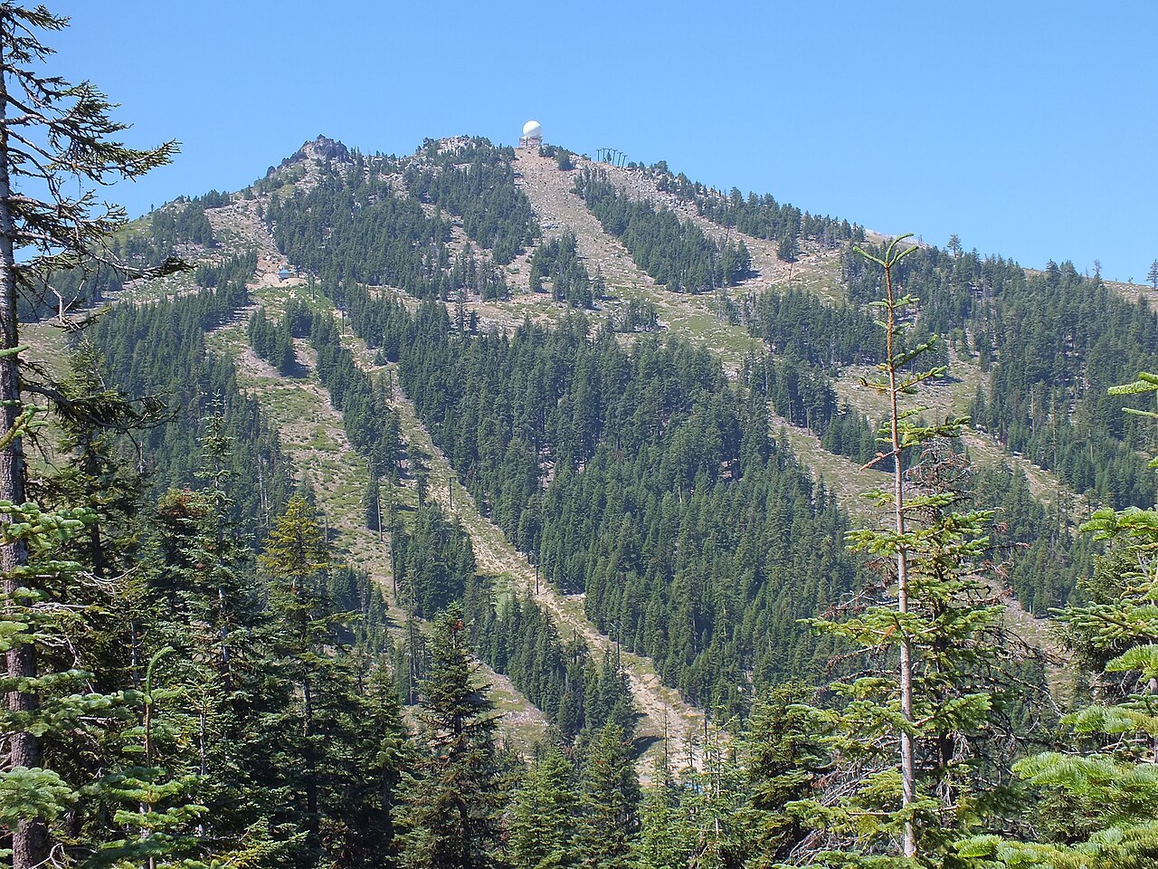
Mount Ashland is a downhill ski area in Oregon, United States. Mapped terrain includes easy, intermediate, advanced, expert routes. Its mapped lift network extends from approximately 1925 to 2279 metres above sea level.
Data: OpenSkiData / OpenSkiMap, OpenStreetMap contributors (ODbL), Skimap.org, Who's On First, Mapterhorn.
Mount Ashland - Base lift station
ECMWF · Modelllauf: Nächste Aktualisierung erwartet:
Tag Uhrzeit (UTC) Temp. (°C) Luftfeuchtigkeit (%) Wind (km/h) Wind (Knoten) Wind (Bft) Richtung Niederschlag (mm) Neuschnee (cm) Luftdruck (hPa) Nullgradgrenze (m) Wetterlage | Mittwoch, 04/11 06:00 1.8 77 3 2 1B NE — — 1020 2230 Partly cloudy 27% cloud 09:00 1.9 77 4 2 1B E 0 0 1020 2279 Clear 8% cloud 12:00 2.3 71 3 2 1B SE 0 0 1020 2408 Clear 12% cloud 15:00 2.6 68 5 3 1B SE 0 0 1020 2608 Clear 17% cloud 18:00 2.8 66 7 4 2B S 0 0 1020 2603 Partly cloudy 30% cloud 21:00 4.9 56 8 5 2B W 0 0 1018 2930 Overcast 96% cloud Donnerstag, 05/11 00:00 4.3 63 15 8 3B NW 0 0 1019 2630 Overcast 100% cloud 03:00 3.7 81 16 9 3B NW 0.51 0 1021 2655 Overcast 100% cloud 06:00 3.1 75 13 7 3B W 0 0 1022 2473 Overcast 97% cloud 09:00 3.2 66 15 8 3B NW 0 0 1022 2663 Partly cloudy 26% cloud 12:00 2.6 73 18 10 3B NW 0.03 0 1023 2749 Partly cloudy 43% cloud 15:00 2.3 73 15 8 3B N 0.01 0 1024 2805 Cloudy 68% cloud 18:00 2.8 60 7 4 2B N 0 0 1025 3114 Overcast 82% cloud 21:00 5.3 44 4 2 1B W 0 0 1022 3118 Partly cloudy 34% cloud Freitag, 06/11 00:00 6.3 47 5 3 1B W 0 0 1022 3121 Cloudy 76% cloud 03:00 6.7 47 0 0 0B SE 0 0 1022 3126 Overcast 98% cloud 06:00 7.1 32 6 3 2B S 0 0 1023 3136 Clear 2% cloud 09:00 7.7 32 8 4 2B SW 0 0 1023 3142 Cloudy 65% cloud 12:00 7.9 37 8 4 2B SW 0 0 1022 3140 Overcast 89% cloud 15:00 8.1 34 7 4 2B W 0 0 1023 3149 Cloudy 63% cloud 18:00 8.2 33 8 4 2B SW 0 0 1024 3158 Overcast 98% cloud 21:00 9.8 30 9 5 2B W 0 0 1022 3154 Clear 18% cloud Samstag, 07/11 00:00 10.2 33 6 3 1B W 0 0 1022 3153 Clear 0% cloud 03:00 10.1 36 2 1 1B W 0 0 1022 3158 Clear 0% cloud 06:00 10.5 32 5 3 1B S 0 0 1022 3161 Cloudy 60% cloud 09:00 11 28 11 6 2B S 0 0 1021 3155 Clear 9% cloud 12:00 11.5 27 13 7 3B S 0 0 1020 3149 Clear 0% cloud 15:00 12 25 18 10 3B S 0 0 1018 3143 Clear 0% cloud 18:00 12.2 27 22 12 4B S 0 0 1018 3143 Clear 0% cloud 21:00 12.8 29 25 13 4B S 0 0 1016 3130 Cloudy 60% cloud Sonntag, 08/11 00:00 12.1 35 27 14 4B SW 0 0 1016 3121 Cloudy 77% cloud 03:00 10.8 37 28 15 4B SW 0 0 1016 3114 Overcast 82% cloud 06:00 9.8 37 31 17 5B SW 0 0 1018 3113 Clear 19% cloud 09:00 7.7 48 32 18 5B SW 0 0 1019 3111 Cloudy 71% cloud 12:00 6.7 62 32 17 5B SW 0.03 0 1020 3088 Overcast 100% cloud 15:00 5.3 78 20 11 3B SW 0.20 0 1022 2938 Overcast 100% cloud 18:00 4.5 85 11 6 2B W 0.44 0 1024 2978 Overcast 99% cloud 21:00 4.9 80 9 5 2B SW 0.46 0 1022 3108 Overcast 99% cloud Montag, 09/11 00:00 5.2 79 10 5 2B SW 0.07 0 1020 3102 Overcast 97% cloud 03:00 4.6 82 12 6 2B SW 0 0 1020 2879 Overcast 98% cloud 06:00 4.5 76 14 8 3B SW 0 0 1021 2974 Overcast 96% cloud 09:00 5 70 15 8 3B SW 0 0 1020 3094 Overcast 86% cloud 12:00 5 73 15 8 3B SW 0 0 1020 3092 Overcast 99% cloud 15:00 4.6 74 14 7 3B SW 0 0 1021 3097 Cloudy 74% cloud 18:00 5 71 15 8 3B SW 0 0 1021 3107 Overcast 83% cloud 21:00 6.9 57 14 8 3B SW 0 0 1020 3106 Cloudy 68% cloud Dienstag, 10/11 00:00 7.6 52 12 6 2B SW 0 0 1019 3112 Clear 1% cloud 03:00 7.1 55 11 6 2B SW 0 0 1020 3118 Clear 4% cloud 06:00 7.1 53 14 8 3B SW 0 0 1021 3126 Cloudy 64% cloud |
|---|
Forecast notes
Forecast table times: UTC.
Coordinates: 42.0844397°N, -122.7074565°E · Requested elevation: 1925 m. Model terrain: 1233 m. Terrain and 1000/925/850/700 hPa profiles are used for height estimates.
These are altitude estimates, not a simulation of local mountain terrain. Precipitation, cloud and sea-level pressure use horizontal interpolation only.
Precipitation includes rain and snow water equivalent: preceding 3 hours through day 6, then 6 hours (see cell tooltip). Snow (cm) estimates fresh snowfall from precipitation and temperature using the GFS conversion; it is not snow depth on the ground. Freezing (m) uses additional 600/500 hPa temperatures when available and estimates the lowest resolved 0°C crossing above sea level. When all sampled levels are warm, the upper profile limit is shown (see tooltip). < marks an entirely cold sampled profile and its lower height limit. No extrapolation is used.
Source: ECMWF · CC BY 4.0 · Processed by Snow Report.
Mount Ashland - Top lift station
ECMWF · Modelllauf: Nächste Aktualisierung erwartet:
Tag Uhrzeit (UTC) Temp. (°C) Luftfeuchtigkeit (%) Wind (km/h) Wind (Knoten) Wind (Bft) Richtung Niederschlag (mm) Neuschnee (cm) Luftdruck (hPa) Nullgradgrenze (m) Wetterlage | Mittwoch, 04/11 06:00 -0.3 75 6 3 2B NE — — 1020 2231 Partly cloudy 26% cloud 09:00 -0 73 6 3 2B E 0 0 1020 2281 Clear 7% cloud 12:00 0.6 65 6 3 1B E 0 0 1020 2410 Clear 10% cloud 15:00 1.3 60 6 3 2B E 0 0 1020 2615 Clear 15% cloud 18:00 1.3 60 5 3 1B S 0 0 1020 2605 Partly cloudy 31% cloud 21:00 3.2 50 13 7 3B W 0 0 1018 2932 Overcast 96% cloud Donnerstag, 05/11 00:00 2.2 62 19 10 3B W 0 0 1019 2633 Overcast 100% cloud 03:00 1.9 86 25 13 4B NW 0.51 0 1021 2657 Overcast 100% cloud 06:00 1.1 70 20 11 4B W 0 0 1022 2474 Overcast 98% cloud 09:00 1.7 51 27 14 4B NW 0 0 1022 2664 Partly cloudy 25% cloud 12:00 1.5 55 26 14 4B NW 0.03 0 1023 2750 Partly cloudy 43% cloud 15:00 1.4 55 25 13 4B NW 0.01 0 1024 2809 Cloudy 68% cloud 18:00 2.1 46 14 8 3B NW 0 0 1025 3114 Overcast 83% cloud 21:00 3.8 36 12 6 2B W 0 0 1022 3118 Partly cloudy 33% cloud Freitag, 06/11 00:00 4.5 43 12 6 2B NW 0 0 1022 3121 Cloudy 76% cloud 03:00 5.1 46 8 4 2B NW 0 0 1022 3126 Overcast 98% cloud 06:00 5.5 32 5 3 1B SW 0 0 1023 3136 Clear 2% cloud 09:00 6 31 11 6 2B W 0 0 1023 3142 Cloudy 66% cloud 12:00 6.3 42 12 6 2B W 0 0 1022 3140 Overcast 89% cloud 15:00 6.5 40 14 7 3B W 0 0 1023 3149 Cloudy 63% cloud 18:00 6.8 36 14 7 3B W 0 0 1024 3158 Overcast 98% cloud 21:00 8 32 16 9 3B W 0 0 1022 3154 Clear 17% cloud Samstag, 07/11 00:00 8.3 33 12 6 2B W 0 0 1022 3153 Clear 0% cloud 03:00 8.4 36 8 4 2B W 0 0 1022 3158 Clear 0% cloud 06:00 8.9 32 7 4 2B SW 0 0 1022 3161 Cloudy 59% cloud 09:00 9.5 26 11 6 2B SW 0 0 1021 3155 Clear 9% cloud 12:00 9.8 25 16 8 3B S 0 0 1020 3149 Clear 0% cloud 15:00 10.4 24 22 12 4B S 0 0 1018 3143 Clear 0% cloud 18:00 10.6 26 29 16 5B S 0 0 1018 3142 Clear 0% cloud 21:00 10.7 31 36 19 5B SW 0 0 1016 3129 Cloudy 60% cloud Sonntag, 08/11 00:00 9.7 36 39 21 5B SW 0 0 1016 3121 Cloudy 78% cloud 03:00 8.3 38 38 21 5B SW 0 0 1016 3114 Overcast 82% cloud 06:00 7.6 35 44 24 6B SW 0 0 1018 3113 Clear 19% cloud 09:00 5.8 44 47 26 6B SW 0 0 1019 3111 Cloudy 70% cloud 12:00 4.6 65 44 24 6B SW 0.03 0 1020 3089 Overcast 100% cloud 15:00 3.4 75 31 17 5B SW 0.21 0 1022 2936 Overcast 100% cloud 18:00 3 76 21 11 4B SW 0.44 0 1024 2977 Overcast 99% cloud 21:00 3.6 66 20 11 4B SW 0.48 0 1022 3108 Overcast 99% cloud Montag, 09/11 00:00 3.6 68 21 11 4B SW 0.08 0 1020 3102 Overcast 97% cloud 03:00 2.9 75 23 12 4B SW 0 0 1020 2875 Overcast 98% cloud 06:00 3 65 26 14 4B SW 0 0 1021 2970 Overcast 97% cloud 09:00 3.7 57 26 14 4B SW 0 0 1020 3094 Overcast 87% cloud 12:00 3.8 65 25 13 4B SW 0 0 1020 3092 Overcast 99% cloud 15:00 3.4 66 21 11 4B SW 0 0 1021 3097 Cloudy 75% cloud 18:00 3.6 65 24 13 4B SW 0 0 1021 3107 Overcast 84% cloud 21:00 5 53 22 12 4B SW 0 0 1019 3106 Cloudy 69% cloud Dienstag, 10/11 00:00 5.5 51 18 10 3B W 0 0 1019 3112 Clear 1% cloud 03:00 5.2 52 17 9 3B SW 0 0 1020 3118 Clear 4% cloud 06:00 5.4 49 19 10 3B SW 0 0 1021 3126 Cloudy 64% cloud |
|---|
Forecast notes
Forecast table times: UTC.
Coordinates: 42.0812919°N, -122.7176364°E · Requested elevation: 2279 m. Model terrain: 1246 m. Terrain and 1000/925/850/700 hPa profiles are used for height estimates.
These are altitude estimates, not a simulation of local mountain terrain. Precipitation, cloud and sea-level pressure use horizontal interpolation only.
Precipitation includes rain and snow water equivalent: preceding 3 hours through day 6, then 6 hours (see cell tooltip). Snow (cm) estimates fresh snowfall from precipitation and temperature using the GFS conversion; it is not snow depth on the ground. Freezing (m) uses additional 600/500 hPa temperatures when available and estimates the lowest resolved 0°C crossing above sea level. When all sampled levels are warm, the upper profile limit is shown (see tooltip). < marks an entirely cold sampled profile and its lower height limit. No extrapolation is used.