Προγνώσεις για χιονοδρομικά σε όλο τον κόσμο

Περισσότερα
Χρωματική κλίμακα Θερμοκρασία · Άνεμος · Βροχή · Χιόνι
Κάθε χρώμα ξεκινά από την τιμή που αναγράφεται. Τα χρώματα ανέμου αντιστοιχούν και στις τρεις μονάδες. Οι τιμές χωρίς υετό παραμένουν ουδέτερες. Τα χρώματα περιγράφουν τις τιμές και δεν αποτελούν επίσημες προειδοποιήσεις.
Monte Bondone - Base lift station
ECMWF · Εκτέλεση μοντέλου: Αναμενόμενη επόμενη ενημέρωση:
Ημέρα Ώρα (UTC) Θερμ. (°C) Υγρασία (%) Άνεμος (km/h) Άνεμος (κόμβοι) Άνεμος (Bft) Διεύθυνση Υετός (mm) Νέο χιόνι (cm) Πίεση (hPa) Σημείο παγοποίησης (m) Συνθήκες | Τετάρτη, 04/11 06:00 2.9 90 1 1 1B NE — — 1024 1861 Overcast 98% cloud  09:00 4.7 87 3 2 1B NE 0.01 0 1025 1877 Cloudy 65% cloud  12:00 6.5 70 2 1 1B E 0.02 0 1025 1991 Overcast 84% cloud 15:00 6.1 76 2 1 1B E 0.06 0 1024 2090 Overcast 89% cloud 18:00 4.6 81 1 1 0B SE 0.01 0 1026 2063 Cloudy 70% cloud 21:00 3.2 85 2 1 1B E 0.00 0 1027 2145 Clear 17% cloud  Πέμπτη, 05/11 00:00 2.2 88 1 1 1B NE 0 0 1029 2103 Partly cloudy 49% cloud  03:00 1.5 89 3 1 1B N 0 0 1029 2126 Cloudy 54% cloud 06:00 0.9 91 2 1 1B N 0 0 1030 2145 Overcast 87% cloud 09:00 4.1 79 1 1 1B E 0 0 1030 2234 Partly cloudy 45% cloud 12:00 6.9 64 2 1 1B S 0 0 1028 2499 Clear 5% cloud 15:00 7 66 1 0 0B S 0 0 1026 2722 Clear 1% cloud 18:00 4.8 71 1 1 0B N 0 0 1027 2757 Clear 2% cloud 21:00 3.9 76 0 0 0B NE 0 0 1027 2779 Clear 10% cloud Παρασκευή, 06/11 00:00 2.4 84 1 0 0B N 0 0 1027 2728 Partly cloudy 25% cloud 03:00 2.1 81 2 1 1B N 0 0 1025 2825 Cloudy 68% cloud 06:00 2 78 3 1 1B NE 0 0 1025 2860 Overcast 85% cloud 09:00 5.5 69 2 1 1B E 0 0 1025 2774 Cloudy 73% cloud 12:00 8 61 2 1 1B S 0 0 1022 2688 Overcast 86% cloud 15:00 7.3 68 2 1 1B S 0 0 1021 2620 Overcast 98% cloud 18:00 5.7 79 2 1 1B S 0.21 0 1021 2463 Overcast 85% cloud 21:00 5.3 83 1 1 1B S 0.28 0 1022 2284 Overcast 99% cloud Σάββατο, 07/11 00:00 4.7 79 1 1 1B N 0.64 0 1022 2140 Overcast 100% cloud 03:00 4 86 2 1 1B E 1.5 0 1022 1932 Overcast 100% cloud 06:00 3.4 88 4 2 1B NE 3.9 0 1023 1832 Overcast 99% cloud 09:00 4.2 87 5 3 1B NE 0.06 0 1024 1889 Overcast 100% cloud 12:00 5.1 80 3 2 1B E 0.04 0 1023 1917 Overcast 100% cloud 15:00 5.3 78 2 1 1B E 0.01 0 1023 1918 Overcast 97% cloud 18:00 4.2 82 1 0 0B SE 0.02 0 1024 1891 Overcast 84% cloud 21:00 3.6 89 2 1 1B S 0.09 0 1025 1818 Overcast 98% cloud Κυριακή, 08/11 00:00 3.2 91 1 1 1B SE 1.1 0 1025 1738 Overcast 100% cloud 03:00 3 91 2 1 1B SE 1.0 0 1025 1683 Overcast 100% cloud 06:00 2.9 92 2 1 1B S 0.13 0 1025 1685 Overcast 99% cloud 09:00 3.6 93 4 2 1B S 0.02 0 1026 1719 Overcast 97% cloud 12:00 4.7 81 4 2 1B S 0.09 0 1025 1839 Cloudy 55% cloud 15:00 4.9 80 4 2 1B S 0 0 1024 1965 Partly cloudy 47% cloud 18:00 4 86 2 1 1B S 0.02 0 1025 2023 Cloudy 64% cloud 21:00 3.1 86 3 2 1B S 0 0 1026 2046 Partly cloudy 48% cloud Δευτέρα, 09/11 00:00 2.4 90 2 1 1B SW 0 0 1026 2034 Cloudy 69% cloud 03:00 1.8 91 3 1 1B SW 0 0 1025 1974 Overcast 98% cloud 06:00 1.6 95 3 2 1B SW 0 0 1026 1952 Overcast 95% cloud 09:00 3.7 81 4 2 1B SW 0 0 1026 2167 Cloudy 70% cloud 12:00 5.5 74 6 3 1B SW 0 0 1024 2465 Overcast 86% cloud 15:00 5.7 80 5 3 1B SW 0 0 1022 2413 Overcast 97% cloud 18:00 4.9 90 7 4 2B SW 0.28 0 1023 2326 Overcast 99% cloud 21:00 4.8 93 7 4 2B SW 0.31 0 1022 2477 Overcast 99% cloud Τρίτη, 10/11 00:00 4.9 95 7 4 2B SW 0.31 0 1021 2558 Overcast 98% cloud 03:00 5 96 4 2 1B SW 0.52 0 1019 2681 Overcast 100% cloud 06:00 5 97 4 2 1B SW 0.41 0 1019 2725 Overcast 100% cloud |
|---|
Forecast notes
Forecast table times: UTC.
Coordinates: 46.0410244°N, 11.0368374°E · Requested elevation: 1184 m. Model terrain: 820 m. Terrain and 1000/925/850/700 hPa profiles are used for height estimates.
These are altitude estimates, not a simulation of local mountain terrain. Precipitation, cloud and sea-level pressure use horizontal interpolation only.
Precipitation includes rain and snow water equivalent: preceding 3 hours through day 6, then 6 hours (see cell tooltip). Snow (cm) estimates fresh snowfall from precipitation and temperature using the GFS conversion; it is not snow depth on the ground. Freezing (m) uses additional 600/500 hPa temperatures when available and estimates the lowest resolved 0°C crossing above sea level. When all sampled levels are warm, the upper profile limit is shown (see tooltip). < marks an entirely cold sampled profile and its lower height limit. No extrapolation is used.
Source: ECMWF · CC BY 4.0 · Processed by Snow Report.
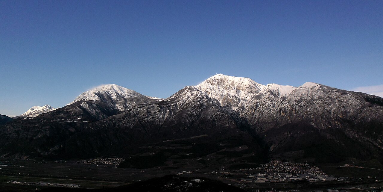
Monte Bondone is a mapped downhill ski area in IT. Forecasts cover three real lift-station locations from approximately 1184 to 2087 metres. Elevations are terrain-model estimates.
Data: OpenSkiData / OpenSkiMap, OpenStreetMap contributors (ODbL), Skimap.org, Who's On First, Mapterhorn.
Monte Bondone - Middle lift station
ECMWF · Εκτέλεση μοντέλου: Αναμενόμενη επόμενη ενημέρωση:
Ημέρα Ώρα (UTC) Θερμ. (°C) Υγρασία (%) Άνεμος (km/h) Άνεμος (κόμβοι) Άνεμος (Bft) Διεύθυνση Υετός (mm) Νέο χιόνι (cm) Πίεση (hPa) Σημείο παγοποίησης (m) Συνθήκες | Τετάρτη, 04/11 06:00 1.4 89 3 2 1B E — — 1024 1863 Overcast 98% cloud 09:00 1.4 87 5 3 1B E 0.02 0 1025 1880 Cloudy 62% cloud 12:00 2.2 83 5 3 1B SE 0.03 0 1025 1997 Overcast 85% cloud 15:00 2.7 82 4 2 1B SE 0.06 0 1024 2095 Overcast 88% cloud 18:00 2.5 84 2 1 1B SE 0.01 0 1026 2062 Cloudy 67% cloud 21:00 2.6 79 2 1 1B E 0.01 0 1028 2144 Partly cloudy 22% cloud Πέμπτη, 05/11 00:00 2 81 1 0 0B E 0 0 1029 2102 Cloudy 55% cloud 03:00 1.9 80 3 2 1B N 0 0 1029 2134 Cloudy 59% cloud 06:00 1.6 84 1 1 1B N 0 0 1030 2145 Overcast 87% cloud 09:00 1.8 77 1 0 0B SE 0 0 1030 2240 Partly cloudy 45% cloud 12:00 3.3 65 3 2 1B S 0 0 1028 2506 Clear 5% cloud 15:00 4.3 62 1 1 1B S 0 0 1026 2725 Clear 2% cloud 18:00 4.1 64 1 1 1B NE 0 0 1027 2757 Clear 2% cloud 21:00 3.7 70 0 0 0B NE 0 0 1027 2778 Clear 17% cloud Παρασκευή, 06/11 00:00 3.4 72 1 0 0B NW 0 0 1027 2732 Partly cloudy 33% cloud 03:00 3.4 68 3 1 1B N 0 0 1025 2830 Cloudy 69% cloud 06:00 3.5 64 3 1 1B NE 0 0 1025 2863 Overcast 85% cloud 09:00 4.1 61 2 1 1B E 0 0 1025 2782 Cloudy 64% cloud 12:00 5.1 61 4 2 1B S 0 0 1022 2700 Cloudy 77% cloud 15:00 5.1 66 5 3 1B S 0 0 1021 2627 Overcast 97% cloud 18:00 4.1 75 6 3 1B SE 0.18 0 1021 2468 Overcast 82% cloud 21:00 3.5 78 5 3 1B SE 0.24 0 1022 2292 Overcast 99% cloud Σάββατο, 07/11 00:00 2.7 73 2 1 1B E 0.56 0 1022 2142 Overcast 100% cloud 03:00 1.6 85 5 3 1B E 1.5 0 1022 1935 Overcast 100% cloud 06:00 1 88 6 3 2B NE 3.9 1.5 1023 1835 Overcast 99% cloud 09:00 1.4 85 7 4 2B NE 0.08 0 1024 1891 Overcast 100% cloud 12:00 1.6 82 5 2 1B E 0.07 0 1023 1915 Overcast 100% cloud 15:00 1.7 81 4 2 1B SE 0.02 0 1023 1916 Overcast 96% cloud 18:00 1.5 81 2 1 1B SE 0.01 0 1024 1893 Overcast 86% cloud 21:00 1.1 88 4 2 1B S 0.08 0 1025 1822 Overcast 97% cloud Κυριακή, 08/11 00:00 0.6 90 3 2 1B SE 0.96 0.3 1025 1742 Overcast 100% cloud 03:00 0.3 89 3 2 1B S 0.91 0.3 1025 1685 Overcast 100% cloud 06:00 0.3 89 4 2 1B S 0.18 0 1025 1685 Overcast 99% cloud 09:00 0.4 93 6 3 2B S 0.02 0 1026 1718 Overcast 96% cloud 12:00 1.1 89 7 4 2B SW 0.08 0 1025 1847 Cloudy 54% cloud 15:00 1.6 81 7 4 2B SW 0 0 1024 1968 Partly cloudy 45% cloud 18:00 1.7 85 3 2 1B SW 0.01 0 1025 2014 Cloudy 61% cloud 21:00 1.6 78 5 2 1B SW 0 0 1026 2041 Partly cloudy 46% cloud Δευτέρα, 09/11 00:00 1.4 80 5 3 1B SW 0 0 1026 2035 Cloudy 67% cloud 03:00 1 83 7 4 2B SW 0 0 1025 1974 Overcast 96% cloud 06:00 0.8 89 7 4 2B SW 0 0 1026 1953 Overcast 93% cloud 09:00 1.1 85 9 5 2B SW 0 0 1026 2156 Cloudy 68% cloud 12:00 2.4 82 12 6 2B SW 0 0 1024 2456 Overcast 87% cloud 15:00 3.1 87 11 6 2B SW 0 0 1022 2410 Overcast 96% cloud 18:00 2.9 93 15 8 3B SW 0.25 0 1023 2325 Overcast 99% cloud 21:00 3.3 96 16 9 3B SW 0.29 0 1022 2464 Overcast 99% cloud Τρίτη, 10/11 00:00 3.5 97 16 8 3B SW 0.30 0 1021 2552 Overcast 99% cloud 03:00 3.7 98 12 6 2B SW 0.50 0 1019 2675 Overcast 100% cloud 06:00 3.7 99 11 6 2B SW 0.41 0 1019 2721 Overcast 100% cloud |
|---|
Forecast notes
Forecast table times: UTC.
Coordinates: 46.0412412°N, 11.0696366°E · Requested elevation: 1636 m. Model terrain: 843 m. Terrain and 1000/925/850/700 hPa profiles are used for height estimates.
These are altitude estimates, not a simulation of local mountain terrain. Precipitation, cloud and sea-level pressure use horizontal interpolation only.
Precipitation includes rain and snow water equivalent: preceding 3 hours through day 6, then 6 hours (see cell tooltip). Snow (cm) estimates fresh snowfall from precipitation and temperature using the GFS conversion; it is not snow depth on the ground. Freezing (m) uses additional 600/500 hPa temperatures when available and estimates the lowest resolved 0°C crossing above sea level. When all sampled levels are warm, the upper profile limit is shown (see tooltip). < marks an entirely cold sampled profile and its lower height limit. No extrapolation is used.
Source: ECMWF · CC BY 4.0 · Processed by Snow Report.
Monte Bondone - Top lift station
ECMWF · Εκτέλεση μοντέλου: Αναμενόμενη επόμενη ενημέρωση:
Ημέρα Ώρα (UTC) Θερμ. (°C) Υγρασία (%) Άνεμος (km/h) Άνεμος (κόμβοι) Άνεμος (Bft) Διεύθυνση Υετός (mm) Νέο χιόνι (cm) Πίεση (hPa) Σημείο παγοποίησης (m) Συνθήκες | Τετάρτη, 04/11 06:00 -1.4 92 6 3 2B E — — 1024 1864 Overcast 98% cloud 09:00 -1.2 90 9 5 2B E 0.01 0 1025 1878 Cloudy 62% cloud 12:00 -0.6 86 9 5 2B SE 0.02 0 1025 1993 Overcast 84% cloud 15:00 0 81 6 3 2B SE 0.06 0 1024 2094 Overcast 87% cloud 18:00 -0.2 84 5 3 1B S 0.01 0 1026 2061 Cloudy 68% cloud 21:00 0.3 75 4 2 1B S 0.00 0 1027 2145 Clear 18% cloud Πέμπτη, 05/11 00:00 0.1 76 3 1 1B S 0 0 1029 2102 Cloudy 53% cloud 03:00 0.2 75 2 1 1B S 0 0 1029 2134 Cloudy 58% cloud 06:00 0.2 76 4 2 1B SW 0 0 1030 2144 Overcast 91% cloud 09:00 0.4 68 6 3 2B SW 0 0 1030 2235 Partly cloudy 47% cloud 12:00 1.5 60 7 4 2B SW 0 0 1028 2498 Clear 5% cloud 15:00 2.5 60 4 2 1B SW 0 0 1026 2721 Clear 2% cloud 18:00 2.4 61 2 1 1B SW 0 0 1027 2754 Clear 2% cloud 21:00 2.2 65 3 2 1B SW 0 0 1027 2777 Clear 15% cloud Παρασκευή, 06/11 00:00 2 67 3 2 1B SW 0 0 1027 2729 Partly cloudy 32% cloud 03:00 2.1 63 2 1 1B S 0 0 1025 2825 Cloudy 73% cloud 06:00 2.2 59 4 2 1B S 0 0 1025 2863 Overcast 89% cloud 09:00 2.5 59 7 4 2B S 0 0 1025 2777 Cloudy 67% cloud 12:00 2.9 65 10 6 2B S 0 0 1022 2694 Overcast 80% cloud 15:00 2.7 69 11 6 2B S 0 0 1021 2623 Overcast 98% cloud 18:00 1.8 74 12 7 2B SE 0.19 0 1021 2463 Overcast 83% cloud 21:00 1.1 76 14 8 3B SE 0.26 0.1 1022 2288 Overcast 99% cloud Σάββατο, 07/11 00:00 0.3 79 13 7 3B SE 0.59 0.2 1022 2139 Overcast 100% cloud 03:00 -0.9 89 13 7 3B SE 1.5 0.5 1022 1928 Overcast 100% cloud 06:00 -1.3 90 6 3 2B SE 3.9 1.5 1023 1833 Overcast 99% cloud 09:00 -1.1 89 7 4 2B E 0.06 0 1024 1890 Overcast 100% cloud 12:00 -1 86 5 3 1B SE 0.05 0 1023 1915 Overcast 100% cloud 15:00 -1.1 85 5 3 1B SE 0.01 0 1023 1916 Overcast 97% cloud 18:00 -1.2 85 5 3 1B S 0.01 0 1024 1891 Overcast 86% cloud 21:00 -1.6 92 6 3 1B S 0.09 0 1025 1819 Overcast 97% cloud Κυριακή, 08/11 00:00 -2 93 7 4 2B S 1.1 0.3 1025 1738 Overcast 100% cloud 03:00 -2.2 91 6 3 1B SW 0.93 0.3 1025 1684 Overcast 100% cloud 06:00 -2.3 90 6 3 2B SW 0.14 0 1025 1684 Overcast 99% cloud 09:00 -2.1 90 8 4 2B SW 0.01 0 1026 1717 Overcast 97% cloud 12:00 -1.3 83 9 5 2B SW 0.09 0 1025 1845 Cloudy 53% cloud 15:00 -0.6 73 10 5 2B SW 0 0 1024 1968 Partly cloudy 45% cloud 18:00 -0.3 73 9 5 2B W 0.01 0 1025 2020 Cloudy 62% cloud 21:00 -0.2 68 8 4 2B W 0 0 1026 2047 Partly cloudy 46% cloud Δευτέρα, 09/11 00:00 -0.2 69 10 6 2B W 0 0 1026 2038 Cloudy 67% cloud 03:00 -0.3 75 12 7 2B W 0 0 1025 1978 Overcast 97% cloud 06:00 -0.3 83 13 7 3B W 0 0 1026 1955 Overcast 94% cloud 09:00 0.2 77 15 8 3B SW 0 0 1026 2163 Cloudy 68% cloud 12:00 1.1 75 21 11 4B SW 0 0 1024 2462 Overcast 86% cloud 15:00 1.3 88 23 12 4B W 0 0 1022 2408 Overcast 97% cloud 18:00 1 95 25 14 4B SW 0.28 0.1 1023 2323 Overcast 99% cloud 21:00 1.5 95 28 15 4B SW 0.31 0 1022 2468 Overcast 99% cloud Τρίτη, 10/11 00:00 1.8 97 29 16 5B SW 0.31 0 1021 2555 Overcast 99% cloud 03:00 2.1 98 26 14 4B W 0.53 0 1019 2674 Overcast 100% cloud 06:00 2.2 99 25 13 4B SW 0.44 0 1019 2724 Overcast 100% cloud |
|---|
Forecast notes
Forecast table times: UTC.
Coordinates: 46.0269684°N, 11.0587172°E · Requested elevation: 2087 m. Model terrain: 817 m. Terrain and 1000/925/850/700 hPa profiles are used for height estimates.
These are altitude estimates, not a simulation of local mountain terrain. Precipitation, cloud and sea-level pressure use horizontal interpolation only.
Precipitation includes rain and snow water equivalent: preceding 3 hours through day 6, then 6 hours (see cell tooltip). Snow (cm) estimates fresh snowfall from precipitation and temperature using the GFS conversion; it is not snow depth on the ground. Freezing (m) uses additional 600/500 hPa temperatures when available and estimates the lowest resolved 0°C crossing above sea level. When all sampled levels are warm, the upper profile limit is shown (see tooltip). < marks an entirely cold sampled profile and its lower height limit. No extrapolation is used.