Wettervorhersagen für Skigebiete weltweit

Farbskala Temperatur · Wind · Regen · Schnee
Jede Farbe beginnt beim angegebenen Wert. Die Windfarben stimmen in allen drei Einheiten überein. Trockene Zellen bleiben neutral. Die Farben beschreiben die Werte und sind keine amtlichen Wetterwarnungen.
Madarao Kogen Mountain Resort - Low lift station
ECMWF · Modelllauf: Nächste Aktualisierung erwartet:
Tag Uhrzeit (UTC) Temp. (°C) Luftfeuchtigkeit (%) Wind (km/h) Wind (Knoten) Wind (Bft) Richtung Niederschlag (mm) Neuschnee (cm) Luftdruck (hPa) Nullgradgrenze (m) Wetterlage | Mittwoch, 04/11 06:00 11.9 59 8 5 2B S — — 1025 3146 Overcast 94% cloud  09:00 10.1 73 14 7 3B S 0.01 0 1025 3152 Overcast 98% cloud 12:00 9.2 86 18 10 3B S 1.0 0 1025 3145 Overcast 100% cloud 15:00 9.1 89 13 7 3B S 3.1 0 1024 3130 Overcast 100% cloud 18:00 9.3 90 15 8 3B S 4.2 0 1021 3120 Overcast 100% cloud 21:00 9.9 88 13 7 3B S 1.3 0 1019 3111 Overcast 97% cloud Donnerstag, 05/11 00:00 12.7 78 15 8 3B S 0.08 0 1016 3098 Overcast 96% cloud 03:00 15.1 68 10 6 2B S 0 0 1012 3071 Overcast 80% cloud 06:00 14.7 73 3 1 1B S 0.04 0 1010 3050 Cloudy 55% cloud  09:00 11.8 88 0 0 0B NE 0.04 0 1009 3041 Overcast 88% cloud 12:00 11.2 89 7 4 2B S 1.1 0 1007 3028 Cloudy 59% cloud 15:00 11 83 7 4 2B SW 0.44 0 1005 3011 Cloudy 61% cloud 18:00 10.3 88 6 3 1B SW 1.3 0 1005 2997 Cloudy 67% cloud 21:00 9.8 93 10 5 2B NW 4.5 0 1007 2878 Overcast 99% cloud Freitag, 06/11 00:00 11.1 94 11 6 2B NW 1.6 0 1009 2740 Cloudy 73% cloud 03:00 13 70 12 7 2B W 2.4 0 1008 2798 Cloudy 67% cloud 06:00 13.1 60 13 7 3B W 0.93 0 1008 2789 Partly cloudy 43% cloud  09:00 9.8 72 14 8 3B W 0 0 1011 2575 Partly cloudy 35% cloud 12:00 7.2 86 13 7 3B NW 0.15 0 1014 2202 Partly cloudy 50% cloud 15:00 5.2 96 14 7 3B NW 2.6 0 1017 1762 Overcast 94% cloud 18:00 3.5 97 13 7 3B NW 3.3 0 1018 1460 Overcast 98% cloud 21:00 3.2 93 13 7 3B W 2.1 0 1019 1464 Overcast 89% cloud Samstag, 07/11 00:00 3.4 94 15 8 3B NW 2.5 0 1022 1363 Overcast 99% cloud 03:00 3.6 84 17 9 3B NW 2.4 0 1023 1353 Cloudy 66% cloud 06:00 3.1 84 17 9 3B NW 2.1 0 1025 1290 Cloudy 71% cloud 09:00 1.6 92 15 8 3B NW 1.5 0 1027 1151 Cloudy 75% cloud 12:00 1.3 89 14 7 3B NW 0.52 0 1029 1095 Cloudy 57% cloud 15:00 0.8 87 13 7 3B NW 0.28 0.1 1031 1063 Cloudy 72% cloud 18:00 1.1 88 11 6 2B NW 0.40 0.1 1031 1081 Cloudy 73% cloud 21:00 1.4 89 10 6 2B NW 0.22 0 1032 1103 Overcast 90% cloud Sonntag, 08/11 00:00 3.4 78 11 6 2B NW 0.14 0 1033 1284 Overcast 86% cloud 03:00 4.7 70 14 7 3B N 0.18 0 1033 1371 Overcast 90% cloud 06:00 4 72 13 7 3B N 0.10 0 1032 1350 Overcast 93% cloud 09:00 3.1 74 8 4 2B N 0 0 1033 1366 Overcast 99% cloud 12:00 2.3 78 3 2 1B NW 0 0 1033 1402 Overcast 84% cloud 15:00 2.4 75 4 2 1B W 0 0 1031 1485 Overcast 99% cloud 18:00 2.7 79 5 3 1B NW 0.15 0 1030 1480 Overcast 99% cloud 21:00 3 88 5 3 1B W 0.58 0 1029 1764 Overcast 94% cloud Montag, 09/11 00:00 6.1 74 7 4 2B SW 0.16 0 1027 2085 Cloudy 52% cloud 03:00 9.1 61 5 3 1B NW 0 0 1023 2140 Cloudy 51% cloud 06:00 7.1 75 11 6 2B N 0 0 1023 1987 Overcast 86% cloud 09:00 5.2 89 7 4 2B NW 0.70 0 1024 1891 Overcast 89% cloud 12:00 3.9 97 14 8 3B N 6.3 0 1026 1515 Overcast 98% cloud 15:00 2.3 98 16 9 3B N 2.9 0 1026 1253 Overcast 95% cloud 18:00 1.2 96 15 8 3B N 1.6 0 1027 1083 Overcast 85% cloud 21:00 0.9 94 13 7 3B NW 0.28 0.1 1027 1037 Cloudy 77% cloud Dienstag, 10/11 00:00 1.6 90 14 7 3B N 1.1 0 1028 1112 Overcast 88% cloud 03:00 1.9 88 13 7 3B N 1.8 0 1027 1129 Overcast 88% cloud 06:00 1.7 84 10 5 2B N 0.72 0 1028 1120 Overcast 90% cloud |
|---|
Forecast notes
Forecast table times: UTC.
Coordinates: 36.851423°N, 138.2848564°E · Requested elevation: 918 m. Model terrain: 585 m. Terrain and 1000/925/850/700 hPa profiles are used for height estimates.
These are altitude estimates, not a simulation of local mountain terrain. Precipitation, cloud and sea-level pressure use horizontal interpolation only.
Precipitation includes rain and snow water equivalent: preceding 3 hours through day 6, then 6 hours (see cell tooltip). Snow (cm) estimates fresh snowfall from precipitation and temperature using the GFS conversion; it is not snow depth on the ground. Freezing (m) uses additional 600/500 hPa temperatures when available and estimates the lowest resolved 0°C crossing above sea level. When all sampled levels are warm, the upper profile limit is shown (see tooltip). < marks an entirely cold sampled profile and its lower height limit. No extrapolation is used.
Source: ECMWF · CC BY 4.0 · Processed by Snow Report.
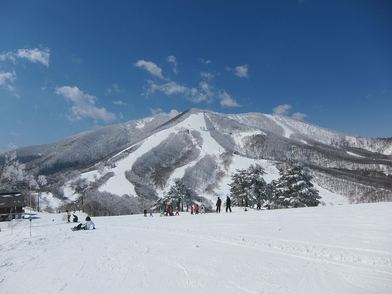
Madarao Kogen Mountain Resort is a downhill ski area in Nagano Prefecture, Japan. Mapped terrain includes easy, intermediate, advanced routes. Its mapped lift network extends from approximately 918 to 1339 metres above sea level.
Data: OpenSkiData / OpenSkiMap, OpenStreetMap contributors (ODbL), Skimap.org, Who's On First, Mapterhorn.
Madarao Kogen Mountain Resort - Base lift station
ECMWF · Modelllauf: Nächste Aktualisierung erwartet:
Tag Uhrzeit (UTC) Temp. (°C) Luftfeuchtigkeit (%) Wind (km/h) Wind (Knoten) Wind (Bft) Richtung Niederschlag (mm) Neuschnee (cm) Luftdruck (hPa) Nullgradgrenze (m) Wetterlage | Mittwoch, 04/11 06:00 11.9 59 8 5 2B S — — 1025 3146 Overcast 94% cloud 09:00 10.1 73 14 7 3B S 0.01 0 1025 3152 Overcast 98% cloud 12:00 9.1 86 18 10 3B S 1.0 0 1025 3145 Overcast 100% cloud 15:00 9 89 13 7 3B S 3.1 0 1024 3130 Overcast 100% cloud 18:00 9.3 90 15 8 3B S 4.2 0 1021 3120 Overcast 100% cloud 21:00 9.9 88 13 7 3B S 1.3 0 1019 3111 Overcast 97% cloud Donnerstag, 05/11 00:00 12.7 78 15 8 3B S 0.08 0 1016 3098 Overcast 96% cloud 03:00 15.1 68 10 6 2B S 0 0 1012 3071 Overcast 80% cloud 06:00 14.7 73 3 1 1B S 0.04 0 1010 3050 Cloudy 55% cloud 09:00 11.8 88 0 0 0B NE 0.04 0 1009 3041 Overcast 88% cloud 12:00 11.2 89 7 4 2B S 1.1 0 1007 3028 Cloudy 59% cloud 15:00 10.9 83 7 4 2B SW 0.44 0 1005 3011 Cloudy 61% cloud 18:00 10.3 88 6 3 1B SW 1.3 0 1005 2997 Cloudy 67% cloud 21:00 9.8 93 10 5 2B NW 4.4 0 1007 2878 Overcast 99% cloud Freitag, 06/11 00:00 11.1 94 11 6 2B NW 1.6 0 1009 2740 Cloudy 73% cloud 03:00 13 70 12 7 2B W 2.4 0 1008 2799 Cloudy 67% cloud 06:00 13.1 60 13 7 3B W 0.93 0 1008 2789 Partly cloudy 43% cloud 09:00 9.8 72 14 8 3B W 0 0 1011 2575 Partly cloudy 35% cloud 12:00 7.2 86 13 7 3B NW 0.15 0 1014 2202 Partly cloudy 50% cloud 15:00 5.2 96 14 7 3B NW 2.6 0 1017 1763 Overcast 94% cloud 18:00 3.5 97 13 7 3B NW 3.3 0 1018 1461 Overcast 98% cloud 21:00 3.2 93 13 7 3B W 2.1 0 1019 1465 Overcast 89% cloud Samstag, 07/11 00:00 3.3 94 15 8 3B NW 2.5 0 1022 1364 Overcast 99% cloud 03:00 3.6 84 17 9 3B NW 2.4 0 1023 1354 Cloudy 66% cloud 06:00 3.1 84 17 9 3B NW 2.1 0 1025 1291 Cloudy 71% cloud 09:00 1.6 92 16 8 3B NW 1.5 0 1027 1152 Cloudy 75% cloud 12:00 1.3 89 14 7 3B NW 0.52 0 1029 1096 Cloudy 58% cloud 15:00 0.8 87 13 7 3B NW 0.27 0.1 1031 1064 Cloudy 72% cloud 18:00 1.1 88 11 6 2B NW 0.40 0.1 1031 1082 Cloudy 73% cloud 21:00 1.4 89 10 6 2B NW 0.21 0 1032 1103 Overcast 90% cloud Sonntag, 08/11 00:00 3.3 78 11 6 2B NW 0.14 0 1033 1284 Overcast 86% cloud 03:00 4.7 70 14 7 3B N 0.17 0 1033 1372 Overcast 90% cloud 06:00 4 72 13 7 3B N 0.10 0 1032 1351 Overcast 93% cloud 09:00 3 74 8 4 2B N 0 0 1033 1367 Overcast 99% cloud 12:00 2.3 78 3 2 1B NW 0 0 1033 1403 Overcast 85% cloud 15:00 2.4 75 4 2 1B W 0 0 1031 1487 Overcast 99% cloud 18:00 2.7 79 5 3 1B NW 0.15 0 1030 1481 Overcast 99% cloud 21:00 3 87 5 3 1B W 0.58 0 1029 1765 Overcast 94% cloud Montag, 09/11 00:00 6.1 74 7 4 2B SW 0.16 0 1027 2086 Cloudy 52% cloud 03:00 9.1 61 5 3 1B NW 0 0 1023 2140 Cloudy 51% cloud 06:00 7.1 75 11 6 2B N 0 0 1023 1988 Overcast 86% cloud 09:00 5.2 89 7 4 2B NW 0.70 0 1024 1892 Overcast 89% cloud 12:00 3.9 97 14 8 3B N 6.2 0 1026 1516 Overcast 98% cloud 15:00 2.3 98 16 9 3B N 2.9 0 1026 1253 Overcast 95% cloud 18:00 1.2 96 15 8 3B N 1.6 0 1027 1083 Overcast 85% cloud 21:00 0.9 94 13 7 3B NW 0.28 0.1 1027 1037 Cloudy 77% cloud Dienstag, 10/11 00:00 1.6 90 14 7 3B N 1.1 0 1028 1113 Overcast 88% cloud 03:00 1.9 88 13 7 3B N 1.8 0 1027 1130 Overcast 88% cloud 06:00 1.7 84 10 5 2B N 0.71 0 1028 1121 Overcast 90% cloud |
|---|
Forecast notes
Forecast table times: UTC.
Coordinates: 36.8504078°N, 138.284779°E · Requested elevation: 921 m. Model terrain: 586 m. Terrain and 1000/925/850/700 hPa profiles are used for height estimates.
These are altitude estimates, not a simulation of local mountain terrain. Precipitation, cloud and sea-level pressure use horizontal interpolation only.
Precipitation includes rain and snow water equivalent: preceding 3 hours through day 6, then 6 hours (see cell tooltip). Snow (cm) estimates fresh snowfall from precipitation and temperature using the GFS conversion; it is not snow depth on the ground. Freezing (m) uses additional 600/500 hPa temperatures when available and estimates the lowest resolved 0°C crossing above sea level. When all sampled levels are warm, the upper profile limit is shown (see tooltip). < marks an entirely cold sampled profile and its lower height limit. No extrapolation is used.
Source: ECMWF · CC BY 4.0 · Processed by Snow Report.
Madarao Kogen Mountain Resort - Top lift station
ECMWF · Modelllauf: Nächste Aktualisierung erwartet:
Tag Uhrzeit (UTC) Temp. (°C) Luftfeuchtigkeit (%) Wind (km/h) Wind (Knoten) Wind (Bft) Richtung Niederschlag (mm) Neuschnee (cm) Luftdruck (hPa) Nullgradgrenze (m) Wetterlage | Mittwoch, 04/11 06:00 8.5 68 19 10 3B S — — 1025 3146 Overcast 94% cloud 09:00 8.4 76 24 13 4B S 0.01 0 1025 3152 Overcast 98% cloud 12:00 7.9 82 30 16 5B S 1.1 0 1025 3145 Overcast 100% cloud 15:00 8 84 24 13 4B S 3.1 0 1024 3130 Overcast 100% cloud 18:00 8.5 84 27 15 4B S 4.1 0 1021 3120 Overcast 100% cloud 21:00 9.7 80 25 13 4B S 1.2 0 1019 3111 Overcast 96% cloud Donnerstag, 05/11 00:00 11.3 73 25 13 4B S 0.08 0 1017 3098 Overcast 96% cloud 03:00 12.2 69 18 10 3B S 0 0 1012 3071 Overcast 80% cloud 06:00 12.1 76 9 5 2B S 0.04 0 1009 3050 Cloudy 55% cloud 09:00 10.5 87 3 2 1B SE 0.04 0 1009 3041 Overcast 88% cloud 12:00 10.5 84 17 9 3B S 1.1 0 1007 3028 Cloudy 58% cloud 15:00 10.8 75 15 8 3B SW 0.46 0 1005 3011 Cloudy 61% cloud 18:00 9.4 87 12 6 2B SW 1.3 0 1005 2997 Cloudy 67% cloud 21:00 8.6 95 22 12 4B NW 4.3 0 1007 2879 Overcast 99% cloud Freitag, 06/11 00:00 8.2 94 21 12 4B NW 1.6 0 1009 2744 Cloudy 74% cloud 03:00 9.1 76 23 12 4B W 2.6 0 1008 2805 Cloudy 70% cloud 06:00 9.5 65 26 14 4B W 1.0 0 1008 2795 Partly cloudy 44% cloud 09:00 7.7 70 27 15 4B W 0 0 1011 2578 Partly cloudy 36% cloud 12:00 5.4 82 24 13 4B W 0.15 0 1014 2209 Partly cloudy 49% cloud 15:00 2.6 94 22 12 4B NW 2.5 0 1017 1772 Overcast 93% cloud 18:00 0.8 94 23 12 4B NW 3.1 1.3 1018 1471 Overcast 98% cloud 21:00 0.8 89 25 13 4B W 2.2 0.6 1019 1477 Overcast 89% cloud Samstag, 07/11 00:00 0.2 96 28 15 4B W 2.5 0.7 1022 1374 Overcast 99% cloud 03:00 0.2 84 33 18 5B W 2.3 0.7 1023 1361 Cloudy 64% cloud 06:00 -0.4 89 32 17 5B NW 2.0 0.6 1025 1298 Cloudy 70% cloud 09:00 -1.3 93 30 16 5B NW 1.5 0.4 1027 1157 Cloudy 74% cloud 12:00 -1.7 90 25 13 4B NW 0.52 0.2 1029 1104 Cloudy 58% cloud 15:00 -1.5 85 22 12 4B NW 0.25 0.1 1030 1074 Cloudy 72% cloud 18:00 -1.7 92 22 12 4B NW 0.37 0.1 1031 1090 Cloudy 72% cloud 21:00 -1.8 95 20 11 4B NW 0.19 0 1032 1107 Overcast 89% cloud Sonntag, 08/11 00:00 -0.5 86 17 9 3B NW 0.12 0 1033 1290 Overcast 86% cloud 03:00 0.4 82 18 10 3B N 0.15 0 1033 1376 Overcast 89% cloud 06:00 0.1 82 17 9 3B N 0.09 0 1032 1357 Overcast 93% cloud 09:00 0.3 79 11 6 2B N 0 0 1033 1378 Overcast 99% cloud 12:00 0.4 80 3 2 1B NW 0 0 1033 1417 Overcast 85% cloud 15:00 0.7 79 4 2 1B SW 0 0 1031 1503 Overcast 99% cloud 18:00 0.7 82 5 3 1B NW 0.15 0 1030 1495 Overcast 99% cloud 21:00 1.6 85 8 5 2B SW 0.55 0 1029 1773 Overcast 93% cloud Montag, 09/11 00:00 4 72 14 7 3B SW 0.16 0 1027 2090 Cloudy 53% cloud 03:00 5.3 68 10 5 2B W 0 0 1023 2146 Cloudy 51% cloud 06:00 4 83 14 7 3B NW 0 0 1023 2000 Overcast 86% cloud 09:00 3.2 87 13 7 3B NW 0.71 0 1024 1902 Overcast 88% cloud 12:00 1.2 97 23 13 4B N 6.0 0 1025 1523 Overcast 98% cloud 15:00 -0.6 96 26 14 4B N 2.8 0.8 1026 1258 Overcast 95% cloud 18:00 -1.9 95 26 14 4B N 1.5 0.4 1027 1087 Overcast 84% cloud 21:00 -2.3 96 25 13 4B NW 0.26 0.1 1027 1039 Cloudy 76% cloud Dienstag, 10/11 00:00 -1.9 96 23 12 4B N 0.96 0.3 1028 1120 Overcast 87% cloud 03:00 -1.9 96 18 10 3B N 1.7 0.5 1027 1136 Overcast 87% cloud 06:00 -1.9 92 13 7 3B N 0.68 0.2 1027 1126 Overcast 90% cloud |
|---|
Forecast notes
Forecast table times: UTC.
Coordinates: 36.8413319°N, 138.2753087°E · Requested elevation: 1339 m. Model terrain: 572 m. Terrain and 1000/925/850/700 hPa profiles are used for height estimates.
These are altitude estimates, not a simulation of local mountain terrain. Precipitation, cloud and sea-level pressure use horizontal interpolation only.
Precipitation includes rain and snow water equivalent: preceding 3 hours through day 6, then 6 hours (see cell tooltip). Snow (cm) estimates fresh snowfall from precipitation and temperature using the GFS conversion; it is not snow depth on the ground. Freezing (m) uses additional 600/500 hPa temperatures when available and estimates the lowest resolved 0°C crossing above sea level. When all sampled levels are warm, the upper profile limit is shown (see tooltip). < marks an entirely cold sampled profile and its lower height limit. No extrapolation is used.