全球滑雪场天气预报

颜色说明 温度 · 风 · 降雨 · 降雪
每种颜色从所示数值开始。三种风速单位的颜色相互对应。无降水单元格保持中性色。颜色仅描述显示值,并非官方天气预警。
正在准备预报图表…
时间和数值与详细预报一致。点击数值查看详情,横向滚动查看后续日期。降水量为每时段总水当量,包含降雪;新雪量指每时段新增降雪,并非地面积雪深度。
GFS与ECMWF模式对比。各模式保留各自的预报时间和时长。降水量和降雪量对应各模式自身的时段,模式之间的时段可能不同。
预报数值与模式说明
Les Rousses - Low lift station
ECMWF · 模式起报时间: 预计下次更新:
日期 时间(UTC) 气温(°C) 湿度(%) 风速(km/h) 风速(节) 风力(Bft) 风向 降水(mm) 新雪(cm) 气压(hPa) 零度层(m) 天气状况 | 星期三, 04/11 06:00 0.5 89 10 5 2B NE — — 1021 2048 Partly cloudy 42% cloud  09:00 4.9 72 9 5 2B NE 0 0 1021 2083 Partly cloudy 27% cloud 12:00 7.4 62 6 3 1B E 0 0 1020 2141 Overcast 90% cloud  15:00 6.3 74 4 2 1B E 0 0 1020 2196 Overcast 93% cloud 18:00 3 83 5 3 1B E 0 0 1021 2315 Partly cloudy 21% cloud 21:00 2 85 4 2 1B E 0 0 1022 2399 Partly cloudy 27% cloud 星期四, 05/11 00:00 2.2 82 6 3 2B E 0 0 1021 2482 Cloudy 73% cloud  03:00 2.4 77 5 3 1B E 0 0 1021 2575 Partly cloudy 38% cloud 06:00 2.9 77 5 2 1B E 0 0 1022 2587 Clear 12% cloud  09:00 7.8 61 4 2 1B SE 0 0 1022 2599 Clear 6% cloud 12:00 11.1 54 1 0 0B SE 0 0 1022 2639 Partly cloudy 38% cloud 15:00 10.2 70 3 2 1B NE 0 0 1021 2669 Clear 11% cloud 18:00 6.3 72 6 3 2B NE 0 0 1021 2704 Partly cloudy 22% cloud 21:00 4.4 79 1 0 0B NE 0 0 1022 2651 Partly cloudy 48% cloud 星期五, 06/11 00:00 3.2 88 1 1 1B NE 0 0 1022 2614 Overcast 92% cloud 03:00 3.2 91 2 1 1B N 0.11 0 1022 2468 Overcast 96% cloud 06:00 2.8 92 2 1 1B N 0.10 0 1023 2155 Overcast 99% cloud 09:00 4.2 97 3 1 1B NE 2.7 0 1024 1920 Overcast 100% cloud 12:00 4.8 97 2 1 1B N 3.0 0 1023 1890 Overcast 100% cloud 15:00 4.9 98 3 2 1B N 0.78 0 1023 1913 Overcast 100% cloud 18:00 4.2 99 3 2 1B N 0.34 0 1023 1813 Overcast 100% cloud 21:00 4.1 99 3 1 1B N 0.50 0 1024 1812 Overcast 100% cloud 星期六, 07/11 00:00 4 97 1 0 0B N 0.37 0 1024 1792 Overcast 100% cloud 03:00 3.5 98 0 0 0B NW 0.27 0 1023 1760 Overcast 100% cloud 06:00 3.5 98 1 0 0B W 0.26 0 1023 1760 Overcast 100% cloud 09:00 5.1 93 1 0 0B NW 0.06 0 1023 1793 Cloudy 73% cloud 12:00 6.3 86 2 1 1B N 0.36 0 1022 1874 Overcast 93% cloud 15:00 5.4 93 2 1 1B N 0.67 0 1022 1858 Cloudy 76% cloud 18:00 4 97 2 1 1B E 0.17 0 1023 1867 Cloudy 75% cloud 21:00 2.3 95 3 2 1B SE 0 0 1023 1973 Cloudy 79% cloud 星期日, 08/11 00:00 1.5 95 3 2 1B S 0 0 1023 1940 Cloudy 77% cloud 03:00 1.5 96 5 2 1B S 0 0 1023 1934 Overcast 86% cloud 06:00 1.8 93 4 2 1B S 0 0 1023 2006 Overcast 88% cloud 09:00 5 88 7 4 2B S 0 0 1024 2108 Cloudy 52% cloud 12:00 7.9 63 13 7 3B S 0 0 1022 2221 Clear 10% cloud 15:00 8 69 8 5 2B S 0 0 1020 2418 Partly cloudy 30% cloud 18:00 6.4 75 8 4 2B S 0.11 0 1020 2474 Overcast 99% cloud 21:00 6.3 86 12 6 2B S 0.69 0 1020 2515 Overcast 99% cloud 星期一, 09/11 00:00 7 84 15 8 3B S 0.31 0 1019 2599 Overcast 100% cloud 03:00 7.2 83 15 8 3B SW 0 0 1018 2607 Overcast 91% cloud 06:00 8 84 16 9 3B S 0.41 0 1017 2692 Overcast 100% cloud 09:00 10.8 76 19 10 3B SW 0.22 0 1016 2776 Overcast 93% cloud 12:00 12 70 20 11 4B S 0 0 1015 2824 Overcast 99% cloud 15:00 11.7 71 20 11 4B SW 0 0 1014 2886 Overcast 100% cloud 18:00 10.7 79 18 10 3B SW 0.15 0 1014 2978 Overcast 98% cloud 21:00 10.7 76 18 10 3B SW 0.01 0 1013 3064 Overcast 94% cloud 星期二, 10/11 00:00 10.5 73 17 9 3B SW 0 0 1012 3058 Overcast 87% cloud 03:00 11.3 69 14 8 3B S 0 0 1009 3039 Overcast 99% cloud 06:00 9.3 90 16 9 3B S 1.9 0 1009 3027 Overcast 100% cloud |
|---|
Forecast notes
Forecast table times: UTC.
Coordinates: 46.5332256°N, 6.1357137°E · Requested elevation: 1060 m. Model terrain: 1004 m. Terrain and 1000/925/850/700 hPa profiles are used for height estimates.
These are altitude estimates, not a simulation of local mountain terrain. Precipitation, cloud and sea-level pressure use horizontal interpolation only.
Precipitation includes rain and snow water equivalent: preceding 3 hours through day 6, then 6 hours (see cell tooltip). Snow (cm) estimates fresh snowfall from precipitation and temperature using the GFS conversion; it is not snow depth on the ground. Freezing (m) uses additional 600/500 hPa temperatures when available and estimates the lowest resolved 0°C crossing above sea level. When all sampled levels are warm, the upper profile limit is shown (see tooltip). < marks an entirely cold sampled profile and its lower height limit. No extrapolation is used.
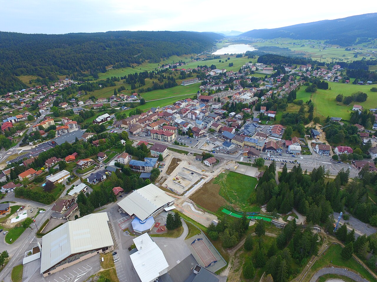
Les Rousses is a downhill ski area in Vaud, Switzerland. Mapped terrain includes beginner, easy, intermediate, advanced routes. Its mapped lift network extends from approximately 1060 to 1663 metres above sea level. Cross-country skiing is also mapped within the area.
Data: OpenSkiData / OpenSkiMap, OpenStreetMap contributors (ODbL), Skimap.org, Who's On First, Mapterhorn.
正在准备预报图表…
时间和数值与详细预报一致。点击数值查看详情,横向滚动查看后续日期。降水量为每时段总水当量,包含降雪;新雪量指每时段新增降雪,并非地面积雪深度。
GFS与ECMWF模式对比。各模式保留各自的预报时间和时长。降水量和降雪量对应各模式自身的时段,模式之间的时段可能不同。
预报数值与模式说明
Les Rousses - Base lift station
ECMWF · 模式起报时间: 预计下次更新:
日期 时间(UTC) 气温(°C) 湿度(%) 风速(km/h) 风速(节) 风力(Bft) 风向 降水(mm) 新雪(cm) 气压(hPa) 零度层(m) 天气状况 | 星期三, 04/11 06:00 1.1 78 12 6 2B NE — — 1021 1036 Partly cloudy 39% cloud 09:00 4.9 67 10 5 2B NE 0 0 1021 2086 Partly cloudy 24% cloud 12:00 6.9 62 5 3 1B E 0 0 1020 2140 Overcast 95% cloud 15:00 6 74 4 2 1B NE 0 0 1020 2197 Overcast 91% cloud 18:00 3.8 72 6 3 2B E 0 0 1021 2324 Partly cloudy 24% cloud 21:00 2.7 75 4 2 1B E 0 0 1022 2399 Clear 14% cloud 星期四, 05/11 00:00 3 71 7 4 2B E 0 0 1021 2485 Cloudy 74% cloud 03:00 3 68 6 3 2B E 0 0 1021 2566 Partly cloudy 49% cloud 06:00 3.5 70 5 3 1B E 0.02 0 1022 2562 Clear 8% cloud 09:00 7.7 57 4 2 1B SE 0 0 1022 2581 Clear 5% cloud 12:00 10.6 50 2 1 1B SE 0 0 1022 2631 Partly cloudy 40% cloud 15:00 9.9 66 4 2 1B NE 0 0 1021 2655 Clear 9% cloud 18:00 6.6 67 8 4 2B NE 0 0 1021 2687 Partly cloudy 30% cloud 21:00 4.7 78 3 2 1B NE 0 0 1023 2622 Cloudy 58% cloud 星期五, 06/11 00:00 3.6 87 3 2 1B NE 0 0 1022 2593 Overcast 95% cloud 03:00 3.4 88 3 2 1B N 0.20 0 1022 2444 Overcast 97% cloud 06:00 2.8 91 4 2 1B N 0.29 0 1023 2113 Overcast 100% cloud 09:00 3.6 97 6 3 2B NE 4.1 0 1024 1890 Overcast 100% cloud 12:00 4 98 5 3 1B NE 2.6 0 1023 1877 Overcast 100% cloud 15:00 4.2 97 7 4 2B N 0.63 0 1023 1912 Overcast 100% cloud 18:00 3.7 98 7 4 2B N 0.33 0 1023 1812 Overcast 100% cloud 21:00 3.5 98 6 3 1B N 0.60 0 1024 1810 Overcast 100% cloud 星期六, 07/11 00:00 3.4 98 3 2 1B N 0.48 0 1024 1784 Overcast 100% cloud 03:00 3.1 98 2 1 1B N 0.20 0 1023 1757 Overcast 100% cloud 06:00 3 97 1 1 1B N 0.25 0 1023 1754 Overcast 99% cloud 09:00 4.2 94 2 1 1B N 0.08 0 1024 1783 Cloudy 74% cloud 12:00 5.4 86 2 1 1B N 0.26 0 1022 1873 Overcast 92% cloud 15:00 4.7 93 2 1 1B NE 0.54 0 1022 1868 Cloudy 79% cloud 18:00 3.4 96 4 2 1B SE 0.12 0 1023 1864 Cloudy 69% cloud 21:00 2 93 6 3 2B S 0 0 1023 1988 Overcast 94% cloud 星期日, 08/11 00:00 1.1 92 7 4 2B S 0 0 1023 1944 Overcast 89% cloud 03:00 1.1 94 10 5 2B S 0 0 1023 1949 Overcast 94% cloud 06:00 1.4 89 9 5 2B S 0 0 1023 2028 Overcast 95% cloud 09:00 4.5 82 13 7 3B S 0 0 1024 2129 Partly cloudy 37% cloud 12:00 7 64 18 10 3B S 0 0 1022 2229 Clear 12% cloud 15:00 7.4 70 14 8 3B S 0 0 1020 2424 Partly cloudy 29% cloud 18:00 6.4 75 16 8 3B S 0.17 0 1020 2488 Overcast 95% cloud 21:00 6.3 84 21 11 4B S 0.57 0 1020 2539 Overcast 99% cloud 星期一, 09/11 00:00 6.9 84 25 13 4B S 0.12 0 1019 2600 Overcast 99% cloud 03:00 7.2 84 25 14 4B S 0 0 1018 2604 Overcast 92% cloud 06:00 8 83 26 14 4B S 0.21 0 1017 2691 Overcast 99% cloud 09:00 10.2 76 28 15 4B S 0.14 0 1016 2766 Overcast 96% cloud 12:00 10.9 74 30 16 5B S 0 0 1016 2821 Overcast 100% cloud 15:00 10.9 74 29 15 4B SW 0 0 1014 2885 Overcast 100% cloud 18:00 10.4 78 28 15 4B S 0.10 0 1014 2997 Overcast 98% cloud 21:00 10.5 75 29 16 4B S 0 0 1013 3065 Overcast 94% cloud 星期二, 10/11 00:00 10.5 71 28 15 4B S 0 0 1012 3059 Overcast 87% cloud 03:00 11.2 69 25 13 4B S 0 0 1009 3039 Overcast 99% cloud 06:00 9.6 86 29 16 5B S 1.6 0 1009 3028 Overcast 100% cloud |
|---|
Forecast notes
Forecast table times: UTC.
Coordinates: 46.4561269°N, 6.0549357°E · Requested elevation: 1163 m. Model terrain: 999 m. Terrain and 1000/925/850/700 hPa profiles are used for height estimates.
These are altitude estimates, not a simulation of local mountain terrain. Precipitation, cloud and sea-level pressure use horizontal interpolation only.
Precipitation includes rain and snow water equivalent: preceding 3 hours through day 6, then 6 hours (see cell tooltip). Snow (cm) estimates fresh snowfall from precipitation and temperature using the GFS conversion; it is not snow depth on the ground. Freezing (m) uses additional 600/500 hPa temperatures when available and estimates the lowest resolved 0°C crossing above sea level. When all sampled levels are warm, the upper profile limit is shown (see tooltip). < marks an entirely cold sampled profile and its lower height limit. No extrapolation is used.
正在准备预报图表…
时间和数值与详细预报一致。点击数值查看详情,横向滚动查看后续日期。降水量为每时段总水当量,包含降雪;新雪量指每时段新增降雪,并非地面积雪深度。
GFS与ECMWF模式对比。各模式保留各自的预报时间和时长。降水量和降雪量对应各模式自身的时段,模式之间的时段可能不同。
预报数值与模式说明
Les Rousses - Top lift station
ECMWF · 模式起报时间: 预计下次更新:
日期 时间(UTC) 气温(°C) 湿度(%) 风速(km/h) 风速(节) 风力(Bft) 风向 降水(mm) 新雪(cm) 气压(hPa) 零度层(m) 天气状况 | 星期三, 04/11 06:00 2.6 56 20 11 4B NE — — 1021 2051 Partly cloudy 46% cloud 09:00 2.7 55 17 9 3B NE 0 0 1021 2078 Partly cloudy 33% cloud 12:00 3.1 59 8 4 2B E 0 0 1021 2143 Overcast 97% cloud 15:00 3.6 65 6 3 2B E 0 0 1020 2200 Overcast 89% cloud 18:00 4.6 45 9 5 2B E 0 0 1021 2323 Partly cloudy 25% cloud 21:00 4.7 52 7 4 2B SE 0 0 1022 2393 Clear 18% cloud 星期四, 05/11 00:00 5.5 45 11 6 2B E 0 0 1022 2482 Cloudy 72% cloud 03:00 5.6 44 11 6 2B E 0 0 1021 2563 Cloudy 55% cloud 06:00 5.6 48 9 5 2B SE 0.02 0 1022 2565 Clear 10% cloud 09:00 6.7 43 10 6 2B S 0 0 1023 2582 Clear 8% cloud 12:00 7.1 45 6 3 2B S 0 0 1022 2634 Partly cloudy 42% cloud 15:00 7.3 56 8 4 2B NE 0 0 1021 2661 Clear 10% cloud 18:00 7.4 45 18 10 3B NE 0 0 1021 2696 Partly cloudy 32% cloud 21:00 5.8 58 11 6 2B NE 0 0 1023 2627 Cloudy 58% cloud 星期五, 06/11 00:00 4.4 69 7 4 2B NE 0 0 1022 2594 Overcast 94% cloud 03:00 3.3 74 5 3 1B NE 0.25 0 1022 2458 Overcast 97% cloud 06:00 1.7 85 8 4 2B NE 0.31 0 1023 2121 Overcast 100% cloud 09:00 0.8 99 10 6 2B NE 3.9 1.6 1024 1880 Overcast 100% cloud 12:00 0.9 98 9 5 2B NE 2.7 0.8 1023 1878 Overcast 100% cloud 15:00 1.2 96 13 7 3B N 0.58 0 1023 1912 Overcast 100% cloud 18:00 0.8 99 15 8 3B N 0.37 0.1 1023 1817 Overcast 100% cloud 21:00 0.7 98 13 7 3B N 0.76 0.2 1024 1807 Overcast 100% cloud 星期六, 07/11 00:00 0.6 99 8 5 2B N 0.50 0.1 1024 1783 Overcast 100% cloud 03:00 0.5 98 5 3 1B N 0.26 0.1 1023 1757 Overcast 100% cloud 06:00 0.5 96 3 2 1B N 0.27 0.1 1023 1758 Overcast 98% cloud 09:00 0.7 94 4 2 1B NE 0.07 0 1023 1798 Cloudy 70% cloud 12:00 1.2 92 3 1 1B NE 0.26 0 1022 1881 Overcast 85% cloud 15:00 1.1 92 2 1 1B E 0.55 0.2 1022 1876 Cloudy 68% cloud 18:00 1.1 87 7 4 2B SE 0.12 0 1023 1874 Cloudy 66% cloud 21:00 1.7 79 14 8 3B S 0 0 1023 1982 Overcast 88% cloud 星期日, 08/11 00:00 1.5 77 23 12 4B SW 0 0 1024 1953 Overcast 83% cloud 03:00 1.4 81 28 15 4B SW 0 0 1023 1949 Overcast 90% cloud 06:00 1.9 69 28 15 4B SW 0 0 1023 2030 Overcast 92% cloud 09:00 2.4 55 32 18 5B SW 0 0 1024 2125 Partly cloudy 45% cloud 12:00 2.9 65 37 20 5B SW 0 0 1022 2234 Clear 13% cloud 15:00 4.3 76 34 19 5B SW 0 0 1020 2423 Partly cloudy 32% cloud 18:00 5 74 39 21 6B SW 0.17 0 1020 2489 Overcast 90% cloud 21:00 4.9 82 47 26 6B SW 0.70 0 1020 2529 Overcast 99% cloud 星期一, 09/11 00:00 5.5 87 54 29 7B SW 0.12 0 1019 2596 Overcast 99% cloud 03:00 5.9 86 56 30 7B SW 0 0 1018 2606 Overcast 91% cloud 06:00 6.5 84 55 30 7B SW 0.26 0 1017 2691 Overcast 99% cloud 09:00 7.2 78 55 30 7B SW 0.15 0 1016 2777 Overcast 95% cloud 12:00 7.3 82 58 31 7B SW 0 0 1016 2826 Overcast 100% cloud 15:00 7.8 78 55 30 7B SW 0 0 1014 2887 Overcast 100% cloud 18:00 8.3 78 54 29 7B SW 0.09 0 1014 2991 Overcast 98% cloud 21:00 9.1 72 56 30 7B SW 0 0 1013 3066 Overcast 94% cloud 星期二, 10/11 00:00 9.5 68 55 30 7B SW 0 0 1012 3059 Overcast 89% cloud 03:00 9.7 69 49 26 6B S 0 0 1009 3040 Overcast 99% cloud 06:00 8.9 79 56 30 7B S 1.6 0 1009 3029 Overcast 100% cloud |
|---|
Forecast notes
Forecast table times: UTC.
Coordinates: 46.4258188°N, 6.0992777°E · Requested elevation: 1663 m. Model terrain: 919 m. Terrain and 1000/925/850/700 hPa profiles are used for height estimates.
These are altitude estimates, not a simulation of local mountain terrain. Precipitation, cloud and sea-level pressure use horizontal interpolation only.
Precipitation includes rain and snow water equivalent: preceding 3 hours through day 6, then 6 hours (see cell tooltip). Snow (cm) estimates fresh snowfall from precipitation and temperature using the GFS conversion; it is not snow depth on the ground. Freezing (m) uses additional 600/500 hPa temperatures when available and estimates the lowest resolved 0°C crossing above sea level. When all sampled levels are warm, the upper profile limit is shown (see tooltip). < marks an entirely cold sampled profile and its lower height limit. No extrapolation is used.