Προγνώσεις για χιονοδρομικά σε όλο τον κόσμο

Περισσότερα
Χρωματική κλίμακα Θερμοκρασία · Άνεμος · Βροχή · Χιόνι
Κάθε χρώμα ξεκινά από την τιμή που αναγράφεται. Τα χρώματα ανέμου αντιστοιχούν και στις τρεις μονάδες. Οι τιμές χωρίς υετό παραμένουν ουδέτερες. Τα χρώματα περιγράφουν τις τιμές και δεν αποτελούν επίσημες προειδοποιήσεις.
Προετοιμασία γραφημάτων…
Οι ώρες και οι τιμές αντιστοιχούν στην αναλυτική πρόγνωση. Πατήστε μια τιμή για λεπτομέρειες και μετακινήστε οριζόντια τα γραφήματα για επόμενες ημέρες. Ο υετός είναι το συνολικό ισοδύναμο νερού ανά διάστημα, μαζί με το χιόνι. Η χιονόπτωση αφορά νέο χιόνι ανά διάστημα, όχι το ύψος του χιονιού στο έδαφος.
Σύγκριση GFS και ECMWF. Κάθε μοντέλο διατηρεί τις δικές του ώρες και διάρκεια πρόγνωσης. Ο υετός και το νέο χιόνι αφορούν τα διαστήματα κάθε μοντέλου, τα οποία μπορεί να διαφέρουν.
Τιμές πρόγνωσης και σημειώσεις μοντέλων
Les Rousses - Χαμηλός σταθμός
ECMWF · Εκτέλεση μοντέλου: Αναμενόμενη επόμενη ενημέρωση:
Ημέρα Ώρα (UTC) Θερμ. (°C) Υγρασία (%) Άνεμος (km/h) Άνεμος (κόμβοι) Άνεμος (Bft) Διεύθυνση Υετός (mm) Νέο χιόνι (cm) Πίεση (hPa) Σημείο παγοποίησης (m) Συνθήκες | Τετάρτη, 04/11 06:00 0.5 89 10 5 2B NE — — 1021 2048 Partly cloudy 42% cloud  09:00 4.9 72 9 5 2B NE 0 0 1021 2083 Partly cloudy 27% cloud 12:00 7.4 62 6 3 1B E 0 0 1020 2141 Overcast 90% cloud  15:00 6.3 74 4 2 1B E 0 0 1020 2196 Overcast 93% cloud 18:00 3 83 5 3 1B E 0 0 1021 2315 Partly cloudy 21% cloud 21:00 2 85 4 2 1B E 0 0 1022 2399 Partly cloudy 27% cloud Πέμπτη, 05/11 00:00 2.2 82 6 3 2B E 0 0 1021 2482 Cloudy 73% cloud  03:00 2.4 77 5 3 1B E 0 0 1021 2575 Partly cloudy 38% cloud 06:00 2.9 77 5 2 1B E 0 0 1022 2587 Clear 12% cloud  09:00 7.8 61 4 2 1B SE 0 0 1022 2599 Clear 6% cloud 12:00 11.1 54 1 0 0B SE 0 0 1022 2639 Partly cloudy 38% cloud 15:00 10.2 70 3 2 1B NE 0 0 1021 2669 Clear 11% cloud 18:00 6.3 72 6 3 2B NE 0 0 1021 2704 Partly cloudy 22% cloud 21:00 4.4 79 1 0 0B NE 0 0 1022 2651 Partly cloudy 48% cloud Παρασκευή, 06/11 00:00 3.2 88 1 1 1B NE 0 0 1022 2614 Overcast 92% cloud 03:00 3.2 91 2 1 1B N 0.11 0 1022 2468 Overcast 96% cloud 06:00 2.8 92 2 1 1B N 0.10 0 1023 2155 Overcast 99% cloud 09:00 4.2 97 3 1 1B NE 2.7 0 1024 1920 Overcast 100% cloud 12:00 4.8 97 2 1 1B N 3.0 0 1023 1890 Overcast 100% cloud 15:00 4.9 98 3 2 1B N 0.78 0 1023 1913 Overcast 100% cloud 18:00 4.2 99 3 2 1B N 0.34 0 1023 1813 Overcast 100% cloud 21:00 4.1 99 3 1 1B N 0.50 0 1024 1812 Overcast 100% cloud Σάββατο, 07/11 00:00 4 97 1 0 0B N 0.37 0 1024 1792 Overcast 100% cloud 03:00 3.5 98 0 0 0B NW 0.27 0 1023 1760 Overcast 100% cloud 06:00 3.5 98 1 0 0B W 0.26 0 1023 1760 Overcast 100% cloud 09:00 5.1 93 1 0 0B NW 0.06 0 1023 1793 Cloudy 73% cloud 12:00 6.3 86 2 1 1B N 0.36 0 1022 1874 Overcast 93% cloud 15:00 5.4 93 2 1 1B N 0.67 0 1022 1858 Cloudy 76% cloud 18:00 4 97 2 1 1B E 0.17 0 1023 1867 Cloudy 75% cloud 21:00 2.3 95 3 2 1B SE 0 0 1023 1973 Cloudy 79% cloud Κυριακή, 08/11 00:00 1.5 95 3 2 1B S 0 0 1023 1940 Cloudy 77% cloud 03:00 1.5 96 5 2 1B S 0 0 1023 1934 Overcast 86% cloud 06:00 1.8 93 4 2 1B S 0 0 1023 2006 Overcast 88% cloud 09:00 5 88 7 4 2B S 0 0 1024 2108 Cloudy 52% cloud 12:00 7.9 63 13 7 3B S 0 0 1022 2221 Clear 10% cloud 15:00 8 69 8 5 2B S 0 0 1020 2418 Partly cloudy 30% cloud 18:00 6.4 75 8 4 2B S 0.11 0 1020 2474 Overcast 99% cloud 21:00 6.3 86 12 6 2B S 0.69 0 1020 2515 Overcast 99% cloud Δευτέρα, 09/11 00:00 7 84 15 8 3B S 0.31 0 1019 2599 Overcast 100% cloud 03:00 7.2 83 15 8 3B SW 0 0 1018 2607 Overcast 91% cloud 06:00 8 84 16 9 3B S 0.41 0 1017 2692 Overcast 100% cloud 09:00 10.8 76 19 10 3B SW 0.22 0 1016 2776 Overcast 93% cloud 12:00 12 70 20 11 4B S 0 0 1015 2824 Overcast 99% cloud 15:00 11.7 71 20 11 4B SW 0 0 1014 2886 Overcast 100% cloud 18:00 10.7 79 18 10 3B SW 0.15 0 1014 2978 Overcast 98% cloud 21:00 10.7 76 18 10 3B SW 0.01 0 1013 3064 Overcast 94% cloud Τρίτη, 10/11 00:00 10.5 73 17 9 3B SW 0 0 1012 3058 Overcast 87% cloud 03:00 11.3 69 14 8 3B S 0 0 1009 3039 Overcast 99% cloud 06:00 9.3 90 16 9 3B S 1.9 0 1009 3027 Overcast 100% cloud |
|---|
Forecast notes
Forecast table times: UTC.
Coordinates: 46.5332256°N, 6.1357137°E · Requested elevation: 1060 m. Model terrain: 1004 m. Terrain and 1000/925/850/700 hPa profiles are used for height estimates.
These are altitude estimates, not a simulation of local mountain terrain. Precipitation, cloud and sea-level pressure use horizontal interpolation only.
Precipitation includes rain and snow water equivalent: preceding 3 hours through day 6, then 6 hours (see cell tooltip). Snow (cm) estimates fresh snowfall from precipitation and temperature using the GFS conversion; it is not snow depth on the ground. Freezing (m) uses additional 600/500 hPa temperatures when available and estimates the lowest resolved 0°C crossing above sea level. When all sampled levels are warm, the upper profile limit is shown (see tooltip). < marks an entirely cold sampled profile and its lower height limit. No extrapolation is used.
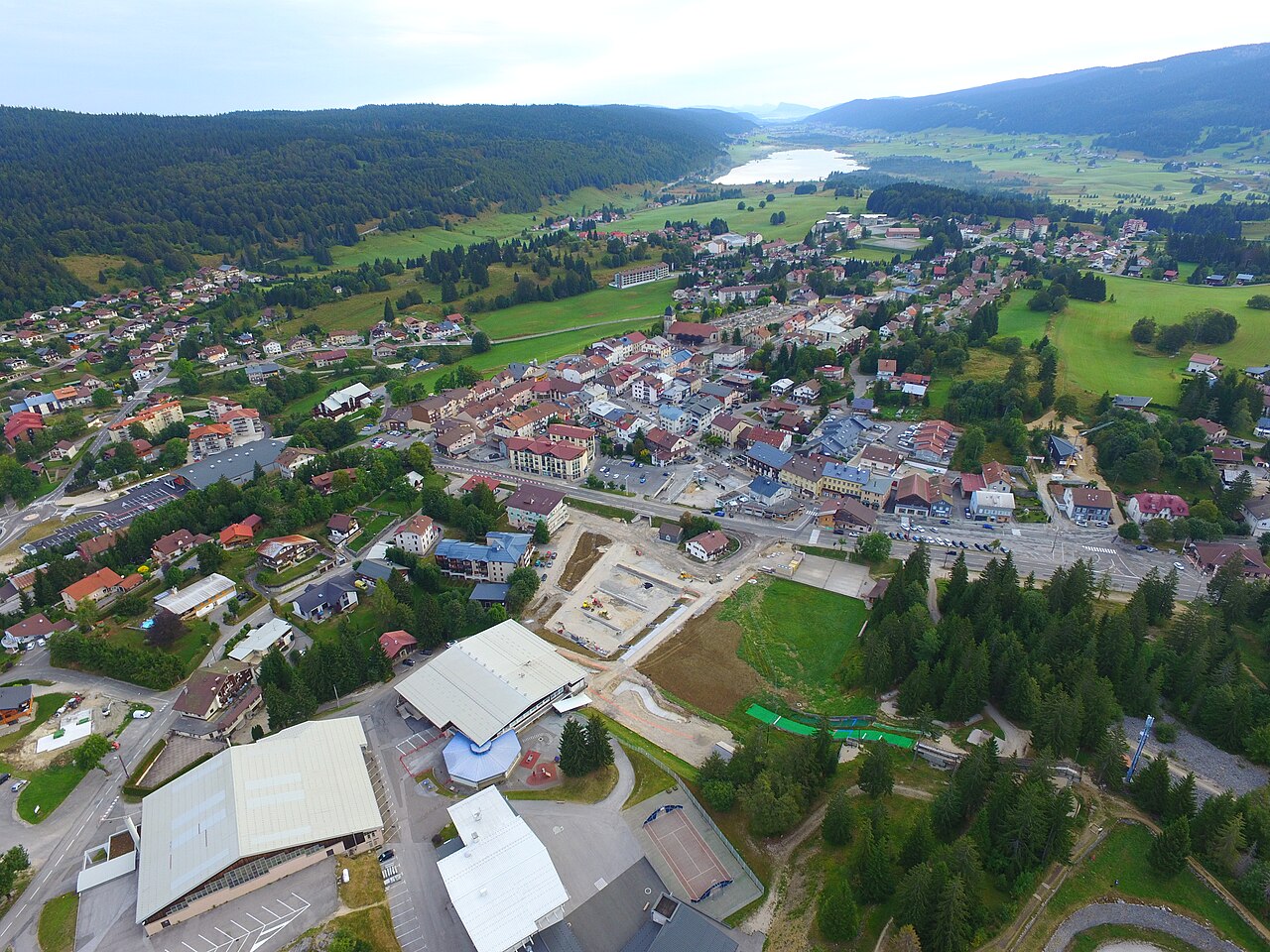
Les Rousses is a downhill ski area in Vaud, Switzerland. Mapped terrain includes beginner, easy, intermediate, advanced routes. Its mapped lift network extends from approximately 1060 to 1663 metres above sea level. Cross-country skiing is also mapped within the area.
Data: OpenSkiData / OpenSkiMap, OpenStreetMap contributors (ODbL), Skimap.org, Who's On First, Mapterhorn.
Προετοιμασία γραφημάτων…
Οι ώρες και οι τιμές αντιστοιχούν στην αναλυτική πρόγνωση. Πατήστε μια τιμή για λεπτομέρειες και μετακινήστε οριζόντια τα γραφήματα για επόμενες ημέρες. Ο υετός είναι το συνολικό ισοδύναμο νερού ανά διάστημα, μαζί με το χιόνι. Η χιονόπτωση αφορά νέο χιόνι ανά διάστημα, όχι το ύψος του χιονιού στο έδαφος.
Σύγκριση GFS και ECMWF. Κάθε μοντέλο διατηρεί τις δικές του ώρες και διάρκεια πρόγνωσης. Ο υετός και το νέο χιόνι αφορούν τα διαστήματα κάθε μοντέλου, τα οποία μπορεί να διαφέρουν.
Τιμές πρόγνωσης και σημειώσεις μοντέλων
Les Rousses - Σταθμός βάσης
ECMWF · Εκτέλεση μοντέλου: Αναμενόμενη επόμενη ενημέρωση:
Ημέρα Ώρα (UTC) Θερμ. (°C) Υγρασία (%) Άνεμος (km/h) Άνεμος (κόμβοι) Άνεμος (Bft) Διεύθυνση Υετός (mm) Νέο χιόνι (cm) Πίεση (hPa) Σημείο παγοποίησης (m) Συνθήκες | Τετάρτη, 04/11 06:00 1.1 78 12 6 2B NE — — 1021 1036 Partly cloudy 39% cloud 09:00 4.9 67 10 5 2B NE 0 0 1021 2086 Partly cloudy 24% cloud 12:00 6.9 62 5 3 1B E 0 0 1020 2140 Overcast 95% cloud 15:00 6 74 4 2 1B NE 0 0 1020 2197 Overcast 91% cloud 18:00 3.8 72 6 3 2B E 0 0 1021 2324 Partly cloudy 24% cloud 21:00 2.7 75 4 2 1B E 0 0 1022 2399 Clear 14% cloud Πέμπτη, 05/11 00:00 3 71 7 4 2B E 0 0 1021 2485 Cloudy 74% cloud 03:00 3 68 6 3 2B E 0 0 1021 2566 Partly cloudy 49% cloud 06:00 3.5 70 5 3 1B E 0.02 0 1022 2562 Clear 8% cloud 09:00 7.7 57 4 2 1B SE 0 0 1022 2581 Clear 5% cloud 12:00 10.6 50 2 1 1B SE 0 0 1022 2631 Partly cloudy 40% cloud 15:00 9.9 66 4 2 1B NE 0 0 1021 2655 Clear 9% cloud 18:00 6.6 67 8 4 2B NE 0 0 1021 2687 Partly cloudy 30% cloud 21:00 4.7 78 3 2 1B NE 0 0 1023 2622 Cloudy 58% cloud Παρασκευή, 06/11 00:00 3.6 87 3 2 1B NE 0 0 1022 2593 Overcast 95% cloud 03:00 3.4 88 3 2 1B N 0.20 0 1022 2444 Overcast 97% cloud 06:00 2.8 91 4 2 1B N 0.29 0 1023 2113 Overcast 100% cloud 09:00 3.6 97 6 3 2B NE 4.1 0 1024 1890 Overcast 100% cloud 12:00 4 98 5 3 1B NE 2.6 0 1023 1877 Overcast 100% cloud 15:00 4.2 97 7 4 2B N 0.63 0 1023 1912 Overcast 100% cloud 18:00 3.7 98 7 4 2B N 0.33 0 1023 1812 Overcast 100% cloud 21:00 3.5 98 6 3 1B N 0.60 0 1024 1810 Overcast 100% cloud Σάββατο, 07/11 00:00 3.4 98 3 2 1B N 0.48 0 1024 1784 Overcast 100% cloud 03:00 3.1 98 2 1 1B N 0.20 0 1023 1757 Overcast 100% cloud 06:00 3 97 1 1 1B N 0.25 0 1023 1754 Overcast 99% cloud 09:00 4.2 94 2 1 1B N 0.08 0 1024 1783 Cloudy 74% cloud 12:00 5.4 86 2 1 1B N 0.26 0 1022 1873 Overcast 92% cloud 15:00 4.7 93 2 1 1B NE 0.54 0 1022 1868 Cloudy 79% cloud 18:00 3.4 96 4 2 1B SE 0.12 0 1023 1864 Cloudy 69% cloud 21:00 2 93 6 3 2B S 0 0 1023 1988 Overcast 94% cloud Κυριακή, 08/11 00:00 1.1 92 7 4 2B S 0 0 1023 1944 Overcast 89% cloud 03:00 1.1 94 10 5 2B S 0 0 1023 1949 Overcast 94% cloud 06:00 1.4 89 9 5 2B S 0 0 1023 2028 Overcast 95% cloud 09:00 4.5 82 13 7 3B S 0 0 1024 2129 Partly cloudy 37% cloud 12:00 7 64 18 10 3B S 0 0 1022 2229 Clear 12% cloud 15:00 7.4 70 14 8 3B S 0 0 1020 2424 Partly cloudy 29% cloud 18:00 6.4 75 16 8 3B S 0.17 0 1020 2488 Overcast 95% cloud 21:00 6.3 84 21 11 4B S 0.57 0 1020 2539 Overcast 99% cloud Δευτέρα, 09/11 00:00 6.9 84 25 13 4B S 0.12 0 1019 2600 Overcast 99% cloud 03:00 7.2 84 25 14 4B S 0 0 1018 2604 Overcast 92% cloud 06:00 8 83 26 14 4B S 0.21 0 1017 2691 Overcast 99% cloud 09:00 10.2 76 28 15 4B S 0.14 0 1016 2766 Overcast 96% cloud 12:00 10.9 74 30 16 5B S 0 0 1016 2821 Overcast 100% cloud 15:00 10.9 74 29 15 4B SW 0 0 1014 2885 Overcast 100% cloud 18:00 10.4 78 28 15 4B S 0.10 0 1014 2997 Overcast 98% cloud 21:00 10.5 75 29 16 4B S 0 0 1013 3065 Overcast 94% cloud Τρίτη, 10/11 00:00 10.5 71 28 15 4B S 0 0 1012 3059 Overcast 87% cloud 03:00 11.2 69 25 13 4B S 0 0 1009 3039 Overcast 99% cloud 06:00 9.6 86 29 16 5B S 1.6 0 1009 3028 Overcast 100% cloud |
|---|
Forecast notes
Forecast table times: UTC.
Coordinates: 46.4561269°N, 6.0549357°E · Requested elevation: 1163 m. Model terrain: 999 m. Terrain and 1000/925/850/700 hPa profiles are used for height estimates.
These are altitude estimates, not a simulation of local mountain terrain. Precipitation, cloud and sea-level pressure use horizontal interpolation only.
Precipitation includes rain and snow water equivalent: preceding 3 hours through day 6, then 6 hours (see cell tooltip). Snow (cm) estimates fresh snowfall from precipitation and temperature using the GFS conversion; it is not snow depth on the ground. Freezing (m) uses additional 600/500 hPa temperatures when available and estimates the lowest resolved 0°C crossing above sea level. When all sampled levels are warm, the upper profile limit is shown (see tooltip). < marks an entirely cold sampled profile and its lower height limit. No extrapolation is used.
Προετοιμασία γραφημάτων…
Οι ώρες και οι τιμές αντιστοιχούν στην αναλυτική πρόγνωση. Πατήστε μια τιμή για λεπτομέρειες και μετακινήστε οριζόντια τα γραφήματα για επόμενες ημέρες. Ο υετός είναι το συνολικό ισοδύναμο νερού ανά διάστημα, μαζί με το χιόνι. Η χιονόπτωση αφορά νέο χιόνι ανά διάστημα, όχι το ύψος του χιονιού στο έδαφος.
Σύγκριση GFS και ECMWF. Κάθε μοντέλο διατηρεί τις δικές του ώρες και διάρκεια πρόγνωσης. Ο υετός και το νέο χιόνι αφορούν τα διαστήματα κάθε μοντέλου, τα οποία μπορεί να διαφέρουν.
Τιμές πρόγνωσης και σημειώσεις μοντέλων
Les Rousses - Άνω σταθμός
ECMWF · Εκτέλεση μοντέλου: Αναμενόμενη επόμενη ενημέρωση:
Ημέρα Ώρα (UTC) Θερμ. (°C) Υγρασία (%) Άνεμος (km/h) Άνεμος (κόμβοι) Άνεμος (Bft) Διεύθυνση Υετός (mm) Νέο χιόνι (cm) Πίεση (hPa) Σημείο παγοποίησης (m) Συνθήκες | Τετάρτη, 04/11 06:00 2.6 56 20 11 4B NE — — 1021 2051 Partly cloudy 46% cloud 09:00 2.7 55 17 9 3B NE 0 0 1021 2078 Partly cloudy 33% cloud 12:00 3.1 59 8 4 2B E 0 0 1021 2143 Overcast 97% cloud 15:00 3.6 65 6 3 2B E 0 0 1020 2200 Overcast 89% cloud 18:00 4.6 45 9 5 2B E 0 0 1021 2323 Partly cloudy 25% cloud 21:00 4.7 52 7 4 2B SE 0 0 1022 2393 Clear 18% cloud Πέμπτη, 05/11 00:00 5.5 45 11 6 2B E 0 0 1022 2482 Cloudy 72% cloud 03:00 5.6 44 11 6 2B E 0 0 1021 2563 Cloudy 55% cloud 06:00 5.6 48 9 5 2B SE 0.02 0 1022 2565 Clear 10% cloud 09:00 6.7 43 10 6 2B S 0 0 1023 2582 Clear 8% cloud 12:00 7.1 45 6 3 2B S 0 0 1022 2634 Partly cloudy 42% cloud 15:00 7.3 56 8 4 2B NE 0 0 1021 2661 Clear 10% cloud 18:00 7.4 45 18 10 3B NE 0 0 1021 2696 Partly cloudy 32% cloud 21:00 5.8 58 11 6 2B NE 0 0 1023 2627 Cloudy 58% cloud Παρασκευή, 06/11 00:00 4.4 69 7 4 2B NE 0 0 1022 2594 Overcast 94% cloud 03:00 3.3 74 5 3 1B NE 0.25 0 1022 2458 Overcast 97% cloud 06:00 1.7 85 8 4 2B NE 0.31 0 1023 2121 Overcast 100% cloud 09:00 0.8 99 10 6 2B NE 3.9 1.6 1024 1880 Overcast 100% cloud 12:00 0.9 98 9 5 2B NE 2.7 0.8 1023 1878 Overcast 100% cloud 15:00 1.2 96 13 7 3B N 0.58 0 1023 1912 Overcast 100% cloud 18:00 0.8 99 15 8 3B N 0.37 0.1 1023 1817 Overcast 100% cloud 21:00 0.7 98 13 7 3B N 0.76 0.2 1024 1807 Overcast 100% cloud Σάββατο, 07/11 00:00 0.6 99 8 5 2B N 0.50 0.1 1024 1783 Overcast 100% cloud 03:00 0.5 98 5 3 1B N 0.26 0.1 1023 1757 Overcast 100% cloud 06:00 0.5 96 3 2 1B N 0.27 0.1 1023 1758 Overcast 98% cloud 09:00 0.7 94 4 2 1B NE 0.07 0 1023 1798 Cloudy 70% cloud 12:00 1.2 92 3 1 1B NE 0.26 0 1022 1881 Overcast 85% cloud 15:00 1.1 92 2 1 1B E 0.55 0.2 1022 1876 Cloudy 68% cloud 18:00 1.1 87 7 4 2B SE 0.12 0 1023 1874 Cloudy 66% cloud 21:00 1.7 79 14 8 3B S 0 0 1023 1982 Overcast 88% cloud Κυριακή, 08/11 00:00 1.5 77 23 12 4B SW 0 0 1024 1953 Overcast 83% cloud 03:00 1.4 81 28 15 4B SW 0 0 1023 1949 Overcast 90% cloud 06:00 1.9 69 28 15 4B SW 0 0 1023 2030 Overcast 92% cloud 09:00 2.4 55 32 18 5B SW 0 0 1024 2125 Partly cloudy 45% cloud 12:00 2.9 65 37 20 5B SW 0 0 1022 2234 Clear 13% cloud 15:00 4.3 76 34 19 5B SW 0 0 1020 2423 Partly cloudy 32% cloud 18:00 5 74 39 21 6B SW 0.17 0 1020 2489 Overcast 90% cloud 21:00 4.9 82 47 26 6B SW 0.70 0 1020 2529 Overcast 99% cloud Δευτέρα, 09/11 00:00 5.5 87 54 29 7B SW 0.12 0 1019 2596 Overcast 99% cloud 03:00 5.9 86 56 30 7B SW 0 0 1018 2606 Overcast 91% cloud 06:00 6.5 84 55 30 7B SW 0.26 0 1017 2691 Overcast 99% cloud 09:00 7.2 78 55 30 7B SW 0.15 0 1016 2777 Overcast 95% cloud 12:00 7.3 82 58 31 7B SW 0 0 1016 2826 Overcast 100% cloud 15:00 7.8 78 55 30 7B SW 0 0 1014 2887 Overcast 100% cloud 18:00 8.3 78 54 29 7B SW 0.09 0 1014 2991 Overcast 98% cloud 21:00 9.1 72 56 30 7B SW 0 0 1013 3066 Overcast 94% cloud Τρίτη, 10/11 00:00 9.5 68 55 30 7B SW 0 0 1012 3059 Overcast 89% cloud 03:00 9.7 69 49 26 6B S 0 0 1009 3040 Overcast 99% cloud 06:00 8.9 79 56 30 7B S 1.6 0 1009 3029 Overcast 100% cloud |
|---|
Forecast notes
Forecast table times: UTC.
Coordinates: 46.4258188°N, 6.0992777°E · Requested elevation: 1663 m. Model terrain: 919 m. Terrain and 1000/925/850/700 hPa profiles are used for height estimates.
These are altitude estimates, not a simulation of local mountain terrain. Precipitation, cloud and sea-level pressure use horizontal interpolation only.
Precipitation includes rain and snow water equivalent: preceding 3 hours through day 6, then 6 hours (see cell tooltip). Snow (cm) estimates fresh snowfall from precipitation and temperature using the GFS conversion; it is not snow depth on the ground. Freezing (m) uses additional 600/500 hPa temperatures when available and estimates the lowest resolved 0°C crossing above sea level. When all sampled levels are warm, the upper profile limit is shown (see tooltip). < marks an entirely cold sampled profile and its lower height limit. No extrapolation is used.