Worldwide Ski Resort Forecasts

Colour guide Temperature · Wind · Rain · Snow
Each colour starts at the value shown. Wind colours match across all three units. Dry cells stay neutral. Colours describe the displayed values, not official weather warnings.
La Croix de Bauzon - Low lift station
ECMWF · Model run: Next update expected:
Day Time (UTC) Temp. (°C) Humidity (%) Wind (km/h) Wind (knots) Wind (Bft) Direction Precip. (mm) Snow (cm) Pressure (hPa) Freezing (m) Conditions | Wednesday, 04/11 06:00 3 73 13 7 3B E — — 1018 1979 Overcast 100% cloud  09:00 3.7 73 12 7 3B E 0.18 0 1020 1892 Overcast 100% cloud 12:00 3.7 83 16 9 3B E 1.2 0 1020 1890 Overcast 100% cloud 15:00 4 85 20 11 3B E 1.1 0 1019 1941 Overcast 100% cloud 18:00 3.5 87 25 13 4B E 3.0 0 1020 1929 Overcast 99% cloud 21:00 3.6 89 25 13 4B SE 0.70 0 1020 1996 Overcast 100% cloud Thursday, 05/11 00:00 4 89 28 15 4B SE 1.2 0 1020 2117 Overcast 99% cloud 03:00 3.2 95 19 10 3B SE 5.4 0 1020 1980 Overcast 99% cloud 06:00 3.8 92 26 14 4B SE 2.9 0 1021 2144 Overcast 94% cloud 09:00 5 95 34 18 5B SE 2.3 0 1022 2250 Overcast 89% cloud 12:00 5.8 95 35 19 5B SE 3.5 0 1022 2362 Overcast 98% cloud 15:00 6.1 97 31 17 5B S 4.9 0 1021 2375 Overcast 100% cloud 18:00 5.7 98 19 10 3B S 5.3 0 1022 2321 Overcast 100% cloud 21:00 4.9 96 11 6 2B SW 9.4 0 1023 2213 Overcast 100% cloud Friday, 06/11 00:00 4.2 98 6 3 2B SW 11.4 0 1022 2098 Overcast 100% cloud 03:00 4.2 88 8 4 2B N 6.2 0 1022 2128 Cloudy 58% cloud  06:00 3.9 86 10 6 2B N 0.19 0 1022 2138 Partly cloudy 22% cloud  09:00 5 86 13 7 3B N 0 0 1023 2052 Clear 18% cloud  12:00 6.5 71 14 7 3B N 0.06 0 1021 2094 Partly cloudy 34% cloud 15:00 6.2 69 15 8 3B N 0.07 0 1021 2105 Partly cloudy 41% cloud 18:00 3.7 83 18 10 3B NW 0.04 0 1023 2082 Clear 18% cloud 21:00 3.4 76 18 10 3B N 0 0 1024 2102 Cloudy 52% cloud Saturday, 07/11 00:00 3.1 75 13 7 3B N 0 0 1024 2105 Cloudy 68% cloud 03:00 2.8 73 11 6 2B N 0 0 1023 2073 Cloudy 68% cloud 06:00 2.3 69 10 6 2B N 0 0 1024 2047 Cloudy 62% cloud 09:00 3.9 63 7 4 2B N 0 0 1024 2056 Clear 16% cloud 12:00 6.1 57 1 0 0B N 0 0 1021 2175 Partly cloudy 29% cloud 15:00 5.8 68 2 1 1B SE 0 0 1021 2270 Cloudy 71% cloud 18:00 3.4 87 4 2 1B S 0 0 1023 2194 Overcast 82% cloud 21:00 3.2 79 8 4 2B S 0 0 1023 2232 Clear 4% cloud Sunday, 08/11 00:00 3 73 14 8 3B S 0 0 1023 2232 Partly cloudy 46% cloud 03:00 3 63 17 9 3B S 0 0 1023 2340 Cloudy 77% cloud 06:00 3.2 90 22 12 4B S 0 0 1023 2339 Cloudy 67% cloud 09:00 4.7 96 25 13 4B S 0.25 0 1024 2395 Overcast 100% cloud 12:00 5 98 34 18 5B S 1.6 0 1022 2644 Overcast 100% cloud 15:00 5.9 98 34 18 5B S 2.4 0 1021 2695 Overcast 100% cloud 18:00 6.2 99 37 20 5B S 2.2 0 1022 2770 Overcast 100% cloud 21:00 6.3 98 40 22 6B S 3.7 0 1021 3092 Overcast 100% cloud Monday, 09/11 00:00 6.4 98 41 22 6B S 3.9 0 1021 3089 Overcast 100% cloud 03:00 6.5 98 43 23 6B S 4.3 0 1019 3080 Overcast 100% cloud 06:00 6.5 98 45 24 6B S 3.9 0 1019 3044 Overcast 100% cloud 09:00 7 98 45 24 6B S 3.4 0 1020 3086 Overcast 100% cloud 12:00 7.7 98 47 26 6B S 3.4 0 1018 3080 Overcast 100% cloud 15:00 8.3 99 48 26 6B S 4.0 0 1016 3072 Overcast 100% cloud 18:00 8.2 98 46 25 6B S 5.5 0 1016 3074 Overcast 100% cloud 21:00 8.2 98 48 26 6B S 6.1 0 1016 3073 Overcast 100% cloud Tuesday, 10/11 00:00 8.1 98 45 25 6B S 7.2 0 1014 3060 Overcast 100% cloud 03:00 8.2 97 45 24 6B S 7.8 0 1012 3040 Overcast 100% cloud 06:00 8.4 97 44 24 6B S 9.8 0 1010 3031 Overcast 100% cloud |
|---|
Forecast notes
Forecast table times: UTC.
Coordinates: 44.6299169°N, 4.0947728°E · Requested elevation: 1259 m. Model terrain: 883 m. Terrain and 1000/925/850/700 hPa profiles are used for height estimates.
These are altitude estimates, not a simulation of local mountain terrain. Precipitation, cloud and sea-level pressure use horizontal interpolation only.
Precipitation includes rain and snow water equivalent: preceding 3 hours through day 6, then 6 hours (see cell tooltip). Snow (cm) estimates fresh snowfall from precipitation and temperature using the GFS conversion; it is not snow depth on the ground. Freezing (m) uses additional 600/500 hPa temperatures when available and estimates the lowest resolved 0°C crossing above sea level. When all sampled levels are warm, the upper profile limit is shown (see tooltip). < marks an entirely cold sampled profile and its lower height limit. No extrapolation is used.
Source: ECMWF · CC BY 4.0 · Processed by Snow Report.
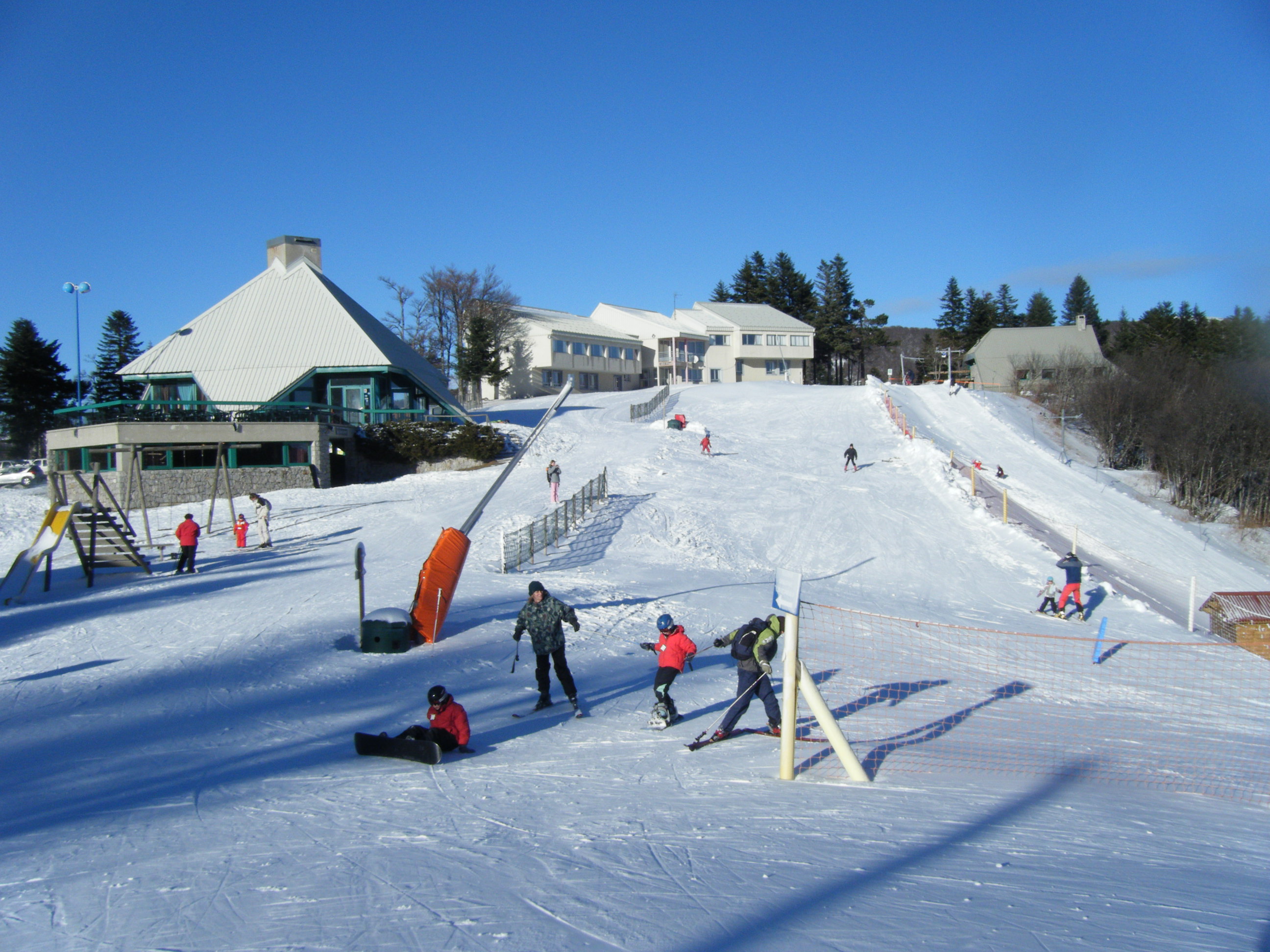
La Croix de Bauzon is a downhill ski area in Ardèche, France. Mapped terrain includes beginner, easy routes. Its mapped lift network extends from approximately 1259 to 1507 metres above sea level. Cross-country skiing is also mapped within the area.
Data: OpenSkiData / OpenSkiMap, OpenStreetMap contributors (ODbL), Skimap.org, Who's On First, Mapterhorn.
La Croix de Bauzon - Base lift station
ECMWF · Model run: Next update expected:
Day Time (UTC) Temp. (°C) Humidity (%) Wind (km/h) Wind (knots) Wind (Bft) Direction Precip. (mm) Snow (cm) Pressure (hPa) Freezing (m) Conditions | Wednesday, 04/11 06:00 3 73 13 7 3B E — — 1018 1979 Overcast 100% cloud 09:00 3.7 73 12 7 3B E 0.18 0 1020 1892 Overcast 100% cloud 12:00 3.7 83 16 9 3B E 1.2 0 1020 1890 Overcast 100% cloud 15:00 4 85 20 11 3B E 1.1 0 1019 1941 Overcast 100% cloud 18:00 3.5 87 25 13 4B E 3.0 0 1020 1929 Overcast 99% cloud 21:00 3.6 89 25 13 4B SE 0.70 0 1020 1996 Overcast 100% cloud Thursday, 05/11 00:00 4 89 28 15 4B SE 1.2 0 1020 2117 Overcast 99% cloud 03:00 3.2 95 19 10 3B SE 5.4 0 1020 1980 Overcast 99% cloud 06:00 3.8 92 26 14 4B SE 2.9 0 1021 2144 Overcast 94% cloud 09:00 5 95 34 18 5B SE 2.3 0 1022 2250 Overcast 89% cloud 12:00 5.8 95 35 19 5B SE 3.5 0 1022 2362 Overcast 98% cloud 15:00 6.1 97 31 17 5B S 4.9 0 1021 2375 Overcast 100% cloud 18:00 5.7 98 19 10 3B S 5.3 0 1022 2321 Overcast 100% cloud 21:00 4.9 96 11 6 2B SW 9.4 0 1023 2213 Overcast 100% cloud Friday, 06/11 00:00 4.2 98 6 3 2B SW 11.4 0 1022 2098 Overcast 100% cloud 03:00 4.2 88 8 4 2B N 6.2 0 1022 2128 Cloudy 58% cloud 06:00 3.9 86 10 6 2B N 0.19 0 1022 2138 Partly cloudy 22% cloud 09:00 5 86 13 7 3B N 0 0 1023 2052 Clear 18% cloud 12:00 6.5 71 14 7 3B N 0.06 0 1021 2094 Partly cloudy 34% cloud 15:00 6.2 69 15 8 3B N 0.07 0 1021 2105 Partly cloudy 41% cloud 18:00 3.7 83 18 10 3B NW 0.04 0 1023 2082 Clear 18% cloud 21:00 3.4 76 18 10 3B N 0 0 1024 2102 Cloudy 52% cloud Saturday, 07/11 00:00 3.1 75 13 7 3B N 0 0 1024 2105 Cloudy 68% cloud 03:00 2.8 73 11 6 2B N 0 0 1023 2073 Cloudy 68% cloud 06:00 2.3 69 10 6 2B N 0 0 1024 2047 Cloudy 62% cloud 09:00 3.9 63 7 4 2B N 0 0 1024 2056 Clear 16% cloud 12:00 6.1 57 1 0 0B N 0 0 1021 2175 Partly cloudy 29% cloud 15:00 5.8 68 2 1 1B SE 0 0 1021 2270 Cloudy 71% cloud 18:00 3.4 87 4 2 1B S 0 0 1023 2194 Overcast 82% cloud 21:00 3.2 79 8 4 2B S 0 0 1023 2232 Clear 4% cloud Sunday, 08/11 00:00 3 73 14 8 3B S 0 0 1023 2232 Partly cloudy 46% cloud 03:00 3 63 17 9 3B S 0 0 1023 2340 Cloudy 77% cloud 06:00 3.2 90 22 12 4B S 0 0 1023 2339 Cloudy 67% cloud 09:00 4.7 96 25 13 4B S 0.25 0 1024 2395 Overcast 100% cloud 12:00 5 98 34 18 5B S 1.6 0 1022 2644 Overcast 100% cloud 15:00 5.9 98 34 18 5B S 2.4 0 1021 2695 Overcast 100% cloud 18:00 6.2 99 37 20 5B S 2.2 0 1022 2770 Overcast 100% cloud 21:00 6.3 98 40 22 6B S 3.7 0 1021 3092 Overcast 100% cloud Monday, 09/11 00:00 6.4 98 41 22 6B S 3.9 0 1021 3089 Overcast 100% cloud 03:00 6.5 98 43 23 6B S 4.3 0 1019 3080 Overcast 100% cloud 06:00 6.5 98 45 24 6B S 3.9 0 1019 3044 Overcast 100% cloud 09:00 7 98 45 24 6B S 3.4 0 1020 3086 Overcast 100% cloud 12:00 7.7 98 47 26 6B S 3.4 0 1018 3080 Overcast 100% cloud 15:00 8.3 99 48 26 6B S 4.0 0 1016 3072 Overcast 100% cloud 18:00 8.2 98 46 25 6B S 5.5 0 1016 3074 Overcast 100% cloud 21:00 8.2 98 48 26 6B S 6.1 0 1016 3073 Overcast 100% cloud Tuesday, 10/11 00:00 8.1 98 45 25 6B S 7.2 0 1014 3060 Overcast 100% cloud 03:00 8.2 97 45 24 6B S 7.8 0 1012 3040 Overcast 100% cloud 06:00 8.4 97 44 24 6B S 9.8 0 1010 3031 Overcast 100% cloud |
|---|
Forecast notes
Forecast table times: UTC.
Coordinates: 44.6299169°N, 4.0947728°E · Requested elevation: 1259 m. Model terrain: 883 m. Terrain and 1000/925/850/700 hPa profiles are used for height estimates.
These are altitude estimates, not a simulation of local mountain terrain. Precipitation, cloud and sea-level pressure use horizontal interpolation only.
Precipitation includes rain and snow water equivalent: preceding 3 hours through day 6, then 6 hours (see cell tooltip). Snow (cm) estimates fresh snowfall from precipitation and temperature using the GFS conversion; it is not snow depth on the ground. Freezing (m) uses additional 600/500 hPa temperatures when available and estimates the lowest resolved 0°C crossing above sea level. When all sampled levels are warm, the upper profile limit is shown (see tooltip). < marks an entirely cold sampled profile and its lower height limit. No extrapolation is used.
Source: ECMWF · CC BY 4.0 · Processed by Snow Report.
La Croix de Bauzon - Top lift station
ECMWF · Model run: Next update expected:
Day Time (UTC) Temp. (°C) Humidity (%) Wind (km/h) Wind (knots) Wind (Bft) Direction Precip. (mm) Snow (cm) Pressure (hPa) Freezing (m) Conditions | Wednesday, 04/11 06:00 3.2 69 21 11 4B E — — 1018 1976 Overcast 100% cloud 09:00 2.4 73 19 10 3B E 0.20 0 1020 1885 Overcast 100% cloud 12:00 2.3 76 28 15 4B E 1.3 0 1020 1885 Overcast 100% cloud 15:00 2.2 80 31 17 5B E 1.1 0 1019 1933 Overcast 100% cloud 18:00 2.4 84 39 21 5B SE 2.9 0 1020 1926 Overcast 100% cloud 21:00 2.6 89 39 21 6B SE 0.66 0 1020 1995 Overcast 100% cloud Thursday, 05/11 00:00 3 89 43 23 6B SE 1.2 0 1020 2110 Overcast 99% cloud 03:00 1.8 96 29 15 4B SE 5.6 0 1020 1975 Overcast 99% cloud 06:00 2.9 92 42 23 6B SE 2.8 0 1021 2142 Overcast 95% cloud 09:00 3.8 95 52 28 7B SE 2.4 0 1022 2247 Overcast 90% cloud 12:00 4.3 95 54 29 7B SE 3.4 0 1022 2357 Overcast 98% cloud 15:00 4.8 97 47 26 6B S 4.9 0 1021 2372 Overcast 100% cloud 18:00 4.5 99 32 17 5B S 5.4 0 1022 2318 Overcast 100% cloud 21:00 3.5 95 17 9 3B S 9.7 0 1023 2210 Overcast 100% cloud Friday, 06/11 00:00 2.8 98 12 6 2B SW 11.4 0 1022 2097 Overcast 100% cloud 03:00 3.4 82 10 6 2B N 6.0 0 1022 2133 Cloudy 54% cloud 06:00 3.8 80 14 8 3B N 0.15 0 1022 2139 Partly cloudy 21% cloud 09:00 3.2 84 17 9 3B N 0 0 1023 2053 Clear 19% cloud 12:00 3.7 80 17 9 3B N 0.06 0 1021 2097 Partly cloudy 34% cloud 15:00 3.8 76 19 10 3B N 0.06 0 1021 2107 Partly cloudy 39% cloud 18:00 2.9 78 23 12 4B NW 0.04 0 1023 2084 Clear 18% cloud 21:00 3 64 24 13 4B N 0 0 1024 2105 Cloudy 52% cloud Saturday, 07/11 00:00 2.7 64 17 9 3B N 0 0 1024 2108 Cloudy 69% cloud 03:00 2.4 60 12 6 2B N 0 0 1024 2075 Cloudy 69% cloud 06:00 2.2 56 12 7 3B N 0 0 1024 2051 Cloudy 63% cloud 09:00 2.4 55 9 5 2B N 0 0 1024 2062 Clear 17% cloud 12:00 3.4 62 2 1 1B NW 0 0 1021 2182 Partly cloudy 31% cloud 15:00 3.6 73 1 1 1B SW 0 0 1021 2275 Cloudy 74% cloud 18:00 2.8 83 6 3 2B S 0 0 1023 2199 Overcast 82% cloud 21:00 3.3 72 12 6 2B S 0 0 1023 2237 Clear 3% cloud Sunday, 08/11 00:00 3.2 61 21 12 4B S 0 0 1023 2233 Partly cloudy 46% cloud 03:00 3.5 45 26 14 4B S 0 0 1023 2341 Cloudy 77% cloud 06:00 3.2 89 33 18 5B S 0 0 1023 2337 Cloudy 69% cloud 09:00 3.8 99 37 20 5B S 0.27 0 1024 2393 Overcast 100% cloud 12:00 4 99 50 27 7B S 1.6 0 1022 2653 Overcast 100% cloud 15:00 5.2 98 51 28 7B S 2.3 0 1021 2703 Overcast 100% cloud 18:00 5.6 99 55 30 7B S 2.1 0 1022 2773 Overcast 100% cloud 21:00 5.6 98 59 32 7B S 3.6 0 1021 3092 Overcast 100% cloud Monday, 09/11 00:00 5.7 98 60 33 7B S 3.9 0 1021 3089 Overcast 100% cloud 03:00 5.9 98 62 34 8B S 4.3 0 1019 3080 Overcast 100% cloud 06:00 5.9 98 64 35 8B S 4.0 0 1019 3040 Overcast 100% cloud 09:00 6.3 98 65 35 8B S 3.5 0 1020 3086 Overcast 100% cloud 12:00 6.8 98 66 36 8B S 3.6 0 1018 3080 Overcast 100% cloud 15:00 7.3 98 65 35 8B S 4.1 0 1016 3072 Overcast 100% cloud 18:00 7.4 98 63 34 8B S 5.6 0 1016 3074 Overcast 100% cloud 21:00 7.4 97 66 36 8B S 6.3 0 1016 3073 Overcast 100% cloud Tuesday, 10/11 00:00 7.3 98 63 34 8B S 7.4 0 1014 3060 Overcast 100% cloud 03:00 7.4 97 61 33 7B S 7.8 0 1012 3040 Overcast 100% cloud 06:00 7.8 97 60 32 7B S 10.0 0 1010 3031 Overcast 100% cloud |
|---|
Forecast notes
Forecast table times: UTC.
Coordinates: 44.6196874°N, 4.0798489°E · Requested elevation: 1507 m. Model terrain: 886 m. Terrain and 1000/925/850/700 hPa profiles are used for height estimates.
These are altitude estimates, not a simulation of local mountain terrain. Precipitation, cloud and sea-level pressure use horizontal interpolation only.
Precipitation includes rain and snow water equivalent: preceding 3 hours through day 6, then 6 hours (see cell tooltip). Snow (cm) estimates fresh snowfall from precipitation and temperature using the GFS conversion; it is not snow depth on the ground. Freezing (m) uses additional 600/500 hPa temperatures when available and estimates the lowest resolved 0°C crossing above sea level. When all sampled levels are warm, the upper profile limit is shown (see tooltip). < marks an entirely cold sampled profile and its lower height limit. No extrapolation is used.