Previsiones para estaciones de esquí de todo el mundo

Guía de colores Temperatura · Viento · Lluvia · Nieve
Cada color comienza en el valor indicado. Los colores del viento coinciden en las tres unidades. Las celdas sin precipitación permanecen neutras. Los colores describen los valores mostrados, no son avisos meteorológicos oficiales.
Kurumayama Kogen SKYPARK - Low lift station
ECMWF · Ejecución del modelo: Próxima actualización prevista:
Día Hora (UTC) Temp. (°C) Humedad (%) Viento (km/h) Viento (nudos) Viento (Bft) Dirección Precip. (mm) Nieve nueva (cm) Presión (hPa) Isoterma de 0 °C (m) Condiciones | Miércoles, 04/11 06:00 6.2 87 18 10 3B SE — — 1027 3152 Overcast 99% cloud  09:00 6.2 91 23 12 4B SE 0.21 0 1027 3156 Overcast 100% cloud 12:00 6.3 91 27 14 4B SE 2.4 0 1027 3151 Overcast 100% cloud 15:00 6.7 92 20 11 4B SE 2.5 0 1024 3140 Overcast 100% cloud 18:00 7.3 92 17 9 3B SE 2.9 0 1022 3130 Overcast 100% cloud 21:00 8.6 85 15 8 3B SE 1.9 0 1020 3119 Overcast 99% cloud Jueves, 05/11 00:00 9.2 86 8 5 2B SE 0 0 1018 3108 Cloudy 70% cloud  03:00 12.6 69 13 7 3B SW 0.06 0 1013 3079 Cloudy 78% cloud 06:00 13.2 59 13 7 3B SW 0 0 1010 3058 Partly cloudy 24% cloud  09:00 8.8 77 11 6 2B SW 0 0 1009 3051 Partly cloudy 39% cloud 12:00 7.9 75 13 7 3B W 0.05 0 1008 3038 Clear 14% cloud  15:00 7.8 76 16 9 3B SW 0.01 0 1006 3021 Partly cloudy 40% cloud 18:00 7.1 86 19 10 3B W 0.46 0 1005 3006 Cloudy 58% cloud 21:00 6.3 94 14 8 3B W 0.56 0 1007 3009 Cloudy 73% cloud Viernes, 06/11 00:00 9.9 81 18 10 3B W 0.32 0 1009 3022 Clear 19% cloud 03:00 12.1 45 25 13 4B W 0.09 0 1008 3020 Clear 10% cloud 06:00 11.2 45 26 14 4B W 0 0 1009 3005 Clear 19% cloud 09:00 6.8 65 19 11 3B W 0 0 1012 2878 Partly cloudy 23% cloud 12:00 4 78 19 10 3B W 0 0 1014 2474 Partly cloudy 22% cloud 15:00 2.7 83 18 10 3B W 0 0 1015 2116 Cloudy 57% cloud 18:00 1.2 84 20 11 4B W 0 0 1017 1795 Partly cloudy 36% cloud 21:00 -0 78 22 12 4B W 0.04 0 1019 1563 Partly cloudy 42% cloud Sábado, 07/11 00:00 1.2 69 25 14 4B W 0.08 0 1021 1757 Partly cloudy 47% cloud 03:00 2.5 55 32 17 5B W 0 0 1020 1902 Partly cloudy 32% cloud 06:00 1.6 58 26 14 4B W 0 0 1023 1811 Partly cloudy 26% cloud 09:00 -0.7 67 14 8 3B W 0 0 1027 1402 Partly cloudy 28% cloud 12:00 -0.7 58 11 6 2B W 0 0 1029 < 1220 Clear 19% cloud 15:00 -0.3 45 9 5 2B NW 0 0 1029 < 1220 Clear 11% cloud 18:00 -0.4 51 12 7 3B N 0 0 1030 < 1220 Clear 10% cloud 21:00 -0.6 58 11 6 2B N 0 0 1032 < 1220 Clear 10% cloud Domingo, 08/11 00:00 0.7 53 8 4 2B NW 0 0 1032 2953 Partly cloudy 41% cloud 03:00 3.1 49 8 5 2B NW 0 0 1029 2759 Partly cloudy 36% cloud 06:00 4 49 9 5 2B NW 0 0 1028 2855 Cloudy 76% cloud 09:00 3.1 60 4 2 1B NW 0 0 1030 2532 Overcast 93% cloud 12:00 2.7 67 8 4 2B SW 0 0 1031 2377 Overcast 94% cloud 15:00 3.8 68 14 7 3B SW 0 0 1029 2422 Overcast 95% cloud 18:00 3.8 68 9 5 2B SW 0 0 1028 2336 Overcast 95% cloud 21:00 3.9 69 10 5 2B SW 0.01 0 1027 2284 Overcast 96% cloud Lunes, 09/11 00:00 4.6 75 14 8 3B SW 0.30 0 1026 2439 Cloudy 78% cloud 03:00 6.4 62 14 8 3B SW 0.07 0 1021 2557 Partly cloudy 42% cloud 06:00 7.4 56 11 6 2B W 0 0 1019 2481 Partly cloudy 44% cloud 09:00 4.6 72 11 6 2B NW 0 0 1022 2246 Partly cloudy 37% cloud 12:00 3.3 77 12 6 2B NW 0.18 0 1023 2085 Partly cloudy 33% cloud 15:00 0.4 88 20 11 4B N 0.15 0 1024 1655 Overcast 90% cloud 18:00 -1.4 87 23 13 4B N 0.02 0 1025 1344 Overcast 81% cloud 21:00 -2.4 87 19 10 3B NW 0 0 1026 < 1220 Cloudy 65% cloud Martes, 10/11 00:00 -1.7 78 17 9 3B NW 0 0 1026 1414 Partly cloudy 21% cloud 03:00 0.3 67 13 7 3B NW 0 0 1024 1644 Clear 19% cloud 06:00 1.4 62 11 6 2B NW 0 0 1023 1837 Clear 4% cloud |
|---|
Forecast notes
Forecast table times: UTC.
Coordinates: 36.1017865°N, 138.2133131°E · Requested elevation: 1569 m. Model terrain: 1218 m. Terrain and 1000/925/850/700 hPa profiles are used for height estimates.
These are altitude estimates, not a simulation of local mountain terrain. Precipitation, cloud and sea-level pressure use horizontal interpolation only.
Precipitation includes rain and snow water equivalent: preceding 3 hours through day 6, then 6 hours (see cell tooltip). Snow (cm) estimates fresh snowfall from precipitation and temperature using the GFS conversion; it is not snow depth on the ground. Freezing (m) uses additional 600/500 hPa temperatures when available and estimates the lowest resolved 0°C crossing above sea level. When all sampled levels are warm, the upper profile limit is shown (see tooltip). < marks an entirely cold sampled profile and its lower height limit. No extrapolation is used.
Source: ECMWF · CC BY 4.0 · Processed by Snow Report.
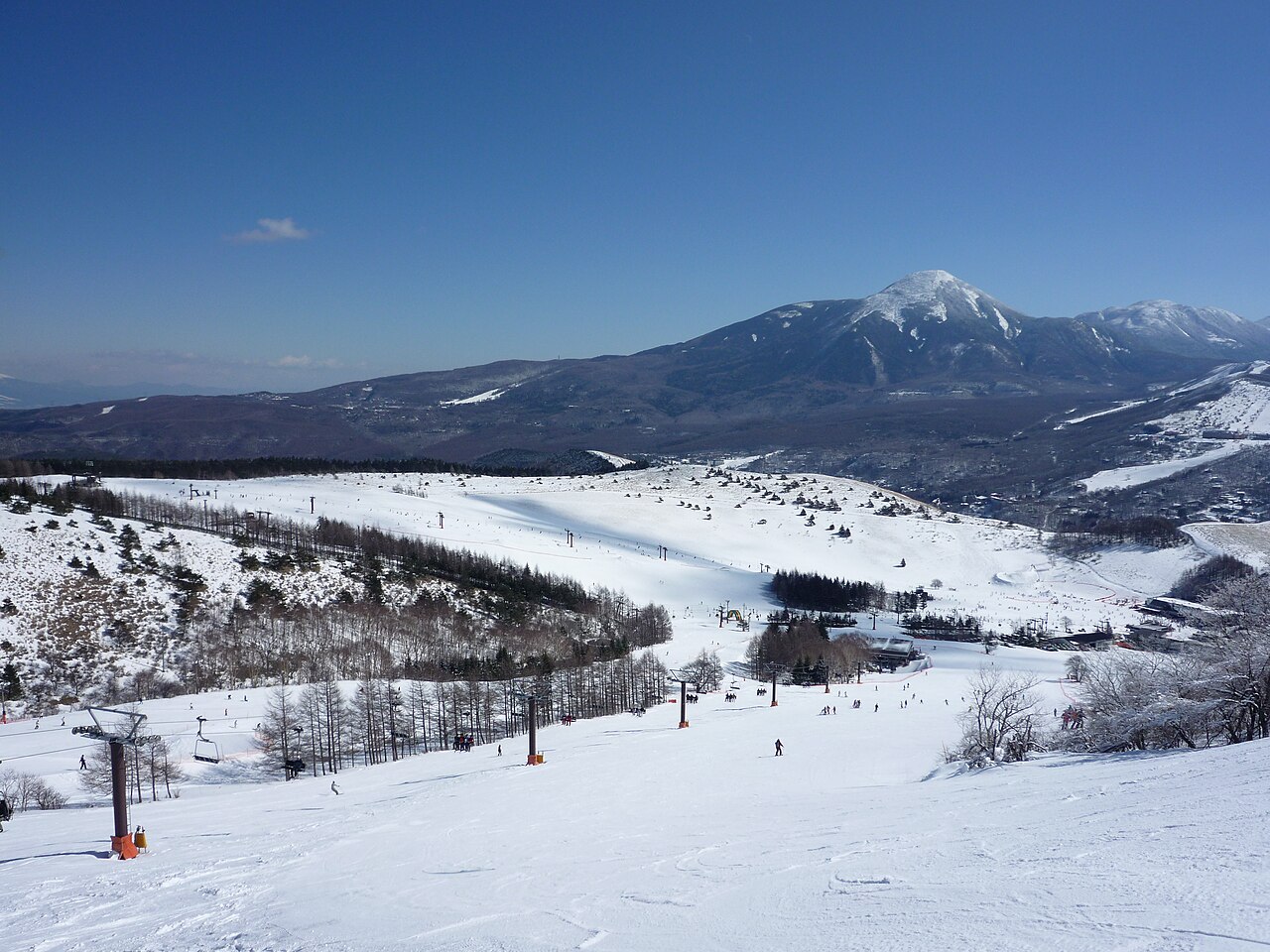
Kurumayama Kogen SKYPARK is a downhill ski area in Nagano Prefecture, Japan. Mapped terrain includes easy, intermediate, advanced routes. Its mapped lift network extends from approximately 1569 to 1911 metres above sea level.
Data: OpenSkiData / OpenSkiMap, OpenStreetMap contributors (ODbL), Skimap.org, Who's On First, Mapterhorn.
Kurumayama Kogen SKYPARK - Base lift station
ECMWF · Ejecución del modelo: Próxima actualización prevista:
Día Hora (UTC) Temp. (°C) Humedad (%) Viento (km/h) Viento (nudos) Viento (Bft) Dirección Precip. (mm) Nieve nueva (cm) Presión (hPa) Isoterma de 0 °C (m) Condiciones | Miércoles, 04/11 06:00 6.2 87 18 10 3B SE — — 1027 3152 Overcast 99% cloud 09:00 6.2 91 23 12 4B SE 0.21 0 1027 3156 Overcast 100% cloud 12:00 6.3 91 27 14 4B SE 2.4 0 1027 3151 Overcast 100% cloud 15:00 6.7 92 20 11 4B SE 2.5 0 1024 3140 Overcast 100% cloud 18:00 7.3 92 17 9 3B SE 2.9 0 1022 3130 Overcast 100% cloud 21:00 8.6 85 15 8 3B SE 1.9 0 1020 3119 Overcast 99% cloud Jueves, 05/11 00:00 9.2 86 8 5 2B SE 0 0 1018 3108 Cloudy 70% cloud 03:00 12.6 69 13 7 3B SW 0.06 0 1013 3079 Cloudy 78% cloud 06:00 13.2 59 13 7 3B SW 0 0 1010 3058 Partly cloudy 24% cloud 09:00 8.8 77 11 6 2B SW 0 0 1009 3051 Partly cloudy 39% cloud 12:00 7.9 75 13 7 3B W 0.05 0 1008 3038 Clear 14% cloud 15:00 7.8 76 16 9 3B SW 0.01 0 1006 3021 Partly cloudy 40% cloud 18:00 7.1 86 19 10 3B W 0.46 0 1005 3006 Cloudy 58% cloud 21:00 6.3 94 14 8 3B W 0.56 0 1007 3009 Cloudy 73% cloud Viernes, 06/11 00:00 9.9 81 18 10 3B W 0.32 0 1009 3022 Clear 19% cloud 03:00 12.1 45 25 13 4B W 0.09 0 1008 3020 Clear 10% cloud 06:00 11.2 45 26 14 4B W 0 0 1009 3005 Clear 19% cloud 09:00 6.8 65 19 11 3B W 0 0 1012 2878 Partly cloudy 23% cloud 12:00 4 78 19 10 3B W 0 0 1014 2474 Partly cloudy 22% cloud 15:00 2.7 83 18 10 3B W 0 0 1015 2116 Cloudy 57% cloud 18:00 1.2 84 20 11 4B W 0 0 1017 1795 Partly cloudy 36% cloud 21:00 -0 78 22 12 4B W 0.04 0 1019 1563 Partly cloudy 42% cloud Sábado, 07/11 00:00 1.2 69 25 14 4B W 0.08 0 1021 1757 Partly cloudy 47% cloud 03:00 2.5 55 32 17 5B W 0 0 1020 1902 Partly cloudy 32% cloud 06:00 1.6 58 26 14 4B W 0 0 1023 1811 Partly cloudy 26% cloud 09:00 -0.7 67 14 8 3B W 0 0 1027 1402 Partly cloudy 28% cloud 12:00 -0.7 58 11 6 2B W 0 0 1029 < 1220 Clear 19% cloud 15:00 -0.3 45 9 5 2B NW 0 0 1029 < 1220 Clear 11% cloud 18:00 -0.4 51 12 7 3B N 0 0 1030 < 1220 Clear 10% cloud 21:00 -0.6 58 11 6 2B N 0 0 1032 < 1220 Clear 10% cloud Domingo, 08/11 00:00 0.7 53 8 4 2B NW 0 0 1032 2953 Partly cloudy 41% cloud 03:00 3.1 49 8 5 2B NW 0 0 1029 2759 Partly cloudy 36% cloud 06:00 4 49 9 5 2B NW 0 0 1028 2855 Cloudy 76% cloud 09:00 3.1 60 4 2 1B NW 0 0 1030 2532 Overcast 93% cloud 12:00 2.7 67 8 4 2B SW 0 0 1031 2377 Overcast 94% cloud 15:00 3.8 68 14 7 3B SW 0 0 1029 2422 Overcast 95% cloud 18:00 3.8 68 9 5 2B SW 0 0 1028 2336 Overcast 95% cloud 21:00 3.9 69 10 5 2B SW 0.01 0 1027 2284 Overcast 96% cloud Lunes, 09/11 00:00 4.6 75 14 8 3B SW 0.30 0 1026 2439 Cloudy 78% cloud 03:00 6.4 62 14 8 3B SW 0.07 0 1021 2557 Partly cloudy 42% cloud 06:00 7.4 56 11 6 2B W 0 0 1019 2481 Partly cloudy 44% cloud 09:00 4.6 72 11 6 2B NW 0 0 1022 2246 Partly cloudy 37% cloud 12:00 3.3 77 12 6 2B NW 0.18 0 1023 2085 Partly cloudy 33% cloud 15:00 0.4 88 20 11 4B N 0.15 0 1024 1655 Overcast 90% cloud 18:00 -1.4 87 23 13 4B N 0.02 0 1025 1344 Overcast 81% cloud 21:00 -2.4 87 19 10 3B NW 0 0 1026 < 1220 Cloudy 65% cloud Martes, 10/11 00:00 -1.7 78 17 9 3B NW 0 0 1026 1414 Partly cloudy 21% cloud 03:00 0.3 67 13 7 3B NW 0 0 1024 1644 Clear 19% cloud 06:00 1.4 62 11 6 2B NW 0 0 1023 1837 Clear 4% cloud |
|---|
Forecast notes
Forecast table times: UTC.
Coordinates: 36.1017865°N, 138.2133131°E · Requested elevation: 1569 m. Model terrain: 1218 m. Terrain and 1000/925/850/700 hPa profiles are used for height estimates.
These are altitude estimates, not a simulation of local mountain terrain. Precipitation, cloud and sea-level pressure use horizontal interpolation only.
Precipitation includes rain and snow water equivalent: preceding 3 hours through day 6, then 6 hours (see cell tooltip). Snow (cm) estimates fresh snowfall from precipitation and temperature using the GFS conversion; it is not snow depth on the ground. Freezing (m) uses additional 600/500 hPa temperatures when available and estimates the lowest resolved 0°C crossing above sea level. When all sampled levels are warm, the upper profile limit is shown (see tooltip). < marks an entirely cold sampled profile and its lower height limit. No extrapolation is used.
Source: ECMWF · CC BY 4.0 · Processed by Snow Report.
Kurumayama Kogen SKYPARK - Top lift station
ECMWF · Ejecución del modelo: Próxima actualización prevista:
Día Hora (UTC) Temp. (°C) Humedad (%) Viento (km/h) Viento (nudos) Viento (Bft) Dirección Precip. (mm) Nieve nueva (cm) Presión (hPa) Isoterma de 0 °C (m) Condiciones | Miércoles, 04/11 06:00 5.1 89 21 11 4B S — — 1027 3152 Overcast 99% cloud 09:00 5.2 91 24 13 4B S 0.20 0 1027 3156 Overcast 100% cloud 12:00 5 92 31 16 5B S 2.3 0 1027 3151 Overcast 100% cloud 15:00 5.6 93 26 14 4B S 2.5 0 1024 3140 Overcast 100% cloud 18:00 6.2 92 20 11 3B S 3.0 0 1022 3129 Overcast 100% cloud 21:00 7.4 79 13 7 3B S 1.9 0 1020 3119 Overcast 99% cloud Jueves, 05/11 00:00 7.8 79 12 6 2B S 0 0 1018 3107 Cloudy 71% cloud 03:00 10.4 68 26 14 4B SW 0.06 0 1013 3078 Cloudy 77% cloud 06:00 10.9 60 25 13 4B SW 0 0 1009 3058 Partly cloudy 24% cloud 09:00 7.6 76 22 12 4B SW 0 0 1009 3051 Partly cloudy 40% cloud 12:00 6.9 78 24 13 4B W 0.05 0 1008 3038 Clear 15% cloud 15:00 6.7 78 30 16 5B W 0.01 0 1006 3021 Partly cloudy 41% cloud 18:00 5.9 81 35 19 5B W 0.47 0 1005 3006 Cloudy 58% cloud 21:00 5.1 91 25 13 4B W 0.56 0 1007 3009 Cloudy 72% cloud Viernes, 06/11 00:00 7.7 76 28 15 4B W 0.30 0 1009 3022 Clear 19% cloud 03:00 9.3 43 36 19 5B W 0.09 0 1008 3020 Clear 11% cloud 06:00 8.5 43 35 19 5B W 0 0 1009 3012 Clear 19% cloud 09:00 5.1 57 29 16 5B W 0 0 1012 2884 Partly cloudy 23% cloud 12:00 2.6 67 30 16 5B W 0 0 1014 2487 Partly cloudy 22% cloud 15:00 1.1 75 28 15 4B W 0 0 1015 2126 Cloudy 57% cloud 18:00 -0.6 77 31 17 5B W 0 0 1017 1805 Partly cloudy 37% cloud 21:00 -1.7 72 36 19 5B W 0.04 0 1019 1580 Partly cloudy 42% cloud Sábado, 07/11 00:00 -1 67 39 21 5B W 0.08 0 1021 1764 Partly cloudy 46% cloud 03:00 -0.1 55 43 23 6B W 0 0 1020 1906 Partly cloudy 32% cloud 06:00 -0.6 55 39 21 5B W 0 0 1023 1816 Partly cloudy 26% cloud 09:00 -1.8 56 31 17 5B W 0 0 1027 1416 Partly cloudy 28% cloud 12:00 -1.4 47 26 14 4B W 0 0 1029 < 1197 Clear 19% cloud 15:00 -0.9 38 24 13 4B NW 0 0 1029 < 1197 Clear 13% cloud 18:00 -0.4 41 25 14 4B NW 0 0 1030 < 1197 Clear 12% cloud 21:00 -0.7 48 21 11 4B NW 0 0 1032 < 1197 Clear 11% cloud Domingo, 08/11 00:00 0.5 45 17 9 3B NW 0 0 1032 2965 Partly cloudy 41% cloud 03:00 2.1 44 15 8 3B W 0 0 1029 2760 Partly cloudy 36% cloud 06:00 2.9 45 15 8 3B W 0 0 1028 2854 Cloudy 75% cloud 09:00 2 55 13 7 3B W 0 0 1030 2529 Overcast 93% cloud 12:00 1.6 62 17 9 3B SW 0 0 1031 2376 Overcast 94% cloud 15:00 2.3 65 23 13 4B SW 0 0 1029 2420 Overcast 95% cloud 18:00 2.1 64 21 11 4B SW 0 0 1028 2335 Overcast 95% cloud 21:00 2 68 23 12 4B SW 0.01 0 1027 2284 Overcast 96% cloud Lunes, 09/11 00:00 2.8 75 26 14 4B SW 0.29 0 1026 2441 Cloudy 77% cloud 03:00 4.2 65 23 12 4B SW 0.07 0 1021 2559 Partly cloudy 44% cloud 06:00 4.6 61 18 10 3B W 0 0 1019 2482 Partly cloudy 45% cloud 09:00 2.3 73 17 9 3B W 0 0 1022 2249 Partly cloudy 37% cloud 12:00 1.1 77 19 10 3B NW 0.18 0 1023 2086 Partly cloudy 34% cloud 15:00 -1.1 79 21 11 4B NW 0.15 0 1024 1658 Overcast 90% cloud 18:00 -2.3 72 25 14 4B NW 0.03 0 1025 1345 Overcast 82% cloud 21:00 -3 72 24 13 4B NW 0 0 1026 < 1197 Cloudy 67% cloud Martes, 10/11 00:00 -2.5 65 20 11 3B NW 0 0 1026 1406 Partly cloudy 24% cloud 03:00 -1.2 59 16 9 3B NW 0 0 1024 1634 Clear 19% cloud 06:00 -0.4 57 15 8 3B NW 0 0 1023 1834 Clear 4% cloud |
|---|
Forecast notes
Forecast table times: UTC.
Coordinates: 36.1030681°N, 138.1985137°E · Requested elevation: 1911 m. Model terrain: 1195 m. Terrain and 1000/925/850/700 hPa profiles are used for height estimates.
These are altitude estimates, not a simulation of local mountain terrain. Precipitation, cloud and sea-level pressure use horizontal interpolation only.
Precipitation includes rain and snow water equivalent: preceding 3 hours through day 6, then 6 hours (see cell tooltip). Snow (cm) estimates fresh snowfall from precipitation and temperature using the GFS conversion; it is not snow depth on the ground. Freezing (m) uses additional 600/500 hPa temperatures when available and estimates the lowest resolved 0°C crossing above sea level. When all sampled levels are warm, the upper profile limit is shown (see tooltip). < marks an entirely cold sampled profile and its lower height limit. No extrapolation is used.