Previsiones para estaciones de esquí de todo el mundo

Guía de colores Temperatura · Viento · Lluvia · Nieve
Cada color comienza en el valor indicado. Los colores del viento coinciden en las tres unidades. Las celdas sin precipitación permanecen neutras. Los colores describen los valores mostrados, no son avisos meteorológicos oficiales.
Preparando gráficos de previsión…
Las horas y los valores coinciden con la previsión detallada. Toca un valor para ver detalles y desplaza los gráficos horizontalmente para los próximos días. La precipitación es el equivalente total en agua por intervalo, incluida la nieve; la nieve nueva corresponde a cada intervalo, no al espesor de nieve en el suelo.
Comparación de GFS y ECMWF. Cada modelo conserva sus propias horas y horizonte de previsión. Las cantidades de precipitación y nieve corresponden a sus propios intervalos, que pueden diferir entre modelos.
Valores de previsión y notas de los modelos
Iwate Kogen Snow Park - Low lift station
ECMWF · Ejecución del modelo: Próxima actualización prevista:
Día Hora (UTC) Temp. (°C) Humedad (%) Viento (km/h) Viento (nudos) Viento (Bft) Dirección Precip. (mm) Nieve nueva (cm) Presión (hPa) Isoterma de 0 °C (m) Condiciones | Miércoles, 04/11 06:00 10.4 51 8 4 2B SW — — 1028 2046 Overcast 86% cloud  09:00 6.8 66 4 2 1B SW 0 0 1028 2396 Overcast 100% cloud 12:00 6.1 70 8 4 2B S 0 0 1028 2681 Overcast 100% cloud 15:00 5 79 6 3 2B S 0 0 1027 2661 Overcast 100% cloud 18:00 5.4 91 7 4 2B SW 0 0 1025 2475 Overcast 100% cloud 21:00 6.4 96 6 3 2B SW 2.9 0 1024 2566 Overcast 100% cloud Jueves, 05/11 00:00 8.3 97 7 4 2B S 5.6 0 1021 2780 Overcast 100% cloud 03:00 9.6 98 10 6 2B SE 1.6 0 1016 2848 Overcast 100% cloud 06:00 10.2 98 9 5 2B SE 1.2 0 1012 2927 Overcast 100% cloud 09:00 10 98 9 5 2B S 2.1 0 1010 2927 Overcast 100% cloud 12:00 10.1 97 8 4 2B SW 0.81 0 1007 2917 Overcast 100% cloud 15:00 9.7 96 10 5 2B SW 0.69 0 1004 2977 Overcast 83% cloud 18:00 9.8 97 14 7 3B W 0.16 0 1002 2876 Overcast 96% cloud 21:00 9.4 98 15 8 3B W 0.52 0 1002 2667 Overcast 100% cloud Viernes, 06/11 00:00 10.4 94 16 9 3B W 0.52 0 1003 2404 Overcast 93% cloud 03:00 11.6 68 28 15 4B W 0.78 0 1002 2230 Overcast 94% cloud 06:00 10.5 82 24 13 4B W 0.44 0 1003 2341 Overcast 98% cloud 09:00 7.3 85 29 16 5B W 1.1 0 1007 1946 Cloudy 69% cloud  12:00 4.5 93 29 16 5B W 1.1 0 1009 1388 Overcast 99% cloud 15:00 2 93 30 16 5B W 2.9 0 1011 940 Overcast 99% cloud 18:00 0.6 84 28 15 4B W 1.1 0.3 1012 731 Overcast 96% cloud 21:00 -0 87 22 12 4B W 1.4 0.4 1013 642 Overcast 100% cloud Sábado, 07/11 00:00 0.8 74 24 13 4B W 0.91 0.3 1014 733 Cloudy 51% cloud 03:00 1.7 63 32 17 5B W 1.1 0 1013 818 Cloudy 53% cloud 06:00 0.9 67 28 15 4B W 0.86 0.3 1015 749 Cloudy 57% cloud 09:00 -0.2 80 31 17 5B W 1.1 0.3 1017 624 Overcast 90% cloud 12:00 -0.2 83 28 15 4B W 1.1 0.3 1020 616 Overcast 89% cloud 15:00 -0.4 81 28 15 4B W 0.77 0.2 1022 587 Cloudy 75% cloud 18:00 -0.7 78 26 14 4B W 0.54 0.2 1024 561 Overcast 81% cloud 21:00 -0.7 82 23 12 4B W 0.34 0.1 1026 548 Overcast 90% cloud Domingo, 08/11 00:00 1.4 70 29 16 5B W 0.27 0 1027 807 Overcast 91% cloud 03:00 2.2 65 31 17 5B W 0.08 0 1027 881 Overcast 92% cloud 06:00 1.8 66 25 13 4B W 0.06 0 1029 840 Overcast 97% cloud 09:00 0.6 75 20 11 4B W 0.05 0 1030 724 Overcast 85% cloud 12:00 0.3 79 14 8 3B W 0.02 0 1031 687 Overcast 94% cloud 15:00 0.3 76 13 7 3B W 0.04 0 1030 698 Overcast 95% cloud 18:00 -0.3 79 12 7 3B W 0.06 0 1029 596 Overcast 91% cloud 21:00 -1.3 87 11 6 2B W 0.19 0 1029 < 505 Cloudy 79% cloud Lunes, 09/11 00:00 1.9 73 10 5 2B W 0.03 0 1028 872 Overcast 89% cloud 03:00 3.2 65 10 6 2B W 0.01 0 1025 974 Overcast 97% cloud 06:00 1.9 78 9 5 2B W 0.19 0 1024 896 Overcast 96% cloud 09:00 0.3 88 10 6 2B W 0.67 0.2 1024 704 Overcast 92% cloud 12:00 -0.2 92 14 8 3B W 0.54 0.2 1023 614 Overcast 93% cloud 15:00 -1.8 84 19 10 3B W 0.15 0 1022 < 505 Overcast 83% cloud 18:00 -1.4 79 27 15 4B W 0.26 0.1 1022 < 505 Overcast 85% cloud 21:00 -2.6 77 22 12 4B NW 0.26 0.1 1023 < 505 Cloudy 74% cloud Martes, 10/11 00:00 -1.8 63 17 9 3B NW 0.00 0 1026 < 505 Cloudy 51% cloud 03:00 -0.8 64 10 6 2B NW 0.06 0 1026 571 Cloudy 73% cloud 06:00 -0.9 62 6 3 2B NW 0.00 0 1027 558 Partly cloudy 49% cloud  |
|---|
Forecast notes
Forecast table times: UTC.
Coordinates: 39.813996°N, 140.9670299°E · Requested elevation: 646 m. Model terrain: 502 m. Terrain and 1000/925/850/700 hPa profiles are used for height estimates.
These are altitude estimates, not a simulation of local mountain terrain. Precipitation, cloud and sea-level pressure use horizontal interpolation only.
Precipitation includes rain and snow water equivalent: preceding 3 hours through day 6, then 6 hours (see cell tooltip). Snow (cm) estimates fresh snowfall from precipitation and temperature using the GFS conversion; it is not snow depth on the ground. Freezing (m) uses additional 600/500 hPa temperatures when available and estimates the lowest resolved 0°C crossing above sea level. When all sampled levels are warm, the upper profile limit is shown (see tooltip). < marks an entirely cold sampled profile and its lower height limit. No extrapolation is used.
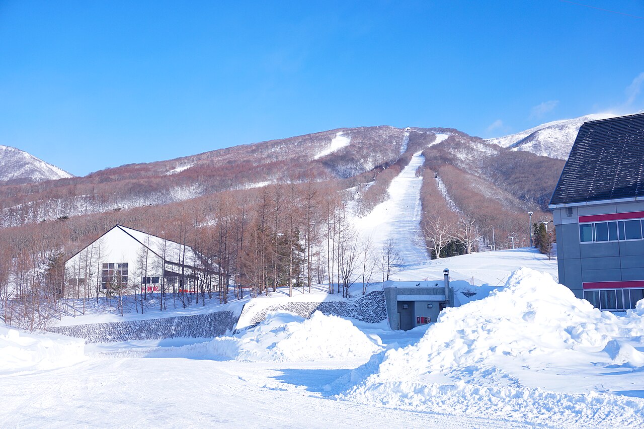
Iwate Kogen Snow Park is a downhill ski area in Iwate Prefecture, Japan. Mapped terrain includes beginner, easy, intermediate, advanced routes. Its mapped lift network extends from approximately 646 to 1207 metres above sea level.
Data: OpenSkiData / OpenSkiMap, OpenStreetMap contributors (ODbL), Skimap.org, Who's On First, Mapterhorn.
Preparando gráficos de previsión…
Las horas y los valores coinciden con la previsión detallada. Toca un valor para ver detalles y desplaza los gráficos horizontalmente para los próximos días. La precipitación es el equivalente total en agua por intervalo, incluida la nieve; la nieve nueva corresponde a cada intervalo, no al espesor de nieve en el suelo.
Comparación de GFS y ECMWF. Cada modelo conserva sus propias horas y horizonte de previsión. Las cantidades de precipitación y nieve corresponden a sus propios intervalos, que pueden diferir entre modelos.
Valores de previsión y notas de los modelos
Iwate Kogen Snow Park - Base lift station
ECMWF · Ejecución del modelo: Próxima actualización prevista:
Día Hora (UTC) Temp. (°C) Humedad (%) Viento (km/h) Viento (nudos) Viento (Bft) Dirección Precip. (mm) Nieve nueva (cm) Presión (hPa) Isoterma de 0 °C (m) Condiciones | Miércoles, 04/11 06:00 10.4 51 8 4 2B SW — — 1028 2045 Overcast 86% cloud 09:00 6.8 66 4 2 1B SW 0 0 1028 2395 Overcast 100% cloud 12:00 6.1 70 8 4 2B S 0 0 1028 2681 Overcast 100% cloud 15:00 4.9 79 6 3 2B S 0 0 1027 2661 Overcast 100% cloud 18:00 5.5 91 7 4 2B S 0 0 1025 2475 Overcast 100% cloud 21:00 6.4 96 6 3 2B SW 2.9 0 1024 2565 Overcast 100% cloud Jueves, 05/11 00:00 8.3 97 7 4 2B S 5.6 0 1021 2779 Overcast 100% cloud 03:00 9.6 98 10 6 2B SE 1.6 0 1016 2848 Overcast 100% cloud 06:00 10.2 98 9 5 2B SE 1.2 0 1012 2928 Overcast 100% cloud 09:00 10 98 9 5 2B S 2.1 0 1010 2927 Overcast 100% cloud 12:00 10.1 97 7 4 2B SW 0.82 0 1007 2917 Overcast 100% cloud 15:00 9.7 96 10 5 2B SW 0.69 0 1004 2977 Overcast 84% cloud 18:00 9.8 97 13 7 3B W 0.16 0 1002 2874 Overcast 96% cloud 21:00 9.4 98 15 8 3B W 0.53 0 1002 2665 Overcast 100% cloud Viernes, 06/11 00:00 10.4 94 16 9 3B W 0.53 0 1003 2403 Overcast 93% cloud 03:00 11.6 68 28 15 4B W 0.79 0 1002 2229 Overcast 94% cloud 06:00 10.5 82 24 13 4B W 0.44 0 1003 2340 Overcast 98% cloud 09:00 7.3 85 29 16 5B W 1.1 0 1007 1942 Cloudy 69% cloud 12:00 4.5 93 29 16 4B W 1.1 0 1009 1385 Overcast 99% cloud 15:00 2 93 30 16 5B W 2.9 0 1011 938 Overcast 99% cloud 18:00 0.6 84 27 15 4B W 1.1 0.3 1012 730 Overcast 96% cloud 21:00 -0 87 22 12 4B W 1.4 0.4 1013 642 Overcast 100% cloud Sábado, 07/11 00:00 0.8 74 24 13 4B W 0.92 0.3 1014 733 Cloudy 52% cloud 03:00 1.7 63 32 17 5B W 1.1 0 1013 817 Cloudy 54% cloud 06:00 0.9 67 28 15 4B W 0.87 0.3 1015 748 Cloudy 58% cloud 09:00 -0.2 80 31 16 5B W 1.1 0.3 1017 623 Overcast 90% cloud 12:00 -0.2 83 27 15 4B W 1.1 0.3 1020 616 Overcast 89% cloud 15:00 -0.4 81 28 15 4B W 0.79 0.2 1022 588 Cloudy 75% cloud 18:00 -0.7 78 26 14 4B W 0.54 0.2 1024 560 Overcast 80% cloud 21:00 -0.7 82 23 12 4B W 0.35 0.1 1026 547 Overcast 90% cloud Domingo, 08/11 00:00 1.4 70 29 16 5B W 0.27 0 1027 806 Overcast 91% cloud 03:00 2.2 65 31 17 5B W 0.08 0 1027 880 Overcast 93% cloud 06:00 1.7 66 25 13 4B W 0.06 0 1029 839 Overcast 97% cloud 09:00 0.6 75 20 11 4B W 0.05 0 1030 723 Overcast 85% cloud 12:00 0.3 79 14 8 3B W 0.02 0 1031 687 Overcast 94% cloud 15:00 0.3 76 13 7 3B W 0.04 0 1030 697 Overcast 95% cloud 18:00 -0.3 79 12 7 3B W 0.06 0 1029 597 Overcast 91% cloud 21:00 -1.3 87 11 6 2B W 0.19 0 1029 < 507 Cloudy 79% cloud Lunes, 09/11 00:00 1.9 73 10 5 2B W 0.03 0 1028 871 Overcast 89% cloud 03:00 3.2 65 10 6 2B W 0.01 0 1025 973 Overcast 97% cloud 06:00 1.9 78 9 5 2B W 0.19 0 1024 895 Overcast 96% cloud 09:00 0.3 88 10 6 2B W 0.68 0.2 1024 703 Overcast 92% cloud 12:00 -0.2 92 14 8 3B W 0.54 0.2 1023 613 Overcast 93% cloud 15:00 -1.8 84 19 10 3B W 0.15 0 1022 < 507 Overcast 83% cloud 18:00 -1.4 79 27 15 4B W 0.27 0.1 1022 < 507 Overcast 85% cloud 21:00 -2.6 78 22 12 4B NW 0.27 0.1 1023 < 507 Cloudy 74% cloud Martes, 10/11 00:00 -1.9 63 17 9 3B NW 0.00 0 1026 < 507 Cloudy 52% cloud 03:00 -0.8 64 10 6 2B NW 0.06 0 1026 570 Cloudy 74% cloud 06:00 -0.9 62 6 3 2B NW 0.00 0 1027 556 Partly cloudy 49% cloud |
|---|
Forecast notes
Forecast table times: UTC.
Coordinates: 39.8150962°N, 140.9648842°E · Requested elevation: 646 m. Model terrain: 505 m. Terrain and 1000/925/850/700 hPa profiles are used for height estimates.
These are altitude estimates, not a simulation of local mountain terrain. Precipitation, cloud and sea-level pressure use horizontal interpolation only.
Precipitation includes rain and snow water equivalent: preceding 3 hours through day 6, then 6 hours (see cell tooltip). Snow (cm) estimates fresh snowfall from precipitation and temperature using the GFS conversion; it is not snow depth on the ground. Freezing (m) uses additional 600/500 hPa temperatures when available and estimates the lowest resolved 0°C crossing above sea level. When all sampled levels are warm, the upper profile limit is shown (see tooltip). < marks an entirely cold sampled profile and its lower height limit. No extrapolation is used.
Preparando gráficos de previsión…
Las horas y los valores coinciden con la previsión detallada. Toca un valor para ver detalles y desplaza los gráficos horizontalmente para los próximos días. La precipitación es el equivalente total en agua por intervalo, incluida la nieve; la nieve nueva corresponde a cada intervalo, no al espesor de nieve en el suelo.
Comparación de GFS y ECMWF. Cada modelo conserva sus propias horas y horizonte de previsión. Las cantidades de precipitación y nieve corresponden a sus propios intervalos, que pueden diferir entre modelos.
Valores de previsión y notas de los modelos
Iwate Kogen Snow Park - Top lift station
ECMWF · Ejecución del modelo: Próxima actualización prevista:
Día Hora (UTC) Temp. (°C) Humedad (%) Viento (km/h) Viento (nudos) Viento (Bft) Dirección Precip. (mm) Nieve nueva (cm) Presión (hPa) Isoterma de 0 °C (m) Condiciones | Miércoles, 04/11 06:00 5 60 14 7 3B W — — 1028 2041 Overcast 83% cloud 09:00 5.2 49 11 6 2B SW 0 0 1028 2387 Overcast 100% cloud 12:00 5 65 22 12 4B S 0 0 1028 2677 Overcast 100% cloud 15:00 4.4 62 26 14 4B S 0 0 1027 2660 Overcast 100% cloud 18:00 4.8 87 29 15 4B SW 0 0 1025 2480 Overcast 100% cloud 21:00 5.2 85 24 13 4B SW 2.8 0 1024 2564 Overcast 100% cloud Jueves, 05/11 00:00 6.4 91 37 20 5B S 5.6 0 1021 2775 Overcast 100% cloud 03:00 7.7 97 47 25 6B S 1.6 0 1016 2846 Overcast 100% cloud 06:00 8.4 98 44 24 6B SE 1.2 0 1012 2929 Overcast 100% cloud 09:00 8.4 96 38 21 5B S 2.2 0 1010 2925 Overcast 100% cloud 12:00 8.9 96 35 19 5B SW 0.82 0 1007 2915 Overcast 100% cloud 15:00 8.2 92 38 20 5B SW 0.66 0 1004 2977 Overcast 84% cloud 18:00 8 90 45 25 6B W 0.16 0 1002 2868 Overcast 95% cloud 21:00 6.8 95 47 25 6B W 0.51 0 1002 2663 Overcast 100% cloud Viernes, 06/11 00:00 6.4 90 47 25 6B W 0.57 0 1003 2397 Overcast 93% cloud 03:00 5.6 85 51 28 7B W 0.76 0 1002 2225 Overcast 95% cloud 06:00 6.3 91 64 34 8B W 0.43 0 1003 2335 Overcast 98% cloud 09:00 3.7 79 65 35 8B W 1.1 0 1007 1935 Cloudy 71% cloud 12:00 1 88 62 33 7B W 1.1 0.3 1009 1374 Overcast 99% cloud 15:00 -1.9 85 70 38 8B W 2.9 0.9 1011 933 Overcast 99% cloud 18:00 -3.5 83 66 36 8B W 1.1 1.1 1012 725 Overcast 96% cloud 21:00 -4.3 89 64 34 8B W 1.4 1.4 1013 643 Overcast 100% cloud Sábado, 07/11 00:00 -4.4 78 70 38 8B W 0.97 1 1014 730 Cloudy 54% cloud 03:00 -3.9 72 76 41 9B W 1.2 1.2 1013 812 Cloudy 57% cloud 06:00 -4.1 76 79 43 9B W 0.94 0.9 1015 740 Cloudy 61% cloud 09:00 -4.3 88 73 39 8B W 1.2 1.2 1017 619 Overcast 91% cloud 12:00 -4.3 88 70 38 8B W 1.2 1.2 1020 610 Overcast 90% cloud 15:00 -4.5 84 70 38 8B W 0.89 0.9 1022 586 Cloudy 77% cloud 18:00 -4.9 83 64 35 8B W 0.60 0.6 1024 552 Overcast 82% cloud 21:00 -4.8 87 56 30 7B W 0.40 0.4 1026 537 Overcast 91% cloud Domingo, 08/11 00:00 -3.6 78 63 34 8B W 0.31 0.3 1027 795 Overcast 91% cloud 03:00 -3.2 77 56 30 7B W 0.10 0.1 1027 875 Overcast 93% cloud 06:00 -3.4 79 47 26 6B W 0.07 0.1 1029 833 Overcast 97% cloud 09:00 -3.7 79 46 25 6B W 0.06 0.1 1030 717 Overcast 86% cloud 12:00 -4 84 37 20 5B W 0.02 0 1031 680 Overcast 95% cloud 15:00 -3.8 83 38 20 5B W 0.05 0.1 1030 690 Overcast 95% cloud 18:00 -4.1 86 38 20 5B W 0.08 0.1 1029 585 Overcast 92% cloud 21:00 -4 83 30 16 5B W 0.21 0.2 1029 < 518 Overcast 81% cloud Lunes, 09/11 00:00 -2.9 84 24 13 4B W 0.04 0 1028 859 Overcast 90% cloud 03:00 -2.4 83 16 9 3B W 0.02 0 1025 966 Overcast 97% cloud 06:00 -2.5 88 18 10 3B W 0.20 0 1024 889 Overcast 96% cloud 09:00 -3 88 25 14 4B W 0.66 0.7 1024 693 Overcast 92% cloud 12:00 -4.2 90 40 22 6B W 0.53 0.5 1023 612 Overcast 93% cloud 15:00 -5.5 79 53 28 7B W 0.15 0.1 1022 < 518 Overcast 83% cloud 18:00 -5.5 76 64 35 8B W 0.29 0.3 1022 < 518 Overcast 87% cloud 21:00 -7 74 54 29 7B NW 0.29 0.3 1023 < 518 Cloudy 74% cloud Martes, 10/11 00:00 -7.4 73 35 19 5B NW 0.01 0 1026 < 518 Cloudy 55% cloud 03:00 -6.8 83 19 10 3B NW 0.07 0.1 1026 556 Cloudy 75% cloud 06:00 -6.3 73 13 7 3B NW 0.01 0 1027 541 Partly cloudy 48% cloud |
|---|
Forecast notes
Forecast table times: UTC.
Coordinates: 39.8315741°N, 140.9668341°E · Requested elevation: 1207 m. Model terrain: 516 m. Terrain and 1000/925/850/700 hPa profiles are used for height estimates.
These are altitude estimates, not a simulation of local mountain terrain. Precipitation, cloud and sea-level pressure use horizontal interpolation only.
Precipitation includes rain and snow water equivalent: preceding 3 hours through day 6, then 6 hours (see cell tooltip). Snow (cm) estimates fresh snowfall from precipitation and temperature using the GFS conversion; it is not snow depth on the ground. Freezing (m) uses additional 600/500 hPa temperatures when available and estimates the lowest resolved 0°C crossing above sea level. When all sampled levels are warm, the upper profile limit is shown (see tooltip). < marks an entirely cold sampled profile and its lower height limit. No extrapolation is used.