Previsiones para estaciones de esquí de todo el mundo

Guía de colores Temperatura · Viento · Lluvia · Nieve
Cada color comienza en el valor indicado. Los colores del viento coinciden en las tres unidades. Las celdas sin precipitación permanecen neutras. Los colores describen los valores mostrados, no son avisos meteorológicos oficiales.
Gransnow Okuibuki - Low lift station
ECMWF · Ejecución del modelo: Próxima actualización prevista:
Día Hora (UTC) Temp. (°C) Humedad (%) Viento (km/h) Viento (nudos) Viento (Bft) Dirección Precip. (mm) Nieve nueva (cm) Presión (hPa) Isoterma de 0 °C (m) Condiciones | Miércoles, 04/11 06:00 13.5 49 5 3 1B SE — — 1024 3149 Overcast 100% cloud  09:00 12 75 4 2 1B S 0.19 0 1024 3152 Overcast 100% cloud 12:00 11.4 86 10 5 2B SE 0.94 0 1024 3144 Overcast 100% cloud 15:00 12.6 84 15 8 3B SE 0.72 0 1021 3139 Overcast 100% cloud 18:00 12 86 3 2 1B SW 0.04 0 1019 3125 Overcast 100% cloud 21:00 11.9 81 5 3 1B W 0.01 0 1017 3111 Overcast 99% cloud Jueves, 05/11 00:00 14.8 81 5 3 1B NW 0 0 1015 3103 Overcast 98% cloud 03:00 17.2 63 4 2 1B S 0 0 1012 3079 Partly cloudy 38% cloud  06:00 17.4 61 6 3 1B S 0 0 1009 3058 Partly cloudy 50% cloud 09:00 14.5 80 8 4 2B S 0.23 0 1009 3051 Cloudy 58% cloud  12:00 13.8 89 14 7 3B S 0.88 0 1008 3042 Overcast 99% cloud 15:00 13.2 97 17 9 3B SW 7.9 0 1007 3029 Overcast 90% cloud 18:00 12.8 99 23 12 4B W 1.8 0 1007 3018 Overcast 99% cloud 21:00 11.8 97 30 16 5B NW 1.1 0 1009 3024 Overcast 100% cloud Viernes, 06/11 00:00 12.1 91 30 16 5B NW 0.94 0 1012 3038 Overcast 85% cloud 03:00 13.6 65 32 17 5B NW 0.76 0 1012 3034 Partly cloudy 32% cloud 06:00 12.2 73 33 18 5B NW 0.25 0 1013 3035 Partly cloudy 47% cloud 09:00 9.5 91 30 16 5B NW 0.85 0 1016 2689 Overcast 82% cloud 12:00 7.9 89 30 16 5B NW 0.92 0 1018 2359 Cloudy 55% cloud 15:00 6.3 94 28 15 4B NW 0.92 0 1019 1854 Overcast 91% cloud 18:00 5.2 92 31 17 5B NW 0.88 0 1020 1534 Cloudy 52% cloud 21:00 4.9 93 32 17 5B NW 0.84 0 1022 1474 Overcast 84% cloud Sábado, 07/11 00:00 5 91 40 22 6B NW 1.1 0 1024 1444 Overcast 87% cloud 03:00 5.5 79 41 22 6B NW 0.94 0 1025 1465 Cloudy 51% cloud 06:00 5.5 74 40 22 6B NW 0.46 0 1026 1381 Cloudy 62% cloud 09:00 4 80 35 19 5B N 0.06 0 1028 1328 Partly cloudy 35% cloud 12:00 4 76 32 17 5B NW 0.05 0 1030 1234 Cloudy 63% cloud 15:00 3.8 72 32 18 5B N 0 0 1030 1219 Partly cloudy 45% cloud 18:00 3.4 77 30 16 5B N 0 0 1031 1197 Cloudy 74% cloud 21:00 3.2 78 30 16 5B N 0 0 1031 1290 Cloudy 70% cloud Domingo, 08/11 00:00 5.3 58 29 15 4B N 0 0 1032 3155 Cloudy 61% cloud 03:00 7.5 54 26 14 4B N 0 0 1030 3151 Overcast 92% cloud 06:00 7.8 57 20 11 4B N 0 0 1029 3059 Cloudy 71% cloud 09:00 7.2 56 9 5 2B N 0 0 1030 2702 Overcast 93% cloud 12:00 7.8 56 4 2 1B E 0 0 1030 2723 Overcast 99% cloud 15:00 7.5 60 1 1 1B NW 0 0 1029 2669 Overcast 98% cloud 18:00 7.5 55 9 5 2B NW 0 0 1027 2488 Overcast 100% cloud 21:00 8.2 47 8 4 2B N 0 0 1026 2448 Overcast 100% cloud Lunes, 09/11 00:00 8.9 55 14 8 3B NW 0 0 1026 2592 Cloudy 76% cloud 03:00 10 62 21 12 4B NW 0 0 1024 2706 Clear 17% cloud  06:00 9.4 70 28 15 4B NW 0 0 1023 2431 Cloudy 50% cloud 09:00 7.9 89 29 16 5B NW 0.08 0 1024 2298 Overcast 81% cloud 12:00 7.4 90 26 14 4B NW 0.52 0 1023 2185 Cloudy 57% cloud 15:00 6.7 73 31 17 5B N 0.06 0 1023 2015 Partly cloudy 49% cloud 18:00 5 63 39 21 6B N 0 0 1023 2051 Clear 14% cloud 21:00 3.8 60 40 22 6B N 0 0 1025 1899 Clear 18% cloud Martes, 10/11 00:00 5.1 53 32 17 5B N 0 0 1026 1727 Clear 8% cloud 03:00 6.8 56 29 15 4B NW 0 0 1025 1849 Clear 4% cloud 06:00 6 60 31 17 5B NW 0 0 1024 2115 Clear 3% cloud |
|---|
Forecast notes
Forecast table times: UTC.
Coordinates: 35.5212889°N, 136.3856291°E · Requested elevation: 738 m. Model terrain: 428 m. Terrain and 1000/925/850/700 hPa profiles are used for height estimates.
These are altitude estimates, not a simulation of local mountain terrain. Precipitation, cloud and sea-level pressure use horizontal interpolation only.
Precipitation includes rain and snow water equivalent: preceding 3 hours through day 6, then 6 hours (see cell tooltip). Snow (cm) estimates fresh snowfall from precipitation and temperature using the GFS conversion; it is not snow depth on the ground. Freezing (m) uses additional 600/500 hPa temperatures when available and estimates the lowest resolved 0°C crossing above sea level. When all sampled levels are warm, the upper profile limit is shown (see tooltip). < marks an entirely cold sampled profile and its lower height limit. No extrapolation is used.
Source: ECMWF · CC BY 4.0 · Processed by Snow Report.
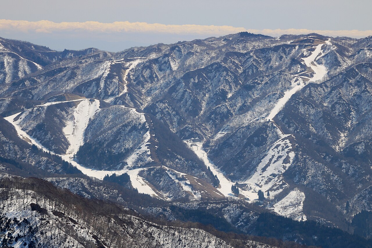
Gransnow Okuibuki is a downhill ski area in Gifu Prefecture, Japan. Mapped terrain includes easy, intermediate, advanced routes. Its mapped lift network extends from approximately 738 to 1221 metres above sea level.
Data: OpenSkiData / OpenSkiMap, OpenStreetMap contributors (ODbL), Skimap.org, Who's On First, Mapterhorn.
Gransnow Okuibuki - Base lift station
ECMWF · Ejecución del modelo: Próxima actualización prevista:
Día Hora (UTC) Temp. (°C) Humedad (%) Viento (km/h) Viento (nudos) Viento (Bft) Dirección Precip. (mm) Nieve nueva (cm) Presión (hPa) Isoterma de 0 °C (m) Condiciones | Miércoles, 04/11 06:00 13.4 49 5 3 1B SE — — 1024 3149 Overcast 100% cloud 09:00 12 75 4 2 1B S 0.19 0 1024 3152 Overcast 100% cloud 12:00 11.4 86 11 6 2B SE 0.94 0 1024 3144 Overcast 100% cloud 15:00 12.6 83 15 8 3B SE 0.72 0 1021 3139 Overcast 100% cloud 18:00 12 86 3 2 1B SW 0.04 0 1019 3125 Overcast 100% cloud 21:00 11.9 80 5 3 1B W 0.01 0 1017 3111 Overcast 99% cloud Jueves, 05/11 00:00 14.8 81 5 3 1B NW 0 0 1015 3104 Overcast 98% cloud 03:00 17.1 63 4 2 1B S 0 0 1012 3079 Partly cloudy 37% cloud 06:00 17.3 61 6 3 1B S 0 0 1009 3058 Partly cloudy 49% cloud 09:00 14.5 80 8 4 2B S 0.23 0 1009 3051 Cloudy 58% cloud 12:00 13.7 89 14 8 3B S 0.88 0 1008 3042 Overcast 99% cloud 15:00 13.2 97 18 10 3B SW 7.9 0 1007 3029 Overcast 90% cloud 18:00 12.7 99 23 13 4B W 1.8 0 1007 3018 Overcast 99% cloud 21:00 11.8 97 30 16 5B NW 1.1 0 1009 3024 Overcast 100% cloud Viernes, 06/11 00:00 12 91 30 16 5B NW 0.93 0 1012 3038 Overcast 85% cloud 03:00 13.5 65 33 18 5B NW 0.76 0 1012 3034 Partly cloudy 32% cloud 06:00 12.1 73 34 18 5B NW 0.25 0 1013 3035 Partly cloudy 48% cloud 09:00 9.4 91 30 16 5B NW 0.84 0 1016 2690 Overcast 82% cloud 12:00 7.8 89 31 17 5B NW 0.92 0 1018 2360 Cloudy 56% cloud 15:00 6.2 94 29 16 4B NW 0.92 0 1019 1855 Overcast 90% cloud 18:00 5.1 91 32 17 5B NW 0.87 0 1020 1534 Cloudy 52% cloud 21:00 4.8 93 32 17 5B NW 0.84 0 1022 1474 Overcast 84% cloud Sábado, 07/11 00:00 4.9 91 41 22 6B NW 1.1 0 1024 1444 Overcast 87% cloud 03:00 5.4 79 42 23 6B NW 0.94 0 1025 1465 Cloudy 51% cloud 06:00 5.4 75 41 22 6B NW 0.46 0 1026 1381 Cloudy 62% cloud 09:00 3.9 80 35 19 5B N 0.06 0 1028 1328 Partly cloudy 35% cloud 12:00 3.9 77 33 18 5B NW 0.05 0 1030 1233 Cloudy 62% cloud 15:00 3.7 72 33 18 5B N 0 0 1030 1219 Partly cloudy 45% cloud 18:00 3.3 77 31 17 5B N 0 0 1031 1197 Cloudy 74% cloud 21:00 3.1 78 30 16 5B N 0 0 1031 1291 Cloudy 70% cloud Domingo, 08/11 00:00 5.2 58 29 16 5B N 0 0 1032 3155 Cloudy 61% cloud 03:00 7.4 54 26 14 4B N 0 0 1030 3151 Overcast 92% cloud 06:00 7.7 57 20 11 4B N 0 0 1029 3059 Cloudy 71% cloud 09:00 7.2 55 9 5 2B N 0 0 1030 2702 Overcast 93% cloud 12:00 7.8 55 4 2 1B E 0 0 1030 2723 Overcast 99% cloud 15:00 7.5 60 1 1 1B W 0 0 1029 2669 Overcast 98% cloud 18:00 7.5 54 9 5 2B NW 0 0 1027 2488 Overcast 100% cloud 21:00 8.2 47 8 4 2B N 0 0 1026 2448 Overcast 100% cloud Lunes, 09/11 00:00 8.8 55 14 8 3B NW 0 0 1026 2591 Cloudy 76% cloud 03:00 9.9 63 22 12 4B NW 0 0 1024 2705 Clear 17% cloud 06:00 9.2 71 28 15 4B NW 0 0 1023 2431 Cloudy 50% cloud 09:00 7.8 89 30 16 5B NW 0.08 0 1024 2299 Overcast 81% cloud 12:00 7.4 90 27 15 4B NW 0.51 0 1023 2186 Cloudy 57% cloud 15:00 6.7 72 31 17 5B N 0.05 0 1023 2015 Partly cloudy 49% cloud 18:00 4.9 62 40 22 6B N 0 0 1023 2052 Clear 14% cloud 21:00 3.8 60 41 22 6B N 0 0 1025 1900 Clear 18% cloud Martes, 10/11 00:00 5 53 32 18 5B N 0 0 1026 1728 Clear 8% cloud 03:00 6.6 57 29 16 5B NW 0 0 1025 1850 Clear 4% cloud 06:00 5.9 60 31 17 5B NW 0 0 1024 2116 Clear 3% cloud |
|---|
Forecast notes
Forecast table times: UTC.
Coordinates: 35.5217862°N, 136.3877339°E · Requested elevation: 750 m. Model terrain: 429 m. Terrain and 1000/925/850/700 hPa profiles are used for height estimates.
These are altitude estimates, not a simulation of local mountain terrain. Precipitation, cloud and sea-level pressure use horizontal interpolation only.
Precipitation includes rain and snow water equivalent: preceding 3 hours through day 6, then 6 hours (see cell tooltip). Snow (cm) estimates fresh snowfall from precipitation and temperature using the GFS conversion; it is not snow depth on the ground. Freezing (m) uses additional 600/500 hPa temperatures when available and estimates the lowest resolved 0°C crossing above sea level. When all sampled levels are warm, the upper profile limit is shown (see tooltip). < marks an entirely cold sampled profile and its lower height limit. No extrapolation is used.
Source: ECMWF · CC BY 4.0 · Processed by Snow Report.
Gransnow Okuibuki - Top lift station
ECMWF · Ejecución del modelo: Próxima actualización prevista:
Día Hora (UTC) Temp. (°C) Humedad (%) Viento (km/h) Viento (nudos) Viento (Bft) Dirección Precip. (mm) Nieve nueva (cm) Presión (hPa) Isoterma de 0 °C (m) Condiciones | Miércoles, 04/11 06:00 10.2 68 18 10 3B SE — — 1024 3149 Overcast 100% cloud 09:00 9.7 85 30 16 5B SE 0.21 0 1024 3152 Overcast 100% cloud 12:00 9.9 92 39 21 6B SE 0.92 0 1024 3144 Overcast 100% cloud 15:00 11.2 86 28 15 4B S 0.66 0 1021 3140 Overcast 100% cloud 18:00 11.2 79 10 6 2B SW 0.03 0 1019 3125 Overcast 100% cloud 21:00 11.3 66 10 5 2B W 0.00 0 1017 3111 Overcast 99% cloud Jueves, 05/11 00:00 12.6 63 9 5 2B W 0 0 1015 3104 Overcast 98% cloud 03:00 13.4 57 5 3 1B SW 0 0 1012 3079 Partly cloudy 36% cloud 06:00 13.7 58 9 5 2B S 0 0 1009 3058 Partly cloudy 47% cloud 09:00 12.7 67 19 10 3B S 0.25 0 1009 3051 Cloudy 58% cloud 12:00 12 83 32 17 5B S 0.90 0 1008 3042 Overcast 99% cloud 15:00 11.6 96 44 24 6B SW 8.0 0 1007 3029 Overcast 91% cloud 18:00 10.5 99 47 26 6B W 1.8 0 1007 3018 Overcast 99% cloud 21:00 9.2 96 53 29 7B NW 0.99 0 1009 3024 Overcast 100% cloud Viernes, 06/11 00:00 8.9 91 49 26 6B NW 0.85 0 1012 3039 Overcast 84% cloud 03:00 8.9 67 49 27 6B NW 0.72 0 1012 3035 Partly cloudy 32% cloud 06:00 7.9 82 50 27 6B W 0.22 0 1013 3035 Partly cloudy 46% cloud 09:00 6.3 93 50 27 7B NW 0.76 0 1016 2715 Overcast 84% cloud 12:00 4.6 82 51 27 7B NW 0.91 0 1018 2380 Cloudy 55% cloud 15:00 3.1 92 48 26 6B NW 0.83 0 1019 1867 Overcast 90% cloud 18:00 2 84 54 29 7B NW 0.80 0 1020 1545 Cloudy 50% cloud 21:00 1.7 88 56 30 7B NW 0.78 0 1022 1477 Overcast 84% cloud Sábado, 07/11 00:00 1.5 91 59 32 7B NW 1.0 0 1024 1449 Overcast 86% cloud 03:00 1.7 82 60 32 7B NW 0.87 0 1025 1471 Partly cloudy 49% cloud 06:00 1.3 81 55 30 7B NW 0.42 0 1026 1383 Cloudy 63% cloud 09:00 0.7 81 51 28 7B NW 0.05 0 1028 1332 Partly cloudy 34% cloud 12:00 0.1 85 49 26 6B NW 0.05 0 1030 1233 Cloudy 59% cloud 15:00 -0 80 48 26 6B N 0 0 1030 1221 Partly cloudy 43% cloud 18:00 -0.2 84 47 25 6B N 0 0 1031 1199 Cloudy 72% cloud 21:00 0.4 72 45 24 6B N 0 0 1031 1305 Cloudy 70% cloud Domingo, 08/11 00:00 2.9 44 36 20 5B N 0 0 1032 3155 Cloudy 58% cloud 03:00 4.5 43 25 14 4B N 0 0 1030 3151 Overcast 93% cloud 06:00 5.6 44 13 7 3B N 0 0 1029 3064 Cloudy 71% cloud 09:00 5.8 45 5 3 1B E 0 0 1030 2705 Overcast 93% cloud 12:00 6.6 41 8 4 2B SE 0 0 1030 2729 Overcast 99% cloud 15:00 6.8 40 10 6 2B SW 0 0 1029 2677 Overcast 98% cloud 18:00 6.6 39 9 5 2B W 0 0 1027 2491 Overcast 100% cloud 21:00 7.2 44 13 7 3B NW 0 0 1026 2453 Overcast 100% cloud Lunes, 09/11 00:00 6.8 55 20 11 4B NW 0 0 1026 2595 Cloudy 76% cloud 03:00 6.5 64 27 15 4B NW 0 0 1023 2711 Clear 16% cloud 06:00 5.3 78 35 19 5B NW 0 0 1023 2446 Partly cloudy 48% cloud 09:00 5.2 91 44 24 6B NW 0.06 0 1024 2314 Cloudy 80% cloud 12:00 5.2 79 40 22 6B NW 0.49 0 1023 2196 Cloudy 54% cloud 15:00 4.4 65 41 22 6B N 0.05 0 1023 2022 Partly cloudy 46% cloud 18:00 3.6 47 49 26 6B N 0 0 1023 2063 Clear 13% cloud 21:00 2.5 56 54 29 7B N 0 0 1025 1922 Clear 17% cloud Martes, 10/11 00:00 2.1 50 50 27 6B N 0 0 1026 1753 Clear 7% cloud 03:00 3 46 39 21 5B N 0 0 1024 1868 Clear 4% cloud 06:00 3.6 33 33 18 5B N 0 0 1024 2134 Clear 2% cloud |
|---|
Forecast notes
Forecast table times: UTC.
Coordinates: 35.5136514°N, 136.399771°E · Requested elevation: 1221 m. Model terrain: 424 m. Terrain and 1000/925/850/700 hPa profiles are used for height estimates.
These are altitude estimates, not a simulation of local mountain terrain. Precipitation, cloud and sea-level pressure use horizontal interpolation only.
Precipitation includes rain and snow water equivalent: preceding 3 hours through day 6, then 6 hours (see cell tooltip). Snow (cm) estimates fresh snowfall from precipitation and temperature using the GFS conversion; it is not snow depth on the ground. Freezing (m) uses additional 600/500 hPa temperatures when available and estimates the lowest resolved 0°C crossing above sea level. When all sampled levels are warm, the upper profile limit is shown (see tooltip). < marks an entirely cold sampled profile and its lower height limit. No extrapolation is used.