SNOWREPORT
METEOCAM
Wettervorhersagen für Skigebiete weltweit
Wettermodelle GFS, ECMWF & ICON
Vorhersage bis zu 16 Tage
2,272 Skigebiete Neuestes Skigebiet: Moose Mountain Ski Resort ↗
125 Schnee-Webcams Neueste Webcam: Skeetawk ↗
Bergwetter-Kompetenz seit 1996

Farbskala Temperatur · Wind · Regen · Schnee
Temperatur °C< −10 / −10 / 0 / 10 / 20 / 30+
Wind km/h< 10 / 10 / 29 / 50 / 75+
Regen mm< 1 / 1 / 3 / 10 / 20+
Schnee cm< 1 / 1 / 5 / 10 / 20+
Jede Farbe beginnt beim angegebenen Wert. Die Windfarben stimmen in allen drei Einheiten überein. Trockene Zellen bleiben neutral. Die Farben beschreiben die Werte und sind keine amtlichen Wetterwarnungen.
Furano ski resort - Low lift station
ECMWF · Modelllauf: Nächste Aktualisierung erwartet:
Tag Uhrzeit (UTC) Temp. (°C) Luftfeuchtigkeit (%) Wind (km/h) Wind (Knoten) Wind (Bft) Richtung Niederschlag (mm) Neuschnee (cm) Luftdruck (hPa) Nullgradgrenze (m) Wetterlage | Mittwoch, 04/11 06:00 5.7 50 7 4 2B W — — 1027 1036 Clear 0% cloud  09:00 0.8 70 5 3 1B S 0 0 1027 587 Clear 1% cloud 12:00 0.7 70 7 4 2B S 0 0 1027 562 Partly cloudy 24% cloud  15:00 1 75 7 4 2B S 0 0 1026 535 Clear 8% cloud 18:00 1.6 77 8 4 2B S 0 0 1025 1717 Clear 9% cloud 21:00 1.6 72 6 4 2B S 0 0 1024 1860 Partly cloudy 47% cloud Donnerstag, 05/11 00:00 9.1 56 6 3 2B SE 0 0 1023 1877 Overcast 98% cloud  03:00 12.8 55 11 6 2B S 0 0 1018 1947 Cloudy 60% cloud  06:00 11.6 61 8 4 2B SE 0 0 1015 2095 Overcast 99% cloud 09:00 7.1 84 8 4 2B SE 0.68 0 1015 2038 Overcast 100% cloud 12:00 6.5 90 3 1 1B SE 2.1 0 1011 2135 Overcast 100% cloud 15:00 6.6 90 5 3 1B E 5.3 0 1006 2348 Overcast 100% cloud 18:00 7.1 92 3 2 1B SE 6.0 0 1001 2436 Overcast 100% cloud 21:00 6.9 93 3 1 1B NW 4.8 0 1000 2282 Overcast 100% cloud Freitag, 06/11 00:00 8.7 87 4 2 1B NW 0.96 0 999 2016 Cloudy 63% cloud 03:00 11.7 61 14 8 3B W 0.07 0 998 1714 Cloudy 56% cloud 06:00 11.4 59 7 4 2B W 0.04 0 998 1755 Clear 14% cloud 09:00 8.1 79 13 7 3B SW 0.19 0 998 1617 Cloudy 68% cloud 12:00 4.6 87 16 9 3B W 1.1 0 1002 923 Overcast 84% cloud 15:00 1.7 84 17 9 3B W 0.62 0 1003 529 Cloudy 76% cloud 18:00 -0.6 73 18 10 3B SW 0.61 0.2 1003 < 494 Cloudy 56% cloud 21:00 -1.6 68 20 11 3B SW 0.69 0.2 1003 < 494 Cloudy 74% cloud Samstag, 07/11 00:00 -0.4 61 24 13 4B SW 0.55 0.2 1003 < 494 Cloudy 77% cloud 03:00 -0.1 65 23 13 4B W 1.3 0.4 1003 < 494 Overcast 89% cloud 06:00 -1.1 75 20 11 4B W 1.7 0.5 1003 < 494 Overcast 91% cloud 09:00 -1.1 82 22 12 4B W 1.7 0.5 1005 < 494 Overcast 92% cloud 12:00 -0.9 82 25 13 4B W 1.7 0.5 1008 < 494 Overcast 97% cloud 15:00 -0.9 82 23 12 4B W 1.8 0.5 1011 < 494 Overcast 98% cloud 18:00 -0.8 82 21 11 4B W 1.1 0.3 1014 < 494 Overcast 98% cloud 21:00 -0.7 83 15 8 3B W 0.50 0.2 1017 < 494 Overcast 97% cloud Sonntag, 08/11 00:00 0.2 79 18 10 3B W 0.55 0.2 1020 < 494 Overcast 92% cloud 03:00 1.2 72 20 11 4B W 0.76 0 1022 < 494 Overcast 97% cloud 06:00 0.4 75 15 8 3B W 0.68 0.2 1024 < 494 Overcast 91% cloud 09:00 -1 84 11 6 2B W 0.47 0.1 1026 < 494 Overcast 82% cloud 12:00 -1.4 84 9 5 2B W 0.21 0 1027 < 494 Overcast 84% cloud 15:00 -1.9 82 12 6 2B W 0.25 0.1 1027 < 494 Overcast 85% cloud 18:00 -2.4 81 11 6 2B W 0.22 0 1026 < 494 Cloudy 76% cloud 21:00 -2.9 80 11 6 2B W 0.26 0.3 1027 < 494 Cloudy 67% cloud Montag, 09/11 00:00 -1.8 72 14 7 3B W 0.22 0 1027 < 494 Cloudy 75% cloud 03:00 -1.3 62 15 8 3B W 0.61 0.2 1025 < 494 Cloudy 71% cloud 06:00 -2.6 66 11 6 2B W 0.37 0.1 1024 < 494 Cloudy 72% cloud 09:00 -5.9 78 2 1 1B W 0.08 0.1 1024 < 494 Cloudy 69% cloud 12:00 -6.7 79 1 1 1B NW 0.48 0.5 1023 < 494 Overcast 91% cloud 15:00 -7.5 81 1 0 0B NE 0.60 0.6 1022 < 494 Cloudy 71% cloud 18:00 -9 83 2 1 1B NW 0.12 0.1 1022 < 494 Cloudy 77% cloud 21:00 -9.2 79 3 1 1B NW 0.09 0.1 1024 < 494 Partly cloudy 37% cloud Dienstag, 10/11 00:00 -4 59 6 3 2B NW 0 0 1026 < 494 Cloudy 59% cloud 03:00 -1.1 59 11 6 2B NW 0 0 1025 < 494 Cloudy 55% cloud 06:00 -1.3 68 7 4 2B NW 0.03 0 1026 < 494 Overcast 91% cloud |
|---|
Forecast notes
Forecast table times: UTC.
Coordinates: 43.3439024°N, 142.3601123°E · Requested elevation: 235 m. Model terrain: 491 m. Terrain and 1000/925/850/700 hPa profiles are used for height estimates.
Outside the available profile, temperature uses an estimated 5.5°C/km height correction; wind retains the nearest available model-level value. Humidity is estimated with adjusted pressure and temperature.
These are altitude estimates, not a simulation of local mountain terrain. Precipitation, cloud and sea-level pressure use horizontal interpolation only.
Precipitation includes rain and snow water equivalent: preceding 3 hours through day 6, then 6 hours (see cell tooltip). Snow (cm) estimates fresh snowfall from precipitation and temperature using the GFS conversion; it is not snow depth on the ground. Freezing (m) uses additional 600/500 hPa temperatures when available and estimates the lowest resolved 0°C crossing above sea level. When all sampled levels are warm, the upper profile limit is shown (see tooltip). < marks an entirely cold sampled profile and its lower height limit. No extrapolation is used.
Source: ECMWF · CC BY 4.0 · Processed by Snow Report.
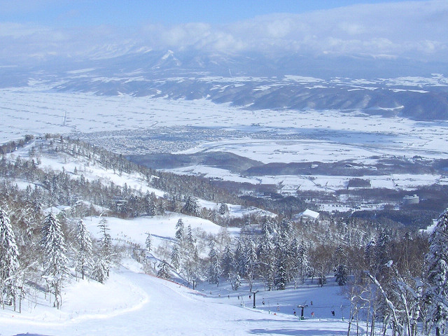
Furano ski resort is a downhill ski area in Hokkaido Prefecture, Japan. Mapped terrain includes easy, intermediate, advanced routes. Its mapped lift network extends from approximately 235 to 1064 metres above sea level.
Data: OpenSkiData / OpenSkiMap, OpenStreetMap contributors (ODbL), Skimap.org, Who's On First, Mapterhorn.
Resort cameras
Furano ski resort - Base lift station
ECMWF · Modelllauf: Nächste Aktualisierung erwartet:
Tag Uhrzeit (UTC) Temp. (°C) Luftfeuchtigkeit (%) Wind (km/h) Wind (Knoten) Wind (Bft) Richtung Niederschlag (mm) Neuschnee (cm) Luftdruck (hPa) Nullgradgrenze (m) Wetterlage | Mittwoch, 04/11 06:00 5.7 50 7 4 2B W — — 1027 1036 Clear 0% cloud 09:00 0.8 70 5 3 1B S 0 0 1027 587 Clear 1% cloud 12:00 0.7 70 7 4 2B S 0 0 1027 562 Partly cloudy 24% cloud 15:00 1 75 7 4 2B S 0 0 1026 535 Clear 8% cloud 18:00 1.6 77 8 4 2B S 0 0 1025 1717 Clear 9% cloud 21:00 1.6 72 6 4 2B S 0 0 1024 1860 Partly cloudy 47% cloud Donnerstag, 05/11 00:00 9.1 56 6 3 2B SE 0 0 1023 1877 Overcast 98% cloud 03:00 12.8 55 11 6 2B S 0 0 1018 1947 Cloudy 60% cloud 06:00 11.6 61 8 4 2B SE 0 0 1015 2095 Overcast 99% cloud 09:00 7.1 84 8 4 2B SE 0.68 0 1015 2038 Overcast 100% cloud 12:00 6.5 90 3 1 1B SE 2.1 0 1011 2135 Overcast 100% cloud 15:00 6.6 90 5 3 1B E 5.3 0 1006 2348 Overcast 100% cloud 18:00 7.1 92 3 2 1B SE 6.0 0 1001 2436 Overcast 100% cloud 21:00 6.9 93 3 1 1B NW 4.8 0 1000 2282 Overcast 100% cloud Freitag, 06/11 00:00 8.7 87 4 2 1B NW 0.96 0 999 2016 Cloudy 63% cloud 03:00 11.7 61 14 8 3B W 0.07 0 998 1714 Cloudy 56% cloud 06:00 11.4 59 7 4 2B W 0.04 0 998 1755 Clear 14% cloud 09:00 8.1 79 13 7 3B SW 0.19 0 998 1617 Cloudy 68% cloud 12:00 4.6 87 16 9 3B W 1.1 0 1002 923 Overcast 84% cloud 15:00 1.7 84 17 9 3B W 0.62 0 1003 529 Cloudy 76% cloud 18:00 -0.6 73 18 10 3B SW 0.61 0.2 1003 < 494 Cloudy 56% cloud 21:00 -1.6 68 20 11 3B SW 0.69 0.2 1003 < 494 Cloudy 74% cloud Samstag, 07/11 00:00 -0.4 61 24 13 4B SW 0.55 0.2 1003 < 494 Cloudy 77% cloud 03:00 -0.1 65 23 13 4B W 1.3 0.4 1003 < 494 Overcast 89% cloud 06:00 -1.1 75 20 11 4B W 1.7 0.5 1003 < 494 Overcast 91% cloud 09:00 -1.1 82 22 12 4B W 1.7 0.5 1005 < 494 Overcast 92% cloud 12:00 -0.9 82 25 13 4B W 1.7 0.5 1008 < 494 Overcast 97% cloud 15:00 -0.9 82 23 12 4B W 1.8 0.5 1011 < 494 Overcast 98% cloud 18:00 -0.8 82 21 11 4B W 1.1 0.3 1014 < 494 Overcast 98% cloud 21:00 -0.7 83 15 8 3B W 0.50 0.2 1017 < 494 Overcast 97% cloud Sonntag, 08/11 00:00 0.2 79 18 10 3B W 0.55 0.2 1020 < 494 Overcast 92% cloud 03:00 1.2 72 20 11 4B W 0.76 0 1022 < 494 Overcast 97% cloud 06:00 0.4 75 15 8 3B W 0.68 0.2 1024 < 494 Overcast 91% cloud 09:00 -1 84 11 6 2B W 0.47 0.1 1026 < 494 Overcast 82% cloud 12:00 -1.4 84 9 5 2B W 0.21 0 1027 < 494 Overcast 84% cloud 15:00 -1.9 82 12 6 2B W 0.25 0.1 1027 < 494 Overcast 85% cloud 18:00 -2.4 81 11 6 2B W 0.22 0 1026 < 494 Cloudy 76% cloud 21:00 -2.9 80 11 6 2B W 0.26 0.3 1027 < 494 Cloudy 67% cloud Montag, 09/11 00:00 -1.8 72 14 7 3B W 0.22 0 1027 < 494 Cloudy 75% cloud 03:00 -1.3 62 15 8 3B W 0.61 0.2 1025 < 494 Cloudy 71% cloud 06:00 -2.6 66 11 6 2B W 0.37 0.1 1024 < 494 Cloudy 72% cloud 09:00 -5.9 78 2 1 1B W 0.08 0.1 1024 < 494 Cloudy 69% cloud 12:00 -6.7 79 1 1 1B NW 0.48 0.5 1023 < 494 Overcast 91% cloud 15:00 -7.5 81 1 0 0B NE 0.60 0.6 1022 < 494 Cloudy 71% cloud 18:00 -9 83 2 1 1B NW 0.12 0.1 1022 < 494 Cloudy 77% cloud 21:00 -9.2 79 3 1 1B NW 0.09 0.1 1024 < 494 Partly cloudy 37% cloud Dienstag, 10/11 00:00 -4 59 6 3 2B NW 0 0 1026 < 494 Cloudy 59% cloud 03:00 -1.1 59 11 6 2B NW 0 0 1025 < 494 Cloudy 55% cloud 06:00 -1.3 68 7 4 2B NW 0.03 0 1026 < 494 Overcast 91% cloud |
|---|
Forecast notes
Forecast table times: UTC.
Coordinates: 43.3439024°N, 142.3601123°E · Requested elevation: 235 m. Model terrain: 491 m. Terrain and 1000/925/850/700 hPa profiles are used for height estimates.
Outside the available profile, temperature uses an estimated 5.5°C/km height correction; wind retains the nearest available model-level value. Humidity is estimated with adjusted pressure and temperature.
These are altitude estimates, not a simulation of local mountain terrain. Precipitation, cloud and sea-level pressure use horizontal interpolation only.
Precipitation includes rain and snow water equivalent: preceding 3 hours through day 6, then 6 hours (see cell tooltip). Snow (cm) estimates fresh snowfall from precipitation and temperature using the GFS conversion; it is not snow depth on the ground. Freezing (m) uses additional 600/500 hPa temperatures when available and estimates the lowest resolved 0°C crossing above sea level. When all sampled levels are warm, the upper profile limit is shown (see tooltip). < marks an entirely cold sampled profile and its lower height limit. No extrapolation is used.
Source: ECMWF · CC BY 4.0 · Processed by Snow Report.
Furano ski resort - Top lift station
ECMWF · Modelllauf: Nächste Aktualisierung erwartet:
Tag Uhrzeit (UTC) Temp. (°C) Luftfeuchtigkeit (%) Wind (km/h) Wind (Knoten) Wind (Bft) Richtung Niederschlag (mm) Neuschnee (cm) Luftdruck (hPa) Nullgradgrenze (m) Wetterlage | Mittwoch, 04/11 06:00 -0.2 47 20 11 4B W — — 1027 1031 Clear 0% cloud 09:00 1.1 47 28 15 4B SW 0 0 1027 638 Clear 1% cloud 12:00 2.2 41 36 19 5B SW 0 0 1027 590 Partly cloudy 22% cloud 15:00 2.3 45 31 17 5B SW 0 0 1026 570 Clear 8% cloud 18:00 2.9 42 34 18 5B SW 0 0 1025 1715 Clear 9% cloud 21:00 3.6 42 31 17 5B SW 0 0 1024 1865 Partly cloudy 45% cloud Donnerstag, 05/11 00:00 4.5 48 36 19 5B S 0 0 1022 1879 Overcast 98% cloud 03:00 5.8 72 27 15 4B S 0 0 1018 1941 Cloudy 59% cloud 06:00 6.2 80 23 12 4B S 0 0 1015 2099 Overcast 99% cloud 09:00 5.5 80 23 12 4B S 0.71 0 1015 2040 Overcast 100% cloud 12:00 5.6 81 14 8 3B SE 2.3 0 1011 2137 Overcast 100% cloud 15:00 6.2 84 25 14 4B SE 5.4 0 1006 2365 Overcast 100% cloud 18:00 5.4 98 30 16 5B SE 6.0 0 1001 2430 Overcast 100% cloud 21:00 4.4 100 9 5 2B S 5.0 0 1000 2278 Overcast 100% cloud Freitag, 06/11 00:00 4.3 91 22 12 4B NW 0.91 0 999 2005 Cloudy 63% cloud 03:00 4.5 82 26 14 4B W 0.04 0 998 1721 Partly cloudy 49% cloud 06:00 4.9 71 27 14 4B W 0.02 0 998 1760 Clear 15% cloud 09:00 3.3 90 45 24 6B SW 0.20 0 998 1606 Cloudy 75% cloud 12:00 -1.1 90 48 26 6B W 1.0 0.3 1002 912 Overcast 87% cloud 15:00 -4 92 51 28 7B W 0.63 0.6 1003 < 535 Overcast 80% cloud 18:00 -6.7 85 55 30 7B W 0.66 0.7 1003 < 535 Cloudy 62% cloud 21:00 -7.8 84 56 30 7B W 0.80 0.8 1003 < 535 Cloudy 78% cloud Samstag, 07/11 00:00 -7.5 82 57 31 7B W 0.55 0.5 1003 < 535 Cloudy 77% cloud 03:00 -7 82 62 33 7B W 1.3 1.3 1003 < 535 Overcast 91% cloud 06:00 -7.2 86 65 35 8B W 1.9 1.9 1004 < 535 Overcast 93% cloud 09:00 -6.7 89 67 36 8B W 2.0 2 1005 < 535 Overcast 93% cloud 12:00 -6.6 92 72 39 8B W 2.0 2 1008 < 535 Overcast 98% cloud 15:00 -6.6 92 69 37 8B W 2.1 2.1 1011 < 535 Overcast 99% cloud 18:00 -6.4 93 66 35 8B W 1.2 1.2 1014 < 535 Overcast 98% cloud 21:00 -6.2 94 56 30 7B W 0.60 0.6 1017 < 535 Overcast 98% cloud Sonntag, 08/11 00:00 -6 94 51 27 7B W 0.63 0.6 1020 < 535 Overcast 93% cloud 03:00 -5.6 92 44 24 6B W 0.78 0.8 1022 < 535 Overcast 97% cloud 06:00 -6 93 42 22 6B W 0.70 0.7 1024 < 535 Overcast 94% cloud 09:00 -6.5 93 39 21 6B W 0.55 0.5 1026 < 535 Overcast 85% cloud 12:00 -6.8 93 34 19 5B W 0.27 0.3 1027 < 535 Overcast 87% cloud 15:00 -7.6 92 39 21 5B W 0.31 0.3 1027 < 535 Overcast 88% cloud 18:00 -7.9 89 41 22 6B W 0.28 0.3 1027 < 535 Overcast 81% cloud 21:00 -8.6 87 37 20 5B W 0.28 0.3 1027 < 535 Cloudy 73% cloud Montag, 09/11 00:00 -8.8 88 37 20 5B W 0.28 0.3 1027 < 535 Overcast 81% cloud 03:00 -8.7 77 35 19 5B W 0.68 0.7 1025 < 535 Cloudy 75% cloud 06:00 -9.3 80 28 15 4B W 0.46 0.5 1024 < 535 Cloudy 78% cloud 09:00 -9.9 78 19 10 3B W 0.09 0.1 1024 < 535 Cloudy 76% cloud 12:00 -10.4 84 18 10 3B NW 0.47 0.5 1023 < 535 Overcast 90% cloud 15:00 -10.6 78 11 6 2B N 0.45 0.4 1022 < 535 Cloudy 69% cloud 18:00 -11.1 76 18 10 3B N 0.12 0.1 1022 < 535 Cloudy 80% cloud 21:00 -11.1 70 26 14 4B N 0.10 0.1 1024 < 535 Partly cloudy 41% cloud Dienstag, 10/11 00:00 -10.3 66 33 18 5B NW 0 0 1026 < 535 Cloudy 56% cloud 03:00 -8.1 79 31 17 5B N 0 0 1025 < 535 Cloudy 66% cloud 06:00 -7.4 87 26 14 4B NW 0.03 0 1026 < 535 Overcast 95% cloud |
|---|
Forecast notes
Forecast table times: UTC.
Coordinates: 43.3243154°N, 142.3192504°E · Requested elevation: 1064 m. Model terrain: 533 m. Terrain and 1000/925/850/700 hPa profiles are used for height estimates.
These are altitude estimates, not a simulation of local mountain terrain. Precipitation, cloud and sea-level pressure use horizontal interpolation only.
Precipitation includes rain and snow water equivalent: preceding 3 hours through day 6, then 6 hours (see cell tooltip). Snow (cm) estimates fresh snowfall from precipitation and temperature using the GFS conversion; it is not snow depth on the ground. Freezing (m) uses additional 600/500 hPa temperatures when available and estimates the lowest resolved 0°C crossing above sea level. When all sampled levels are warm, the upper profile limit is shown (see tooltip). < marks an entirely cold sampled profile and its lower height limit. No extrapolation is used.