Προγνώσεις για χιονοδρομικά σε όλο τον κόσμο

Περισσότερα
Χρωματική κλίμακα Θερμοκρασία · Άνεμος · Βροχή · Χιόνι
Κάθε χρώμα ξεκινά από την τιμή που αναγράφεται. Τα χρώματα ανέμου αντιστοιχούν και στις τρεις μονάδες. Οι τιμές χωρίς υετό παραμένουν ουδέτερες. Τα χρώματα περιγράφουν τις τιμές και δεν αποτελούν επίσημες προειδοποιήσεις.
Familienschiberg St. Jakob im Walde - Base lift station
ECMWF · Εκτέλεση μοντέλου: Αναμενόμενη επόμενη ενημέρωση:
Ημέρα Ώρα (UTC) Θερμ. (°C) Υγρασία (%) Άνεμος (km/h) Άνεμος (κόμβοι) Άνεμος (Bft) Διεύθυνση Υετός (mm) Νέο χιόνι (cm) Πίεση (hPa) Σημείο παγοποίησης (m) Συνθήκες | Τετάρτη, 04/11 06:00 0.5 96 6 3 1B N — — 1029 1255 Overcast 100% cloud  09:00 2.9 83 1 1 1B NE 0 0 1030 1440 Overcast 100% cloud 12:00 4.4 78 4 2 1B S 0 0 1029 1448 Overcast 100% cloud 15:00 3.5 83 4 2 1B SE 0.05 0 1030 1412 Overcast 100% cloud 18:00 1.9 88 2 1 1B SE 0.05 0 1031 1324 Overcast 99% cloud 21:00 -0.2 93 1 0 0B SW 0 0 1032 < 1001 Clear 8% cloud  Πέμπτη, 05/11 00:00 -1.1 94 2 1 1B S 0 0 1032 < 1001 Partly cloudy 44% cloud  03:00 -1.2 96 4 2 1B S 0 0 1032 < 1001 Overcast 82% cloud 06:00 0.4 96 5 3 1B S 0 0 1032 1187 Overcast 99% cloud 09:00 2.4 86 8 5 2B S 0 0 1033 1892 Overcast 95% cloud 12:00 4.6 72 9 5 2B S 0 0 1031 2243 Cloudy 69% cloud  15:00 3.2 82 7 4 2B S 0 0 1030 2761 Partly cloudy 39% cloud 18:00 -0.3 97 4 2 1B S 0 0 1030 1059 Partly cloudy 23% cloud 21:00 -0.9 96 4 2 1B SW 0 0 1030 1109 Overcast 85% cloud Παρασκευή, 06/11 00:00 -0.7 98 5 3 1B W 0 0 1028 1069 Overcast 87% cloud 03:00 -1.2 96 3 1 1B W 0 0 1027 1103 Overcast 87% cloud 06:00 -1.7 97 2 1 1B SW 0 0 1026 1141 Overcast 82% cloud 09:00 4.7 76 5 3 1B S 0 0 1027 2886 Clear 0% cloud 12:00 7.6 56 6 3 2B S 0 0 1024 2833 Clear 0% cloud 15:00 4.5 71 4 2 1B SE 0 0 1025 2820 Clear 0% cloud 18:00 -0.1 87 2 1 1B SE 0 0 1025 1025 Clear 0% cloud 21:00 -0.9 87 2 1 1B SE 0 0 1026 1125 Clear 0% cloud Σάββατο, 07/11 00:00 -1.5 89 3 2 1B S 0 0 1027 1237 Clear 0% cloud 03:00 -1.7 92 4 2 1B S 0 0 1027 1324 Partly cloudy 35% cloud 06:00 -2.2 94 4 2 1B S 0 0 1029 1316 Partly cloudy 34% cloud 09:00 3 65 7 4 2B S 0 0 1029 1907 Clear 1% cloud 12:00 5.4 55 9 5 2B S 0 0 1027 1792 Clear 0% cloud 15:00 1.8 71 4 2 1B S 0 0 1027 2138 Clear 0% cloud 18:00 -1.7 83 3 2 1B S 0 0 1028 1215 Clear 0% cloud 21:00 -2.5 90 4 2 1B S 0 0 1029 1260 Clear 0% cloud Κυριακή, 08/11 00:00 -3.1 91 3 2 1B SW 0 0 1028 1267 Clear 0% cloud 03:00 -3.4 87 3 1 1B W 0 0 1027 1297 Partly cloudy 36% cloud 06:00 -3.2 81 3 2 1B SW 0 0 1027 1323 Partly cloudy 49% cloud 09:00 3.2 49 7 4 2B S 0 0 1027 1971 Clear 0% cloud 12:00 5.4 51 8 4 2B S 0 0 1025 1961 Clear 1% cloud 15:00 1.2 80 4 2 1B S 0 0 1026 1938 Clear 16% cloud 18:00 -1.5 90 3 1 1B W 0 0 1026 1181 Clear 0% cloud 21:00 -1.6 90 3 2 1B W 0 0 1026 1182 Clear 0% cloud Δευτέρα, 09/11 00:00 -1.6 89 3 2 1B W 0 0 1025 1170 Clear 0% cloud 03:00 -1.3 86 3 1 1B NW 0 0 1024 1137 Clear 0% cloud 06:00 -1.2 84 2 1 1B W 0 0 1023 1120 Clear 9% cloud 09:00 6 58 4 2 1B SW 0 0 1023 2416 Partly cloudy 42% cloud 12:00 8.4 51 5 3 1B SW 0 0 1020 2482 Overcast 94% cloud 15:00 3.5 79 4 2 1B SW 0.09 0 1020 2542 Cloudy 71% cloud 18:00 1 89 3 2 1B W 0 0 1019 2736 Partly cloudy 36% cloud 21:00 0.9 85 5 3 1B W 0 0 1018 2763 Partly cloudy 47% cloud Τρίτη, 10/11 00:00 0.9 86 7 4 2B W 0 0 1016 2856 Cloudy 68% cloud 03:00 1.7 88 7 4 2B NW 0 0 1014 2948 Overcast 100% cloud 06:00 2.4 86 6 3 2B NW 0.11 0 1014 2931 Overcast 99% cloud |
|---|
Forecast notes
Forecast table times: UTC.
Coordinates: 47.4774454°N, 15.7884852°E · Requested elevation: 1008 m. Model terrain: 999 m. Terrain and 1000/925/850/700 hPa profiles are used for height estimates.
These are altitude estimates, not a simulation of local mountain terrain. Precipitation, cloud and sea-level pressure use horizontal interpolation only.
Precipitation includes rain and snow water equivalent: preceding 3 hours through day 6, then 6 hours (see cell tooltip). Snow (cm) estimates fresh snowfall from precipitation and temperature using the GFS conversion; it is not snow depth on the ground. Freezing (m) uses additional 600/500 hPa temperatures when available and estimates the lowest resolved 0°C crossing above sea level. When all sampled levels are warm, the upper profile limit is shown (see tooltip). < marks an entirely cold sampled profile and its lower height limit. No extrapolation is used.
Source: ECMWF · CC BY 4.0 · Processed by Snow Report.
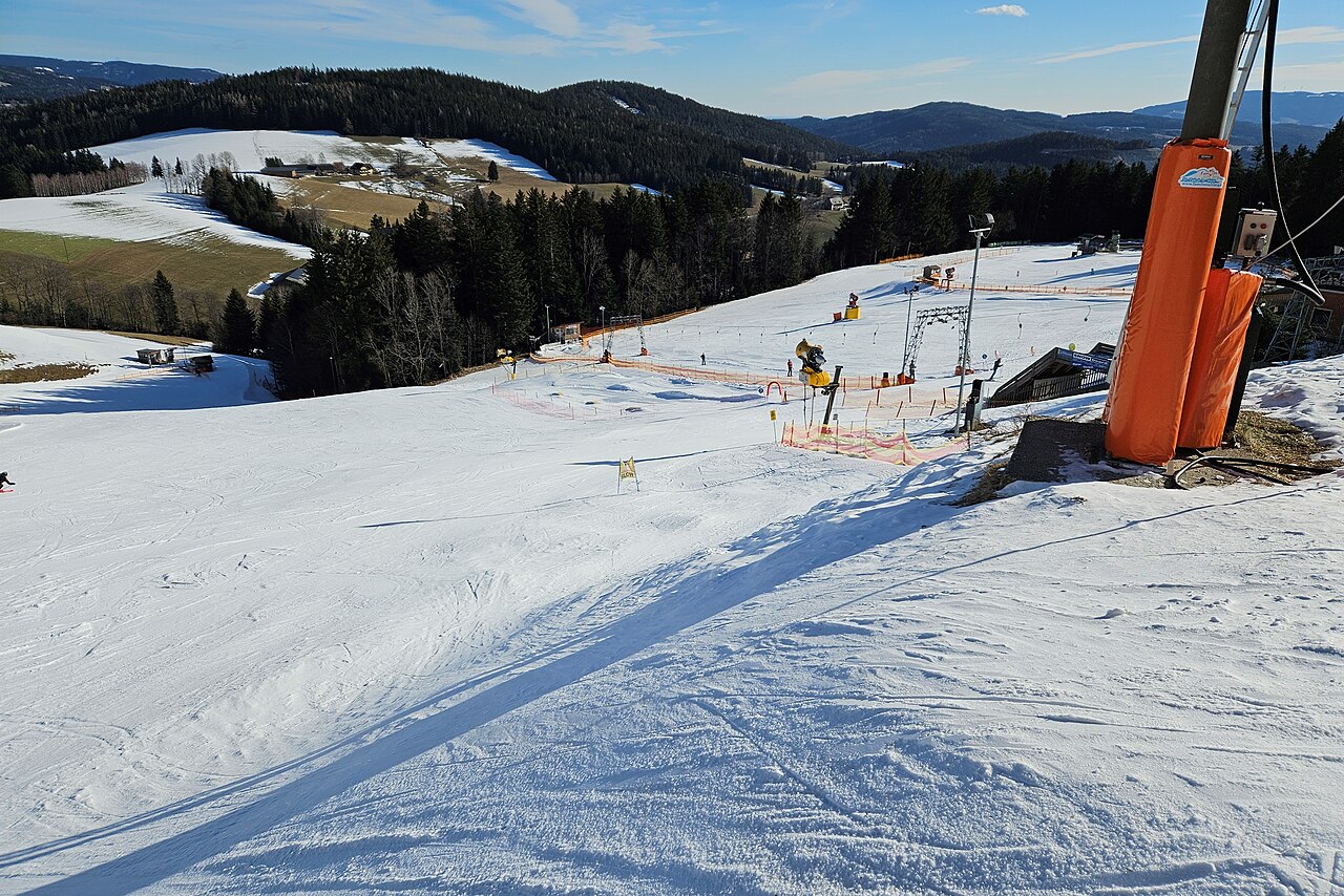
Familienschiberg St. Jakob im Walde is a mapped downhill ski area in AT. Forecasts cover three real lift-station locations from approximately 1008 to 1190 metres. Elevations are terrain-model estimates.
Data: OpenSkiData / OpenSkiMap, OpenStreetMap contributors (ODbL), Skimap.org, Who's On First, Mapterhorn.
Familienschiberg St. Jakob im Walde - Middle lift station
ECMWF · Εκτέλεση μοντέλου: Αναμενόμενη επόμενη ενημέρωση:
Ημέρα Ώρα (UTC) Θερμ. (°C) Υγρασία (%) Άνεμος (km/h) Άνεμος (κόμβοι) Άνεμος (Bft) Διεύθυνση Υετός (mm) Νέο χιόνι (cm) Πίεση (hPa) Σημείο παγοποίησης (m) Συνθήκες | Τετάρτη, 04/11 06:00 0.4 97 5 3 1B N — — 1029 1255 Overcast 100% cloud 09:00 2.5 84 1 0 0B NE 0 0 1030 1440 Overcast 100% cloud 12:00 3.8 80 3 2 1B S 0 0 1029 1449 Overcast 100% cloud 15:00 3 84 4 2 1B SE 0.05 0 1029 1412 Overcast 100% cloud 18:00 1.5 89 3 2 1B SE 0.05 0 1031 1324 Overcast 99% cloud 21:00 -0.2 91 2 1 1B SE 0 0 1032 < 1003 Clear 8% cloud Πέμπτη, 05/11 00:00 -1.2 93 3 2 1B S 0 0 1032 < 1003 Partly cloudy 45% cloud 03:00 -1.2 94 5 3 1B S 0 0 1032 < 1003 Overcast 82% cloud 06:00 0.3 95 7 4 2B S 0 0 1032 1184 Overcast 99% cloud 09:00 2.2 84 10 5 2B S 0 0 1033 1880 Overcast 96% cloud 12:00 4.2 72 10 5 2B S 0 0 1031 2233 Cloudy 70% cloud 15:00 3.1 79 8 4 2B S 0 0 1030 2760 Partly cloudy 39% cloud 18:00 0.1 91 5 3 1B S 0 0 1030 1062 Partly cloudy 23% cloud 21:00 -0.4 89 5 3 1B SW 0 0 1030 1111 Overcast 86% cloud Παρασκευή, 06/11 00:00 -0 88 5 3 1B W 0 0 1028 1071 Overcast 87% cloud 03:00 -0.4 86 3 2 1B SW 0 0 1027 1105 Overcast 88% cloud 06:00 -1 88 3 1 1B SW 0 0 1026 1143 Overcast 83% cloud 09:00 4.7 71 6 3 2B S 0 0 1027 2887 Clear 0% cloud 12:00 7.2 54 7 4 2B S 0 0 1024 2833 Clear 0% cloud 15:00 4.5 65 5 3 1B SE 0 0 1025 2820 Clear 0% cloud 18:00 0.4 78 4 2 1B SE 0 0 1025 1028 Clear 0% cloud 21:00 -0.4 78 5 3 1B SE 0 0 1026 1128 Clear 0% cloud Σάββατο, 07/11 00:00 -1.1 80 6 3 2B S 0 0 1027 1239 Clear 0% cloud 03:00 -1.4 82 7 4 2B S 0 0 1027 1327 Partly cloudy 35% cloud 06:00 -1.8 83 7 4 2B S 0 0 1029 1318 Partly cloudy 34% cloud 09:00 2.7 64 10 6 2B S 0 0 1029 1900 Clear 1% cloud 12:00 4.8 55 10 6 2B S 0 0 1027 1786 Clear 0% cloud 15:00 1.8 64 6 3 2B S 0 0 1027 2136 Clear 0% cloud 18:00 -1.2 71 6 3 2B S 0 0 1028 1217 Clear 0% cloud 21:00 -1.9 77 7 4 2B S 0 0 1029 1261 Clear 0% cloud Κυριακή, 08/11 00:00 -2.4 77 6 3 1B S 0 0 1028 1269 Clear 0% cloud 03:00 -2.7 74 5 3 1B SW 0 0 1027 1299 Partly cloudy 36% cloud 06:00 -2.6 71 6 3 1B SW 0 0 1027 1325 Partly cloudy 49% cloud 09:00 3 49 9 5 2B S 0 0 1027 1968 Clear 0% cloud 12:00 5.1 52 9 5 2B S 0 0 1025 1959 Clear 1% cloud 15:00 1.3 78 5 3 1B SW 0 0 1026 1937 Clear 16% cloud 18:00 -1 87 4 2 1B W 0 0 1026 1183 Clear 0% cloud 21:00 -1 86 4 2 1B W 0 0 1026 1183 Clear 0% cloud Δευτέρα, 09/11 00:00 -1 85 4 2 1B W 0 0 1025 1172 Clear 0% cloud 03:00 -0.7 82 3 2 1B W 0 0 1024 1139 Clear 0% cloud 06:00 -0.6 79 3 1 1B W 0 0 1023 1122 Clear 10% cloud 09:00 5.9 56 5 3 1B SW 0 0 1023 2416 Partly cloudy 42% cloud 12:00 8 50 6 3 2B SW 0 0 1020 2482 Overcast 94% cloud 15:00 3.7 73 5 3 1B SW 0.10 0 1020 2541 Cloudy 71% cloud 18:00 1.6 82 5 3 1B SW 0 0 1019 2736 Partly cloudy 35% cloud 21:00 1.8 76 6 3 2B W 0 0 1018 2762 Partly cloudy 47% cloud Τρίτη, 10/11 00:00 2 77 9 5 2B W 0 0 1016 2856 Cloudy 68% cloud 03:00 2.6 82 8 5 2B NW 0 0 1014 2949 Overcast 100% cloud 06:00 3.4 79 7 4 2B W 0.11 0 1014 2932 Overcast 99% cloud |
|---|
Forecast notes
Forecast table times: UTC.
Coordinates: 47.4770566°N, 15.7848972°E · Requested elevation: 1069 m. Model terrain: 1000 m. Terrain and 1000/925/850/700 hPa profiles are used for height estimates.
These are altitude estimates, not a simulation of local mountain terrain. Precipitation, cloud and sea-level pressure use horizontal interpolation only.
Precipitation includes rain and snow water equivalent: preceding 3 hours through day 6, then 6 hours (see cell tooltip). Snow (cm) estimates fresh snowfall from precipitation and temperature using the GFS conversion; it is not snow depth on the ground. Freezing (m) uses additional 600/500 hPa temperatures when available and estimates the lowest resolved 0°C crossing above sea level. When all sampled levels are warm, the upper profile limit is shown (see tooltip). < marks an entirely cold sampled profile and its lower height limit. No extrapolation is used.
Source: ECMWF · CC BY 4.0 · Processed by Snow Report.
Familienschiberg St. Jakob im Walde - Top lift station
ECMWF · Εκτέλεση μοντέλου: Αναμενόμενη επόμενη ενημέρωση:
Ημέρα Ώρα (UTC) Θερμ. (°C) Υγρασία (%) Άνεμος (km/h) Άνεμος (κόμβοι) Άνεμος (Bft) Διεύθυνση Υετός (mm) Νέο χιόνι (cm) Πίεση (hPa) Σημείο παγοποίησης (m) Συνθήκες | Τετάρτη, 04/11 06:00 0.1 98 4 2 1B N — — 1029 1243 Overcast 100% cloud 09:00 1.7 88 1 0 0B SE 0 0 1030 1441 Overcast 100% cloud 12:00 2.6 85 3 2 1B S 0 0 1029 1450 Overcast 100% cloud 15:00 1.9 88 4 2 1B E 0.05 0 1029 1413 Overcast 100% cloud 18:00 0.8 91 5 3 1B SE 0.05 0 1031 1325 Overcast 99% cloud 21:00 -0.4 89 5 3 1B SE 0 0 1032 < 1011 Clear 7% cloud Πέμπτη, 05/11 00:00 -1.3 91 6 3 2B SE 0 0 1032 < 1011 Partly cloudy 45% cloud 03:00 -1.1 91 9 5 2B S 0 0 1032 < 1011 Overcast 83% cloud 06:00 -0 92 10 5 2B S 0 0 1032 1175 Overcast 99% cloud 09:00 1.8 81 12 6 2B S 0 0 1033 1879 Overcast 96% cloud 12:00 3.4 73 12 7 2B S 0 0 1031 2229 Cloudy 70% cloud 15:00 3 73 10 6 2B S 0 0 1030 2759 Partly cloudy 40% cloud 18:00 0.7 80 8 4 2B S 0 0 1030 1078 Partly cloudy 23% cloud 21:00 0.7 76 8 5 2B SW 0 0 1030 1123 Overcast 87% cloud Παρασκευή, 06/11 00:00 1.3 72 7 4 2B SW 0 0 1029 1081 Overcast 89% cloud 03:00 1 69 7 4 2B SW 0 0 1027 1113 Overcast 89% cloud 06:00 0.6 71 5 3 1B S 0 0 1026 1149 Overcast 84% cloud 09:00 4.6 62 9 5 2B S 0 0 1027 2887 Clear 0% cloud 12:00 6.3 50 8 4 2B S 0 0 1024 2832 Clear 0% cloud 15:00 4.4 55 8 4 2B SE 0 0 1025 2820 Clear 0% cloud 18:00 1.3 63 8 4 2B SE 0 0 1025 1043 Clear 0% cloud 21:00 0.4 63 10 5 2B SE 0 0 1026 1141 Clear 0% cloud Σάββατο, 07/11 00:00 -0.4 64 12 6 2B S 0 0 1027 1249 Clear 0% cloud 03:00 -0.8 64 13 7 3B S 0 0 1027 1333 Partly cloudy 36% cloud 06:00 -1 65 13 7 3B S 0 0 1029 1324 Partly cloudy 35% cloud 09:00 2.2 61 16 9 3B S 0 0 1029 1896 Clear 1% cloud 12:00 3.7 55 13 7 3B S 0 0 1027 1781 Clear 0% cloud 15:00 1.8 51 11 6 2B S 0 0 1027 2134 Clear 0% cloud 18:00 -0.3 52 12 7 2B S 0 0 1028 1226 Clear 0% cloud 21:00 -0.8 55 13 7 3B S 0 0 1029 1269 Clear 0% cloud Κυριακή, 08/11 00:00 -1 54 12 7 2B S 0 0 1028 1276 Clear 0% cloud 03:00 -1.4 52 12 6 2B S 0 0 1027 1304 Partly cloudy 37% cloud 06:00 -1.4 53 12 6 2B S 0 0 1027 1330 Partly cloudy 50% cloud 09:00 2.7 47 14 8 3B S 0 0 1027 1967 Clear 0% cloud 12:00 4.3 53 13 7 3B SW 0 0 1025 1956 Clear 1% cloud 15:00 1.6 75 8 4 2B SW 0 0 1026 1936 Clear 17% cloud 18:00 0 81 8 4 2B SW 0 0 1026 1191 Clear 0% cloud 21:00 0 79 7 4 2B W 0 0 1026 1191 Clear 0% cloud Δευτέρα, 09/11 00:00 0.1 77 7 4 2B W 0 0 1025 1179 Clear 0% cloud 03:00 0.5 73 5 3 1B W 0 0 1024 1146 Clear 0% cloud 06:00 0.7 69 4 2 1B SW 0 0 1023 1130 Clear 9% cloud 09:00 5.6 52 8 4 2B SW 0 0 1023 2416 Partly cloudy 42% cloud 12:00 7.3 47 8 4 2B SW 0 0 1020 2481 Overcast 94% cloud 15:00 4.2 63 6 3 2B SW 0.10 0 1020 2539 Cloudy 71% cloud 18:00 2.8 70 9 5 2B SW 0 0 1019 2736 Partly cloudy 35% cloud 21:00 3.4 62 10 5 2B W 0 0 1018 2761 Partly cloudy 47% cloud Τρίτη, 10/11 00:00 4.2 62 14 8 3B W 0 0 1016 2855 Cloudy 67% cloud 03:00 4.4 73 11 6 2B NW 0 0 1014 2948 Overcast 100% cloud 06:00 5.3 67 11 6 2B W 0.11 0 1014 2931 Overcast 100% cloud |
|---|
Forecast notes
Forecast table times: UTC.
Coordinates: 47.4802897°N, 15.7815241°E · Requested elevation: 1190 m. Model terrain: 1009 m. Terrain and 1000/925/850/700 hPa profiles are used for height estimates.
These are altitude estimates, not a simulation of local mountain terrain. Precipitation, cloud and sea-level pressure use horizontal interpolation only.
Precipitation includes rain and snow water equivalent: preceding 3 hours through day 6, then 6 hours (see cell tooltip). Snow (cm) estimates fresh snowfall from precipitation and temperature using the GFS conversion; it is not snow depth on the ground. Freezing (m) uses additional 600/500 hPa temperatures when available and estimates the lowest resolved 0°C crossing above sea level. When all sampled levels are warm, the upper profile limit is shown (see tooltip). < marks an entirely cold sampled profile and its lower height limit. No extrapolation is used.