Wettervorhersagen für Skigebiete weltweit

Farbskala Temperatur · Wind · Regen · Schnee
Jede Farbe beginnt beim angegebenen Wert. Die Windfarben stimmen in allen drei Einheiten überein. Trockene Zellen bleiben neutral. Die Farben beschreiben die Werte und sind keine amtlichen Wetterwarnungen.
Dynaland Ski Area - Low lift station
ECMWF · Modelllauf: Nächste Aktualisierung erwartet:
Tag Uhrzeit (UTC) Temp. (°C) Luftfeuchtigkeit (%) Wind (km/h) Wind (Knoten) Wind (Bft) Richtung Niederschlag (mm) Neuschnee (cm) Luftdruck (hPa) Nullgradgrenze (m) Wetterlage | Mittwoch, 04/11 06:00 13.3 51 9 5 2B S — — 1024 3148 Overcast 98% cloud  09:00 9.4 84 3 2 1B N 0.46 0 1024 3152 Overcast 100% cloud 12:00 9.8 90 2 1 1B NE 1.5 0 1024 3144 Overcast 100% cloud 15:00 9.8 90 2 1 1B N 1.8 0 1022 3136 Overcast 100% cloud 18:00 10.3 91 1 1 0B W 0.33 0 1020 3123 Overcast 100% cloud 21:00 10.3 92 1 0 0B N 0.29 0 1018 3109 Overcast 100% cloud Donnerstag, 05/11 00:00 13.2 91 3 2 1B SW 0 0 1016 3102 Overcast 100% cloud 03:00 17.8 52 9 5 2B SW 0 0 1012 3075 Cloudy 51% cloud  06:00 17.3 56 9 5 2B SW 0.06 0 1009 3054 Cloudy 80% cloud 09:00 12 86 5 3 1B S 0.01 0 1010 3047 Overcast 96% cloud 12:00 11.5 96 5 3 1B S 1.1 0 1009 3034 Overcast 97% cloud 15:00 11.1 98 5 3 1B S 6.2 0 1007 3019 Overcast 99% cloud 18:00 10.8 98 6 3 2B SW 6.8 0 1006 3010 Overcast 100% cloud 21:00 10.8 97 8 4 2B NW 2.9 0 1009 3018 Cloudy 78% cloud Freitag, 06/11 00:00 11.5 89 9 5 2B NW 0.36 0 1012 2933 Partly cloudy 50% cloud  03:00 12.8 59 16 8 3B NW 0.25 0 1011 3008 Partly cloudy 42% cloud 06:00 10.6 77 16 9 3B W 0.73 0 1013 2821 Cloudy 68% cloud 09:00 7.4 94 13 7 3B W 0.73 0 1016 2512 Overcast 84% cloud 12:00 6.3 92 10 6 2B W 0.37 0 1018 2135 Overcast 81% cloud 15:00 5.1 95 8 4 2B NW 0.43 0 1019 1832 Cloudy 64% cloud 18:00 3.4 95 9 5 2B NW 0.37 0 1020 1479 Cloudy 64% cloud 21:00 2.7 92 8 4 2B NW 0.31 0 1022 1390 Overcast 81% cloud Samstag, 07/11 00:00 4.4 80 12 6 2B NW 0.43 0 1024 1440 Cloudy 79% cloud 03:00 5.8 64 18 10 3B NW 0.44 0 1025 1476 Cloudy 60% cloud 06:00 4.2 67 16 9 3B NW 0.31 0 1026 1395 Cloudy 54% cloud 09:00 2 79 13 7 3B N 0.12 0 1029 1240 Cloudy 79% cloud 12:00 1.5 79 13 7 3B N 0 0 1031 1189 Overcast 92% cloud 15:00 1.3 79 13 7 3B N 0.06 0 1031 1163 Overcast 92% cloud 18:00 1.1 82 14 7 3B N 0 0 1031 1150 Overcast 88% cloud 21:00 0.8 81 13 7 3B N 0 0 1032 1137 Cloudy 61% cloud Sonntag, 08/11 00:00 4.5 59 10 6 2B N 0 0 1033 3143 Cloudy 59% cloud 03:00 8.6 42 9 5 2B N 0 0 1030 2930 Partly cloudy 30% cloud 06:00 8.2 49 6 3 2B N 0 0 1029 2790 Overcast 87% cloud 09:00 3.8 73 7 4 2B N 0 0 1031 2490 Overcast 95% cloud 12:00 3.5 72 6 3 1B NE 0 0 1031 2487 Overcast 94% cloud 15:00 4.1 68 1 0 0B NE 0 0 1029 2383 Overcast 98% cloud 18:00 4.6 72 4 2 1B N 0 0 1028 2266 Overcast 100% cloud 21:00 4.3 78 4 2 1B N 0.12 0 1026 2310 Overcast 99% cloud Montag, 09/11 00:00 9.5 56 4 2 1B W 0.06 0 1026 2363 Cloudy 56% cloud 03:00 12 50 10 5 2B W 0 0 1022 2479 Partly cloudy 24% cloud 06:00 10.1 57 11 6 2B NW 0 0 1022 2320 Overcast 80% cloud 09:00 5.9 82 6 3 2B NW 0.06 0 1024 2098 Cloudy 68% cloud 12:00 4.4 92 8 4 2B N 0.06 0 1024 1998 Partly cloudy 42% cloud 15:00 3.8 86 15 8 3B N 0.06 0 1025 1673 Overcast 85% cloud 18:00 2.1 88 16 9 3B N 0 0 1025 1462 Overcast 83% cloud 21:00 0.5 88 15 8 3B N 0 0 1026 1122 Cloudy 76% cloud Dienstag, 10/11 00:00 3.8 61 14 7 3B N 0 0 1026 1431 Partly cloudy 22% cloud 03:00 7.1 48 13 7 3B N 0 0 1024 1534 Clear 16% cloud  06:00 6.3 45 10 5 2B N 0 0 1024 1719 Clear 10% cloud |
|---|
Forecast notes
Forecast table times: UTC.
Coordinates: 35.9897886°N, 136.8706044°E · Requested elevation: 984 m. Model terrain: 1058 m. Terrain and 1000/925/850/700 hPa profiles are used for height estimates.
Outside the available profile, temperature uses an estimated 5.5°C/km height correction; wind retains the nearest available model-level value. Humidity is estimated with adjusted pressure and temperature.
These are altitude estimates, not a simulation of local mountain terrain. Precipitation, cloud and sea-level pressure use horizontal interpolation only.
Precipitation includes rain and snow water equivalent: preceding 3 hours through day 6, then 6 hours (see cell tooltip). Snow (cm) estimates fresh snowfall from precipitation and temperature using the GFS conversion; it is not snow depth on the ground. Freezing (m) uses additional 600/500 hPa temperatures when available and estimates the lowest resolved 0°C crossing above sea level. When all sampled levels are warm, the upper profile limit is shown (see tooltip). < marks an entirely cold sampled profile and its lower height limit. No extrapolation is used.
Source: ECMWF · CC BY 4.0 · Processed by Snow Report.
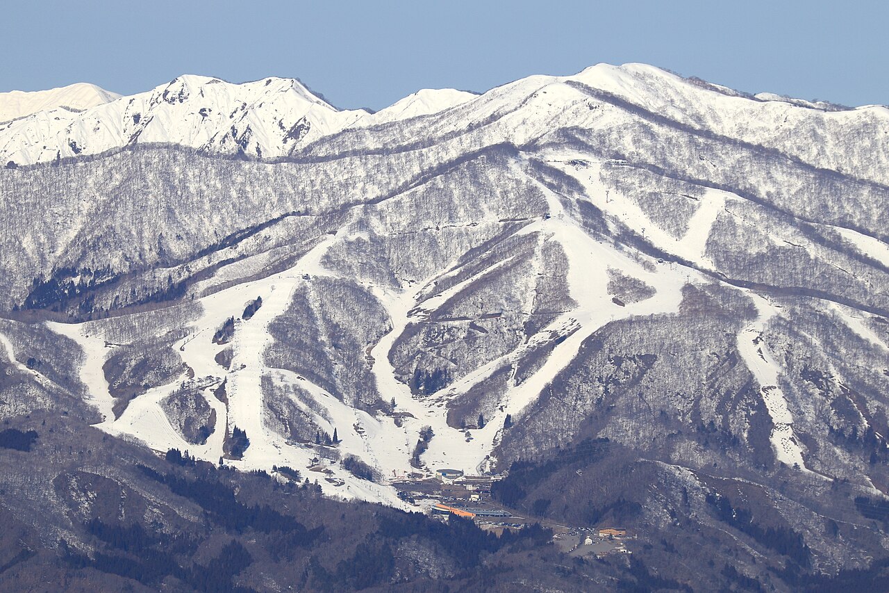
Dynaland Ski Area is a downhill ski area in Gifu Prefecture, Japan. Mapped terrain includes easy, intermediate, advanced routes. Its mapped lift network extends from approximately 984 to 1425 metres above sea level.
Data: OpenSkiData / OpenSkiMap, OpenStreetMap contributors (ODbL), Skimap.org, Who's On First, Mapterhorn.
Dynaland Ski Area - Base lift station
ECMWF · Modelllauf: Nächste Aktualisierung erwartet:
Tag Uhrzeit (UTC) Temp. (°C) Luftfeuchtigkeit (%) Wind (km/h) Wind (Knoten) Wind (Bft) Richtung Niederschlag (mm) Neuschnee (cm) Luftdruck (hPa) Nullgradgrenze (m) Wetterlage | Mittwoch, 04/11 06:00 13.3 51 9 5 2B S — — 1024 3148 Overcast 98% cloud 09:00 9.4 84 3 2 1B N 0.46 0 1024 3152 Overcast 100% cloud 12:00 9.8 90 2 1 1B NE 1.5 0 1024 3144 Overcast 100% cloud 15:00 9.8 90 2 1 1B N 1.8 0 1022 3136 Overcast 100% cloud 18:00 10.3 91 1 1 0B W 0.33 0 1020 3123 Overcast 100% cloud 21:00 10.3 92 1 0 0B N 0.29 0 1018 3109 Overcast 100% cloud Donnerstag, 05/11 00:00 13.2 91 3 2 1B SW 0 0 1016 3102 Overcast 100% cloud 03:00 17.8 52 9 5 2B SW 0 0 1012 3075 Cloudy 51% cloud 06:00 17.3 56 9 5 2B SW 0.06 0 1009 3054 Cloudy 80% cloud 09:00 12 86 5 3 1B S 0.01 0 1010 3047 Overcast 96% cloud 12:00 11.5 96 5 3 1B S 1.1 0 1009 3034 Overcast 97% cloud 15:00 11.1 98 5 3 1B S 6.2 0 1007 3019 Overcast 99% cloud 18:00 10.8 98 6 3 2B SW 6.8 0 1006 3010 Overcast 100% cloud 21:00 10.8 97 8 4 2B NW 2.9 0 1009 3018 Cloudy 78% cloud Freitag, 06/11 00:00 11.5 89 9 5 2B NW 0.36 0 1012 2933 Partly cloudy 50% cloud 03:00 12.8 59 16 8 3B NW 0.25 0 1011 3008 Partly cloudy 42% cloud 06:00 10.6 77 16 9 3B W 0.73 0 1013 2821 Cloudy 68% cloud 09:00 7.4 94 13 7 3B W 0.73 0 1016 2512 Overcast 84% cloud 12:00 6.3 92 10 6 2B W 0.37 0 1018 2135 Overcast 81% cloud 15:00 5.1 95 8 4 2B NW 0.43 0 1019 1832 Cloudy 64% cloud 18:00 3.4 95 9 5 2B NW 0.37 0 1020 1479 Cloudy 64% cloud 21:00 2.7 92 8 4 2B NW 0.31 0 1022 1390 Overcast 81% cloud Samstag, 07/11 00:00 4.4 80 12 6 2B NW 0.43 0 1024 1440 Cloudy 79% cloud 03:00 5.8 64 18 10 3B NW 0.44 0 1025 1476 Cloudy 60% cloud 06:00 4.2 67 16 9 3B NW 0.31 0 1026 1395 Cloudy 54% cloud 09:00 2 79 13 7 3B N 0.12 0 1029 1240 Cloudy 79% cloud 12:00 1.5 79 13 7 3B N 0 0 1031 1189 Overcast 92% cloud 15:00 1.3 79 13 7 3B N 0.06 0 1031 1163 Overcast 92% cloud 18:00 1.1 82 14 7 3B N 0 0 1031 1150 Overcast 88% cloud 21:00 0.8 81 13 7 3B N 0 0 1032 1137 Cloudy 61% cloud Sonntag, 08/11 00:00 4.5 59 10 6 2B N 0 0 1033 3143 Cloudy 59% cloud 03:00 8.6 42 9 5 2B N 0 0 1030 2930 Partly cloudy 30% cloud 06:00 8.2 49 6 3 2B N 0 0 1029 2790 Overcast 87% cloud 09:00 3.8 73 7 4 2B N 0 0 1031 2490 Overcast 95% cloud 12:00 3.5 72 6 3 1B NE 0 0 1031 2487 Overcast 94% cloud 15:00 4.1 68 1 0 0B NE 0 0 1029 2383 Overcast 98% cloud 18:00 4.6 72 4 2 1B N 0 0 1028 2266 Overcast 100% cloud 21:00 4.3 78 4 2 1B N 0.12 0 1026 2310 Overcast 99% cloud Montag, 09/11 00:00 9.5 56 4 2 1B W 0.06 0 1026 2363 Cloudy 56% cloud 03:00 12 50 10 5 2B W 0 0 1022 2479 Partly cloudy 24% cloud 06:00 10.1 57 11 6 2B NW 0 0 1022 2320 Overcast 80% cloud 09:00 5.9 82 6 3 2B NW 0.06 0 1024 2098 Cloudy 68% cloud 12:00 4.4 92 8 4 2B N 0.06 0 1024 1998 Partly cloudy 42% cloud 15:00 3.8 86 15 8 3B N 0.06 0 1025 1673 Overcast 85% cloud 18:00 2.1 88 16 9 3B N 0 0 1025 1462 Overcast 83% cloud 21:00 0.5 88 15 8 3B N 0 0 1026 1122 Cloudy 76% cloud Dienstag, 10/11 00:00 3.8 61 14 7 3B N 0 0 1026 1431 Partly cloudy 22% cloud 03:00 7.1 48 13 7 3B N 0 0 1024 1534 Clear 16% cloud 06:00 6.3 45 10 5 2B N 0 0 1024 1719 Clear 10% cloud |
|---|
Forecast notes
Forecast table times: UTC.
Coordinates: 35.9897886°N, 136.8706044°E · Requested elevation: 984 m. Model terrain: 1058 m. Terrain and 1000/925/850/700 hPa profiles are used for height estimates.
Outside the available profile, temperature uses an estimated 5.5°C/km height correction; wind retains the nearest available model-level value. Humidity is estimated with adjusted pressure and temperature.
These are altitude estimates, not a simulation of local mountain terrain. Precipitation, cloud and sea-level pressure use horizontal interpolation only.
Precipitation includes rain and snow water equivalent: preceding 3 hours through day 6, then 6 hours (see cell tooltip). Snow (cm) estimates fresh snowfall from precipitation and temperature using the GFS conversion; it is not snow depth on the ground. Freezing (m) uses additional 600/500 hPa temperatures when available and estimates the lowest resolved 0°C crossing above sea level. When all sampled levels are warm, the upper profile limit is shown (see tooltip). < marks an entirely cold sampled profile and its lower height limit. No extrapolation is used.
Source: ECMWF · CC BY 4.0 · Processed by Snow Report.
Dynaland Ski Area - Top lift station
ECMWF · Modelllauf: Nächste Aktualisierung erwartet:
Tag Uhrzeit (UTC) Temp. (°C) Luftfeuchtigkeit (%) Wind (km/h) Wind (Knoten) Wind (Bft) Richtung Niederschlag (mm) Neuschnee (cm) Luftdruck (hPa) Nullgradgrenze (m) Wetterlage | Mittwoch, 04/11 06:00 9.4 63 17 9 3B S — — 1024 3148 Overcast 98% cloud 09:00 8.8 88 15 8 3B S 0.44 0 1024 3152 Overcast 100% cloud 12:00 8.7 88 25 13 4B SE 1.4 0 1024 3143 Overcast 100% cloud 15:00 9.8 89 28 15 4B S 1.8 0 1022 3135 Overcast 100% cloud 18:00 10.2 95 21 11 4B S 0.34 0 1020 3123 Overcast 100% cloud 21:00 10.6 80 11 6 2B SW 0.29 0 1018 3109 Overcast 100% cloud Donnerstag, 05/11 00:00 11.5 68 11 6 2B SW 0 0 1016 3102 Overcast 100% cloud 03:00 12.8 62 11 6 2B SW 0 0 1012 3075 Cloudy 53% cloud 06:00 13 65 12 7 3B SW 0.07 0 1009 3054 Overcast 81% cloud 09:00 11.4 70 19 10 3B S 0.01 0 1010 3047 Overcast 96% cloud 12:00 10 95 29 16 5B S 1.2 0 1009 3034 Overcast 97% cloud 15:00 9.8 98 31 17 5B S 6.6 0 1007 3019 Overcast 99% cloud 18:00 9.8 99 32 17 5B W 7.1 0 1006 3010 Overcast 100% cloud 21:00 8.4 96 34 18 5B NW 3.1 0 1009 3018 Cloudy 80% cloud Freitag, 06/11 00:00 7.5 90 29 16 5B NW 0.36 0 1012 2926 Partly cloudy 50% cloud 03:00 7.5 75 30 16 5B NW 0.28 0 1012 2992 Partly cloudy 44% cloud 06:00 6.5 89 31 17 5B W 0.80 0 1013 2804 Cloudy 71% cloud 09:00 4.4 94 35 19 5B NW 0.80 0 1017 2493 Overcast 87% cloud 12:00 3.1 94 30 16 5B NW 0.42 0 1018 2121 Overcast 83% cloud 15:00 2.1 94 28 15 4B NW 0.47 0 1019 1818 Cloudy 65% cloud 18:00 0.3 93 33 18 5B NW 0.40 0.1 1020 1470 Cloudy 66% cloud 21:00 -0.3 95 31 17 5B NW 0.33 0.1 1022 1382 Overcast 84% cloud Samstag, 07/11 00:00 0.1 90 33 18 5B NW 0.47 0.1 1024 1434 Overcast 81% cloud 03:00 0.5 79 37 20 5B NW 0.47 0.1 1025 1469 Cloudy 62% cloud 06:00 -0.4 82 34 18 5B NW 0.35 0.1 1026 1388 Cloudy 55% cloud 09:00 -1.7 88 35 19 5B N 0.12 0 1029 1234 Cloudy 80% cloud 12:00 -2.1 92 34 18 5B N 0 0 1031 1186 Overcast 92% cloud 15:00 -2.4 92 35 19 5B N 0.05 0 1031 1160 Overcast 92% cloud 18:00 -2 86 40 22 6B N 0 0 1031 1148 Overcast 88% cloud 21:00 -1.6 74 35 19 5B N 0 0 1032 1135 Cloudy 63% cloud Sonntag, 08/11 00:00 1.6 46 25 13 4B N 0 0 1033 3143 Cloudy 56% cloud 03:00 3.4 51 15 8 3B N 0 0 1030 2935 Partly cloudy 28% cloud 06:00 4.1 55 9 5 2B NE 0 0 1029 2783 Overcast 88% cloud 09:00 3.4 48 4 2 1B NE 0 0 1031 2487 Overcast 95% cloud 12:00 3.6 51 9 5 2B S 0 0 1031 2486 Overcast 93% cloud 15:00 3.8 69 14 8 3B S 0 0 1029 2379 Overcast 98% cloud 18:00 4.2 57 6 3 2B W 0 0 1028 2265 Overcast 100% cloud 21:00 4.7 60 9 5 2B W 0.12 0 1026 2308 Overcast 99% cloud Montag, 09/11 00:00 5.8 63 12 6 2B W 0.05 0 1026 2356 Cloudy 53% cloud 03:00 6.8 62 13 7 3B NW 0 0 1022 2473 Partly cloudy 23% cloud 06:00 5.5 71 20 11 4B NW 0 0 1022 2311 Overcast 81% cloud 09:00 3.5 88 22 12 4B NW 0.07 0 1024 2087 Cloudy 72% cloud 12:00 3 88 25 13 4B N 0.07 0 1024 1993 Partly cloudy 44% cloud 15:00 1.2 84 33 18 5B N 0.05 0 1025 1665 Overcast 84% cloud 18:00 0.1 73 38 21 5B N 0 0 1025 1459 Overcast 83% cloud 21:00 -0.6 63 38 20 5B N 0 0 1026 1126 Cloudy 75% cloud Dienstag, 10/11 00:00 0 61 34 18 5B N 0 0 1026 1431 Partly cloudy 21% cloud 03:00 1.5 61 22 12 4B N 0 0 1024 1544 Clear 15% cloud 06:00 1.8 49 17 9 3B N 0 0 1024 1718 Clear 9% cloud |
|---|
Forecast notes
Forecast table times: UTC.
Coordinates: 35.9954758°N, 136.8552063°E · Requested elevation: 1425 m. Model terrain: 1060 m. Terrain and 1000/925/850/700 hPa profiles are used for height estimates.
These are altitude estimates, not a simulation of local mountain terrain. Precipitation, cloud and sea-level pressure use horizontal interpolation only.
Precipitation includes rain and snow water equivalent: preceding 3 hours through day 6, then 6 hours (see cell tooltip). Snow (cm) estimates fresh snowfall from precipitation and temperature using the GFS conversion; it is not snow depth on the ground. Freezing (m) uses additional 600/500 hPa temperatures when available and estimates the lowest resolved 0°C crossing above sea level. When all sampled levels are warm, the upper profile limit is shown (see tooltip). < marks an entirely cold sampled profile and its lower height limit. No extrapolation is used.