Προγνώσεις για χιονοδρομικά σε όλο τον κόσμο

Περισσότερα
Χρωματική κλίμακα Θερμοκρασία · Άνεμος · Βροχή · Χιόνι
Κάθε χρώμα ξεκινά από την τιμή που αναγράφεται. Τα χρώματα ανέμου αντιστοιχούν και στις τρεις μονάδες. Οι τιμές χωρίς υετό παραμένουν ουδέτερες. Τα χρώματα περιγράφουν τις τιμές και δεν αποτελούν επίσημες προειδοποιήσεις.
Bad gastein - βάση
ECMWF · Εκτέλεση μοντέλου: Αναμενόμενη επόμενη ενημέρωση:
Ημέρα Ώρα (UTC) Θερμ. (°C) Υγρασία (%) Άνεμος (km/h) Άνεμος (κόμβοι) Άνεμος (Bft) Διεύθυνση Υετός (mm) Νέο χιόνι (cm) Πίεση (hPa) Σημείο παγοποίησης (m) Συνθήκες | Τετάρτη, 04/11 06:00 1.3 78 2 1 1B SE — — 1026 < 1738 Overcast 99% cloud  09:00 4.6 71 3 2 1B SE 0.11 0 1027 1923 Overcast 99% cloud 12:00 6.6 66 3 2 1B SE 0.13 0 1026 2198 Cloudy 69% cloud  15:00 5.7 69 4 2 1B SE 0.03 0 1025 2157 Cloudy 63% cloud 18:00 3 75 4 2 1B SE 0.03 0 1027 < 1738 Cloudy 69% cloud 21:00 2.2 75 4 2 1B S 0 0 1029 < 1738 Cloudy 79% cloud Πέμπτη, 05/11 00:00 0.9 74 3 2 1B S 0 0 1029 < 1738 Cloudy 77% cloud 03:00 -0.4 76 3 2 1B S 0 0 1028 < 1738 Cloudy 75% cloud 06:00 -1.5 74 3 1 1B S 0 0 1027 < 1738 Cloudy 64% cloud 09:00 6.2 58 3 2 1B S 0 0 1027 2808 Clear 10% cloud  12:00 9.7 49 3 2 1B S 0 0 1025 3042 Clear 2% cloud 15:00 7.1 59 2 1 1B S 0 0 1024 3095 Clear 1% cloud 18:00 1.8 68 2 1 1B S 0 0 1024 3009 Clear 0% cloud 21:00 1 62 2 1 1B S 0 0 1024 3016 Clear 1% cloud Παρασκευή, 06/11 00:00 0.7 59 1 1 1B S 0 0 1023 3015 Clear 1% cloud 03:00 0.6 57 1 1 1B S 0 0 1022 2932 Clear 1% cloud 06:00 0.5 55 1 1 1B S 0 0 1021 2878 Clear 1% cloud 09:00 8.7 45 2 1 1B S 0 0 1021 3106 Clear 2% cloud 12:00 11.3 40 2 1 1B S 0 0 1019 3098 Clear 3% cloud 15:00 7.4 55 3 1 1B SE 0 0 1019 3093 Clear 2% cloud 18:00 2.1 66 3 2 1B S 0 0 1021 < 1738 Clear 1% cloud 21:00 1 63 3 2 1B S 0 0 1022 < 1738 Clear 0% cloud Σάββατο, 07/11 00:00 0.5 62 3 2 1B S 0 0 1023 < 1738 Clear 4% cloud 03:00 0.4 62 2 1 1B SE 0 0 1022 < 1738 Partly cloudy 46% cloud  06:00 0.1 59 2 1 1B SE 0 0 1023 < 1738 Partly cloudy 31% cloud 09:00 6 46 3 2 1B SE 0 0 1024 2237 Partly cloudy 27% cloud 12:00 7.7 37 4 2 1B SE 0 0 1022 2367 Overcast 85% cloud 15:00 4.5 50 3 2 1B SE 0.07 0 1023 1966 Partly cloudy 47% cloud 18:00 0.5 57 3 2 1B S 0 0 1025 < 1738 Partly cloudy 23% cloud 21:00 0.2 59 3 2 1B S 0 0 1026 < 1738 Cloudy 52% cloud Κυριακή, 08/11 00:00 0.4 58 3 1 1B S 0 0 1025 < 1738 Cloudy 51% cloud 03:00 -0.3 62 2 1 1B S 0 0 1024 < 1738 Partly cloudy 41% cloud 06:00 -0.4 67 3 2 1B S 0.06 0 1024 < 1738 Cloudy 65% cloud 09:00 4.4 60 4 2 1B S 0.53 0 1025 1871 Cloudy 75% cloud 12:00 6.8 54 4 2 1B SW 0 0 1023 2132 Partly cloudy 42% cloud 15:00 4.8 60 1 1 1B S 0.03 0 1023 1912 Partly cloudy 31% cloud 18:00 0.3 71 2 1 1B S 0 0 1024 < 1738 Clear 5% cloud 21:00 -2.8 75 3 1 1B S 0 0 1025 < 1738 Cloudy 66% cloud Δευτέρα, 09/11 00:00 -3 73 3 1 1B S 0 0 1024 < 1738 Partly cloudy 40% cloud 03:00 -2.2 66 2 1 1B S 0 0 1023 < 1738 Cloudy 75% cloud 06:00 0.6 60 2 1 1B S 0 0 1022 < 1738 Cloudy 79% cloud 09:00 6.2 48 3 1 1B S 0 0 1022 2380 Overcast 81% cloud 12:00 8.8 42 3 2 1B S 0 0 1019 2710 Overcast 81% cloud 15:00 5.6 58 3 2 1B S 0 0 1019 2500 Clear 16% cloud 18:00 1.5 72 4 2 1B S 0 0 1019 < 1738 Overcast 86% cloud 21:00 1.7 73 4 2 1B S 0 0 1019 < 1738 Overcast 96% cloud Τρίτη, 10/11 00:00 1.4 74 4 2 1B S 0 0 1018 < 1738 Overcast 97% cloud 03:00 3.4 73 4 2 1B S 0 0 1016 < 1738 Overcast 96% cloud 06:00 2 76 4 2 1B S 0 0 1015 3030 Overcast 89% cloud |
|---|
Forecast notes
Forecast table times: UTC.
Coordinates: 47.11336431°N, 13.13243866°E · Requested elevation: 1085 m. Model terrain: 1735 m. Terrain and 1000/925/850/700 hPa profiles are used for height estimates.
Outside the available profile, temperature uses an estimated 5.5°C/km height correction; wind retains the nearest available model-level value. Humidity is estimated with adjusted pressure and temperature.
These are altitude estimates, not a simulation of local mountain terrain. Precipitation, cloud and sea-level pressure use horizontal interpolation only.
Precipitation includes rain and snow water equivalent: preceding 3 hours through day 6, then 6 hours (see cell tooltip). Snow (cm) estimates fresh snowfall from precipitation and temperature using the GFS conversion; it is not snow depth on the ground. Freezing (m) uses additional 600/500 hPa temperatures when available and estimates the lowest resolved 0°C crossing above sea level. When all sampled levels are warm, the upper profile limit is shown (see tooltip). < marks an entirely cold sampled profile and its lower height limit. No extrapolation is used.
Source: ECMWF · CC BY 4.0 · Processed by Snow Report.
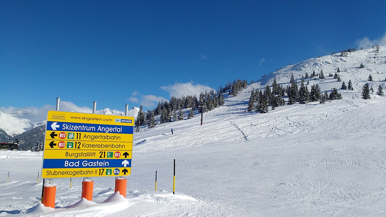
There are two local areas in Bad Gastein - Stubnerkogel and Graukkogel which offers cruising runs that favour intermediate skiers the most. Situated on opposite sides of the resort, these areas aren’t linked together. Because of this it is seen as a fragmented ski resort and area so visitors do have to rely on bus services to get around. The Stubnerkogel area is however linked to Bad Hofgastein’s Schlossalm and Dorfgastein is also linked to the pistes in Grossarl in the nearby valley. Other areas include Sportgastein which lies beyond Bad Gastein at the head of the valley.
Bad Gastein valley has an impressive altitude for Austria, up to 2,686m and also has 800 snow making machines that cover 85% of its slopes.
Bad gastein - middle 1659 m
ECMWF · Εκτέλεση μοντέλου: Αναμενόμενη επόμενη ενημέρωση:
Ημέρα Ώρα (UTC) Θερμ. (°C) Υγρασία (%) Άνεμος (km/h) Άνεμος (κόμβοι) Άνεμος (Bft) Διεύθυνση Υετός (mm) Νέο χιόνι (cm) Πίεση (hPa) Σημείο παγοποίησης (m) Συνθήκες | Τετάρτη, 04/11 06:00 -1.8 92 2 1 1B SE — — 1026 < 1738 Overcast 99% cloud 09:00 1.4 82 3 2 1B SE 0.11 0 1027 1920 Overcast 99% cloud 12:00 3.4 76 3 2 1B SE 0.13 0 1026 2199 Cloudy 69% cloud 15:00 2.6 80 4 2 1B S 0.03 0 1025 2161 Cloudy 64% cloud 18:00 -0.1 88 4 2 1B S 0.03 0 1027 < 1738 Cloudy 69% cloud 21:00 -1 88 4 2 1B S 0 0 1029 < 1738 Cloudy 80% cloud Πέμπτη, 05/11 00:00 -2.3 88 3 2 1B S 0 0 1029 < 1738 Cloudy 77% cloud 03:00 -3.6 89 3 2 1B S 0 0 1028 < 1738 Cloudy 75% cloud 06:00 -4.7 88 3 1 1B S 0 0 1027 < 1738 Cloudy 64% cloud 09:00 3 68 3 2 1B S 0 0 1027 2802 Clear 11% cloud 12:00 6.5 56 3 2 1B S 0 0 1025 3040 Clear 2% cloud 15:00 3.9 68 2 1 1B S 0 0 1024 3095 Clear 1% cloud 18:00 -1.3 80 2 1 1B S 0 0 1024 3004 Clear 0% cloud 21:00 -2.1 72 2 1 1B S 0 0 1024 3016 Clear 1% cloud Παρασκευή, 06/11 00:00 -2.4 69 1 1 1B S 0 0 1023 3012 Clear 1% cloud 03:00 -2.5 66 1 1 1B S 0 0 1022 2928 Clear 1% cloud 06:00 -2.6 64 1 1 1B S 0 0 1021 2874 Clear 1% cloud 09:00 5.5 52 2 1 1B S 0 0 1021 3106 Clear 1% cloud 12:00 8.1 46 2 1 1B S 0 0 1019 3098 Clear 3% cloud 15:00 4.3 64 2 1 1B SE 0 0 1019 3093 Clear 2% cloud 18:00 -1.1 77 3 2 1B S 0 0 1021 < 1738 Clear 1% cloud 21:00 -2.2 75 3 2 1B S 0 0 1022 < 1738 Clear 0% cloud Σάββατο, 07/11 00:00 -2.7 74 3 1 1B S 0 0 1023 < 1738 Clear 5% cloud 03:00 -2.7 73 2 1 1B S 0 0 1022 < 1738 Partly cloudy 48% cloud 06:00 -3 69 2 1 1B S 0 0 1023 < 1738 Partly cloudy 34% cloud 09:00 2.8 54 3 2 1B SE 0 0 1024 2231 Partly cloudy 29% cloud 12:00 4.5 43 4 2 1B SE 0 0 1022 2364 Overcast 86% cloud 15:00 1.4 59 3 2 1B SE 0.07 0 1023 1970 Partly cloudy 48% cloud 18:00 -2.6 68 3 2 1B S 0 0 1025 < 1738 Partly cloudy 22% cloud 21:00 -2.9 70 3 2 1B S 0 0 1026 < 1738 Cloudy 54% cloud Κυριακή, 08/11 00:00 -2.7 70 3 1 1B S 0 0 1025 < 1738 Cloudy 53% cloud 03:00 -3.4 74 2 1 1B S 0 0 1024 < 1738 Partly cloudy 41% cloud 06:00 -3.5 79 3 2 1B S 0.07 0.1 1024 < 1738 Cloudy 68% cloud 09:00 1.2 70 4 2 1B S 0.58 0 1025 1863 Cloudy 77% cloud 12:00 3.6 63 4 2 1B SW 0 0 1024 2129 Partly cloudy 44% cloud 15:00 1.6 70 1 1 1B S 0.03 0 1023 1912 Partly cloudy 33% cloud 18:00 -2.9 84 2 1 1B S 0 0 1024 < 1738 Clear 5% cloud 21:00 -6 89 3 1 1B S 0 0 1025 < 1738 Cloudy 67% cloud Δευτέρα, 09/11 00:00 -6.1 86 3 1 1B S 0 0 1024 < 1738 Partly cloudy 37% cloud 03:00 -5.3 78 2 1 1B S 0 0 1023 < 1738 Cloudy 76% cloud 06:00 -2.5 70 2 1 1B S 0 0 1022 < 1738 Cloudy 79% cloud 09:00 3 56 3 2 1B S 0 0 1022 2377 Cloudy 80% cloud 12:00 5.7 48 3 2 1B S 0 0 1019 2710 Overcast 82% cloud 15:00 2.4 67 3 2 1B S 0 0 1019 2504 Clear 16% cloud 18:00 -1.6 84 4 2 1B S 0 0 1019 < 1738 Overcast 86% cloud 21:00 -1.4 85 4 2 1B S 0 0 1019 < 1738 Overcast 96% cloud Τρίτη, 10/11 00:00 -1.8 86 4 2 1B S 0 0 1018 < 1738 Overcast 96% cloud 03:00 0.3 85 4 2 1B S 0 0 1016 < 1738 Overcast 96% cloud 06:00 -1.2 89 4 2 1B S 0 0 1015 3031 Overcast 89% cloud |
|---|
Forecast notes
Forecast table times: UTC.
Coordinates: 47.11079412°N, 13.11664581°E · Requested elevation: 1659 m. Model terrain: 1736 m. Terrain and 1000/925/850/700 hPa profiles are used for height estimates.
Outside the available profile, temperature uses an estimated 5.5°C/km height correction; wind retains the nearest available model-level value. Humidity is estimated with adjusted pressure and temperature.
These are altitude estimates, not a simulation of local mountain terrain. Precipitation, cloud and sea-level pressure use horizontal interpolation only.
Precipitation includes rain and snow water equivalent: preceding 3 hours through day 6, then 6 hours (see cell tooltip). Snow (cm) estimates fresh snowfall from precipitation and temperature using the GFS conversion; it is not snow depth on the ground. Freezing (m) uses additional 600/500 hPa temperatures when available and estimates the lowest resolved 0°C crossing above sea level. When all sampled levels are warm, the upper profile limit is shown (see tooltip). < marks an entirely cold sampled profile and its lower height limit. No extrapolation is used.
Source: ECMWF · CC BY 4.0 · Processed by Snow Report.
Bad gastein - top 2217 m
ECMWF · Εκτέλεση μοντέλου: Αναμενόμενη επόμενη ενημέρωση:
Ημέρα Ώρα (UTC) Θερμ. (°C) Υγρασία (%) Άνεμος (km/h) Άνεμος (κόμβοι) Άνεμος (Bft) Διεύθυνση Υετός (mm) Νέο χιόνι (cm) Πίεση (hPa) Σημείο παγοποίησης (m) Συνθήκες | Τετάρτη, 04/11 06:00 -3.8 91 11 6 2B SE — — 1026 < 1728 Overcast 99% cloud 09:00 -1.6 86 12 7 3B SE 0.11 0 1027 1919 Overcast 99% cloud 12:00 -0.1 81 11 6 2B SE 0.12 0 1026 2204 Cloudy 68% cloud 15:00 -0.2 79 9 5 2B SE 0.03 0 1025 2172 Cloudy 63% cloud 18:00 -1.7 78 8 4 2B S 0.03 0 1027 < 1728 Cloudy 68% cloud 21:00 -2 73 8 4 2B S 0 0 1029 < 1728 Cloudy 80% cloud Πέμπτη, 05/11 00:00 -2.7 66 7 4 2B S 0 0 1029 < 1728 Cloudy 76% cloud 03:00 -3.2 63 7 4 2B S 0 0 1028 < 1728 Cloudy 74% cloud 06:00 -3.7 61 5 3 1B S 0 0 1027 < 1728 Cloudy 64% cloud 09:00 1.5 55 5 3 1B S 0 0 1027 2805 Clear 12% cloud 12:00 3.9 48 5 2 1B S 0 0 1025 3041 Clear 3% cloud 15:00 2.3 53 3 1 1B S 0 0 1024 3096 Clear 1% cloud 18:00 -1 56 3 2 1B S 0 0 1024 2992 Clear 0% cloud 21:00 -1.5 51 4 2 1B S 0 0 1024 3012 Clear 1% cloud Παρασκευή, 06/11 00:00 -1.7 48 4 2 1B S 0 0 1023 3006 Clear 1% cloud 03:00 -1.7 46 3 2 1B S 0 0 1022 2919 Clear 1% cloud 06:00 -1.7 43 3 2 1B S 0 0 1021 2865 Clear 1% cloud 09:00 3.5 41 5 3 1B S 0 0 1021 3106 Clear 1% cloud 12:00 5.2 38 6 3 2B S 0 0 1019 3098 Clear 3% cloud 15:00 2.6 50 5 3 1B S 0 0 1019 3093 Clear 1% cloud 18:00 -1.1 56 6 3 2B S 0 0 1021 < 1728 Clear 1% cloud 21:00 -2.1 54 10 6 2B S 0 0 1022 < 1728 Clear 0% cloud Σάββατο, 07/11 00:00 -2.7 55 13 7 3B S 0 0 1023 < 1728 Clear 5% cloud 03:00 -3 56 13 7 3B S 0 0 1022 < 1728 Partly cloudy 50% cloud 06:00 -3.3 55 13 7 3B S 0 0 1023 < 1728 Partly cloudy 36% cloud 09:00 0.1 49 15 8 3B SE 0 0 1024 2232 Partly cloudy 29% cloud 12:00 1 46 19 10 3B SE 0 0 1022 2366 Overcast 86% cloud 15:00 -0.9 55 16 9 3B S 0.07 0 1023 1990 Partly cloudy 49% cloud 18:00 -3.6 59 16 8 3B S 0 0 1025 < 1728 Partly cloudy 22% cloud 21:00 -4.2 75 15 8 3B S 0 0 1025 < 1728 Cloudy 56% cloud Κυριακή, 08/11 00:00 -4.2 75 11 6 2B S 0 0 1025 < 1728 Cloudy 53% cloud 03:00 -4.8 76 8 4 2B SW 0 0 1024 < 1728 Partly cloudy 40% cloud 06:00 -5 79 9 5 2B SW 0.07 0.1 1025 < 1728 Cloudy 70% cloud 09:00 -2.3 76 9 5 2B SW 0.67 0.2 1025 1857 Cloudy 79% cloud 12:00 -0.8 69 8 4 2B SW 0 0 1024 2126 Partly cloudy 46% cloud 15:00 -2.1 74 5 3 1B W 0.02 0 1023 1914 Partly cloudy 33% cloud 18:00 -4.7 79 5 3 1B W 0 0 1024 < 1728 Clear 5% cloud 21:00 -6.2 68 7 4 2B W 0 0 1025 < 1728 Cloudy 68% cloud Δευτέρα, 09/11 00:00 -6 63 8 4 2B W 0 0 1024 < 1728 Partly cloudy 33% cloud 03:00 -5.1 57 8 4 2B W 0 0 1023 < 1728 Cloudy 77% cloud 06:00 -3.2 64 7 4 2B SW 0 0 1022 < 1728 Cloudy 79% cloud 09:00 0.7 57 9 5 2B SW 0 0 1022 2379 Cloudy 79% cloud 12:00 2.7 52 9 5 2B W 0 0 1019 2712 Overcast 83% cloud 15:00 0.8 63 8 4 2B SW 0 0 1019 2517 Clear 15% cloud 18:00 -1.7 76 10 6 2B W 0 0 1019 < 1728 Overcast 85% cloud 21:00 -1.5 77 9 5 2B SW 0 0 1019 < 1728 Overcast 96% cloud Τρίτη, 10/11 00:00 -1.4 80 11 6 2B W 0 0 1018 < 1728 Overcast 96% cloud 03:00 -0.1 83 11 6 2B W 0 0 1016 < 1728 Overcast 96% cloud 06:00 -1 86 12 7 2B W 0 0 1015 3036 Overcast 88% cloud |
|---|
Forecast notes
Forecast table times: UTC.
Coordinates: 47.11219606°N, 13.099823°E · Requested elevation: 2217 m. Model terrain: 1726 m. Terrain and 1000/925/850/700 hPa profiles are used for height estimates.
These are altitude estimates, not a simulation of local mountain terrain. Precipitation, cloud and sea-level pressure use horizontal interpolation only.
Precipitation includes rain and snow water equivalent: preceding 3 hours through day 6, then 6 hours (see cell tooltip). Snow (cm) estimates fresh snowfall from precipitation and temperature using the GFS conversion; it is not snow depth on the ground. Freezing (m) uses additional 600/500 hPa temperatures when available and estimates the lowest resolved 0°C crossing above sea level. When all sampled levels are warm, the upper profile limit is shown (see tooltip). < marks an entirely cold sampled profile and its lower height limit. No extrapolation is used.