Previsioni per le stazioni sciistiche di tutto il mondo

Altro
Legenda dei colori Temperatura · Vento · Pioggia · Neve
Ogni colore inizia dal valore indicato. I colori del vento corrispondono nelle tre unità di misura. Le celle senza precipitazioni restano neutre. I colori descrivono i valori visualizzati, non avvisi meteo ufficiali.
Arapahoe Basin - Low lift station
ECMWF · Elaborazione del modello: Prossimo aggiornamento previsto:
Giorno Ora (UTC) Temp. (°C) Umidità (%) Vento (km/h) Vento (nodi) Vento (Bft) Direzione Precip. (mm) Neve (cm) Pressione (hPa) Zero termico (m) Condizioni | Mercoledì, 04/11 06:00 -5.9 87 3 2 1B SW — — 1019 — Clear 1% cloud  09:00 -5.9 84 4 2 1B W 0 0 1017 — Clear 7% cloud 12:00 -5.9 75 1 0 0B SW 0 0 1015 — Partly cloudy 43% cloud  15:00 -0.5 50 3 2 1B SE 0 0 1013 — Cloudy 63% cloud  18:00 4.2 32 9 5 2B SE 0 0 1010 — Clear 9% cloud 21:00 2 45 10 5 2B SE 0.48 0 1010 — Overcast 83% cloud  Giovedì, 05/11 00:00 -2.5 80 6 3 2B E 1.4 0.4 1013 — Overcast 99% cloud 03:00 -4 83 6 3 2B E 1.5 1.5 1016 — Overcast 98% cloud 06:00 -5.4 84 2 1 1B NE 0.25 0.3 1020 — Overcast 96% cloud 09:00 -7.8 89 1 1 1B NE 0.03 0 1020 — Cloudy 74% cloud 12:00 -7.9 74 1 0 0B NE 0 0 1020 — Clear 2% cloud 15:00 -3.7 59 0 0 0B S 0 0 1022 — Clear 1% cloud 18:00 2.5 39 6 3 1B SE 0 0 1019 — Clear 0% cloud 21:00 3.2 37 6 3 2B SE 0 0 1017 — Clear 12% cloud Venerdì, 06/11 00:00 -3.5 65 5 3 1B SE 0 0 1020 — Clear 1% cloud 03:00 -5.5 70 3 2 1B S 0 0 1022 — Cloudy 67% cloud 06:00 -5.3 70 3 2 1B S 0 0 1023 — Overcast 87% cloud 09:00 -4.8 64 2 1 1B S 0 0 1022 — Overcast 97% cloud 12:00 -5.1 60 1 1 1B SW 0 0 1022 — Overcast 82% cloud 15:00 -2.1 50 2 1 1B W 0 0 1024 — Cloudy 71% cloud 18:00 3.4 37 4 2 1B NW 0 0 1022 — Cloudy 75% cloud 21:00 3.5 40 5 3 1B NW 0.03 0 1020 — Overcast 99% cloud Sabato, 07/11 00:00 -1.4 64 2 1 1B N 0.03 0 1023 — Cloudy 60% cloud 03:00 -3.4 74 1 1 1B W 0.03 0 1025 — Clear 10% cloud 06:00 -5 79 2 1 1B W 0 0 1025 — Clear 0% cloud 09:00 -6 84 3 1 1B W 0 0 1026 — Clear 0% cloud 12:00 -7.5 86 3 2 1B W 0 0 1027 — Clear 3% cloud 15:00 -3.9 75 3 2 1B W 0 0 1028 — Clear 6% cloud 18:00 3.9 31 4 2 1B NW 0 0 1024 — Clear 0% cloud 21:00 5.6 26 3 2 1B NW 0 0 1022 — Clear 0% cloud Domenica, 08/11 00:00 -1.4 50 1 1 0B NW 0 0 1024 — Clear 7% cloud 03:00 -3.3 53 2 1 1B W 0 0 1026 — Partly cloudy 43% cloud 06:00 -4.1 47 1 0 0B W 0 0 1026 — Cloudy 55% cloud 09:00 -4.4 32 1 1 0B S 0 0 1026 — Clear 1% cloud 12:00 -4.5 26 2 1 1B SW 0 0 1024 — Clear 0% cloud 15:00 -0.3 24 2 1 1B W 0 0 1025 — Clear 1% cloud 18:00 7.3 18 6 3 2B NW 0 0 1023 — Clear 0% cloud 21:00 7.8 20 9 5 2B NW 0 0 1021 — Clear 0% cloud Lunedì, 09/11 00:00 -0.9 42 3 2 1B W 0 0 1023 — Clear 0% cloud 03:00 -2.6 49 4 2 1B W 0 0 1024 — Clear 0% cloud 06:00 -3.2 48 3 2 1B W 0 0 1024 — Clear 0% cloud 09:00 -3.8 48 3 2 1B W 0 0 1024 — Clear 0% cloud 12:00 -4.5 49 3 1 1B W 0 0 1023 — Clear 0% cloud 15:00 -0.3 37 2 1 1B NW 0 0 1024 — Clear 0% cloud 18:00 7.7 19 4 2 1B NW 0 0 1021 — Clear 0% cloud 21:00 8.3 20 8 5 2B NW 0 0 1019 — Clear 0% cloud Martedì, 10/11 00:00 -0.5 47 3 2 1B NW 0 0 1022 — Clear 0% cloud 03:00 -2.3 54 2 1 1B NW 0 0 1024 — Clear 0% cloud 06:00 -2.9 57 0 0 0B SE 0 0 1023 — Clear 0% cloud |
|---|
Forecast notes
Forecast table times: UTC.
Coordinates: 39.6411672°N, -105.8748596°E · Requested elevation: 3289 m. Model terrain: 3346 m. Terrain and 1000/925/850/700 hPa profiles are used for height estimates.
Outside the available profile, temperature uses an estimated 5.5°C/km height correction; wind retains the nearest available model-level value. Humidity is estimated with adjusted pressure and temperature.
These are altitude estimates, not a simulation of local mountain terrain. Precipitation, cloud and sea-level pressure use horizontal interpolation only.
Precipitation includes rain and snow water equivalent: preceding 3 hours through day 6, then 6 hours (see cell tooltip). Snow (cm) estimates fresh snowfall from precipitation and temperature using the GFS conversion; it is not snow depth on the ground. Freezing (m) uses additional 600/500 hPa temperatures when available and estimates the lowest resolved 0°C crossing above sea level. When all sampled levels are warm, the upper profile limit is shown (see tooltip). < marks an entirely cold sampled profile and its lower height limit. No extrapolation is used.
Source: ECMWF · CC BY 4.0 · Processed by Snow Report.
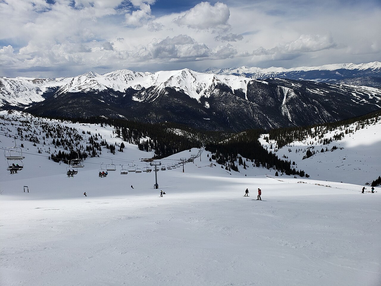
Arapahoe Basin is a downhill ski area in Colorado, United States. Mapped terrain includes easy, intermediate, advanced, expert routes. Its mapped lift network extends from approximately 3289 to 3803 metres above sea level.
Data: OpenSkiData / OpenSkiMap, OpenStreetMap contributors (ODbL), Skimap.org, Who's On First, Mapterhorn.
Arapahoe Basin - Base lift station
ECMWF · Elaborazione del modello: Prossimo aggiornamento previsto:
Giorno Ora (UTC) Temp. (°C) Umidità (%) Vento (km/h) Vento (nodi) Vento (Bft) Direzione Precip. (mm) Neve (cm) Pressione (hPa) Zero termico (m) Condizioni | Mercoledì, 04/11 06:00 -5.9 87 3 2 1B SW — — 1019 — Clear 1% cloud 09:00 -5.9 84 4 2 1B W 0 0 1017 — Clear 7% cloud 12:00 -5.9 75 1 0 0B SW 0 0 1015 — Partly cloudy 43% cloud 15:00 -0.5 50 3 2 1B SE 0 0 1013 — Cloudy 63% cloud 18:00 4.2 32 9 5 2B SE 0 0 1010 — Clear 9% cloud 21:00 2 45 10 5 2B SE 0.48 0 1010 — Overcast 83% cloud Giovedì, 05/11 00:00 -2.5 80 6 3 2B E 1.4 0.4 1013 — Overcast 99% cloud 03:00 -4 83 6 3 2B E 1.5 1.5 1016 — Overcast 98% cloud 06:00 -5.4 84 2 1 1B NE 0.25 0.3 1020 — Overcast 96% cloud 09:00 -7.8 89 1 1 1B NE 0.03 0 1020 — Cloudy 74% cloud 12:00 -7.9 74 1 0 0B NE 0 0 1020 — Clear 2% cloud 15:00 -3.7 59 0 0 0B S 0 0 1022 — Clear 1% cloud 18:00 2.5 39 6 3 1B SE 0 0 1019 — Clear 0% cloud 21:00 3.2 37 6 3 2B SE 0 0 1017 — Clear 12% cloud Venerdì, 06/11 00:00 -3.5 65 5 3 1B SE 0 0 1020 — Clear 1% cloud 03:00 -5.5 70 3 2 1B S 0 0 1022 — Cloudy 67% cloud 06:00 -5.3 70 3 2 1B S 0 0 1023 — Overcast 87% cloud 09:00 -4.8 64 2 1 1B S 0 0 1022 — Overcast 97% cloud 12:00 -5.1 60 1 1 1B SW 0 0 1022 — Overcast 82% cloud 15:00 -2.1 50 2 1 1B W 0 0 1024 — Cloudy 71% cloud 18:00 3.4 37 4 2 1B NW 0 0 1022 — Cloudy 75% cloud 21:00 3.5 40 5 3 1B NW 0.03 0 1020 — Overcast 99% cloud Sabato, 07/11 00:00 -1.4 64 2 1 1B N 0.03 0 1023 — Cloudy 60% cloud 03:00 -3.4 74 1 1 1B W 0.03 0 1025 — Clear 10% cloud 06:00 -5 79 2 1 1B W 0 0 1025 — Clear 0% cloud 09:00 -6 84 3 1 1B W 0 0 1026 — Clear 0% cloud 12:00 -7.5 86 3 2 1B W 0 0 1027 — Clear 3% cloud 15:00 -3.9 75 3 2 1B W 0 0 1028 — Clear 6% cloud 18:00 3.9 31 4 2 1B NW 0 0 1024 — Clear 0% cloud 21:00 5.6 26 3 2 1B NW 0 0 1022 — Clear 0% cloud Domenica, 08/11 00:00 -1.4 50 1 1 0B NW 0 0 1024 — Clear 7% cloud 03:00 -3.3 53 2 1 1B W 0 0 1026 — Partly cloudy 43% cloud 06:00 -4.1 47 1 0 0B W 0 0 1026 — Cloudy 55% cloud 09:00 -4.4 32 1 1 0B S 0 0 1026 — Clear 1% cloud 12:00 -4.5 26 2 1 1B SW 0 0 1024 — Clear 0% cloud 15:00 -0.3 24 2 1 1B W 0 0 1025 — Clear 1% cloud 18:00 7.3 18 6 3 2B NW 0 0 1023 — Clear 0% cloud 21:00 7.8 20 9 5 2B NW 0 0 1021 — Clear 0% cloud Lunedì, 09/11 00:00 -0.9 42 3 2 1B W 0 0 1023 — Clear 0% cloud 03:00 -2.6 49 4 2 1B W 0 0 1024 — Clear 0% cloud 06:00 -3.2 48 3 2 1B W 0 0 1024 — Clear 0% cloud 09:00 -3.8 48 3 2 1B W 0 0 1024 — Clear 0% cloud 12:00 -4.5 49 3 1 1B W 0 0 1023 — Clear 0% cloud 15:00 -0.3 37 2 1 1B NW 0 0 1024 — Clear 0% cloud 18:00 7.7 19 4 2 1B NW 0 0 1021 — Clear 0% cloud 21:00 8.3 20 8 5 2B NW 0 0 1019 — Clear 0% cloud Martedì, 10/11 00:00 -0.5 47 3 2 1B NW 0 0 1022 — Clear 0% cloud 03:00 -2.3 54 2 1 1B NW 0 0 1024 — Clear 0% cloud 06:00 -2.9 57 0 0 0B SE 0 0 1023 — Clear 0% cloud |
|---|
Forecast notes
Forecast table times: UTC.
Coordinates: 39.6411672°N, -105.8748596°E · Requested elevation: 3289 m. Model terrain: 3346 m. Terrain and 1000/925/850/700 hPa profiles are used for height estimates.
Outside the available profile, temperature uses an estimated 5.5°C/km height correction; wind retains the nearest available model-level value. Humidity is estimated with adjusted pressure and temperature.
These are altitude estimates, not a simulation of local mountain terrain. Precipitation, cloud and sea-level pressure use horizontal interpolation only.
Precipitation includes rain and snow water equivalent: preceding 3 hours through day 6, then 6 hours (see cell tooltip). Snow (cm) estimates fresh snowfall from precipitation and temperature using the GFS conversion; it is not snow depth on the ground. Freezing (m) uses additional 600/500 hPa temperatures when available and estimates the lowest resolved 0°C crossing above sea level. When all sampled levels are warm, the upper profile limit is shown (see tooltip). < marks an entirely cold sampled profile and its lower height limit. No extrapolation is used.
Source: ECMWF · CC BY 4.0 · Processed by Snow Report.
Arapahoe Basin - Top lift station
ECMWF · Elaborazione del modello: Prossimo aggiornamento previsto:
Giorno Ora (UTC) Temp. (°C) Umidità (%) Vento (km/h) Vento (nodi) Vento (Bft) Direzione Precip. (mm) Neve (cm) Pressione (hPa) Zero termico (m) Condizioni | Mercoledì, 04/11 06:00 -8.6 100 3 2 1B W — — 1019 — Clear 1% cloud 09:00 -8.7 98 4 2 1B W 0 0 1017 — Clear 7% cloud 12:00 -8.6 86 0 0 0B W 0 0 1015 — Partly cloudy 41% cloud 15:00 -3.3 56 3 2 1B SE 0 0 1013 — Cloudy 64% cloud 18:00 1.3 37 9 5 2B SE 0 0 1010 — Clear 9% cloud 21:00 -0.7 51 10 5 2B SE 0.49 0.1 1010 — Overcast 82% cloud Giovedì, 05/11 00:00 -5.3 94 6 3 2B E 1.4 1.4 1013 — Overcast 99% cloud 03:00 -6.8 97 6 3 2B NE 1.5 1.5 1016 — Overcast 98% cloud 06:00 -8.2 97 2 1 1B NE 0.24 0.2 1019 — Overcast 96% cloud 09:00 -10.6 100 1 1 1B N 0.03 0 1020 — Cloudy 72% cloud 12:00 -10.7 87 1 1 0B N 0 0 1020 — Clear 2% cloud 15:00 -6.5 68 0 0 0B — 0 0 1022 — Clear 1% cloud 18:00 -0.3 44 6 3 1B SE 0 0 1019 — Clear 0% cloud 21:00 0.3 43 6 4 2B SE 0 0 1018 — Clear 10% cloud Venerdì, 06/11 00:00 -6.3 76 5 3 1B SE 0 0 1020 — Clear 1% cloud 03:00 -8.2 81 3 2 1B S 0 0 1022 — Cloudy 65% cloud 06:00 -8.1 81 3 2 1B S 0 0 1023 — Overcast 87% cloud 09:00 -7.6 74 2 1 1B S 0 0 1022 — Overcast 97% cloud 12:00 -7.9 70 1 1 1B W 0 0 1022 — Overcast 81% cloud 15:00 -4.9 58 2 1 1B NW 0 0 1024 — Cloudy 69% cloud 18:00 0.6 42 4 2 1B NW 0 0 1022 — Cloudy 78% cloud 21:00 0.7 45 5 2 1B NW 0.03 0 1020 — Overcast 99% cloud Sabato, 07/11 00:00 -4.1 73 2 1 1B N 0.03 0 1023 — Cloudy 63% cloud 03:00 -6.2 85 1 1 1B W 0.03 0 1025 — Clear 11% cloud 06:00 -7.8 92 2 1 1B W 0 0 1025 — Clear 0% cloud 09:00 -8.8 97 3 1 1B W 0 0 1026 — Clear 0% cloud 12:00 -10.3 100 3 2 1B W 0 0 1027 — Clear 2% cloud 15:00 -6.6 87 3 2 1B W 0 0 1028 — Clear 5% cloud 18:00 1.1 35 4 2 1B NW 0 0 1024 — Clear 0% cloud 21:00 2.9 29 3 2 1B NW 0 0 1022 — Clear 0% cloud Domenica, 08/11 00:00 -4.1 57 1 1 0B W 0 0 1024 — Clear 7% cloud 03:00 -6.1 61 2 1 1B NW 0 0 1026 — Partly cloudy 42% cloud 06:00 -6.8 56 1 0 0B W 0 0 1026 — Cloudy 53% cloud 09:00 -7 38 1 0 0B S 0 0 1026 — Clear 1% cloud 12:00 -7.3 31 2 1 1B SW 0 0 1024 — Clear 0% cloud 15:00 -3.1 27 2 1 1B W 0 0 1025 — Clear 1% cloud 18:00 4.5 20 6 3 2B NW 0 0 1023 — Clear 0% cloud 21:00 5.1 22 9 5 2B NW 0 0 1021 — Clear 0% cloud Lunedì, 09/11 00:00 -3.7 47 3 2 1B W 0 0 1023 — Clear 0% cloud 03:00 -5.5 57 4 2 1B W 0 0 1024 — Clear 0% cloud 06:00 -6 55 3 2 1B W 0 0 1024 — Clear 0% cloud 09:00 -6.6 56 3 2 1B NW 0 0 1024 — Clear 0% cloud 12:00 -7.3 57 3 1 1B NW 0 0 1023 — Clear 0% cloud 15:00 -3.1 42 2 1 1B NW 0 0 1024 — Clear 0% cloud 18:00 4.9 21 4 2 1B NW 0 0 1021 — Clear 0% cloud 21:00 5.6 22 9 5 2B NW 0 0 1019 — Clear 0% cloud Martedì, 10/11 00:00 -3.3 53 3 2 1B NW 0 0 1022 — Clear 0% cloud 03:00 -5.1 62 2 1 1B NW 0 0 1024 — Clear 0% cloud 06:00 -5.6 66 0 0 0B SE 0 0 1023 — Clear 0% cloud |
|---|
Forecast notes
Forecast table times: UTC.
Coordinates: 39.6234629°N, -105.8741496°E · Requested elevation: 3803 m. Model terrain: 3349 m. Terrain and 1000/925/850/700 hPa profiles are used for height estimates.
Outside the available profile, temperature uses an estimated 5.5°C/km height correction; wind retains the nearest available model-level value. Humidity is estimated with adjusted pressure and temperature.
These are altitude estimates, not a simulation of local mountain terrain. Precipitation, cloud and sea-level pressure use horizontal interpolation only.
Precipitation includes rain and snow water equivalent: preceding 3 hours through day 6, then 6 hours (see cell tooltip). Snow (cm) estimates fresh snowfall from precipitation and temperature using the GFS conversion; it is not snow depth on the ground. Freezing (m) uses additional 600/500 hPa temperatures when available and estimates the lowest resolved 0°C crossing above sea level. When all sampled levels are warm, the upper profile limit is shown (see tooltip). < marks an entirely cold sampled profile and its lower height limit. No extrapolation is used.