Arabba · Porta Vescovo · Panorama

Provider panorama/video player. Capture time is shown by the camera.
Open camera page ↗
Chaque couleur commence à la valeur indiquée. Les couleurs du vent correspondent dans les trois unités. Les cases sans précipitations restent neutres. Les couleurs décrivent les valeurs affichées et ne sont pas des alertes officielles.
ECMWF · Cycle du modèle : Prochaine mise à jour attendue :
Jour Heure (UTC) Temp. (°C) Humidité (%) Vent (km/h) Vent (nœuds) Vent (Bft) Direction Précip. (mm) Neige fraîche (cm) Pression (hPa) Isotherme 0 °C (m) Conditions | Mercredi, 04/11 06:00 1.2 83 2 1 1B E — — 1025 < 1996 Cloudy 80% cloud  09:00 3.2 68 5 3 1B SE 0.00 0 1025 2131 Overcast 100% cloud  12:00 3.5 69 4 2 1B SE 0.03 0 1026 2172 Overcast 100% cloud 15:00 3 71 3 2 1B SE 0.03 0 1026 2142 Cloudy 75% cloud 18:00 0.6 82 1 0 0B SE 0.00 0 1027 < 1996 Cloudy 69% cloud 21:00 -0 82 1 0 0B NE 0 0 1029 < 1996 Partly cloudy 20% cloud  Jeudi, 05/11 00:00 -0.5 81 1 0 0B N 0 0 1028 < 1996 Clear 15% cloud  03:00 -0.5 77 1 1 1B N 0 0 1027 < 1996 Clear 10% cloud 06:00 0.1 73 0 0 0B NE 0 0 1027 < 1996 Clear 1% cloud 09:00 5.3 56 2 1 1B S 0 0 1027 2664 Clear 0% cloud 12:00 7.4 50 3 2 1B S 0 0 1025 2800 Clear 0% cloud 15:00 5 68 0 0 0B S 0 0 1025 2832 Clear 0% cloud 18:00 1.3 72 1 1 1B NW 0 0 1026 < 1996 Clear 0% cloud 21:00 1.3 71 1 0 0B N 0 0 1025 < 1996 Clear 0% cloud Vendredi, 06/11 00:00 1.9 65 0 0 0B NW 0 0 1024 < 1996 Clear 0% cloud 03:00 2.3 60 0 0 0B NE 0 0 1022 2288 Clear 0% cloud 06:00 2.5 59 0 0 0B S 0 0 1022 2405 Clear 0% cloud 09:00 7.6 47 3 2 1B S 0 0 1021 2970 Clear 5% cloud 12:00 9 48 4 2 1B S 0 0 1020 2960 Clear 3% cloud 15:00 5.5 68 2 1 1B SE 0 0 1020 2767 Clear 19% cloud 18:00 1.4 80 1 1 1B NE 0 0 1021 < 1996 Cloudy 66% cloud 21:00 2.6 80 2 1 1B E 0 0 1022 2148 Overcast 100% cloud Samedi, 07/11 00:00 2.4 78 1 1 1B E 0.12 0 1022 2062 Overcast 98% cloud 03:00 1.5 70 1 1 0B E 0.06 0 1021 < 1996 Partly cloudy 47% cloud 06:00 1.3 65 1 1 0B SE 0.00 0 1023 < 1996 Overcast 85% cloud 09:00 2.6 61 4 2 1B E 0.57 0 1024 2076 Overcast 100% cloud 12:00 3.3 60 4 2 1B SE 0.79 0 1023 2160 Overcast 100% cloud 15:00 2.1 64 3 1 1B SE 0.12 0 1024 < 1996 Overcast 100% cloud 18:00 0.8 78 2 1 1B SE 0.37 0.1 1025 < 1996 Overcast 100% cloud 21:00 0.6 79 1 1 1B E 0.30 0.1 1026 < 1996 Overcast 93% cloud Dimanche, 08/11 00:00 -0 79 1 1 0B E 0 0 1026 < 1996 Overcast 97% cloud 03:00 -0.6 79 1 0 0B E 0.13 0 1025 < 1996 Overcast 98% cloud 06:00 0 76 1 0 0B SW 0.30 0.1 1025 < 1996 Overcast 88% cloud 09:00 1.7 73 4 2 1B SW 0 0 1026 < 1996 Overcast 98% cloud 12:00 3.1 64 5 2 1B SW 0.06 0 1024 2114 Overcast 86% cloud 15:00 2.4 68 3 1 1B SW 0.06 0 1024 2038 Overcast 82% cloud 18:00 -0.9 82 1 0 0B E 0 0 1026 < 1996 Cloudy 61% cloud 21:00 -2.8 83 1 0 0B N 0 0 1026 < 1996 Partly cloudy 50% cloud Lundi, 09/11 00:00 -3.9 82 2 1 1B NW 0 0 1025 < 1996 Clear 18% cloud 03:00 -1.8 68 1 0 0B NW 0 0 1024 < 1996 Cloudy 71% cloud 06:00 -0.8 64 0 0 0B NW 0 0 1024 < 1996 Cloudy 59% cloud 09:00 3.7 57 3 2 1B SW 0 0 1024 2461 Partly cloudy 45% cloud 12:00 5.2 58 5 3 1B SW 0 0 1021 2646 Partly cloudy 35% cloud 15:00 3.3 73 4 2 1B SW 0 0 1021 2365 Overcast 88% cloud 18:00 0.6 84 2 1 1B SW 0 0 1022 < 1996 Overcast 93% cloud 21:00 2.4 85 3 1 1B SW 0.00 0 1022 2090 Overcast 100% cloud Mardi, 10/11 00:00 2.6 87 2 1 1B SW 0.06 0 1020 2205 Overcast 100% cloud 03:00 3 87 2 1 1B SW 0.00 0 1018 2416 Overcast 100% cloud 06:00 3.1 87 1 1 1B SW 0.00 0 1017 2483 Overcast 100% cloud |
|---|
Forecast table times: UTC.
Coordinates: 46.4956308°N, 11.8740293°E · Requested elevation: 1607 m. Model terrain: 1994 m. Terrain and 1000/925/850/700 hPa profiles are used for height estimates.
Outside the available profile, temperature uses an estimated 5.5°C/km height correction; wind retains the nearest available model-level value. Humidity is estimated with adjusted pressure and temperature.
These are altitude estimates, not a simulation of local mountain terrain. Precipitation, cloud and sea-level pressure use horizontal interpolation only.
Precipitation includes rain and snow water equivalent: preceding 3 hours through day 6, then 6 hours (see cell tooltip). Snow (cm) estimates fresh snowfall from precipitation and temperature using the GFS conversion; it is not snow depth on the ground. Freezing (m) uses additional 600/500 hPa temperatures when available and estimates the lowest resolved 0°C crossing above sea level. When all sampled levels are warm, the upper profile limit is shown (see tooltip). < marks an entirely cold sampled profile and its lower height limit. No extrapolation is used.
Source: ECMWF · CC BY 4.0 · Processed by Snow Report.
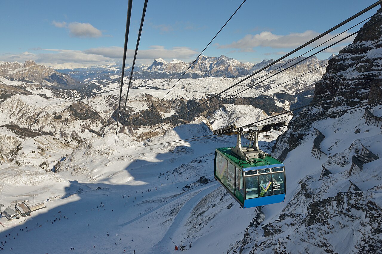
Arabba se trouve sur le réseau de la Sellaronda, avec Porta Vescovo comme secteur d’altitude entre le paysage du Sella et la Marmolada. Le plan Arabba–Marmolada montre aussi les liaisons Pordoi, Padon et Campolongo. On peut donc y choisir des pistes locales, une partie du tour du Sella ou une excursion plus longue vers la Marmolada.
Ces programmes ne sont pas équivalents. Repérez le trajet sur le plan et examinez difficultés, liaisons et retour. Le nom d’une région sur le forfait ne prouve pas que toutes les remontées de liaison fonctionnent. Le plan officiel lié ici est l’édition 2025–26 ; consultez les informations actuelles de l’exploitant pour les changements avant le voyage.
Le point bas de référence de cette page est à 1 607 m. Pour Porta Vescovo ou une sortie plus haute, choisissez l’altitude correspondante et comparez les horaires de vent, nuages et précipitations. Si les modèles annoncent tous deux de la neige mais pas à la même heure, ce décalage peut compter davantage pour un grand circuit qu’une petite différence de cumul. Des webcams basses et hautes peuvent montrer des précipitations de nature différente au même moment.
Sources officielles: Arabba — Porta Vescovo · Arabba–Marmolada piste map. Informations vérifiées le 18 octobre 2026.
Provider panorama/video player. Capture time is shown by the camera.
Open camera page ↗ECMWF · Cycle du modèle : Prochaine mise à jour attendue :
Jour Heure (UTC) Temp. (°C) Humidité (%) Vent (km/h) Vent (nœuds) Vent (Bft) Direction Précip. (mm) Neige fraîche (cm) Pression (hPa) Isotherme 0 °C (m) Conditions | Mercredi, 04/11 06:00 1.2 83 2 1 1B E — — 1025 < 1996 Cloudy 80% cloud 09:00 3.1 68 5 3 1B SE 0.00 0 1025 2131 Overcast 100% cloud 12:00 3.5 69 4 2 1B SE 0.03 0 1026 2172 Overcast 100% cloud 15:00 3 71 3 2 1B SE 0.03 0 1026 2142 Cloudy 75% cloud 18:00 0.6 82 1 0 0B SE 0.00 0 1027 < 1996 Cloudy 69% cloud 21:00 -0 82 1 0 0B NE 0 0 1029 < 1996 Partly cloudy 21% cloud Jeudi, 05/11 00:00 -0.5 81 1 0 0B N 0 0 1028 < 1996 Clear 15% cloud 03:00 -0.5 77 1 1 1B N 0 0 1027 < 1996 Clear 10% cloud 06:00 0.1 73 0 0 0B N 0 0 1027 < 1996 Clear 1% cloud 09:00 5.3 56 2 1 1B S 0 0 1027 2664 Clear 0% cloud 12:00 7.4 50 4 2 1B S 0 0 1025 2800 Clear 0% cloud 15:00 5 68 0 0 0B S 0 0 1025 2832 Clear 0% cloud 18:00 1.3 72 1 1 1B NW 0 0 1026 < 1996 Clear 0% cloud 21:00 1.3 71 1 0 0B N 0 0 1025 < 1996 Clear 0% cloud Vendredi, 06/11 00:00 1.9 65 0 0 0B NW 0 0 1024 < 1996 Clear 0% cloud 03:00 2.2 60 0 0 0B NE 0 0 1022 2288 Clear 0% cloud 06:00 2.5 59 0 0 0B S 0 0 1022 2405 Clear 0% cloud 09:00 7.6 47 3 2 1B S 0 0 1021 2970 Clear 5% cloud 12:00 9 48 4 2 1B S 0 0 1020 2960 Clear 3% cloud 15:00 5.5 68 2 1 1B SE 0 0 1020 2767 Clear 19% cloud 18:00 1.4 80 1 1 1B NE 0 0 1021 < 1996 Cloudy 66% cloud 21:00 2.6 80 2 1 1B E 0 0 1022 2148 Overcast 100% cloud Samedi, 07/11 00:00 2.4 78 1 1 1B E 0.12 0 1022 2062 Overcast 98% cloud 03:00 1.4 70 1 1 0B E 0.06 0 1021 < 1996 Partly cloudy 47% cloud 06:00 1.3 65 1 1 0B SE 0.00 0 1023 < 1996 Overcast 85% cloud 09:00 2.6 62 4 2 1B E 0.57 0 1024 2076 Overcast 100% cloud 12:00 3.3 60 4 2 1B SE 0.79 0 1023 2160 Overcast 100% cloud 15:00 2.1 64 3 1 1B SE 0.12 0 1024 < 1996 Overcast 100% cloud 18:00 0.8 78 2 1 1B SE 0.37 0.1 1025 < 1996 Overcast 100% cloud 21:00 0.6 79 1 1 1B E 0.30 0.1 1026 < 1996 Overcast 93% cloud Dimanche, 08/11 00:00 -0 79 1 1 0B E 0 0 1026 < 1996 Overcast 97% cloud 03:00 -0.6 79 1 0 0B E 0.12 0 1025 < 1996 Overcast 98% cloud 06:00 0 76 1 0 0B SW 0.30 0.1 1025 < 1996 Overcast 88% cloud 09:00 1.7 73 4 2 1B SW 0 0 1026 < 1996 Overcast 98% cloud 12:00 3.1 64 5 2 1B SW 0.06 0 1024 2114 Overcast 86% cloud 15:00 2.4 68 3 1 1B SW 0.06 0 1024 2038 Overcast 82% cloud 18:00 -0.9 82 1 0 0B E 0 0 1026 < 1996 Cloudy 61% cloud 21:00 -2.8 84 1 0 0B N 0 0 1026 < 1996 Partly cloudy 50% cloud Lundi, 09/11 00:00 -3.9 82 2 1 1B NW 0 0 1025 < 1996 Clear 18% cloud 03:00 -1.8 68 1 0 0B NW 0 0 1024 < 1996 Cloudy 71% cloud 06:00 -0.8 64 0 0 0B NW 0 0 1024 < 1996 Cloudy 59% cloud 09:00 3.7 57 3 2 1B SW 0 0 1024 2461 Partly cloudy 45% cloud 12:00 5.2 58 5 3 1B SW 0 0 1021 2646 Partly cloudy 35% cloud 15:00 3.3 73 4 2 1B SW 0 0 1021 2365 Overcast 88% cloud 18:00 0.5 84 2 1 1B SW 0 0 1022 < 1996 Overcast 93% cloud 21:00 2.3 85 3 1 1B SW 0.00 0 1022 2090 Overcast 100% cloud Mardi, 10/11 00:00 2.6 87 2 1 1B SW 0.06 0 1020 2205 Overcast 100% cloud 03:00 2.9 88 2 1 1B SW 0.00 0 1018 2417 Overcast 100% cloud 06:00 3.1 87 1 1 1B SW 0.00 0 1017 2484 Overcast 100% cloud |
|---|
Forecast table times: UTC.
Coordinates: 46.495421°N, 11.8744431°E · Requested elevation: 1610 m. Model terrain: 1993 m. Terrain and 1000/925/850/700 hPa profiles are used for height estimates.
Outside the available profile, temperature uses an estimated 5.5°C/km height correction; wind retains the nearest available model-level value. Humidity is estimated with adjusted pressure and temperature.
These are altitude estimates, not a simulation of local mountain terrain. Precipitation, cloud and sea-level pressure use horizontal interpolation only.
Precipitation includes rain and snow water equivalent: preceding 3 hours through day 6, then 6 hours (see cell tooltip). Snow (cm) estimates fresh snowfall from precipitation and temperature using the GFS conversion; it is not snow depth on the ground. Freezing (m) uses additional 600/500 hPa temperatures when available and estimates the lowest resolved 0°C crossing above sea level. When all sampled levels are warm, the upper profile limit is shown (see tooltip). < marks an entirely cold sampled profile and its lower height limit. No extrapolation is used.
Source: ECMWF · CC BY 4.0 · Processed by Snow Report.
ECMWF · Cycle du modèle : Prochaine mise à jour attendue :
Jour Heure (UTC) Temp. (°C) Humidité (%) Vent (km/h) Vent (nœuds) Vent (Bft) Direction Précip. (mm) Neige fraîche (cm) Pression (hPa) Isotherme 0 °C (m) Conditions | Mercredi, 04/11 06:00 -3.7 91 8 5 2B SE — — 1025 < 1965 Overcast 80% cloud 09:00 -2.8 84 11 6 2B SE 0.00 0 1025 2123 Overcast 100% cloud 12:00 -2.5 85 10 5 2B SE 0.04 0 1026 2167 Overcast 99% cloud 15:00 -2.1 78 9 5 2B S 0.03 0 1026 2147 Cloudy 76% cloud 18:00 -2.9 78 8 4 2B S 0.00 0 1027 < 1965 Cloudy 70% cloud 21:00 -3.2 76 7 4 2B S 0 0 1029 < 1965 Partly cloudy 25% cloud Jeudi, 05/11 00:00 -3 68 7 4 2B SW 0 0 1028 < 1965 Clear 17% cloud 03:00 -2.7 61 7 4 2B S 0 0 1027 < 1965 Clear 15% cloud 06:00 -2 56 8 4 2B S 0 0 1027 < 1965 Clear 3% cloud 09:00 0.8 52 8 4 2B SW 0 0 1027 2662 Clear 0% cloud 12:00 2 52 8 4 2B SW 0 0 1025 2796 Clear 1% cloud 15:00 1.2 58 5 3 1B SW 0 0 1025 2832 Clear 0% cloud 18:00 -0.7 56 3 2 1B S 0 0 1026 < 1965 Clear 0% cloud 21:00 -0.7 55 4 2 1B S 0 0 1025 < 1965 Clear 0% cloud Vendredi, 06/11 00:00 -0.4 53 5 3 1B S 0 0 1024 < 1965 Clear 0% cloud 03:00 -0.2 54 6 3 1B S 0 0 1022 < 1965 Clear 0% cloud 06:00 -0.2 54 5 3 1B S 0 0 1022 2284 Clear 0% cloud 09:00 2.7 49 8 4 2B S 0 0 1021 2966 Clear 5% cloud 12:00 3.3 49 9 5 2B S 0 0 1020 2956 Clear 3% cloud 15:00 1.2 62 8 4 2B S 0 0 1020 2765 Clear 19% cloud 18:00 -1.2 66 8 4 2B SE 0 0 1021 < 1965 Cloudy 70% cloud 21:00 -1.2 66 14 7 3B SE 0 0 1022 2133 Overcast 100% cloud Samedi, 07/11 00:00 -1.7 72 19 10 3B SE 0.11 0 1022 2050 Overcast 98% cloud 03:00 -2.5 64 17 9 3B SE 0.06 0 1021 < 1965 Partly cloudy 49% cloud 06:00 -3.3 72 16 9 3B SE 0.01 0 1023 < 1965 Overcast 87% cloud 09:00 -2.7 74 19 10 3B SE 0.68 0.2 1024 2063 Overcast 100% cloud 12:00 -2.4 79 13 7 3B SE 0.78 0.2 1023 2147 Overcast 100% cloud 15:00 -2.9 83 7 4 2B SE 0.12 0.1 1024 1985 Overcast 100% cloud 18:00 -3.6 92 6 3 2B S 0.38 0.4 1025 < 1965 Overcast 100% cloud 21:00 -4 89 6 3 2B S 0.28 0.3 1026 < 1965 Overcast 92% cloud Dimanche, 08/11 00:00 -4.5 89 7 4 2B S 0 0 1026 < 1965 Overcast 96% cloud 03:00 -5 92 8 5 2B SW 0.14 0.1 1025 < 1965 Overcast 98% cloud 06:00 -4.8 88 8 4 2B SW 0.28 0.3 1025 < 1965 Overcast 89% cloud 09:00 -4 85 10 5 2B SW 0 0 1026 < 1965 Overcast 99% cloud 12:00 -3.2 78 9 5 2B SW 0.06 0.1 1025 2109 Overcast 86% cloud 15:00 -3.2 76 9 5 2B W 0.07 0.1 1024 2030 Overcast 83% cloud 18:00 -4.2 66 9 5 2B W 0 0 1026 < 1965 Cloudy 59% cloud 21:00 -4.9 63 9 5 2B W 0 0 1026 < 1965 Cloudy 50% cloud Lundi, 09/11 00:00 -5.1 61 11 6 2B W 0 0 1025 < 1965 Partly cloudy 22% cloud 03:00 -3.6 58 9 5 2B W 0 0 1024 < 1965 Cloudy 72% cloud 06:00 -2.8 61 11 6 2B W 0 0 1024 < 1965 Cloudy 61% cloud 09:00 -0.1 59 13 7 3B W 0 0 1024 2465 Partly cloudy 48% cloud 12:00 0.8 62 15 8 3B SW 0 0 1022 2649 Partly cloudy 40% cloud 15:00 -0.4 73 19 10 3B W 0 0 1022 2370 Overcast 89% cloud 18:00 -1.9 88 18 10 3B W 0 0 1022 < 1965 Overcast 94% cloud 21:00 -1 92 23 12 4B W 0.01 0 1022 2107 Overcast 100% cloud Mardi, 10/11 00:00 -0.6 94 25 13 4B W 0.07 0 1020 2223 Overcast 100% cloud 03:00 -0.1 92 23 13 4B W 0.01 0 1018 2428 Overcast 100% cloud 06:00 0 93 23 12 4B W 0.01 0 1017 2493 Overcast 100% cloud |
|---|
Forecast table times: UTC.
Coordinates: 46.4731123°N, 11.8671064°E · Requested elevation: 2485 m. Model terrain: 1962 m. Terrain and 1000/925/850/700 hPa profiles are used for height estimates.
These are altitude estimates, not a simulation of local mountain terrain. Precipitation, cloud and sea-level pressure use horizontal interpolation only.
Precipitation includes rain and snow water equivalent: preceding 3 hours through day 6, then 6 hours (see cell tooltip). Snow (cm) estimates fresh snowfall from precipitation and temperature using the GFS conversion; it is not snow depth on the ground. Freezing (m) uses additional 600/500 hPa temperatures when available and estimates the lowest resolved 0°C crossing above sea level. When all sampled levels are warm, the upper profile limit is shown (see tooltip). < marks an entirely cold sampled profile and its lower height limit. No extrapolation is used.