Seceda · Val Gardena · Panorama

Provider panorama/video player. Capture time is shown by the camera.
Open camera page ↗
Cada color comienza en el valor indicado. Los colores del viento coinciden en las tres unidades. Las celdas sin precipitación permanecen neutras. Los colores describen los valores mostrados, no son avisos meteorológicos oficiales.
Preparando gráficos de previsión…
Las horas y los valores coinciden con la previsión detallada. Toca un valor para ver detalles y desplaza los gráficos horizontalmente para los próximos días. La precipitación es el equivalente total en agua por intervalo, incluida la nieve; la nieve nueva corresponde a cada intervalo, no al espesor de nieve en el suelo.
Comparación de GFS y ECMWF. Cada modelo conserva sus propias horas y horizonte de previsión. Las cantidades de precipitación y nieve corresponden a sus propios intervalos, que pueden diferir entre modelos.
ECMWF · Ejecución del modelo: Próxima actualización prevista:
Día Hora local Temp. (°C) Humedad (%) Viento (km/h) Viento (nudos) Viento (Bft) Dirección Precip. (mm) Nieve nueva (cm) Presión (hPa) Isoterma de 0 °C (m) Condiciones | Miércoles, 04/11 07:00 2.7 80 2 1 1B E — — 1024 1734 Cloudy 69% cloud  10:00 5.7 64 2 1 1B SE 0.01 0 1025 2115 Overcast 82% cloud  13:00 6.9 58 2 1 1B SE 0.04 0 1025 2223 Overcast 87% cloud 16:00 5.9 64 2 1 1B SE 0.02 0 1025 2205 Overcast 80% cloud 19:00 2.9 75 1 0 0B SE 0 0 1026 1808 Overcast 81% cloud 22:00 1.5 76 1 1 1B SE 0.03 0 1028 < 1691 Partly cloudy 39% cloud  Jueves, 05/11 01:00 1.2 76 0 0 0B E 0 0 1028 < 1691 Partly cloudy 38% cloud 04:00 0.9 75 1 0 0B E 0 0 1028 < 1691 Partly cloudy 24% cloud 07:00 0.6 74 0 0 0B E 0 0 1028 < 1691 Clear 4% cloud  10:00 6.5 54 1 1 0B SW 0 0 1028 2622 Clear 1% cloud 13:00 9.1 49 3 2 1B SW 0 0 1026 2775 Clear 0% cloud 16:00 7.2 63 1 1 0B W 0 0 1025 2886 Clear 0% cloud 19:00 2.9 70 0 0 0B E 0 0 1026 2305 Clear 0% cloud 22:00 2.4 70 0 0 0B E 0 0 1026 < 1691 Clear 0% cloud Viernes, 06/11 01:00 2.3 67 0 0 0B E 0 0 1025 < 1691 Clear 0% cloud 04:00 2.4 64 1 0 0B E 0 0 1024 < 1691 Clear 0% cloud 07:00 2.5 63 0 0 0B S 0 0 1023 < 1691 Clear 0% cloud 10:00 8.3 47 1 1 1B SW 0 0 1022 2930 Clear 7% cloud 13:00 10.9 44 2 1 1B SW 0 0 1020 2940 Clear 6% cloud 16:00 8.2 60 1 1 0B SW 0 0 1019 2789 Partly cloudy 27% cloud 19:00 3.6 72 1 1 1B SE 0 0 1020 2173 Overcast 82% cloud 22:00 3.8 74 1 1 1B SE 0 0 1021 2093 Overcast 99% cloud Sábado, 07/11 01:00 3.8 74 1 1 1B E 0.09 0 1022 2004 Overcast 97% cloud 04:00 2.9 72 1 0 0B E 0.09 0 1021 1800 Cloudy 75% cloud 07:00 2.7 69 1 1 0B S 0.07 0 1023 1731 Overcast 91% cloud 10:00 4.5 68 2 1 1B E 0.77 0 1024 2029 Overcast 99% cloud 13:00 5.8 64 2 1 1B E 0.47 0 1023 2153 Overcast 95% cloud 16:00 4.9 65 1 1 1B SE 0.20 0 1023 2063 Overcast 96% cloud 19:00 3.5 74 2 1 1B SE 0.17 0 1024 1869 Overcast 99% cloud 22:00 3 75 1 1 1B E 0.26 0 1025 1787 Overcast 97% cloud Domingo, 08/11 01:00 2.6 75 1 0 0B E 0.14 0 1025 1706 Overcast 98% cloud 04:00 1.9 77 1 1 0B SE 0.24 0 1025 < 1691 Overcast 98% cloud 07:00 2.3 77 1 1 0B S 0.24 0 1025 < 1691 Overcast 100% cloud 10:00 3.9 74 3 1 1B SW 0.06 0 1026 1886 Overcast 92% cloud 13:00 5.6 63 4 2 1B SW 0.13 0 1025 2076 Cloudy 71% cloud 16:00 4.8 68 3 1 1B SW 0.02 0 1024 2025 Cloudy 61% cloud 19:00 0.8 80 1 1 1B SE 0 0 1026 < 1691 Cloudy 59% cloud 22:00 -1 81 1 1 1B SE 0 0 1026 < 1691 Cloudy 62% cloud Lunes, 09/11 01:00 -2.1 81 1 1 1B E 0 0 1026 < 1691 Partly cloudy 41% cloud 04:00 -0.5 75 1 0 0B E 0 0 1025 < 1691 Cloudy 77% cloud 07:00 0.3 72 1 0 0B SE 0 0 1025 < 1691 Cloudy 76% cloud 10:00 4.8 60 3 1 1B SW 0 0 1025 2420 Cloudy 62% cloud 13:00 6.9 57 4 2 1B SW 0 0 1022 2609 Partly cloudy 42% cloud 16:00 5.1 70 4 2 1B SW 0 0 1022 2414 Overcast 87% cloud 19:00 2.3 80 2 1 1B S 0 0 1022 < 1691 Overcast 93% cloud 22:00 4 80 2 1 1B S 0 0 1022 2213 Overcast 100% cloud Martes, 10/11 01:00 3.9 83 1 1 1B S 0.08 0 1021 2265 Overcast 99% cloud 04:00 4 84 2 1 1B S 0.04 0 1019 2435 Overcast 100% cloud 07:00 4.3 84 1 1 0B SE 0 0 1018 2517 Overcast 100% cloud |
|---|
Forecast table times: Europe/Rome.
Coordinates: 46.57219672°N, 11.6709137°E · Requested elevation: 1235 m. Model terrain: 1689 m. Terrain and 1000/925/850/700 hPa profiles are used for height estimates.
Outside the available profile, temperature uses an estimated 5.5°C/km height correction; wind retains the nearest available model-level value. Humidity is estimated with adjusted pressure and temperature.
These are altitude estimates, not a simulation of local mountain terrain. Precipitation, cloud and sea-level pressure use horizontal interpolation only.
Precipitation includes rain and snow water equivalent: preceding 3 hours through day 6, then 6 hours (see cell tooltip). Snow (cm) estimates fresh snowfall from precipitation and temperature using the GFS conversion; it is not snow depth on the ground. Freezing (m) uses additional 600/500 hPa temperatures when available and estimates the lowest resolved 0°C crossing above sea level. When all sampled levels are warm, the upper profile limit is shown (see tooltip). < marks an entirely cold sampled profile and its lower height limit. No extrapolation is used.
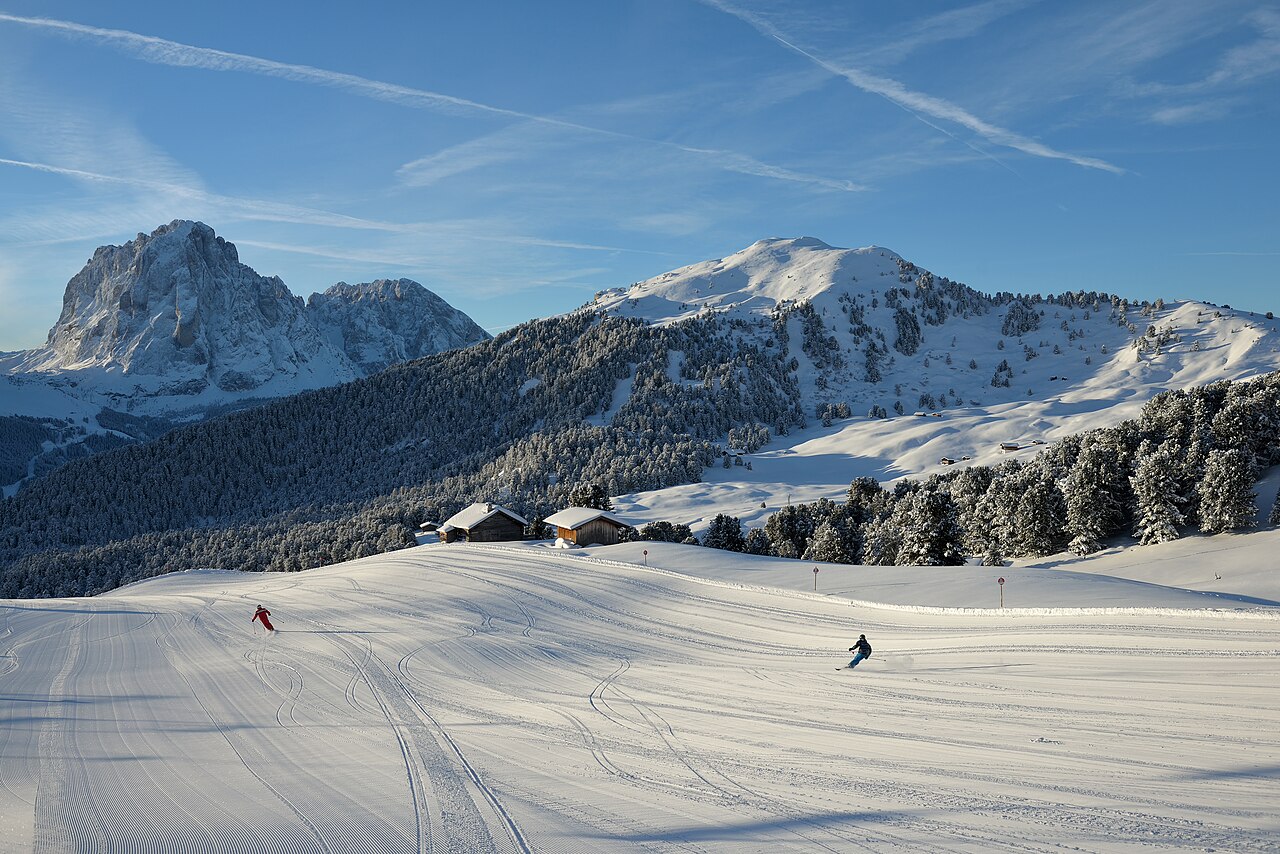
Val Gardena offers several different starting points for a Dolomites ski day. Ortisei gives access to Seceda and Alpe di Siusi, while Santa Cristina and Selva lead into other parts of the valley’s network. From Seceda, La Longia is a long red descent back to Ortisei; it should not be confused with the Sellaronda circuit around the Sella massif.
The official itinerary descriptions are particularly useful here because not every tour is simply a chain of ski lifts and pistes. The Val Gardena Ronda includes a ski-bus transfer between Saltria and Monte Pana. Before choosing a full-day circuit, check its transport sections and return options as well as its distance. The live report lists the two Sellaronda directions separately.
Our selected point is at 1,235 m, close to the elevation of Ortisei rather than the upper ski terrain. Use a higher point for a day around Seceda, and keep the lower forecast for the return. The temperature change between morning and afternoon can matter over a long descent. Snowfall predicted at one height should not be applied unchanged to every part of the valley.
Official sources: Val Gardena ski itineraries · Seceda — winter · Val Gardena open slopes. Reviewed 18 October 2026.
Provider panorama/video player. Capture time is shown by the camera.
Open camera page ↗Preparando gráficos de previsión…
Las horas y los valores coinciden con la previsión detallada. Toca un valor para ver detalles y desplaza los gráficos horizontalmente para los próximos días. La precipitación es el equivalente total en agua por intervalo, incluida la nieve; la nieve nueva corresponde a cada intervalo, no al espesor de nieve en el suelo.
Comparación de GFS y ECMWF. Cada modelo conserva sus propias horas y horizonte de previsión. Las cantidades de precipitación y nieve corresponden a sus propios intervalos, que pueden diferir entre modelos.
ECMWF · Ejecución del modelo: Próxima actualización prevista:
Día Hora local Temp. (°C) Humedad (%) Viento (km/h) Viento (nudos) Viento (Bft) Dirección Precip. (mm) Nieve nueva (cm) Presión (hPa) Isoterma de 0 °C (m) Condiciones | Miércoles, 04/11 07:00 -0.7 91 3 2 1B SE — — 1024 1742 Cloudy 67% cloud 10:00 1.9 74 4 2 1B SE 0.00 0 1025 2122 Overcast 83% cloud 13:00 2.9 68 4 2 1B SE 0.04 0 1025 2224 Overcast 89% cloud 16:00 2.2 74 4 2 1B S 0.02 0 1025 2203 Cloudy 79% cloud 19:00 -0.3 83 3 2 1B S 0 0 1027 1795 Overcast 81% cloud 22:00 -1.5 83 3 1 1B S 0.03 0 1028 < 1696 Partly cloudy 41% cloud Jueves, 05/11 01:00 -1.6 81 2 1 1B S 0 0 1028 < 1696 Partly cloudy 40% cloud 04:00 -1.8 78 2 1 1B S 0 0 1028 < 1696 Partly cloudy 25% cloud 07:00 -2 77 2 1 1B S 0 0 1028 < 1696 Clear 4% cloud 10:00 3.2 59 3 2 1B SW 0 0 1028 2624 Clear 1% cloud 13:00 5.5 55 5 2 1B SW 0 0 1026 2772 Clear 0% cloud 16:00 3.9 67 2 1 1B SW 0 0 1025 2880 Clear 0% cloud 19:00 0.3 73 1 1 1B S 0 0 1026 2289 Clear 0% cloud 22:00 -0.2 72 1 1 1B S 0 0 1026 < 1696 Clear 0% cloud Viernes, 06/11 01:00 -0.2 71 2 1 1B S 0 0 1025 < 1696 Clear 0% cloud 04:00 -0.1 67 2 1 1B S 0 0 1023 < 1696 Clear 0% cloud 07:00 -0 67 2 1 1B S 0 0 1023 1818 Clear 0% cloud 10:00 5 52 3 2 1B S 0 0 1022 2929 Clear 8% cloud 13:00 7.2 49 4 2 1B SW 0 0 1020 2939 Clear 7% cloud 16:00 4.6 66 3 1 1B S 0 0 1019 2785 Partly cloudy 27% cloud 19:00 0.7 78 3 2 1B SE 0 0 1020 2182 Overcast 84% cloud 22:00 0.8 79 5 3 1B SE 0 0 1021 2104 Overcast 99% cloud Sábado, 07/11 01:00 0.5 81 6 3 1B SE 0.09 0 1021 2009 Overcast 97% cloud 04:00 -0.3 78 5 3 1B SE 0.09 0 1021 1807 Cloudy 76% cloud 07:00 -0.6 77 5 3 1B SE 0.07 0 1023 1743 Overcast 92% cloud 10:00 0.9 78 6 3 2B SE 0.82 0.2 1024 2023 Overcast 99% cloud 13:00 2 74 4 2 1B SE 0.48 0 1023 2155 Overcast 95% cloud 16:00 1.2 77 3 1 1B S 0.22 0 1023 2057 Overcast 97% cloud 19:00 -0.1 86 3 2 1B SE 0.17 0 1024 1862 Overcast 99% cloud 22:00 -0.5 87 2 1 1B S 0.28 0.1 1025 1783 Overcast 97% cloud Domingo, 08/11 01:00 -0.9 87 2 1 1B S 0.16 0 1025 1708 Overcast 98% cloud 04:00 -1.5 89 3 1 1B S 0.26 0.1 1025 < 1696 Overcast 99% cloud 07:00 -1.3 89 3 2 1B SW 0.25 0 1025 < 1696 Overcast 100% cloud 10:00 0.1 85 5 2 1B SW 0.06 0 1026 1886 Overcast 92% cloud 13:00 1.6 73 5 3 1B SW 0.13 0 1025 2074 Cloudy 69% cloud 16:00 1 77 4 2 1B W 0.02 0 1024 2020 Cloudy 61% cloud 19:00 -2.2 85 1 1 1B W 0 0 1026 < 1696 Cloudy 61% cloud 22:00 -3.7 84 1 1 1B W 0 0 1026 < 1696 Cloudy 63% cloud Lunes, 09/11 01:00 -4.5 84 1 1 1B W 0 0 1026 < 1696 Partly cloudy 41% cloud 04:00 -3.1 79 2 1 1B SW 0 0 1025 < 1696 Cloudy 76% cloud 07:00 -2.3 78 2 1 1B W 0 0 1025 < 1696 Cloudy 77% cloud 10:00 1.8 67 5 3 1B SW 0 0 1025 2424 Cloudy 62% cloud 13:00 3.5 64 7 4 2B SW 0 0 1022 2605 Partly cloudy 42% cloud 16:00 1.9 77 7 4 2B SW 0 0 1022 2412 Overcast 88% cloud 19:00 -0.5 89 5 3 1B SW 0 0 1022 < 1696 Overcast 94% cloud 22:00 1 90 7 4 2B SW 0 0 1022 2218 Overcast 100% cloud Martes, 10/11 01:00 1 93 6 3 2B SW 0.08 0 1021 2272 Overcast 99% cloud 04:00 1.2 94 6 3 1B SW 0.03 0 1019 2442 Overcast 100% cloud 07:00 1.4 94 5 3 1B SW 0 0 1018 2524 Overcast 100% cloud |
|---|
Forecast table times: Europe/Rome.
Coordinates: 46.55956851°N, 11.66524887°E · Requested elevation: 1874 m. Model terrain: 1693 m. Terrain and 1000/925/850/700 hPa profiles are used for height estimates.
These are altitude estimates, not a simulation of local mountain terrain. Precipitation, cloud and sea-level pressure use horizontal interpolation only.
Precipitation includes rain and snow water equivalent: preceding 3 hours through day 6, then 6 hours (see cell tooltip). Snow (cm) estimates fresh snowfall from precipitation and temperature using the GFS conversion; it is not snow depth on the ground. Freezing (m) uses additional 600/500 hPa temperatures when available and estimates the lowest resolved 0°C crossing above sea level. When all sampled levels are warm, the upper profile limit is shown (see tooltip). < marks an entirely cold sampled profile and its lower height limit. No extrapolation is used.
Preparando gráficos de previsión…
Las horas y los valores coinciden con la previsión detallada. Toca un valor para ver detalles y desplaza los gráficos horizontalmente para los próximos días. La precipitación es el equivalente total en agua por intervalo, incluida la nieve; la nieve nueva corresponde a cada intervalo, no al espesor de nieve en el suelo.
Comparación de GFS y ECMWF. Cada modelo conserva sus propias horas y horizonte de previsión. Las cantidades de precipitación y nieve corresponden a sus propios intervalos, que pueden diferir entre modelos.
ECMWF · Ejecución del modelo: Próxima actualización prevista:
Día Hora local Temp. (°C) Humedad (%) Viento (km/h) Viento (nudos) Viento (Bft) Dirección Precip. (mm) Nieve nueva (cm) Presión (hPa) Isoterma de 0 °C (m) Condiciones | Miércoles, 04/11 07:00 -4.2 87 9 5 2B SE — — 1024 1730 Partly cloudy 50% cloud 10:00 -3 82 11 6 2B SE 0.00 0 1025 2127 Cloudy 75% cloud 13:00 -2.4 80 11 6 2B SE 0.02 0 1024 2225 Overcast 95% cloud 16:00 -2.1 79 10 6 2B S 0.04 0 1025 2198 Cloudy 71% cloud 19:00 -2.8 76 10 5 2B S 0 0 1026 1843 Cloudy 78% cloud 22:00 -2.9 65 11 6 2B S 0.08 0.1 1028 < 1493 Cloudy 62% cloud Jueves, 05/11 01:00 -2.5 61 10 5 2B S 0 0 1028 < 1493 Cloudy 63% cloud 04:00 -2.3 54 12 6 2B S 0 0 1028 < 1493 Partly cloudy 37% cloud 07:00 -1.9 53 12 6 2B S 0 0 1028 < 1493 Clear 6% cloud 10:00 0.4 52 13 7 3B SW 0 0 1028 2609 Clear 1% cloud 13:00 1.3 52 12 7 3B SW 0 0 1026 2750 Clear 0% cloud 16:00 1.4 50 8 4 2B SW 0 0 1026 2873 Clear 0% cloud 19:00 0.1 51 6 3 1B S 0 0 1026 2572 Clear 0% cloud 22:00 -0.2 52 8 4 2B S 0 0 1026 2248 Clear 0% cloud Viernes, 06/11 01:00 -0.1 53 9 5 2B S 0 0 1025 2301 Clear 0% cloud 04:00 -0.1 51 9 5 2B S 0 0 1024 2415 Clear 0% cloud 07:00 -0.3 53 9 5 2B S 0 0 1024 2222 Clear 0% cloud 10:00 1.7 49 11 6 2B S 0 0 1023 2910 Clear 8% cloud 13:00 2.5 48 12 6 2B S 0 0 1020 2919 Clear 10% cloud 16:00 1.2 57 10 5 2B S 0 0 1020 2764 Partly cloudy 27% cloud 19:00 -0.5 63 11 6 2B SE 0 0 1020 2359 Overcast 93% cloud 22:00 -1.3 60 18 10 3B SE 0 0 1021 2160 Overcast 99% cloud Sábado, 07/11 01:00 -2.1 70 25 14 4B SE 0.04 0 1021 2020 Overcast 93% cloud 04:00 -2.7 66 23 12 4B SE 0.12 0 1021 1853 Overcast 87% cloud 07:00 -3.7 80 21 11 4B SE 0.17 0.2 1023 1779 Overcast 98% cloud 10:00 -3.2 89 21 12 4B SE 1.2 1.2 1024 1965 Overcast 100% cloud 13:00 -2.6 89 11 6 2B SE 0.44 0.1 1023 2140 Overcast 98% cloud 16:00 -3.1 93 8 4 2B S 0.44 0.4 1023 2025 Overcast 99% cloud 19:00 -3.6 95 8 4 2B S 0.15 0.2 1024 1867 Overcast 100% cloud 22:00 -3.9 93 8 4 2B S 0.40 0.4 1025 1805 Overcast 98% cloud Domingo, 08/11 01:00 -4.3 94 8 4 2B S 0.41 0.4 1025 1747 Overcast 99% cloud 04:00 -4.8 94 11 6 2B SW 0.40 0.4 1025 1625 Overcast 100% cloud 07:00 -5.1 94 11 6 2B SW 0.20 0.2 1025 1627 Overcast 100% cloud 10:00 -4.6 92 11 6 2B SW 0.09 0.1 1026 1850 Overcast 84% cloud 13:00 -3.6 78 11 6 2B W 0.13 0.1 1025 2056 Cloudy 54% cloud 16:00 -3.4 70 12 6 2B W 0.00 0 1025 2011 Cloudy 57% cloud 19:00 -3.9 57 10 6 2B W 0 0 1026 < 1493 Cloudy 62% cloud 22:00 -4.1 55 11 6 2B W 0 0 1026 < 1493 Cloudy 76% cloud Lunes, 09/11 01:00 -4 50 12 6 2B W 0 0 1026 < 1493 Cloudy 55% cloud 04:00 -3 58 12 7 2B SW 0 0 1025 < 1493 Cloudy 77% cloud 07:00 -2.3 62 13 7 3B W 0 0 1025 < 1493 Overcast 85% cloud 10:00 -0.2 61 16 9 3B W 0 0 1025 2456 Cloudy 66% cloud 13:00 0.3 62 18 10 3B SW 0 0 1023 2587 Partly cloudy 47% cloud 16:00 -0.2 69 22 12 4B W 0 0 1022 2477 Overcast 91% cloud 19:00 -1.3 85 22 12 4B SW 0 0 1022 1986 Overcast 95% cloud 22:00 -0.7 89 27 14 4B SW 0 0 1022 2304 Overcast 100% cloud Martes, 10/11 01:00 -0.4 91 29 16 5B SW 0.04 0 1021 2376 Overcast 98% cloud 04:00 0 88 26 14 4B W 0.01 0 1019 2524 Overcast 99% cloud 07:00 0.2 91 26 14 4B SW 0 0 1018 2600 Overcast 99% cloud |
|---|
Forecast table times: Europe/Rome.
Coordinates: 46.51091656°N, 11.57546997°E · Requested elevation: 2518 m. Model terrain: 1490 m. Terrain and 1000/925/850/700 hPa profiles are used for height estimates.
These are altitude estimates, not a simulation of local mountain terrain. Precipitation, cloud and sea-level pressure use horizontal interpolation only.
Precipitation includes rain and snow water equivalent: preceding 3 hours through day 6, then 6 hours (see cell tooltip). Snow (cm) estimates fresh snowfall from precipitation and temperature using the GFS conversion; it is not snow depth on the ground. Freezing (m) uses additional 600/500 hPa temperatures when available and estimates the lowest resolved 0°C crossing above sea level. When all sampled levels are warm, the upper profile limit is shown (see tooltip). < marks an entirely cold sampled profile and its lower height limit. No extrapolation is used.