全球滑雪场天气预报

颜色说明 温度 · 风 · 降雨 · 降雪
每种颜色从所示数值开始。三种风速单位的颜色相互对应。无降水单元格保持中性色。颜色仅描述显示值,并非官方天气预警。
正在准备预报图表…
时间和数值与详细预报一致。点击数值查看详情,横向滚动查看后续日期。降水量为每时段总水当量,包含降雪;新雪量指每时段新增降雪,并非地面积雪深度。
GFS与ECMWF模式对比。各模式保留各自的预报时间和时长。降水量和降雪量对应各模式自身的时段,模式之间的时段可能不同。
预报数值与模式说明
Stevens Pass - Low lift station
ECMWF · 模式起报时间: 预计下次更新:
日期 时间(UTC) 气温(°C) 湿度(%) 风速(km/h) 风速(节) 风力(Bft) 风向 降水(mm) 新雪(cm) 气压(hPa) 零度层(m) 天气状况 | 星期三, 04/11 06:00 0.6 81 1 0 0B SE — — 1020 < 1325 Clear 1% cloud  09:00 1.9 73 1 0 0B S 0 0 1019 2370 Clear 0% cloud 12:00 1 75 1 1 1B SE 0 0 1019 1481 Clear 0% cloud 15:00 -0 77 2 1 1B E 0 0 1019 < 1325 Clear 4% cloud 18:00 7.8 57 3 2 1B E 0 0 1017 2768 Cloudy 79% cloud  21:00 9.8 53 1 1 1B NE 0 0 1015 2690 Overcast 96% cloud  星期四, 05/11 00:00 5.2 77 1 0 0B N 0 0 1016 2318 Overcast 100% cloud 03:00 3.9 81 2 1 1B SW 0 0 1017 1975 Overcast 100% cloud 06:00 2.8 91 3 2 1B SW 1.3 0 1019 1759 Overcast 100% cloud 09:00 2.6 93 6 3 1B SW 2.0 0 1020 1678 Overcast 100% cloud 12:00 2.5 95 8 4 2B SW 0.51 0 1021 1628 Overcast 100% cloud 15:00 2 94 6 3 1B W 1.2 0 1023 1544 Overcast 100% cloud 18:00 2.7 94 8 5 2B SW 0.45 0 1025 1654 Overcast 96% cloud 21:00 5.1 68 9 5 2B W 0.07 0 1024 2144 Cloudy 79% cloud 星期五, 06/11 00:00 3.8 77 4 2 1B W 0 0 1024 1954 Partly cloudy 26% cloud  03:00 -0.2 88 3 1 1B S 0 0 1024 < 1325 Overcast 97% cloud 06:00 -0.8 81 2 1 1B SE 0 0 1024 < 1325 Cloudy 61% cloud 09:00 -1.3 80 3 2 1B SE 0 0 1023 < 1325 Cloudy 65% cloud 12:00 1.9 71 3 2 1B SE 0 0 1021 1877 Overcast 100% cloud 15:00 1.8 85 2 1 1B SE 0.71 0 1023 1905 Overcast 100% cloud 18:00 3 89 4 2 1B E 2.0 0 1022 2494 Overcast 100% cloud 21:00 6.5 84 1 1 1B S 0.57 0 1020 2918 Overcast 100% cloud 星期六, 07/11 00:00 5.2 88 2 1 1B SE 3.2 0 1018 3057 Overcast 100% cloud 03:00 4.8 91 4 2 1B SW 6.9 0 1021 2390 Overcast 100% cloud 06:00 5.1 93 5 2 1B SW 1.5 0 1021 2390 Overcast 100% cloud 09:00 5 93 4 2 1B SW 0.29 0 1021 2756 Cloudy 78% cloud 12:00 3.4 91 3 1 1B SE 0.00 0 1019 2483 Partly cloudy 29% cloud 15:00 2.4 80 6 3 1B E 0 0 1019 2821 Overcast 88% cloud 18:00 6.9 85 9 5 2B E 0 0 1020 3086 Overcast 99% cloud 21:00 9.1 76 10 5 2B E 0 0 1017 3075 Overcast 98% cloud 星期日, 08/11 00:00 6.8 87 9 5 2B E 0 0 1015 3061 Overcast 97% cloud 03:00 3.6 92 7 4 2B E 0 0 1013 2510 Overcast 96% cloud 06:00 4.4 76 8 4 2B SE 0 0 1010 2703 Overcast 83% cloud 09:00 5.7 86 11 6 2B SW 1.9 0 1010 2383 Overcast 100% cloud 12:00 4.3 94 16 9 3B SW 8.7 0 1014 1893 Overcast 99% cloud 15:00 2.9 95 18 10 3B SW 2.1 0 1017 1661 Overcast 94% cloud 18:00 3.3 92 18 10 3B SW 2.1 0 1021 1710 Overcast 96% cloud 21:00 3.6 89 14 8 3B W 1.5 0 1022 1734 Overcast 95% cloud 星期一, 09/11 00:00 2.7 93 8 5 2B W 0.77 0 1024 1619 Overcast 100% cloud 03:00 1.7 93 6 3 1B SW 0.12 0 1025 1495 Overcast 100% cloud 06:00 0.6 92 2 1 1B S 0 0 1025 < 1325 Overcast 100% cloud 09:00 -2 91 2 1 1B E 0 0 1024 < 1325 Clear 11% cloud 12:00 -1.8 85 5 3 1B SE 0 0 1022 < 1325 Clear 12% cloud 15:00 -1.6 83 4 2 1B E 0 0 1023 < 1325 Overcast 98% cloud 18:00 3.9 68 5 3 1B E 0 0 1022 2154 Overcast 99% cloud 21:00 6.6 56 5 3 1B E 0 0 1020 2278 Overcast 92% cloud 星期二, 10/11 00:00 3.9 73 4 2 1B E 0 0 1020 1957 Overcast 82% cloud 03:00 1.2 83 4 2 1B E 0 0 1020 1489 Cloudy 60% cloud 06:00 1.4 81 3 2 1B E 0 0 1019 1589 Cloudy 79% cloud |
|---|
Forecast notes
Forecast table times: UTC.
Coordinates: 47.7307427°N, -121.0689986°E · Requested elevation: 1166 m. Model terrain: 1322 m. Terrain and 1000/925/850/700 hPa profiles are used for height estimates.
Outside the available profile, temperature uses an estimated 5.5°C/km height correction; wind retains the nearest available model-level value. Humidity is estimated with adjusted pressure and temperature.
These are altitude estimates, not a simulation of local mountain terrain. Precipitation, cloud and sea-level pressure use horizontal interpolation only.
Precipitation includes rain and snow water equivalent: preceding 3 hours through day 6, then 6 hours (see cell tooltip). Snow (cm) estimates fresh snowfall from precipitation and temperature using the GFS conversion; it is not snow depth on the ground. Freezing (m) uses additional 600/500 hPa temperatures when available and estimates the lowest resolved 0°C crossing above sea level. When all sampled levels are warm, the upper profile limit is shown (see tooltip). < marks an entirely cold sampled profile and its lower height limit. No extrapolation is used.
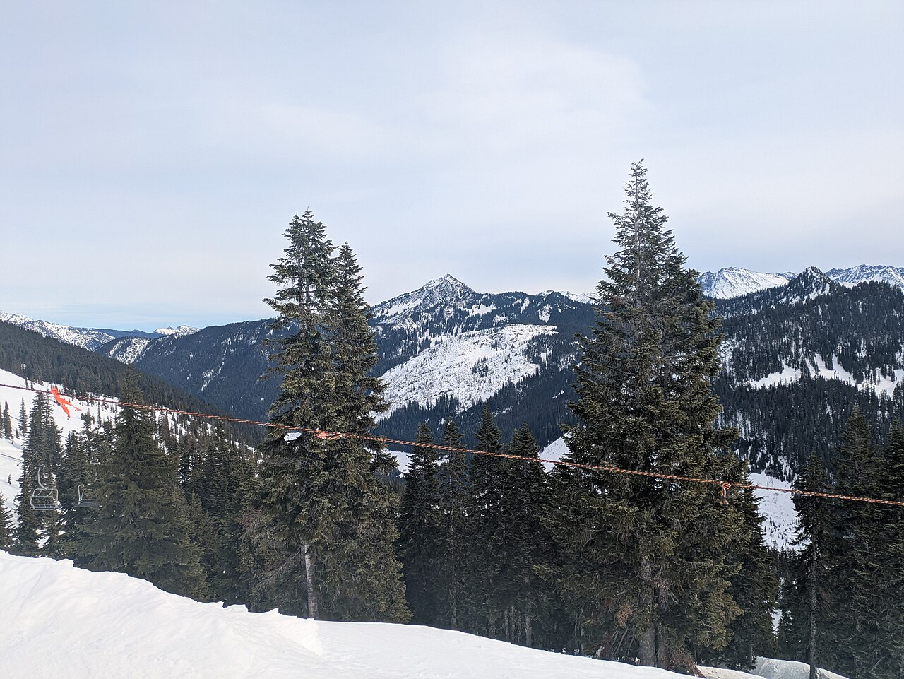
Stevens Pass is a downhill ski area in Washington, United States. Mapped terrain includes beginner, easy, intermediate, advanced, expert routes. Its mapped lift network extends from approximately 1166 to 1727 metres above sea level.
Data: OpenSkiData / OpenSkiMap, OpenStreetMap contributors (ODbL), Skimap.org, Who's On First, Mapterhorn.
正在准备预报图表…
时间和数值与详细预报一致。点击数值查看详情,横向滚动查看后续日期。降水量为每时段总水当量,包含降雪;新雪量指每时段新增降雪,并非地面积雪深度。
GFS与ECMWF模式对比。各模式保留各自的预报时间和时长。降水量和降雪量对应各模式自身的时段,模式之间的时段可能不同。
预报数值与模式说明
Stevens Pass - Base lift station
ECMWF · 模式起报时间: 预计下次更新:
日期 时间(UTC) 气温(°C) 湿度(%) 风速(km/h) 风速(节) 风力(Bft) 风向 降水(mm) 新雪(cm) 气压(hPa) 零度层(m) 天气状况 | 星期三, 04/11 06:00 -0.2 85 1 1 0B SE — — 1020 < 1272 Clear 0% cloud 09:00 1.3 76 1 0 0B S 0 0 1019 2360 Clear 0% cloud 12:00 0.4 78 1 1 1B E 0 0 1019 1512 Clear 0% cloud 15:00 -0.7 80 3 1 1B E 0 0 1019 < 1272 Clear 4% cloud 18:00 7.5 58 3 2 1B NE 0 0 1017 2768 Cloudy 78% cloud 21:00 9.6 53 2 1 1B N 0 0 1015 2691 Overcast 96% cloud 星期四, 05/11 00:00 5 78 1 0 0B N 0 0 1016 2333 Overcast 100% cloud 03:00 3.6 82 2 1 1B SW 0 0 1017 1985 Overcast 100% cloud 06:00 2.4 94 3 1 1B SW 1.5 0 1019 1770 Overcast 100% cloud 09:00 2.2 96 5 3 1B SW 2.0 0 1020 1676 Overcast 100% cloud 12:00 2.1 98 8 4 2B SW 0.55 0 1021 1618 Overcast 100% cloud 15:00 1.6 97 5 3 1B W 1.4 0 1023 1540 Overcast 100% cloud 18:00 2.3 98 8 4 2B SW 0.50 0 1025 1645 Overcast 95% cloud 21:00 4.8 70 9 5 2B W 0.09 0 1024 2145 Cloudy 78% cloud 星期五, 06/11 00:00 3.6 79 3 2 1B W 0 0 1024 1973 Partly cloudy 26% cloud 03:00 -0.6 91 2 1 1B S 0 0 1024 < 1272 Overcast 97% cloud 06:00 -1.3 85 2 1 1B SE 0 0 1024 < 1272 Cloudy 63% cloud 09:00 -1.9 83 4 2 1B E 0 0 1023 < 1272 Cloudy 67% cloud 12:00 1.4 73 3 2 1B SE 0 0 1021 1912 Overcast 100% cloud 15:00 1.2 89 2 1 1B E 0.73 0 1023 1932 Overcast 100% cloud 18:00 2.5 93 4 2 1B E 2.1 0 1022 2505 Overcast 100% cloud 21:00 6 88 1 1 1B SE 0.56 0 1020 2916 Overcast 100% cloud 星期六, 07/11 00:00 4.8 91 2 1 1B SE 3.4 0 1018 3049 Overcast 100% cloud 03:00 4.4 94 3 2 1B SW 6.9 0 1021 2387 Overcast 100% cloud 06:00 4.6 95 4 2 1B SW 1.5 0 1021 2384 Overcast 100% cloud 09:00 4.6 96 4 2 1B SW 0.29 0 1021 2758 Cloudy 79% cloud 12:00 2.9 95 3 1 1B SE 0.00 0 1019 2483 Partly cloudy 28% cloud 15:00 1.8 85 6 3 2B E 0 0 1019 2802 Overcast 90% cloud 18:00 6.4 88 9 5 2B E 0 0 1019 3085 Overcast 99% cloud 21:00 8.9 77 10 5 2B E 0 0 1016 3075 Overcast 98% cloud 星期日, 08/11 00:00 6.6 88 9 5 2B E 0 0 1015 3060 Overcast 97% cloud 03:00 3.2 94 7 4 2B E 0 0 1013 2514 Overcast 96% cloud 06:00 3.9 78 8 4 2B SE 0 0 1010 2700 Overcast 84% cloud 09:00 5.2 89 11 6 2B SW 2.1 0 1010 2380 Overcast 100% cloud 12:00 4 97 15 8 3B SW 8.9 0 1014 1897 Overcast 98% cloud 15:00 2.6 98 17 9 3B SW 2.4 0 1017 1668 Overcast 93% cloud 18:00 3 95 17 9 3B SW 2.3 0 1021 1708 Overcast 97% cloud 21:00 3.2 93 13 7 3B W 1.7 0 1022 1730 Overcast 94% cloud 星期一, 09/11 00:00 2.4 96 8 4 2B W 0.89 0 1024 1627 Overcast 100% cloud 03:00 1.4 95 5 3 1B SW 0.12 0 1025 1518 Overcast 100% cloud 06:00 0.2 95 2 1 1B S 0 0 1025 1295 Overcast 100% cloud 09:00 -2.3 94 2 1 1B E 0 0 1024 < 1272 Clear 10% cloud 12:00 -2.3 89 5 3 1B E 0 0 1022 < 1272 Clear 12% cloud 15:00 -2.1 87 4 2 1B E 0 0 1022 < 1272 Overcast 98% cloud 18:00 3.5 72 5 3 1B E 0 0 1022 2154 Overcast 99% cloud 21:00 6.5 57 5 3 1B E 0 0 1020 2291 Overcast 93% cloud 星期二, 10/11 00:00 3.8 74 4 2 1B E 0 0 1020 1981 Overcast 84% cloud 03:00 0.9 85 4 2 1B E 0 0 1020 1573 Cloudy 63% cloud 06:00 1 83 4 2 1B E 0 0 1019 1670 Overcast 80% cloud |
|---|
Forecast notes
Forecast table times: UTC.
Coordinates: 47.7439747°N, -121.0925512°E · Requested elevation: 1237 m. Model terrain: 1270 m. Terrain and 1000/925/850/700 hPa profiles are used for height estimates.
Outside the available profile, temperature uses an estimated 5.5°C/km height correction; wind retains the nearest available model-level value. Humidity is estimated with adjusted pressure and temperature.
These are altitude estimates, not a simulation of local mountain terrain. Precipitation, cloud and sea-level pressure use horizontal interpolation only.
Precipitation includes rain and snow water equivalent: preceding 3 hours through day 6, then 6 hours (see cell tooltip). Snow (cm) estimates fresh snowfall from precipitation and temperature using the GFS conversion; it is not snow depth on the ground. Freezing (m) uses additional 600/500 hPa temperatures when available and estimates the lowest resolved 0°C crossing above sea level. When all sampled levels are warm, the upper profile limit is shown (see tooltip). < marks an entirely cold sampled profile and its lower height limit. No extrapolation is used.
正在准备预报图表…
时间和数值与详细预报一致。点击数值查看详情,横向滚动查看后续日期。降水量为每时段总水当量,包含降雪;新雪量指每时段新增降雪,并非地面积雪深度。
GFS与ECMWF模式对比。各模式保留各自的预报时间和时长。降水量和降雪量对应各模式自身的时段,模式之间的时段可能不同。
预报数值与模式说明
Stevens Pass - Top lift station
ECMWF · 模式起报时间: 预计下次更新:
日期 时间(UTC) 气温(°C) 湿度(%) 风速(km/h) 风速(节) 风力(Bft) 风向 降水(mm) 新雪(cm) 气压(hPa) 零度层(m) 天气状况 | 星期三, 04/11 06:00 -0.7 81 5 3 1B SW — — 1020 < 1266 Clear 1% cloud 09:00 0.5 73 5 3 1B SW 0 0 1019 2281 Clear 0% cloud 12:00 -0.3 74 4 2 1B W 0 0 1019 1395 Clear 0% cloud 15:00 -1 76 3 2 1B S 0 0 1019 < 1266 Clear 5% cloud 18:00 5.1 61 5 3 1B S 0 0 1017 2770 Cloudy 78% cloud 21:00 6.4 56 8 4 2B S 0 0 1015 2690 Overcast 97% cloud 星期四, 05/11 00:00 2.8 78 8 4 2B SW 0 0 1016 2333 Overcast 100% cloud 03:00 1.2 82 11 6 2B SW 0 0 1017 1984 Overcast 100% cloud 06:00 0.2 95 16 9 3B SW 1.5 0.4 1019 1777 Overcast 100% cloud 09:00 -0.3 92 16 9 3B SW 2.1 0.6 1020 1678 Overcast 100% cloud 12:00 -0.6 92 16 9 3B W 0.57 0.2 1021 1616 Overcast 100% cloud 15:00 -1 92 13 7 3B W 1.4 0.4 1023 1540 Overcast 100% cloud 18:00 -0.5 91 14 8 3B W 0.50 0.2 1025 1646 Overcast 95% cloud 21:00 2.2 64 15 8 3B W 0.10 0 1024 2143 Cloudy 78% cloud 星期五, 06/11 00:00 1.2 71 12 6 2B W 0 0 1024 1976 Partly cloudy 27% cloud 03:00 -1.5 85 8 4 2B W 0 0 1024 < 1266 Overcast 96% cloud 06:00 -2.1 75 8 5 2B SW 0 0 1024 < 1266 Cloudy 65% cloud 09:00 -2.2 80 11 6 2B SW 0 0 1023 < 1266 Cloudy 68% cloud 12:00 0.3 79 15 8 3B SW 0 0 1021 1894 Overcast 100% cloud 15:00 0.3 92 17 9 3B SW 0.71 0.2 1023 1931 Overcast 100% cloud 18:00 1.5 94 14 8 3B W 2.0 0 1022 2510 Overcast 100% cloud 21:00 4.2 91 17 9 3B W 0.55 0 1020 2911 Overcast 100% cloud 星期六, 07/11 00:00 3.4 94 22 12 4B SW 3.4 0 1018 3055 Overcast 100% cloud 03:00 2.5 84 16 9 3B W 6.8 0 1021 2386 Overcast 100% cloud 06:00 2.6 89 14 8 3B W 1.6 0 1021 2390 Overcast 100% cloud 09:00 3.1 91 15 8 3B SW 0.31 0 1021 2758 Cloudy 77% cloud 12:00 1.7 95 16 8 3B SW 0.00 0 1019 2501 Partly cloudy 27% cloud 15:00 1.1 82 10 5 2B SW 0 0 1018 2828 Overcast 90% cloud 18:00 5.1 76 11 6 2B S 0 0 1019 3085 Overcast 99% cloud 21:00 7.1 69 13 7 3B S 0 0 1016 3075 Overcast 98% cloud 星期日, 08/11 00:00 5.1 79 15 8 3B S 0 0 1015 3060 Overcast 98% cloud 03:00 1.9 90 17 9 3B S 0 0 1013 2512 Overcast 96% cloud 06:00 2.5 73 27 15 4B SW 0 0 1010 2702 Overcast 84% cloud 09:00 3 92 34 18 5B SW 2.2 0 1010 2381 Overcast 100% cloud 12:00 1.1 96 38 20 5B SW 8.9 3.6 1014 1899 Overcast 98% cloud 15:00 -0.3 95 38 21 5B SW 2.5 0.7 1017 1672 Overcast 94% cloud 18:00 -0.2 89 35 19 5B W 2.3 0.7 1021 1705 Overcast 97% cloud 21:00 0 90 28 15 4B W 1.8 0.5 1022 1730 Overcast 94% cloud 星期一, 09/11 00:00 -0.6 93 19 10 3B W 0.92 0.3 1024 1630 Overcast 100% cloud 03:00 -1.1 86 13 7 3B W 0.12 0 1025 1519 Overcast 100% cloud 06:00 -1.3 77 6 3 2B W 0 0 1025 1309 Overcast 100% cloud 09:00 -3 71 4 2 1B S 0 0 1024 < 1266 Clear 12% cloud 12:00 -2.6 66 6 3 2B S 0 0 1022 < 1266 Clear 13% cloud 15:00 -2.7 68 6 3 2B S 0 0 1022 < 1266 Overcast 98% cloud 18:00 1.6 66 7 4 2B S 0 0 1022 2157 Overcast 99% cloud 21:00 3.5 58 8 4 2B SW 0 0 1020 2294 Overcast 93% cloud 星期二, 10/11 00:00 1.3 73 11 6 2B SW 0 0 1020 1992 Overcast 83% cloud 03:00 -0.3 88 10 6 2B SW 0 0 1020 1577 Cloudy 66% cloud 06:00 -0.1 87 14 7 3B SW 0 0 1019 1669 Overcast 80% cloud |
|---|
Forecast notes
Forecast table times: UTC.
Coordinates: 47.7336055°N, -121.1039343°E · Requested elevation: 1727 m. Model terrain: 1264 m. Terrain and 1000/925/850/700 hPa profiles are used for height estimates.
These are altitude estimates, not a simulation of local mountain terrain. Precipitation, cloud and sea-level pressure use horizontal interpolation only.
Precipitation includes rain and snow water equivalent: preceding 3 hours through day 6, then 6 hours (see cell tooltip). Snow (cm) estimates fresh snowfall from precipitation and temperature using the GFS conversion; it is not snow depth on the ground. Freezing (m) uses additional 600/500 hPa temperatures when available and estimates the lowest resolved 0°C crossing above sea level. When all sampled levels are warm, the upper profile limit is shown (see tooltip). < marks an entirely cold sampled profile and its lower height limit. No extrapolation is used.