Worldwide Ski Resort Forecasts

Colour guide Temperature · Wind · Rain · Snow
Each colour starts at the value shown. Wind colours match across all three units. Dry cells stay neutral. Colours describe the displayed values, not official weather warnings.
Preparing forecast graphs…
Times and values match the detailed forecast. Tap or point at a value for details. Scroll each chart sideways for later days. Rain / precipitation is the total water equivalent per forecast interval, including snow; snowfall is fresh snow per interval, not snow depth.
GFS and ECMWF model comparison. Each model retains its own forecast times and horizon. Precipitation and snowfall amounts cover their own forecast intervals; these can differ between models.
Forecast values and model notes
Prato Selva - Base lift station
ECMWF · Model run: Next update expected:
Day Local time Temp. (°C) Humidity (%) Wind (km/h) Wind (knots) Wind (Bft) Direction Precip. (mm) Snow (cm) Pressure (hPa) Freezing (m) Conditions | Wednesday, 04/11 07:00 2.8 89 3 2 1B E — — 1022 2418 Cloudy 57% cloud  10:00 6 81 6 3 2B E 0 0 1023 2431 Overcast 97% cloud  13:00 6.9 80 5 3 1B E 0.17 0 1023 2511 Overcast 95% cloud 16:00 5.5 93 6 3 1B NE 0.09 0 1024 2427 Overcast 100% cloud 19:00 4.4 98 4 2 1B E 0.02 0 1025 2369 Overcast 98% cloud 22:00 3.8 96 4 2 1B E 0.01 0 1027 2380 Overcast 97% cloud Thursday, 05/11 01:00 3.7 95 4 2 1B E 0 0 1027 2406 Overcast 98% cloud 04:00 3.3 94 3 2 1B E 0 0 1027 2548 Overcast 100% cloud 07:00 3.4 91 3 2 1B E 0 0 1027 2619 Overcast 100% cloud 10:00 6 82 5 3 1B E 0 0 1027 2717 Cloudy 54% cloud 13:00 7.9 74 5 3 1B E 0 0 1025 2809 Partly cloudy 42% cloud  16:00 6.4 88 4 2 1B E 0 0 1025 2878 Overcast 88% cloud 19:00 4.6 94 2 1 1B NE 0 0 1026 3016 Overcast 94% cloud 22:00 3.6 84 1 1 1B NE 0 0 1026 3088 Overcast 94% cloud Friday, 06/11 01:00 3.1 79 1 0 0B NE 0 0 1025 3033 Cloudy 52% cloud 04:00 3.3 71 0 0 0B SW 0 0 1023 3059 Partly cloudy 37% cloud 07:00 3.7 73 1 0 0B S 0 0 1023 3039 Overcast 90% cloud 10:00 7.7 63 3 2 1B S 0 0 1022 2974 Overcast 98% cloud 13:00 7.2 86 3 2 1B SE 0.99 0 1021 2912 Overcast 100% cloud 16:00 7.2 91 4 2 1B SE 0.39 0 1020 2897 Overcast 86% cloud 19:00 6.1 93 3 1 1B SE 0 0 1020 2917 Overcast 99% cloud 22:00 5.9 94 3 1 1B SE 0 0 1020 2861 Overcast 100% cloud Saturday, 07/11 01:00 5.4 96 2 1 1B S 0.13 0 1020 2786 Overcast 100% cloud 04:00 5.9 97 3 2 1B SW 1.2 0 1019 2656 Overcast 98% cloud 07:00 6 98 2 1 1B SW 0.01 0 1020 2648 Overcast 99% cloud 10:00 7.5 85 3 2 1B SW 0 0 1021 2619 Clear 20% cloud  13:00 9.7 55 2 1 1B SW 0.03 0 1019 2640 Partly cloudy 33% cloud 16:00 8.3 74 2 1 1B NE 0.05 0 1020 2567 Cloudy 64% cloud 19:00 6.4 98 1 1 1B E 0.12 0 1022 2516 Overcast 97% cloud 22:00 5.4 94 1 1 1B S 0 0 1023 2551 Overcast 99% cloud Sunday, 08/11 01:00 3.9 95 2 1 1B SW 0 0 1023 2541 Overcast 100% cloud 04:00 3.5 94 4 2 1B W 0 0 1023 2539 Overcast 100% cloud 07:00 3.7 88 3 2 1B SW 0 0 1024 2589 Overcast 100% cloud 10:00 6.8 74 4 2 1B SW 0.01 0 1025 2654 Overcast 83% cloud 13:00 8.9 56 8 4 2B SW 0.02 0 1024 2689 Cloudy 68% cloud 16:00 7.8 65 4 2 1B SW 0.04 0 1023 2714 Partly cloudy 30% cloud 19:00 5.3 81 1 0 0B SW 0.06 0 1025 2665 Partly cloudy 20% cloud 22:00 5 81 2 1 1B SW 0.03 0 1026 2648 Partly cloudy 21% cloud Monday, 09/11 01:00 4.4 83 3 2 1B SW 0 0 1026 2646 Clear 10% cloud 04:00 3.7 79 2 1 1B SW 0 0 1025 2657 Overcast 96% cloud 07:00 3.5 77 3 2 1B W 0 0 1026 2648 Overcast 99% cloud 10:00 7 60 4 2 1B SW 0 0 1026 2725 Overcast 99% cloud 13:00 9.8 48 6 3 2B SW 0 0 1024 2850 Partly cloudy 46% cloud 16:00 8.4 58 7 4 2B SW 0 0 1024 2897 Overcast 81% cloud 19:00 6.1 64 6 3 1B SW 0 0 1024 3005 Overcast 84% cloud 22:00 5.5 67 8 4 2B SW 0 0 1024 3047 Cloudy 68% cloud Tuesday, 10/11 01:00 5.9 85 9 5 2B SW 0 0 1024 3125 Overcast 99% cloud 04:00 6.4 97 9 5 2B SW 0.00 0 1021 3112 Overcast 100% cloud 07:00 6.9 97 9 5 2B SW 0.12 0 1021 3110 Overcast 100% cloud |
|---|
Forecast notes
Forecast table times: Europe/Rome.
Coordinates: 42.523784°N, 13.4892302°E · Requested elevation: 1376 m. Model terrain: 1299 m. Terrain and 1000/925/850/700 hPa profiles are used for height estimates.
These are altitude estimates, not a simulation of local mountain terrain. Precipitation, cloud and sea-level pressure use horizontal interpolation only.
Precipitation includes rain and snow water equivalent: preceding 3 hours through day 6, then 6 hours (see cell tooltip). Snow (cm) estimates fresh snowfall from precipitation and temperature using the GFS conversion; it is not snow depth on the ground. Freezing (m) uses additional 600/500 hPa temperatures when available and estimates the lowest resolved 0°C crossing above sea level. When all sampled levels are warm, the upper profile limit is shown (see tooltip). < marks an entirely cold sampled profile and its lower height limit. No extrapolation is used.
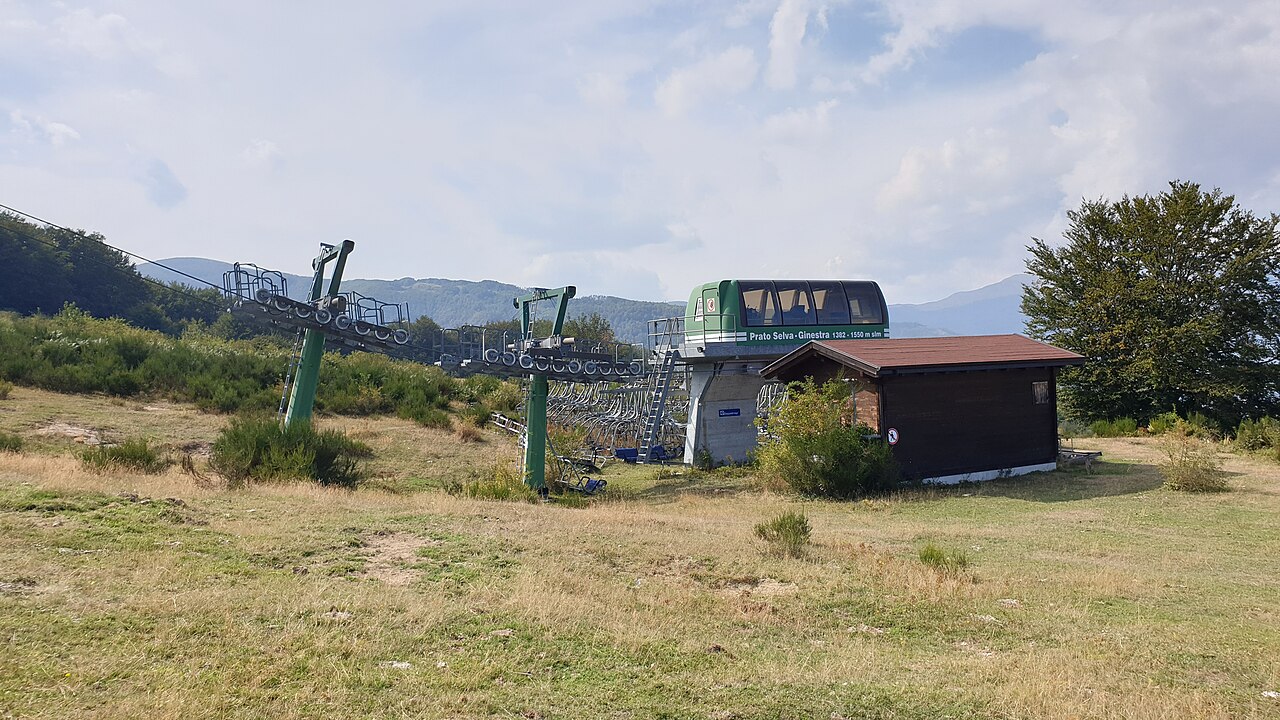
Prato Selva is a mapped downhill ski area in IT. Forecasts cover three real lift-station locations from approximately 1376 to 1772 metres. Elevations are terrain-model estimates.
Data: OpenSkiData / OpenSkiMap, OpenStreetMap contributors (ODbL), Skimap.org, Who's On First, Mapterhorn.
Preparing forecast graphs…
Times and values match the detailed forecast. Tap or point at a value for details. Scroll each chart sideways for later days. Rain / precipitation is the total water equivalent per forecast interval, including snow; snowfall is fresh snow per interval, not snow depth.
GFS and ECMWF model comparison. Each model retains its own forecast times and horizon. Precipitation and snowfall amounts cover their own forecast intervals; these can differ between models.
Forecast values and model notes
Prato Selva - Middle lift station
ECMWF · Model run: Next update expected:
Day Local time Temp. (°C) Humidity (%) Wind (km/h) Wind (knots) Wind (Bft) Direction Precip. (mm) Snow (cm) Pressure (hPa) Freezing (m) Conditions | Wednesday, 04/11 07:00 3.8 78 6 3 2B E — — 1022 2417 Cloudy 58% cloud 10:00 3.7 89 7 4 2B E 0 0 1023 2433 Overcast 98% cloud 13:00 4.9 86 4 2 1B E 0.17 0 1023 2515 Overcast 96% cloud 16:00 4.1 97 7 4 2B E 0.08 0 1024 2428 Overcast 100% cloud 19:00 3.5 98 5 3 1B E 0.02 0 1025 2367 Overcast 99% cloud 22:00 3.2 92 7 4 2B E 0.01 0 1027 2377 Overcast 98% cloud Thursday, 05/11 01:00 3 97 8 4 2B E 0 0 1027 2404 Overcast 99% cloud 04:00 3.2 89 8 4 2B E 0 0 1027 2547 Overcast 100% cloud 07:00 3.4 80 8 4 2B E 0 0 1027 2618 Overcast 100% cloud 10:00 4 88 6 4 2B E 0 0 1027 2717 Cloudy 54% cloud 13:00 5.4 82 6 3 1B E 0 0 1025 2810 Partly cloudy 42% cloud 16:00 4.9 94 4 2 1B E 0 0 1025 2879 Overcast 88% cloud 19:00 4.8 85 3 1 1B E 0 0 1026 3016 Overcast 95% cloud 22:00 5.2 58 2 1 1B E 0 0 1026 3089 Overcast 94% cloud Friday, 06/11 01:00 5.7 54 3 2 1B E 0 0 1025 3033 Cloudy 51% cloud 04:00 6.3 44 3 2 1B S 0 0 1023 3059 Partly cloudy 35% cloud 07:00 6.2 59 3 1 1B S 0 0 1023 3038 Overcast 90% cloud 10:00 6.4 59 5 3 1B S 0 0 1022 2974 Overcast 98% cloud 13:00 6.7 73 4 2 1B SE 0.98 0 1021 2912 Overcast 100% cloud 16:00 6.8 85 6 3 2B SE 0.38 0 1020 2898 Overcast 85% cloud 19:00 6.7 84 6 3 2B SE 0 0 1020 2919 Overcast 99% cloud 22:00 6.8 85 5 3 1B S 0 0 1020 2861 Overcast 100% cloud Saturday, 07/11 01:00 6.5 89 5 3 1B S 0.13 0 1020 2787 Overcast 100% cloud 04:00 5.9 97 6 3 2B SW 1.2 0 1019 2654 Overcast 99% cloud 07:00 5.4 100 6 3 1B SW 0.01 0 1020 2648 Overcast 98% cloud 10:00 5.6 89 5 3 1B SW 0 0 1021 2621 Clear 17% cloud 13:00 7.4 58 4 2 1B W 0.02 0 1019 2642 Partly cloudy 30% cloud 16:00 6.8 75 1 1 0B S 0.03 0 1019 2569 Cloudy 64% cloud 19:00 5.6 98 2 1 1B S 0.12 0 1022 2516 Overcast 98% cloud 22:00 6 83 4 2 1B S 0 0 1023 2553 Overcast 99% cloud Sunday, 08/11 01:00 5.7 85 6 3 2B SW 0 0 1023 2543 Overcast 100% cloud 04:00 5.4 83 7 4 2B SW 0 0 1023 2540 Overcast 100% cloud 07:00 5.3 65 7 4 2B SW 0 0 1024 2591 Overcast 100% cloud 10:00 5.3 72 6 3 2B SW 0.01 0 1025 2655 Overcast 83% cloud 13:00 6.8 58 10 6 2B SW 0.02 0 1024 2691 Cloudy 67% cloud 16:00 6.3 66 7 4 2B SW 0.03 0 1023 2716 Partly cloudy 28% cloud 19:00 5.2 74 3 1 1B SW 0.04 0 1025 2667 Clear 18% cloud 22:00 4.9 76 5 3 1B SW 0.02 0 1026 2649 Clear 19% cloud Monday, 09/11 01:00 4.5 83 8 4 2B W 0 0 1026 2649 Clear 8% cloud 04:00 4.7 59 5 3 1B SW 0 0 1025 2660 Overcast 95% cloud 07:00 5.1 54 6 3 2B W 0 0 1026 2649 Overcast 99% cloud 10:00 6.1 45 6 3 2B SW 0 0 1026 2726 Overcast 100% cloud 13:00 7.6 50 9 5 2B SW 0 0 1024 2850 Partly cloudy 46% cloud 16:00 7.4 55 12 6 2B W 0 0 1024 2897 Overcast 80% cloud 19:00 7.2 46 10 6 2B SW 0 0 1024 3006 Overcast 84% cloud 22:00 7.5 52 16 9 3B SW 0 0 1024 3049 Cloudy 68% cloud Tuesday, 10/11 01:00 6.8 91 20 11 3B SW 0 0 1024 3125 Overcast 99% cloud 04:00 7.4 95 17 9 3B SW 0.00 0 1021 3112 Overcast 100% cloud 07:00 7.6 93 18 10 3B SW 0.12 0 1021 3110 Overcast 100% cloud |
|---|
Forecast notes
Forecast table times: Europe/Rome.
Coordinates: 42.5160128°N, 13.4930202°E · Requested elevation: 1540 m. Model terrain: 1317 m. Terrain and 1000/925/850/700 hPa profiles are used for height estimates.
These are altitude estimates, not a simulation of local mountain terrain. Precipitation, cloud and sea-level pressure use horizontal interpolation only.
Precipitation includes rain and snow water equivalent: preceding 3 hours through day 6, then 6 hours (see cell tooltip). Snow (cm) estimates fresh snowfall from precipitation and temperature using the GFS conversion; it is not snow depth on the ground. Freezing (m) uses additional 600/500 hPa temperatures when available and estimates the lowest resolved 0°C crossing above sea level. When all sampled levels are warm, the upper profile limit is shown (see tooltip). < marks an entirely cold sampled profile and its lower height limit. No extrapolation is used.
Preparing forecast graphs…
Times and values match the detailed forecast. Tap or point at a value for details. Scroll each chart sideways for later days. Rain / precipitation is the total water equivalent per forecast interval, including snow; snowfall is fresh snow per interval, not snow depth.
GFS and ECMWF model comparison. Each model retains its own forecast times and horizon. Precipitation and snowfall amounts cover their own forecast intervals; these can differ between models.
Forecast values and model notes
Prato Selva - Top lift station
ECMWF · Model run: Next update expected:
Day Local time Temp. (°C) Humidity (%) Wind (km/h) Wind (knots) Wind (Bft) Direction Precip. (mm) Snow (cm) Pressure (hPa) Freezing (m) Conditions | Wednesday, 04/11 07:00 2.8 72 4 2 1B E — — 1022 2418 Cloudy 59% cloud 10:00 2.7 82 5 3 1B E 0 0 1023 2436 Overcast 99% cloud 13:00 3.7 80 3 2 1B SE 0.18 0 1023 2520 Overcast 96% cloud 16:00 3.1 91 5 3 1B E 0.07 0 1024 2430 Overcast 100% cloud 19:00 2.5 93 4 2 1B E 0.01 0 1025 2367 Overcast 99% cloud 22:00 2.3 88 6 3 2B E 0.00 0 1027 2375 Overcast 99% cloud Thursday, 05/11 01:00 2.2 91 6 3 2B E 0 0 1027 2403 Overcast 99% cloud 04:00 2.5 82 6 3 2B E 0 0 1027 2546 Overcast 100% cloud 07:00 2.7 74 6 4 2B E 0 0 1027 2618 Overcast 100% cloud 10:00 3 84 5 3 1B E 0 0 1027 2719 Cloudy 53% cloud 13:00 4.2 79 4 2 1B E 0 0 1025 2812 Partly cloudy 42% cloud 16:00 4 87 4 2 1B E 0 0 1025 2881 Overcast 89% cloud 19:00 4.1 78 2 1 1B E 0 0 1026 3015 Overcast 95% cloud 22:00 4.5 52 2 1 1B E 0 0 1026 3089 Overcast 94% cloud Friday, 06/11 01:00 4.9 50 2 1 1B SE 0 0 1025 3033 Partly cloudy 50% cloud 04:00 5.4 43 3 2 1B S 0 0 1023 3058 Partly cloudy 33% cloud 07:00 5.2 60 3 2 1B S 0 0 1023 3036 Overcast 89% cloud 10:00 5.4 63 7 4 2B S 0 0 1022 2973 Overcast 98% cloud 13:00 5.5 76 6 3 2B S 0.99 0 1021 2913 Overcast 100% cloud 16:00 5.6 87 5 3 1B S 0.37 0 1020 2899 Overcast 85% cloud 19:00 5.6 85 5 2 1B S 0 0 1020 2921 Overcast 100% cloud 22:00 5.6 85 5 3 1B S 0 0 1020 2861 Overcast 100% cloud Saturday, 07/11 01:00 5.3 89 6 3 2B SW 0.13 0 1020 2787 Overcast 100% cloud 04:00 4.7 98 7 4 2B SW 1.2 0 1019 2653 Overcast 100% cloud 07:00 4.3 93 7 4 2B SW 0.00 0 1020 2649 Overcast 98% cloud 10:00 4.4 81 6 3 2B SW 0 0 1021 2622 Clear 13% cloud 13:00 5.9 56 5 3 1B W 0.01 0 1019 2645 Partly cloudy 27% cloud 16:00 5.3 76 3 2 1B SW 0.01 0 1019 2571 Cloudy 64% cloud 19:00 4.3 95 3 1 1B SW 0.12 0 1022 2517 Overcast 98% cloud 22:00 4.6 80 4 2 1B S 0 0 1023 2554 Overcast 100% cloud Sunday, 08/11 01:00 4.4 81 7 4 2B SW 0 0 1023 2545 Overcast 100% cloud 04:00 4.1 76 8 4 2B SW 0 0 1023 2541 Overcast 100% cloud 07:00 4.2 59 9 5 2B SW 0 0 1024 2593 Overcast 100% cloud 10:00 4.1 67 9 5 2B SW 0.00 0 1025 2657 Overcast 84% cloud 13:00 5.4 54 13 7 3B W 0.01 0 1023 2692 Cloudy 67% cloud 16:00 5.1 61 10 5 2B SW 0.01 0 1023 2718 Partly cloudy 25% cloud 19:00 4.2 69 5 3 1B SW 0.01 0 1025 2668 Clear 14% cloud 22:00 4 72 7 4 2B SW 0.01 0 1026 2650 Clear 16% cloud Monday, 09/11 01:00 3.6 80 9 5 2B W 0 0 1026 2653 Clear 6% cloud 04:00 3.8 57 7 4 2B W 0 0 1025 2664 Overcast 95% cloud 07:00 4.2 54 9 5 2B W 0 0 1026 2649 Overcast 99% cloud 10:00 4.9 46 9 5 2B W 0 0 1026 2728 Overcast 100% cloud 13:00 6.2 52 12 6 2B W 0 0 1024 2850 Partly cloudy 45% cloud 16:00 6.2 54 15 8 3B W 0 0 1024 2898 Cloudy 80% cloud 19:00 6.1 45 12 7 3B SW 0 0 1024 3006 Overcast 84% cloud 22:00 6.6 51 18 10 3B SW 0 0 1024 3051 Cloudy 68% cloud Tuesday, 10/11 01:00 5.9 86 21 12 4B SW 0 0 1024 3125 Overcast 100% cloud 04:00 6.5 89 19 10 3B SW 0.00 0 1021 3112 Overcast 100% cloud 07:00 6.7 89 19 10 3B SW 0.12 0 1021 3111 Overcast 100% cloud |
|---|
Forecast notes
Forecast table times: Europe/Rome.
Coordinates: 42.5061676°N, 13.4945461°E · Requested elevation: 1772 m. Model terrain: 1339 m. Terrain and 1000/925/850/700 hPa profiles are used for height estimates.
These are altitude estimates, not a simulation of local mountain terrain. Precipitation, cloud and sea-level pressure use horizontal interpolation only.
Precipitation includes rain and snow water equivalent: preceding 3 hours through day 6, then 6 hours (see cell tooltip). Snow (cm) estimates fresh snowfall from precipitation and temperature using the GFS conversion; it is not snow depth on the ground. Freezing (m) uses additional 600/500 hPa temperatures when available and estimates the lowest resolved 0°C crossing above sea level. When all sampled levels are warm, the upper profile limit is shown (see tooltip). < marks an entirely cold sampled profile and its lower height limit. No extrapolation is used.