Worldwide Ski Resort Forecasts

Colour guide Temperature · Wind · Rain · Snow
Each colour starts at the value shown. Wind colours match across all three units. Dry cells stay neutral. Colours describe the displayed values, not official weather warnings.
Preparing forecast graphs…
Times and values match the detailed forecast. Tap or point at a value for details. Scroll each chart sideways for later days. Rain / precipitation is the total water equivalent per forecast interval, including snow; snowfall is fresh snow per interval, not snow depth.
GFS and ECMWF model comparison. Each model retains its own forecast times and horizon. Precipitation and snowfall amounts cover their own forecast intervals; these can differ between models.
Forecast values and model notes
Prato Nevoso - Low lift station
ECMWF · Model run: Next update expected:
Day Time (UTC) Temp. (°C) Humidity (%) Wind (km/h) Wind (knots) Wind (Bft) Direction Precip. (mm) Snow (cm) Pressure (hPa) Freezing (m) Conditions | Wednesday, 04/11 06:00 1 97 19 10 3B NE — — 1024 1650 Overcast 100% cloud  09:00 0.9 97 16 9 3B N 3.8 1.5 1025 1636 Overcast 100% cloud 12:00 0.8 96 12 6 2B N 4.1 1.6 1026 1634 Overcast 100% cloud 15:00 0.5 96 12 6 2B N 3.5 1.4 1027 1598 Overcast 100% cloud 18:00 0.6 96 11 6 2B N 2.4 0.7 1027 1642 Overcast 100% cloud 21:00 0.8 95 10 5 2B N 3.4 1.4 1029 1714 Overcast 100% cloud Thursday, 05/11 00:00 0.7 95 11 6 2B N 4.7 1.9 1029 1685 Overcast 100% cloud 03:00 0.6 95 12 7 2B NW 6.6 2 1029 1696 Overcast 100% cloud 06:00 0.6 96 13 7 3B NW 6.4 2 1030 1689 Overcast 100% cloud 09:00 0.9 96 12 7 3B NW 3.8 1.5 1031 1747 Overcast 100% cloud 12:00 1.2 94 12 7 3B NW 2.7 0 1030 1850 Overcast 100% cloud 15:00 1.6 92 10 5 2B N 3.1 0 1029 2070 Overcast 100% cloud 18:00 1.9 91 8 4 2B N 1.7 0 1028 2220 Overcast 100% cloud 21:00 1.9 91 8 5 2B N 2.0 0 1028 2172 Overcast 100% cloud Friday, 06/11 00:00 1.4 94 9 5 2B N 3.4 0 1027 2010 Overcast 100% cloud 03:00 1.4 94 9 5 2B N 3.2 0 1026 2052 Overcast 100% cloud 06:00 1.4 95 11 6 2B N 2.4 0 1025 2061 Overcast 100% cloud 09:00 1.7 93 10 6 2B N 2.6 0 1025 2069 Overcast 100% cloud 12:00 1.8 92 11 6 2B N 2.5 0 1024 2054 Overcast 100% cloud 15:00 1.5 95 11 6 2B NW 0.84 0 1023 1941 Overcast 100% cloud 18:00 1.3 92 11 6 2B NW 4.9 0 1023 1850 Overcast 100% cloud 21:00 1.2 95 13 7 3B NW 1.4 0 1023 1783 Overcast 100% cloud Saturday, 07/11 00:00 0.9 95 13 7 3B NW 3.2 1.3 1023 1727 Overcast 100% cloud 03:00 0.8 96 15 8 3B NW 0.00 0 1023 1675 Overcast 100% cloud 06:00 1 94 13 7 3B NW 0.00 0 1024 1705 Overcast 96% cloud 09:00 1.3 94 14 7 3B NW 0 0 1025 1717 Overcast 99% cloud 12:00 1.8 92 11 6 2B NW 0.01 0 1024 1768 Overcast 100% cloud 15:00 1.4 96 10 6 2B NW 0.10 0 1025 1758 Overcast 98% cloud 18:00 1.1 97 9 5 2B NW 0 0 1026 1761 Overcast 100% cloud 21:00 0.9 95 8 4 2B NW 0.00 0 1027 1733 Overcast 100% cloud Sunday, 08/11 00:00 0.7 94 5 3 1B NW 0.10 0 1027 1755 Overcast 99% cloud 03:00 0.5 86 1 0 0B NW 0 0 1025 1426 Cloudy 65% cloud  06:00 0.7 71 1 1 1B W 0 0 1025 1397 Cloudy 61% cloud 09:00 2.1 72 1 0 0B SW 0 0 1027 1974 Partly cloudy 29% cloud  12:00 3.5 75 1 1 1B S 0 0 1025 2172 Clear 16% cloud  15:00 3 90 4 2 1B SE 0 0 1025 2207 Cloudy 67% cloud 18:00 2.7 90 4 2 1B S 0 0 1026 2265 Cloudy 73% cloud 21:00 3 92 7 4 2B S 0 0 1025 2423 Overcast 94% cloud Monday, 09/11 00:00 2.9 96 7 4 2B SW 0 0 1025 2605 Overcast 99% cloud 03:00 3 97 6 3 2B S 0 0 1024 2493 Overcast 100% cloud 06:00 3.2 96 7 4 2B S 0.01 0 1024 2641 Overcast 100% cloud 09:00 4 94 9 5 2B S 0.01 0 1025 2706 Overcast 100% cloud 12:00 5 94 9 5 2B S 0.13 0 1023 2776 Overcast 100% cloud 15:00 5 94 9 5 2B S 0.12 0 1022 2911 Overcast 100% cloud 18:00 4.9 94 9 5 2B S 0 0 1022 3057 Overcast 96% cloud 21:00 4.9 92 9 5 2B S 0 0 1022 3099 Overcast 94% cloud Tuesday, 10/11 00:00 5.3 92 10 5 2B S 0 0 1020 3091 Overcast 100% cloud 03:00 5.8 95 11 6 2B S 0.22 0 1018 3075 Overcast 100% cloud 06:00 6.2 94 11 6 2B S 4.0 0 1017 3068 Overcast 100% cloud |
|---|
Forecast notes
Forecast table times: UTC.
Coordinates: 44.2555057°N, 7.780443°E · Requested elevation: 1461 m. Model terrain: 1270 m. Terrain and 1000/925/850/700 hPa profiles are used for height estimates.
These are altitude estimates, not a simulation of local mountain terrain. Precipitation, cloud and sea-level pressure use horizontal interpolation only.
Precipitation includes rain and snow water equivalent: preceding 3 hours through day 6, then 6 hours (see cell tooltip). Snow (cm) estimates fresh snowfall from precipitation and temperature using the GFS conversion; it is not snow depth on the ground. Freezing (m) uses additional 600/500 hPa temperatures when available and estimates the lowest resolved 0°C crossing above sea level. When all sampled levels are warm, the upper profile limit is shown (see tooltip). < marks an entirely cold sampled profile and its lower height limit. No extrapolation is used.
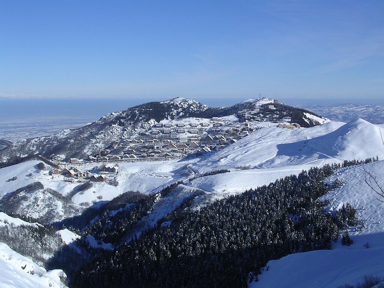
Prato Nevoso is a downhill ski area in Cuneo, Italy. Mapped terrain includes easy, intermediate, advanced routes. Its mapped lift network extends from approximately 1461 to 1921 metres above sea level.
Data: OpenSkiData / OpenSkiMap, OpenStreetMap contributors (ODbL), Skimap.org, Who's On First, Mapterhorn.
Preparing forecast graphs…
Times and values match the detailed forecast. Tap or point at a value for details. Scroll each chart sideways for later days. Rain / precipitation is the total water equivalent per forecast interval, including snow; snowfall is fresh snow per interval, not snow depth.
GFS and ECMWF model comparison. Each model retains its own forecast times and horizon. Precipitation and snowfall amounts cover their own forecast intervals; these can differ between models.
Forecast values and model notes
Prato Nevoso - Base lift station
ECMWF · Model run: Next update expected:
Day Time (UTC) Temp. (°C) Humidity (%) Wind (km/h) Wind (knots) Wind (Bft) Direction Precip. (mm) Snow (cm) Pressure (hPa) Freezing (m) Conditions | Wednesday, 04/11 06:00 1 97 20 11 3B NE — — 1024 1651 Overcast 100% cloud 09:00 0.8 97 16 9 3B N 3.8 1.5 1025 1637 Overcast 100% cloud 12:00 0.8 96 12 6 2B N 4.1 1.6 1026 1635 Overcast 100% cloud 15:00 0.5 96 12 6 2B N 3.5 1.4 1027 1599 Overcast 100% cloud 18:00 0.6 96 12 6 2B N 2.4 0.7 1027 1643 Overcast 100% cloud 21:00 0.8 95 10 5 2B N 3.4 1.4 1029 1715 Overcast 100% cloud Thursday, 05/11 00:00 0.7 95 11 6 2B N 4.7 1.9 1029 1687 Overcast 100% cloud 03:00 0.6 95 12 7 3B NW 6.6 2 1029 1697 Overcast 100% cloud 06:00 0.6 95 13 7 3B NW 6.5 2 1030 1691 Overcast 100% cloud 09:00 0.9 95 12 7 3B NW 3.8 1.5 1031 1749 Overcast 100% cloud 12:00 1.1 94 13 7 3B NW 2.7 0.8 1030 1853 Overcast 100% cloud 15:00 1.6 92 10 5 2B N 3.1 0 1029 2072 Overcast 100% cloud 18:00 1.9 91 8 4 2B N 1.7 0 1028 2221 Overcast 100% cloud 21:00 1.9 91 9 5 2B N 2.0 0 1028 2173 Overcast 100% cloud Friday, 06/11 00:00 1.4 94 9 5 2B N 3.4 0 1027 2012 Overcast 100% cloud 03:00 1.4 94 9 5 2B N 3.3 0 1026 2054 Overcast 100% cloud 06:00 1.4 95 11 6 2B N 2.4 0 1025 2063 Overcast 100% cloud 09:00 1.7 93 11 6 2B N 2.6 0 1025 2070 Overcast 100% cloud 12:00 1.8 92 11 6 2B N 2.5 0 1024 2055 Overcast 100% cloud 15:00 1.5 94 12 6 2B NW 0.84 0 1023 1942 Overcast 100% cloud 18:00 1.3 92 11 6 2B NW 4.9 0 1023 1851 Overcast 100% cloud 21:00 1.2 95 13 7 3B NW 1.4 0 1023 1784 Overcast 100% cloud Saturday, 07/11 00:00 0.9 94 13 7 3B NW 3.2 1.3 1023 1729 Overcast 100% cloud 03:00 0.8 96 15 8 3B NW 0.00 0 1023 1677 Overcast 100% cloud 06:00 0.9 93 14 7 3B NW 0.00 0 1024 1706 Overcast 96% cloud 09:00 1.3 94 14 8 3B NW 0 0 1025 1718 Overcast 99% cloud 12:00 1.7 92 12 6 2B NW 0.02 0 1024 1769 Overcast 100% cloud 15:00 1.4 96 10 6 2B NW 0.10 0 1025 1759 Overcast 98% cloud 18:00 1.1 96 9 5 2B NW 0 0 1026 1762 Overcast 100% cloud 21:00 0.9 95 8 4 2B NW 0.00 0 1027 1734 Overcast 100% cloud Sunday, 08/11 00:00 0.8 94 5 3 1B NW 0.10 0 1027 1756 Overcast 99% cloud 03:00 0.6 86 1 1 0B NW 0 0 1025 1428 Cloudy 65% cloud 06:00 0.8 71 1 1 1B W 0 0 1025 1399 Cloudy 60% cloud 09:00 2.1 72 1 0 0B SW 0 0 1027 1974 Partly cloudy 29% cloud 12:00 3.5 75 1 1 1B S 0 0 1025 2172 Clear 16% cloud 15:00 3 91 4 2 1B SE 0 0 1025 2208 Cloudy 67% cloud 18:00 2.7 90 4 2 1B S 0 0 1026 2266 Cloudy 73% cloud 21:00 3 93 7 4 2B S 0 0 1025 2424 Overcast 94% cloud Monday, 09/11 00:00 2.9 96 7 4 2B SW 0 0 1025 2605 Overcast 99% cloud 03:00 3 97 6 3 2B S 0 0 1024 2493 Overcast 100% cloud 06:00 3.2 96 7 4 2B S 0.02 0 1024 2641 Overcast 100% cloud 09:00 4 94 9 5 2B S 0.02 0 1025 2707 Overcast 100% cloud 12:00 5 94 9 5 2B S 0.14 0 1023 2776 Overcast 100% cloud 15:00 5 94 9 5 2B S 0.12 0 1022 2911 Overcast 100% cloud 18:00 4.9 94 10 5 2B S 0 0 1022 3057 Overcast 96% cloud 21:00 5 92 9 5 2B S 0 0 1022 3099 Overcast 94% cloud Tuesday, 10/11 00:00 5.3 92 10 5 2B S 0 0 1020 3091 Overcast 100% cloud 03:00 5.8 95 11 6 2B S 0.22 0 1018 3075 Overcast 100% cloud 06:00 6.2 94 11 6 2B S 4.0 0 1017 3068 Overcast 100% cloud |
|---|
Forecast notes
Forecast table times: UTC.
Coordinates: 44.2543533°N, 7.7818475°E · Requested elevation: 1465 m. Model terrain: 1272 m. Terrain and 1000/925/850/700 hPa profiles are used for height estimates.
These are altitude estimates, not a simulation of local mountain terrain. Precipitation, cloud and sea-level pressure use horizontal interpolation only.
Precipitation includes rain and snow water equivalent: preceding 3 hours through day 6, then 6 hours (see cell tooltip). Snow (cm) estimates fresh snowfall from precipitation and temperature using the GFS conversion; it is not snow depth on the ground. Freezing (m) uses additional 600/500 hPa temperatures when available and estimates the lowest resolved 0°C crossing above sea level. When all sampled levels are warm, the upper profile limit is shown (see tooltip). < marks an entirely cold sampled profile and its lower height limit. No extrapolation is used.
Preparing forecast graphs…
Times and values match the detailed forecast. Tap or point at a value for details. Scroll each chart sideways for later days. Rain / precipitation is the total water equivalent per forecast interval, including snow; snowfall is fresh snow per interval, not snow depth.
GFS and ECMWF model comparison. Each model retains its own forecast times and horizon. Precipitation and snowfall amounts cover their own forecast intervals; these can differ between models.
Forecast values and model notes
Prato Nevoso - Top lift station
ECMWF · Model run: Next update expected:
Day Time (UTC) Temp. (°C) Humidity (%) Wind (km/h) Wind (knots) Wind (Bft) Direction Precip. (mm) Snow (cm) Pressure (hPa) Freezing (m) Conditions | Wednesday, 04/11 06:00 -1.3 95 23 12 4B NE — — 1024 1678 Overcast 100% cloud 09:00 -1.3 95 17 9 3B NE 3.7 1.5 1025 1664 Overcast 100% cloud 12:00 -1.4 95 11 6 2B NE 3.9 1.6 1026 1661 Overcast 100% cloud 15:00 -1.3 95 5 3 1B NE 3.4 1.3 1026 1639 Overcast 100% cloud 18:00 -1 96 7 4 2B NE 2.3 0.7 1027 1685 Overcast 100% cloud 21:00 -0.7 94 9 5 2B NE 3.4 1.3 1028 1754 Overcast 100% cloud Thursday, 05/11 00:00 -0.7 94 11 6 2B NE 4.6 1.8 1029 1734 Overcast 100% cloud 03:00 -0.6 94 8 5 2B NE 6.7 2.1 1029 1749 Overcast 100% cloud 06:00 -0.6 94 5 3 1B N 6.6 2 1029 1753 Overcast 100% cloud 09:00 -0.3 95 4 2 1B N 3.9 1.6 1030 1816 Overcast 100% cloud 12:00 0 94 5 3 1B N 2.8 0.8 1030 1924 Overcast 100% cloud 15:00 0.6 93 5 3 1B NE 3.1 1.2 1028 2126 Overcast 100% cloud 18:00 1 92 6 3 1B NE 1.7 0.5 1028 2258 Overcast 100% cloud 21:00 0.9 92 7 4 2B NE 2.0 0.6 1028 2211 Overcast 100% cloud Friday, 06/11 00:00 0.4 94 7 4 2B NE 3.4 1.4 1027 2064 Overcast 100% cloud 03:00 0.5 94 7 4 2B E 3.5 1.4 1025 2101 Overcast 100% cloud 06:00 0.5 95 6 3 2B NE 2.6 0.8 1025 2114 Overcast 100% cloud 09:00 0.5 95 2 1 1B NE 2.8 0.8 1025 2113 Overcast 100% cloud 12:00 0.5 92 2 1 1B NW 2.6 0.8 1024 2097 Overcast 100% cloud 15:00 0.2 94 5 3 1B W 0.83 0.2 1023 1979 Overcast 100% cloud 18:00 -0.2 90 12 6 2B W 4.7 1.9 1023 1882 Overcast 99% cloud 21:00 -0.5 89 15 8 3B NW 1.3 0.4 1023 1812 Overcast 98% cloud Saturday, 07/11 00:00 -0.7 92 17 9 3B NW 3.0 1.2 1023 1756 Overcast 97% cloud 03:00 -0.8 91 20 11 3B NW 0.01 0 1023 1709 Overcast 98% cloud 06:00 -0.9 89 15 8 3B NW 0 0 1023 1731 Overcast 95% cloud 09:00 -0.8 88 15 8 3B NW 0 0 1025 1747 Overcast 94% cloud 12:00 -0.6 88 13 7 3B NW 0.01 0 1024 1797 Overcast 97% cloud 15:00 -0.6 86 13 7 3B NW 0.12 0 1024 1784 Overcast 94% cloud 18:00 -0.6 83 12 6 2B NW 0 0 1026 1789 Overcast 96% cloud 21:00 -0.7 82 11 6 2B NW 0 0 1027 1761 Overcast 99% cloud Sunday, 08/11 00:00 -0.6 80 9 5 2B NW 0.10 0 1027 1780 Overcast 98% cloud 03:00 -0.2 71 8 4 2B W 0 0 1025 1411 Cloudy 66% cloud 06:00 0 58 8 4 2B W 0 0 1025 1377 Cloudy 61% cloud 09:00 0.2 62 8 4 2B W 0 0 1026 1991 Partly cloudy 28% cloud 12:00 1.1 72 10 6 2B W 0.01 0 1025 2184 Partly cloudy 20% cloud 15:00 1.1 93 9 5 2B W 0 0 1025 2219 Cloudy 69% cloud 18:00 1.3 90 12 6 2B W 0.01 0 1026 2273 Cloudy 75% cloud 21:00 1.8 90 11 6 2B SW 0.02 0 1025 2432 Overcast 95% cloud Monday, 09/11 00:00 2 90 14 7 3B SW 0 0 1025 2615 Overcast 99% cloud 03:00 1.9 94 14 7 3B SW 0.03 0 1024 2497 Overcast 100% cloud 06:00 2.3 90 14 8 3B SW 0.02 0 1024 2643 Overcast 100% cloud 09:00 2.6 88 16 9 3B SW 0.01 0 1025 2709 Overcast 100% cloud 12:00 3.2 90 18 9 3B SW 0.13 0 1023 2776 Overcast 100% cloud 15:00 3.6 90 18 10 3B SW 0.11 0 1022 2912 Overcast 99% cloud 18:00 4 88 20 11 3B SW 0 0 1022 3050 Overcast 96% cloud 21:00 4.2 90 19 10 3B SW 0 0 1022 3099 Overcast 95% cloud Tuesday, 10/11 00:00 4.4 93 21 11 4B SW 0.01 0 1020 3091 Overcast 100% cloud 03:00 4.8 95 22 12 4B SW 0.27 0 1018 3076 Overcast 100% cloud 06:00 5 93 22 12 4B SW 4.3 0 1017 3068 Overcast 100% cloud |
|---|
Forecast notes
Forecast table times: UTC.
Coordinates: 44.2316695°N, 7.7822232°E · Requested elevation: 1921 m. Model terrain: 1264 m. Terrain and 1000/925/850/700 hPa profiles are used for height estimates.
These are altitude estimates, not a simulation of local mountain terrain. Precipitation, cloud and sea-level pressure use horizontal interpolation only.
Precipitation includes rain and snow water equivalent: preceding 3 hours through day 6, then 6 hours (see cell tooltip). Snow (cm) estimates fresh snowfall from precipitation and temperature using the GFS conversion; it is not snow depth on the ground. Freezing (m) uses additional 600/500 hPa temperatures when available and estimates the lowest resolved 0°C crossing above sea level. When all sampled levels are warm, the upper profile limit is shown (see tooltip). < marks an entirely cold sampled profile and its lower height limit. No extrapolation is used.