Προγνώσεις για χιονοδρομικά σε όλο τον κόσμο

Περισσότερα
Χρωματική κλίμακα Θερμοκρασία · Άνεμος · Βροχή · Χιόνι
Κάθε χρώμα ξεκινά από την τιμή που αναγράφεται. Τα χρώματα ανέμου αντιστοιχούν και στις τρεις μονάδες. Οι τιμές χωρίς υετό παραμένουν ουδέτερες. Τα χρώματα περιγράφουν τις τιμές και δεν αποτελούν επίσημες προειδοποιήσεις.
Προετοιμασία γραφημάτων…
Οι ώρες και οι τιμές αντιστοιχούν στην αναλυτική πρόγνωση. Πατήστε μια τιμή για λεπτομέρειες και μετακινήστε οριζόντια τα γραφήματα για επόμενες ημέρες. Ο υετός είναι το συνολικό ισοδύναμο νερού ανά διάστημα, μαζί με το χιόνι. Η χιονόπτωση αφορά νέο χιόνι ανά διάστημα, όχι το ύψος του χιονιού στο έδαφος.
Σύγκριση GFS και ECMWF. Κάθε μοντέλο διατηρεί τις δικές του ώρες και διάρκεια πρόγνωσης. Ο υετός και το νέο χιόνι αφορούν τα διαστήματα κάθε μοντέλου, τα οποία μπορεί να διαφέρουν.
Τιμές πρόγνωσης και σημειώσεις μοντέλων
Mt Baker - Χαμηλός σταθμός
ECMWF · Εκτέλεση μοντέλου: Αναμενόμενη επόμενη ενημέρωση:
Ημέρα Ώρα (UTC) Θερμ. (°C) Υγρασία (%) Άνεμος (km/h) Άνεμος (κόμβοι) Άνεμος (Bft) Διεύθυνση Υετός (mm) Νέο χιόνι (cm) Πίεση (hPa) Σημείο παγοποίησης (m) Συνθήκες | Τετάρτη, 04/11 06:00 1 69 1 0 0B E — — 1020 2420 Clear 9% cloud  09:00 0.7 70 1 0 0B NE 0 0 1019 2577 Clear 1% cloud 12:00 0.5 73 1 1 0B E 0 0 1018 1213 Clear 0% cloud 15:00 0.5 74 1 1 1B SE 0 0 1018 1214 Partly cloudy 47% cloud  18:00 7.6 54 3 1 1B SE 0 0 1017 2637 Overcast 89% cloud  21:00 9 53 3 2 1B SW 0 0 1015 2522 Overcast 90% cloud Πέμπτη, 05/11 00:00 5.4 71 2 1 1B S 0 0 1015 2289 Overcast 100% cloud 03:00 3.7 78 4 2 1B S 0 0 1016 2007 Overcast 98% cloud 06:00 2.3 95 4 2 1B S 2.8 0 1018 1709 Overcast 100% cloud 09:00 1.8 97 2 1 1B S 4.6 0 1019 1655 Overcast 100% cloud 12:00 0.9 97 2 1 1B SW 1.4 0.4 1021 1596 Overcast 100% cloud 15:00 1.4 96 2 1 1B S 0.77 0 1022 1544 Overcast 94% cloud 18:00 2.5 96 3 2 1B SW 0.67 0 1024 1534 Overcast 96% cloud 21:00 4.1 83 5 2 1B S 0.27 0 1024 1645 Overcast 90% cloud Παρασκευή, 06/11 00:00 3.1 85 3 1 1B S 0.06 0 1024 1661 Cloudy 57% cloud  03:00 0.3 95 2 1 1B SE 0.04 0 1024 1295 Overcast 89% cloud 06:00 1.4 94 3 2 1B SE 0.07 0 1023 1699 Overcast 93% cloud 09:00 1.5 91 4 2 1B SE 0.04 0 1022 1912 Overcast 93% cloud 12:00 2.3 85 3 2 1B SE 0 0 1021 2065 Overcast 100% cloud 15:00 1.2 95 6 3 1B SE 2.6 0 1022 1417 Overcast 100% cloud 18:00 1.8 91 5 3 1B SE 4.1 0 1021 2060 Overcast 100% cloud 21:00 3.7 85 4 2 1B S 2.6 0 1019 2671 Overcast 100% cloud Σάββατο, 07/11 00:00 3.4 90 3 2 1B SE 9.7 0 1018 2710 Overcast 100% cloud 03:00 3.8 92 4 2 1B S 3.9 0 1019 2661 Overcast 100% cloud 06:00 3.8 94 2 1 1B S 0.36 0 1021 2549 Overcast 100% cloud 09:00 4.1 94 2 1 1B S 0.25 0 1020 2451 Overcast 100% cloud 12:00 3.9 96 2 1 1B SE 0.09 0 1021 2370 Overcast 96% cloud 15:00 2.6 95 3 2 1B E 0 0 1019 2637 Overcast 99% cloud 18:00 5.5 86 4 2 1B E 0 0 1016 2856 Overcast 99% cloud 21:00 8.8 72 4 2 1B SE 0 0 1014 3051 Overcast 93% cloud Κυριακή, 08/11 00:00 6.6 82 4 2 1B SE 0 0 1010 3003 Overcast 90% cloud 03:00 4.9 84 6 3 1B SE 0 0 1008 2727 Overcast 95% cloud 06:00 6.6 73 9 5 2B S 0 0 1006 2591 Overcast 97% cloud 09:00 4.5 94 9 5 2B S 10.3 0 1010 2005 Overcast 100% cloud 12:00 3.1 96 9 5 2B S 6.4 0 1010 1883 Overcast 97% cloud 15:00 2.3 94 8 5 2B S 5.0 0 1014 1655 Overcast 100% cloud 18:00 2.7 95 7 4 2B S 6.1 0 1019 1574 Overcast 100% cloud 21:00 2.8 94 6 3 1B S 5.5 0 1022 1543 Overcast 98% cloud Δευτέρα, 09/11 00:00 2.1 96 4 2 1B S 1.5 0 1023 1496 Overcast 87% cloud 03:00 0.6 96 2 1 1B S 0 0 1024 1229 Overcast 85% cloud 06:00 0.3 94 2 1 1B E 0 0 1025 < 1209 Overcast 91% cloud 09:00 -0.7 93 3 1 1B E 0 0 1025 < 1209 Overcast 92% cloud 12:00 -2 93 3 2 1B NE 0 0 1023 1482 Overcast 97% cloud 15:00 -3.5 93 3 2 1B E 0 0 1021 1412 Overcast 100% cloud 18:00 3.1 75 2 1 1B SE 0 0 1020 2120 Overcast 99% cloud 21:00 5.9 51 4 2 1B SE 0 0 1019 2073 Overcast 97% cloud Τρίτη, 10/11 00:00 3.8 62 3 2 1B S 0.02 0 1019 1999 Overcast 83% cloud 03:00 3.3 69 3 2 1B SE 0.04 0 1018 2112 Overcast 99% cloud 06:00 3.8 70 6 3 1B SE 0.07 0 1017 2262 Overcast 100% cloud |
|---|
Forecast notes
Forecast table times: UTC.
Coordinates: 48.8616269°N, -121.653513°E · Requested elevation: 1106 m. Model terrain: 1206 m. Terrain and 1000/925/850/700 hPa profiles are used for height estimates.
Outside the available profile, temperature uses an estimated 5.5°C/km height correction; wind retains the nearest available model-level value. Humidity is estimated with adjusted pressure and temperature.
These are altitude estimates, not a simulation of local mountain terrain. Precipitation, cloud and sea-level pressure use horizontal interpolation only.
Precipitation includes rain and snow water equivalent: preceding 3 hours through day 6, then 6 hours (see cell tooltip). Snow (cm) estimates fresh snowfall from precipitation and temperature using the GFS conversion; it is not snow depth on the ground. Freezing (m) uses additional 600/500 hPa temperatures when available and estimates the lowest resolved 0°C crossing above sea level. When all sampled levels are warm, the upper profile limit is shown (see tooltip). < marks an entirely cold sampled profile and its lower height limit. No extrapolation is used.
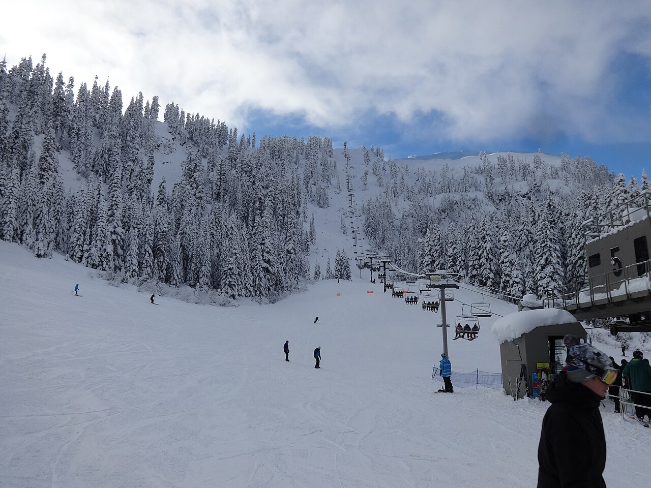
Mt Baker is a downhill ski area in Washington, United States. Mapped terrain includes beginner, easy, intermediate, advanced routes. Its mapped lift network extends from approximately 1106 to 1556 metres above sea level.
Data: OpenSkiData / OpenSkiMap, OpenStreetMap contributors (ODbL), Skimap.org, Who's On First, Mapterhorn.
Προετοιμασία γραφημάτων…
Οι ώρες και οι τιμές αντιστοιχούν στην αναλυτική πρόγνωση. Πατήστε μια τιμή για λεπτομέρειες και μετακινήστε οριζόντια τα γραφήματα για επόμενες ημέρες. Ο υετός είναι το συνολικό ισοδύναμο νερού ανά διάστημα, μαζί με το χιόνι. Η χιονόπτωση αφορά νέο χιόνι ανά διάστημα, όχι το ύψος του χιονιού στο έδαφος.
Σύγκριση GFS και ECMWF. Κάθε μοντέλο διατηρεί τις δικές του ώρες και διάρκεια πρόγνωσης. Ο υετός και το νέο χιόνι αφορούν τα διαστήματα κάθε μοντέλου, τα οποία μπορεί να διαφέρουν.
Τιμές πρόγνωσης και σημειώσεις μοντέλων
Mt Baker - Σταθμός βάσης
ECMWF · Εκτέλεση μοντέλου: Αναμενόμενη επόμενη ενημέρωση:
Ημέρα Ώρα (UTC) Θερμ. (°C) Υγρασία (%) Άνεμος (km/h) Άνεμος (κόμβοι) Άνεμος (Bft) Διεύθυνση Υετός (mm) Νέο χιόνι (cm) Πίεση (hPa) Σημείο παγοποίησης (m) Συνθήκες | Τετάρτη, 04/11 06:00 0.9 70 1 0 0B E — — 1020 2421 Clear 9% cloud 09:00 0.7 70 1 0 0B NE 0 0 1019 2579 Clear 1% cloud 12:00 0.4 73 1 1 0B E 0 0 1018 1210 Clear 0% cloud 15:00 0.4 75 1 1 1B SE 0 0 1018 1211 Partly cloudy 48% cloud 18:00 7.5 54 3 1 1B SE 0 0 1017 2638 Overcast 89% cloud 21:00 8.9 53 3 2 1B S 0 0 1015 2520 Overcast 90% cloud Πέμπτη, 05/11 00:00 5.3 71 2 1 1B S 0 0 1015 2287 Overcast 100% cloud 03:00 3.6 79 4 2 1B S 0 0 1016 2005 Overcast 98% cloud 06:00 2.2 95 4 2 1B S 2.8 0 1018 1710 Overcast 100% cloud 09:00 1.7 97 2 1 1B S 4.7 0 1019 1658 Overcast 100% cloud 12:00 0.8 97 2 1 1B SW 1.5 0.4 1021 1596 Overcast 100% cloud 15:00 1.4 97 2 1 1B S 0.78 0 1022 1545 Overcast 93% cloud 18:00 2.5 97 3 2 1B SW 0.69 0 1024 1533 Overcast 96% cloud 21:00 4 83 4 2 1B S 0.26 0 1024 1644 Overcast 90% cloud Παρασκευή, 06/11 00:00 3 85 3 1 1B S 0.06 0 1024 1662 Cloudy 58% cloud 03:00 0.3 96 2 1 1B SE 0.04 0 1024 1284 Overcast 89% cloud 06:00 1.3 94 3 2 1B SE 0.07 0 1023 1700 Overcast 93% cloud 09:00 1.4 91 4 2 1B SE 0.04 0 1022 1914 Overcast 93% cloud 12:00 2.2 85 3 2 1B SE 0 0 1021 2067 Overcast 100% cloud 15:00 1.1 95 6 3 1B SE 2.6 0.8 1022 1418 Overcast 100% cloud 18:00 1.7 92 5 3 1B SE 4.1 0 1021 2069 Overcast 100% cloud 21:00 3.6 85 4 2 1B S 2.7 0 1019 2666 Overcast 100% cloud Σάββατο, 07/11 00:00 3.3 90 3 2 1B SE 9.8 0 1018 2708 Overcast 100% cloud 03:00 3.7 92 4 2 1B S 4.0 0 1019 2659 Overcast 100% cloud 06:00 3.7 94 2 1 1B S 0.37 0 1021 2548 Overcast 100% cloud 09:00 4.1 94 2 1 1B S 0.25 0 1020 2449 Overcast 100% cloud 12:00 3.8 96 2 1 1B SE 0.09 0 1021 2372 Overcast 96% cloud 15:00 2.6 96 3 1 1B E 0 0 1019 2641 Overcast 99% cloud 18:00 5.5 86 4 2 1B E 0 0 1016 2858 Overcast 99% cloud 21:00 8.7 72 4 2 1B SE 0 0 1014 3051 Overcast 94% cloud Κυριακή, 08/11 00:00 6.6 82 4 2 1B SE 0 0 1010 3003 Overcast 90% cloud 03:00 4.9 84 6 3 1B SE 0 0 1008 2729 Overcast 95% cloud 06:00 6.5 74 9 5 2B S 0 0 1006 2592 Overcast 97% cloud 09:00 4.5 94 9 5 2B S 10.3 0 1010 2006 Overcast 100% cloud 12:00 2.9 96 9 5 2B S 6.4 0 1010 1883 Overcast 97% cloud 15:00 2.2 95 8 5 2B S 5.0 0 1014 1655 Overcast 100% cloud 18:00 2.6 95 7 4 2B S 6.2 0 1019 1572 Overcast 100% cloud 21:00 2.7 94 6 3 1B S 5.5 0 1022 1542 Overcast 98% cloud Δευτέρα, 09/11 00:00 2 96 4 2 1B S 1.5 0 1023 1494 Overcast 87% cloud 03:00 0.5 96 2 1 1B S 0 0 1024 1221 Overcast 85% cloud 06:00 0.2 95 2 1 1B E 0 0 1025 < 1206 Overcast 90% cloud 09:00 -0.8 94 3 1 1B E 0 0 1025 < 1206 Overcast 92% cloud 12:00 -2.2 93 3 2 1B NE 0 0 1023 1477 Overcast 97% cloud 15:00 -3.6 93 3 2 1B E 0 0 1021 1410 Overcast 100% cloud 18:00 3.1 75 2 1 1B SE 0 0 1020 2124 Overcast 99% cloud 21:00 5.8 52 3 2 1B SE 0 0 1019 2074 Overcast 97% cloud Τρίτη, 10/11 00:00 3.7 62 3 2 1B S 0.02 0 1019 1998 Overcast 83% cloud 03:00 3.3 69 3 2 1B SE 0.04 0 1018 2113 Overcast 99% cloud 06:00 3.7 71 5 3 1B SE 0.07 0 1017 2263 Overcast 100% cloud |
|---|
Forecast notes
Forecast table times: UTC.
Coordinates: 48.8574276°N, -121.6615746°E · Requested elevation: 1117 m. Model terrain: 1203 m. Terrain and 1000/925/850/700 hPa profiles are used for height estimates.
Outside the available profile, temperature uses an estimated 5.5°C/km height correction; wind retains the nearest available model-level value. Humidity is estimated with adjusted pressure and temperature.
These are altitude estimates, not a simulation of local mountain terrain. Precipitation, cloud and sea-level pressure use horizontal interpolation only.
Precipitation includes rain and snow water equivalent: preceding 3 hours through day 6, then 6 hours (see cell tooltip). Snow (cm) estimates fresh snowfall from precipitation and temperature using the GFS conversion; it is not snow depth on the ground. Freezing (m) uses additional 600/500 hPa temperatures when available and estimates the lowest resolved 0°C crossing above sea level. When all sampled levels are warm, the upper profile limit is shown (see tooltip). < marks an entirely cold sampled profile and its lower height limit. No extrapolation is used.
Προετοιμασία γραφημάτων…
Οι ώρες και οι τιμές αντιστοιχούν στην αναλυτική πρόγνωση. Πατήστε μια τιμή για λεπτομέρειες και μετακινήστε οριζόντια τα γραφήματα για επόμενες ημέρες. Ο υετός είναι το συνολικό ισοδύναμο νερού ανά διάστημα, μαζί με το χιόνι. Η χιονόπτωση αφορά νέο χιόνι ανά διάστημα, όχι το ύψος του χιονιού στο έδαφος.
Σύγκριση GFS και ECMWF. Κάθε μοντέλο διατηρεί τις δικές του ώρες και διάρκεια πρόγνωσης. Ο υετός και το νέο χιόνι αφορούν τα διαστήματα κάθε μοντέλου, τα οποία μπορεί να διαφέρουν.
Τιμές πρόγνωσης και σημειώσεις μοντέλων
Mt Baker - Άνω σταθμός
ECMWF · Εκτέλεση μοντέλου: Αναμενόμενη επόμενη ενημέρωση:
Ημέρα Ώρα (UTC) Θερμ. (°C) Υγρασία (%) Άνεμος (km/h) Άνεμος (κόμβοι) Άνεμος (Bft) Διεύθυνση Υετός (mm) Νέο χιόνι (cm) Πίεση (hPa) Σημείο παγοποίησης (m) Συνθήκες | Τετάρτη, 04/11 06:00 4.1 51 6 3 1B S — — 1020 2422 Clear 8% cloud 09:00 4.2 55 5 3 1B S 0 0 1019 2582 Clear 1% cloud 12:00 4.4 57 4 2 1B SW 0 0 1018 1205 Clear 0% cloud 15:00 4.3 59 7 4 2B S 0 0 1018 1205 Partly cloudy 48% cloud 18:00 4.6 60 7 4 2B S 0 0 1017 2639 Overcast 89% cloud 21:00 5.4 60 9 5 2B S 0 0 1015 2519 Overcast 90% cloud Πέμπτη, 05/11 00:00 4.5 63 13 7 3B S 0 0 1015 2286 Overcast 100% cloud 03:00 2.8 78 18 10 3B S 0 0 1016 2002 Overcast 99% cloud 06:00 0.7 99 17 9 3B S 2.9 0.9 1018 1709 Overcast 100% cloud 09:00 0.6 98 17 9 3B SW 4.8 1.9 1019 1658 Overcast 100% cloud 12:00 0.2 98 19 10 3B SW 1.6 0.5 1021 1596 Overcast 100% cloud 15:00 -0.1 98 13 7 3B SW 0.81 0.2 1022 1545 Overcast 94% cloud 18:00 -0.1 99 15 8 3B SW 0.73 0.2 1024 1533 Overcast 96% cloud 21:00 0.4 88 11 6 2B SW 0.26 0.1 1024 1641 Overcast 89% cloud Παρασκευή, 06/11 00:00 0.6 88 13 7 3B S 0.06 0 1024 1661 Cloudy 59% cloud 03:00 0.5 95 14 8 3B S 0.05 0 1024 1258 Overcast 90% cloud 06:00 0.6 96 16 8 3B S 0.07 0 1023 1699 Overcast 93% cloud 09:00 1.2 82 16 9 3B S 0.05 0 1022 1915 Overcast 93% cloud 12:00 2 68 18 10 3B S 0 0 1021 2069 Overcast 100% cloud 15:00 -0.4 93 22 12 4B S 2.6 0.8 1022 1413 Overcast 100% cloud 18:00 0.8 88 23 12 4B S 4.1 1.7 1021 2063 Overcast 100% cloud 21:00 2.6 84 25 14 4B S 2.7 0 1019 2663 Overcast 100% cloud Σάββατο, 07/11 00:00 3.5 90 25 13 4B S 9.9 0 1018 2706 Overcast 100% cloud 03:00 4 93 23 13 4B SW 4.0 0 1020 2657 Overcast 100% cloud 06:00 4.2 97 18 10 3B SW 0.39 0 1021 2547 Overcast 100% cloud 09:00 4 97 16 9 3B SW 0.25 0 1020 2447 Overcast 100% cloud 12:00 3.4 92 12 7 3B S 0.10 0 1021 2374 Overcast 96% cloud 15:00 4.5 67 10 6 2B SE 0 0 1019 2647 Overcast 99% cloud 18:00 6.9 51 16 9 3B S 0 0 1016 2863 Overcast 99% cloud 21:00 8.2 59 18 10 3B S 0 0 1014 3051 Overcast 94% cloud Κυριακή, 08/11 00:00 8.7 64 24 13 4B S 0 0 1010 3002 Overcast 90% cloud 03:00 8.3 62 31 17 5B S 0 0 1008 2728 Overcast 95% cloud 06:00 7.6 59 43 23 6B S 0 0 1006 2590 Overcast 97% cloud 09:00 2.7 95 42 23 6B SW 10.5 0 1010 2005 Overcast 100% cloud 12:00 2.1 97 39 21 5B SW 6.5 0 1011 1883 Overcast 97% cloud 15:00 0.6 99 36 19 5B SW 5.2 2.1 1014 1654 Overcast 100% cloud 18:00 0.1 99 32 17 5B SW 6.4 2.6 1019 1571 Overcast 100% cloud 21:00 -0.1 98 24 13 4B SW 5.7 2.3 1022 1541 Overcast 98% cloud Δευτέρα, 09/11 00:00 -0.4 93 18 10 3B SW 1.6 0.5 1023 1489 Overcast 88% cloud 03:00 -0.9 92 16 9 3B SW 0 0 1024 1215 Overcast 86% cloud 06:00 -1.1 91 5 3 1B SW 0 0 1025 < 1204 Overcast 90% cloud 09:00 -1.1 83 8 5 2B SE 0 0 1025 < 1204 Overcast 93% cloud 12:00 0.2 63 6 3 2B SE 0 0 1023 1472 Overcast 97% cloud 15:00 1.6 45 11 6 2B SE 0 0 1021 1408 Overcast 100% cloud 18:00 2.5 38 12 6 2B S 0 0 1020 2128 Overcast 99% cloud 21:00 3 41 15 8 3B S 0 0 1019 2073 Overcast 97% cloud Τρίτη, 10/11 00:00 2.7 51 20 11 4B S 0.02 0 1019 1997 Overcast 84% cloud 03:00 2.7 64 17 9 3B S 0.05 0 1018 2116 Overcast 99% cloud 06:00 3.2 64 26 14 4B S 0.06 0 1017 2264 Overcast 100% cloud |
|---|
Forecast notes
Forecast table times: UTC.
Coordinates: 48.8482821°N, -121.6652069°E · Requested elevation: 1556 m. Model terrain: 1201 m. Terrain and 1000/925/850/700 hPa profiles are used for height estimates.
These are altitude estimates, not a simulation of local mountain terrain. Precipitation, cloud and sea-level pressure use horizontal interpolation only.
Precipitation includes rain and snow water equivalent: preceding 3 hours through day 6, then 6 hours (see cell tooltip). Snow (cm) estimates fresh snowfall from precipitation and temperature using the GFS conversion; it is not snow depth on the ground. Freezing (m) uses additional 600/500 hPa temperatures when available and estimates the lowest resolved 0°C crossing above sea level. When all sampled levels are warm, the upper profile limit is shown (see tooltip). < marks an entirely cold sampled profile and its lower height limit. No extrapolation is used.