世界のスキー場の天気予報

色の凡例 気温 · 風 · 雨 · 雪
各色は表示された値から始まります。風の色は3種類の単位で対応しています。降水のないセルは中立色です。色は表示値を示すもので、公的な気象警報ではありません。
予報グラフを準備中…
時刻と値は詳細予報と一致します。値をタップするかカーソルを合わせると詳細が表示されます。先の日付を見るには各グラフを横にスクロールしてください。雨・降水量は雪を含む各予報時間帯の水換算量です。降雪量は各時間帯の新雪量であり、積雪深ではありません。
GFSとECMWFのモデル比較です。各モデル固有の予報時刻と予報期間を維持しています。降水量と降雪量はそれぞれの予報時間帯の合計であり、時間帯はモデル間で異なる場合があります。
予報値とモデルに関する注記
Mountain High - Low lift station
ECMWF · モデル計算時刻: 次回更新予定:
日 時刻(UTC) 気温(°C) 湿度(%) 風速(km/h) 風速(ノット) 風(ビューフォート) 風向 降水量(mm) 降雪量(cm) 気圧(hPa) 0°C高度(m) 天気 | 水曜日, 04/11 06:00 10 34 23 12 4B W — — 1015 3098 Clear 7% cloud  09:00 9.3 37 27 14 4B W 0 0 1015 3090 Clear 8% cloud 12:00 9.2 43 26 14 4B W 0 0 1014 3082 Clear 7% cloud 15:00 8.9 43 21 12 4B NW 0 0 1015 3088 Clear 1% cloud 18:00 9.2 44 12 6 2B NW 0 0 1015 3096 Clear 0% cloud 21:00 10.5 44 8 4 2B N 0 0 1014 3093 Clear 1% cloud 木曜日, 05/11 00:00 11 41 7 4 2B N 0 0 1013 3093 Clear 0% cloud 03:00 10.5 37 7 4 2B NE 0 0 1015 3100 Clear 0% cloud 06:00 10.3 33 7 4 2B NE 0 0 1015 3106 Clear 0% cloud 09:00 10.2 29 7 4 2B NE 0 0 1016 3106 Partly cloudy 25% cloud  12:00 9.9 28 5 3 1B N 0 0 1015 3100 Partly cloudy 35% cloud 15:00 9.7 30 7 4 2B N 0 0 1016 3108 Clear 7% cloud 18:00 10.2 32 7 4 2B N 0 0 1017 3117 Clear 10% cloud 21:00 11.2 32 9 5 2B NW 0 0 1015 3108 Partly cloudy 38% cloud 金曜日, 06/11 00:00 10.9 34 15 8 3B NW 0 0 1015 3112 Clear 0% cloud 03:00 10.2 32 17 9 3B N 0 0 1017 3117 Clear 0% cloud 06:00 10 32 17 9 3B NE 0 0 1018 3128 Clear 0% cloud 09:00 10.1 29 16 9 3B NE 0 0 1019 3131 Clear 0% cloud 12:00 9.8 30 19 10 3B N 0 0 1018 3124 Clear 0% cloud 15:00 9.5 32 21 11 4B N 0 0 1020 3137 Clear 0% cloud 18:00 9.6 31 27 15 4B NE 0 0 1020 3142 Clear 0% cloud 21:00 10.5 24 27 14 4B NE 0 0 1018 3129 Clear 0% cloud 土曜日, 07/11 00:00 10.9 20 30 16 5B NE 0 0 1017 3129 Clear 0% cloud 03:00 10.3 25 33 18 5B NE 0 0 1019 3136 Clear 0% cloud 06:00 10.3 28 36 19 5B NE 0 0 1020 3142 Clear 4% cloud 09:00 10.4 30 32 17 5B NE 0 0 1019 3139 Clear 17% cloud 12:00 10.7 30 29 15 4B NE 0 0 1019 3140 Clear 0% cloud 15:00 11.4 27 25 14 4B NE 0 0 1020 3153 Clear 0% cloud 18:00 12 26 22 12 4B NE 0 0 1020 3162 Clear 0% cloud 21:00 13 25 15 8 3B NE 0 0 1018 3154 Clear 0% cloud 日曜日, 08/11 00:00 13.1 24 14 7 3B NE 0 0 1018 3156 Clear 0% cloud 03:00 12.8 24 15 8 3B NE 0 0 1019 3163 Clear 0% cloud 06:00 13 23 13 7 3B NE 0 0 1020 3169 Clear 0% cloud 09:00 12.8 23 9 5 2B NE 0 0 1019 3164 Clear 0% cloud 12:00 12.5 23 8 4 2B NE 0 0 1019 3157 Clear 0% cloud 15:00 12.4 23 10 5 2B NE 0 0 1020 3169 Clear 0% cloud 18:00 13.1 24 12 6 2B E 0 0 1021 3176 Clear 0% cloud 21:00 13.8 26 9 5 2B E 0 0 1019 3162 Clear 0% cloud 月曜日, 09/11 00:00 14 27 8 4 2B NE 0 0 1018 3159 Clear 0% cloud 03:00 13.5 28 6 3 2B NE 0 0 1019 3163 Clear 0% cloud 06:00 13.4 30 7 4 2B E 0 0 1020 3170 Clear 0% cloud 09:00 13.2 30 6 3 2B E 0 0 1019 3161 Clear 0% cloud 12:00 12.8 30 4 2 1B E 0 0 1018 3152 Clear 0% cloud 15:00 12.4 29 2 1 1B E 0 0 1019 3158 Clear 0% cloud 18:00 12.8 29 2 1 1B E 0 0 1020 3167 Clear 0% cloud 21:00 13.5 29 3 2 1B NE 0 0 1018 3156 Cloudy 62% cloud  火曜日, 10/11 00:00 13.6 30 4 2 1B N 0 0 1018 3156 Overcast 92% cloud  03:00 13.2 30 2 1 1B NE 0 0 1019 3162 Partly cloudy 31% cloud 06:00 13.1 29 1 1 1B NW 0 0 1020 3167 Clear 12% cloud |
|---|
Forecast notes
Forecast table times: UTC.
Coordinates: 34.3718312°N, -117.6766156°E · Requested elevation: 2006 m. Model terrain: 1231 m. Terrain and 1000/925/850/700 hPa profiles are used for height estimates.
These are altitude estimates, not a simulation of local mountain terrain. Precipitation, cloud and sea-level pressure use horizontal interpolation only.
Precipitation includes rain and snow water equivalent: preceding 3 hours through day 6, then 6 hours (see cell tooltip). Snow (cm) estimates fresh snowfall from precipitation and temperature using the GFS conversion; it is not snow depth on the ground. Freezing (m) uses additional 600/500 hPa temperatures when available and estimates the lowest resolved 0°C crossing above sea level. When all sampled levels are warm, the upper profile limit is shown (see tooltip). < marks an entirely cold sampled profile and its lower height limit. No extrapolation is used.
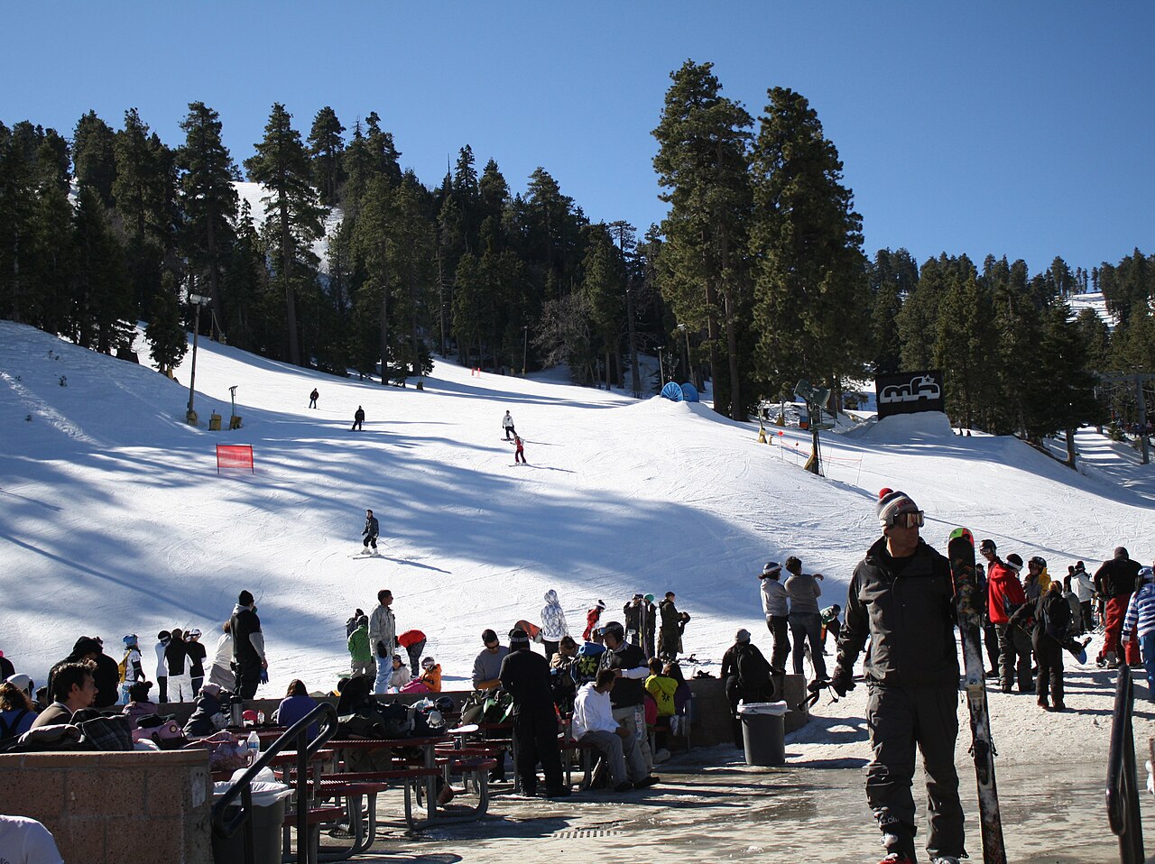
Mountain High is a downhill ski area in California, United States. Mapped terrain includes beginner, easy, intermediate, advanced, expert routes. Its mapped lift network extends from approximately 2006 to 2494 metres above sea level.
Data: OpenSkiData / OpenSkiMap, OpenStreetMap contributors (ODbL), Skimap.org, Who's On First, Mapterhorn.
予報グラフを準備中…
時刻と値は詳細予報と一致します。値をタップするかカーソルを合わせると詳細が表示されます。先の日付を見るには各グラフを横にスクロールしてください。雨・降水量は雪を含む各予報時間帯の水換算量です。降雪量は各時間帯の新雪量であり、積雪深ではありません。
GFSとECMWFのモデル比較です。各モデル固有の予報時刻と予報期間を維持しています。降水量と降雪量はそれぞれの予報時間帯の合計であり、時間帯はモデル間で異なる場合があります。
予報値とモデルに関する注記
Mountain High - Base lift station
ECMWF · モデル計算時刻: 次回更新予定:
日 時刻(UTC) 気温(°C) 湿度(%) 風速(km/h) 風速(ノット) 風(ビューフォート) 風向 降水量(mm) 降雪量(cm) 気圧(hPa) 0°C高度(m) 天気 | 水曜日, 04/11 06:00 9.7 31 25 13 4B W — — 1015 3098 Clear 5% cloud 09:00 9.1 35 29 16 5B W 0 0 1015 3090 Clear 6% cloud 12:00 9.1 40 29 16 5B NW 0 0 1014 3082 Clear 6% cloud 15:00 8.8 39 24 13 4B NW 0 0 1015 3088 Clear 1% cloud 18:00 9 41 14 7 3B NW 0 0 1015 3096 Clear 0% cloud 21:00 10.2 42 9 5 2B N 0 0 1014 3093 Clear 1% cloud 木曜日, 05/11 00:00 10.6 39 7 4 2B N 0 0 1013 3093 Clear 0% cloud 03:00 10.1 36 6 3 2B N 0 0 1015 3100 Clear 0% cloud 06:00 9.9 32 7 4 2B NE 0 0 1015 3106 Clear 0% cloud 09:00 9.7 28 6 3 2B NE 0 0 1016 3106 Partly cloudy 27% cloud 12:00 9.5 27 5 3 1B N 0 0 1015 3100 Partly cloudy 34% cloud 15:00 9.2 29 6 3 2B N 0 0 1016 3108 Clear 6% cloud 18:00 9.7 31 7 4 2B N 0 0 1017 3117 Clear 10% cloud 21:00 10.7 31 11 6 2B NW 0 0 1015 3108 Partly cloudy 37% cloud 金曜日, 06/11 00:00 10.3 33 17 9 3B NW 0 0 1015 3113 Clear 0% cloud 03:00 9.6 31 19 10 3B N 0 0 1017 3117 Clear 0% cloud 06:00 9.4 31 18 10 3B NE 0 0 1018 3128 Clear 0% cloud 09:00 9.6 28 17 9 3B N 0 0 1019 3131 Clear 0% cloud 12:00 9.3 29 20 11 4B N 0 0 1018 3125 Clear 0% cloud 15:00 9 31 22 12 4B N 0 0 1020 3137 Clear 0% cloud 18:00 9.1 29 29 15 4B N 0 0 1020 3142 Clear 0% cloud 21:00 9.9 23 29 15 4B NE 0 0 1018 3129 Clear 0% cloud 土曜日, 07/11 00:00 10.3 20 32 17 5B NE 0 0 1017 3129 Clear 0% cloud 03:00 9.8 24 35 19 5B NE 0 0 1019 3136 Clear 0% cloud 06:00 9.9 27 38 20 5B NE 0 0 1020 3142 Clear 4% cloud 09:00 10 29 33 18 5B NE 0 0 1019 3139 Clear 17% cloud 12:00 10.3 28 30 16 5B NE 0 0 1019 3140 Clear 0% cloud 15:00 11 26 26 14 4B NE 0 0 1020 3153 Clear 0% cloud 18:00 11.6 25 22 12 4B NE 0 0 1020 3162 Clear 0% cloud 21:00 12.5 24 15 8 3B NE 0 0 1018 3154 Clear 0% cloud 日曜日, 08/11 00:00 12.6 23 14 8 3B NE 0 0 1018 3156 Clear 0% cloud 03:00 12.4 22 15 8 3B NE 0 0 1019 3163 Clear 0% cloud 06:00 12.5 22 13 7 3B NE 0 0 1020 3169 Clear 0% cloud 09:00 12.3 22 10 5 2B E 0 0 1019 3164 Clear 0% cloud 12:00 12.1 22 8 4 2B NE 0 0 1019 3157 Clear 0% cloud 15:00 12 22 10 5 2B NE 0 0 1020 3169 Clear 0% cloud 18:00 12.7 23 12 6 2B E 0 0 1021 3176 Clear 0% cloud 21:00 13.3 25 9 5 2B E 0 0 1019 3162 Clear 0% cloud 月曜日, 09/11 00:00 13.4 26 8 4 2B NE 0 0 1018 3159 Clear 0% cloud 03:00 13 27 6 3 2B E 0 0 1019 3163 Clear 0% cloud 06:00 12.9 29 8 4 2B E 0 0 1020 3170 Clear 0% cloud 09:00 12.7 29 6 3 2B E 0 0 1019 3161 Clear 0% cloud 12:00 12.3 30 4 2 1B E 0 0 1018 3152 Clear 0% cloud 15:00 11.9 28 3 1 1B E 0 0 1019 3158 Clear 0% cloud 18:00 12.3 28 2 1 1B E 0 0 1020 3167 Clear 0% cloud 21:00 12.9 28 3 2 1B NE 0 0 1018 3157 Cloudy 62% cloud 火曜日, 10/11 00:00 13 29 4 2 1B N 0 0 1018 3156 Overcast 91% cloud 03:00 12.6 29 2 1 1B NE 0 0 1019 3162 Partly cloudy 31% cloud 06:00 12.5 28 1 0 0B NW 0 0 1020 3167 Clear 12% cloud |
|---|
Forecast notes
Forecast table times: UTC.
Coordinates: 34.3764346°N, -117.691154°E · Requested elevation: 2105 m. Model terrain: 1231 m. Terrain and 1000/925/850/700 hPa profiles are used for height estimates.
These are altitude estimates, not a simulation of local mountain terrain. Precipitation, cloud and sea-level pressure use horizontal interpolation only.
Precipitation includes rain and snow water equivalent: preceding 3 hours through day 6, then 6 hours (see cell tooltip). Snow (cm) estimates fresh snowfall from precipitation and temperature using the GFS conversion; it is not snow depth on the ground. Freezing (m) uses additional 600/500 hPa temperatures when available and estimates the lowest resolved 0°C crossing above sea level. When all sampled levels are warm, the upper profile limit is shown (see tooltip). < marks an entirely cold sampled profile and its lower height limit. No extrapolation is used.
予報グラフを準備中…
時刻と値は詳細予報と一致します。値をタップするかカーソルを合わせると詳細が表示されます。先の日付を見るには各グラフを横にスクロールしてください。雨・降水量は雪を含む各予報時間帯の水換算量です。降雪量は各時間帯の新雪量であり、積雪深ではありません。
GFSとECMWFのモデル比較です。各モデル固有の予報時刻と予報期間を維持しています。降水量と降雪量はそれぞれの予報時間帯の合計であり、時間帯はモデル間で異なる場合があります。
予報値とモデルに関する注記
Mountain High - Top lift station
ECMWF · モデル計算時刻: 次回更新予定:
日 時刻(UTC) 気温(°C) 湿度(%) 風速(km/h) 風速(ノット) 風(ビューフォート) 風向 降水量(mm) 降雪量(cm) 気圧(hPa) 0°C高度(m) 天気 | 水曜日, 04/11 06:00 8.6 23 33 18 5B W — — 1015 3098 Clear 7% cloud 09:00 8.3 27 39 21 5B W 0 0 1015 3090 Clear 8% cloud 12:00 8.7 29 41 22 6B NW 0 0 1014 3083 Clear 7% cloud 15:00 8.4 27 35 19 5B NW 0 0 1015 3088 Clear 1% cloud 18:00 8.2 30 23 12 4B NW 0 0 1015 3096 Clear 0% cloud 21:00 8.9 31 14 7 3B NW 0 0 1014 3093 Clear 1% cloud 木曜日, 05/11 00:00 9.1 31 10 5 2B NW 0 0 1013 3093 Clear 0% cloud 03:00 8.7 30 7 4 2B NW 0 0 1015 3100 Clear 0% cloud 06:00 8.3 27 7 4 2B N 0 0 1015 3106 Clear 0% cloud 09:00 8.1 25 5 3 1B N 0 0 1016 3106 Partly cloudy 25% cloud 12:00 7.8 24 6 3 2B NW 0 0 1015 3100 Partly cloudy 35% cloud 15:00 7.5 26 8 5 2B NW 0 0 1016 3108 Clear 6% cloud 18:00 7.9 28 11 6 2B NW 0 0 1017 3117 Clear 10% cloud 21:00 8.6 28 16 9 3B NW 0 0 1015 3108 Partly cloudy 40% cloud 金曜日, 06/11 00:00 8.1 28 23 13 4B NW 0 0 1015 3113 Clear 0% cloud 03:00 7.3 26 27 15 4B N 0 0 1017 3117 Clear 0% cloud 06:00 7.2 28 25 13 4B NE 0 0 1018 3128 Clear 0% cloud 09:00 7.4 24 22 12 4B N 0 0 1018 3131 Clear 0% cloud 12:00 7.3 23 27 15 4B N 0 0 1018 3125 Clear 0% cloud 15:00 7.2 25 31 17 5B N 0 0 1020 3137 Clear 0% cloud 18:00 7.4 23 37 20 5B N 0 0 1020 3142 Clear 0% cloud 21:00 7.7 18 39 21 5B N 0 0 1018 3129 Clear 0% cloud 土曜日, 07/11 00:00 7.9 16 43 23 6B NE 0 0 1017 3128 Clear 0% cloud 03:00 7.9 19 46 25 6B NE 0 0 1019 3136 Clear 0% cloud 06:00 8 21 46 25 6B NE 0 0 1020 3141 Clear 4% cloud 09:00 8.2 23 41 22 6B NE 0 0 1019 3139 Clear 19% cloud 12:00 8.7 22 36 20 5B NE 0 0 1019 3140 Clear 0% cloud 15:00 9.4 20 31 17 5B NE 0 0 1020 3153 Clear 0% cloud 18:00 10 19 25 14 4B NE 0 0 1020 3162 Clear 0% cloud 21:00 10.5 19 18 10 3B NE 0 0 1018 3154 Clear 0% cloud 日曜日, 08/11 00:00 10.7 19 16 9 3B NE 0 0 1018 3156 Clear 0% cloud 03:00 10.6 18 18 10 3B NE 0 0 1019 3163 Clear 0% cloud 06:00 10.8 17 15 8 3B NE 0 0 1020 3169 Clear 0% cloud 09:00 10.5 18 12 6 2B NE 0 0 1019 3164 Clear 0% cloud 12:00 10.4 18 9 5 2B NE 0 0 1019 3157 Clear 0% cloud 15:00 10.2 18 11 6 2B NE 0 0 1020 3169 Clear 0% cloud 18:00 10.8 18 13 7 3B NE 0 0 1021 3176 Clear 0% cloud 21:00 11.1 21 11 6 2B E 0 0 1019 3162 Clear 0% cloud 月曜日, 09/11 00:00 11.2 23 9 5 2B E 0 0 1018 3159 Clear 0% cloud 03:00 11 23 7 4 2B E 0 0 1019 3163 Clear 0% cloud 06:00 10.9 25 7 4 2B E 0 0 1020 3170 Clear 0% cloud 09:00 10.8 26 4 2 1B E 0 0 1019 3161 Clear 0% cloud 12:00 10.5 25 4 2 1B E 0 0 1018 3152 Clear 0% cloud 15:00 10 24 3 2 1B E 0 0 1019 3158 Clear 0% cloud 18:00 10.2 25 3 2 1B E 0 0 1020 3167 Clear 0% cloud 21:00 10.5 26 3 2 1B NE 0 0 1018 3156 Cloudy 64% cloud 火曜日, 10/11 00:00 10.6 26 4 2 1B N 0 0 1018 3156 Overcast 91% cloud 03:00 10.3 25 3 2 1B NE 0 0 1019 3162 Partly cloudy 31% cloud 06:00 10.2 26 1 1 0B N 0 0 1020 3167 Clear 12% cloud |
|---|
Forecast notes
Forecast table times: UTC.
Coordinates: 34.3579083°N, -117.6823445°E · Requested elevation: 2494 m. Model terrain: 1252 m. Terrain and 1000/925/850/700 hPa profiles are used for height estimates.
These are altitude estimates, not a simulation of local mountain terrain. Precipitation, cloud and sea-level pressure use horizontal interpolation only.
Precipitation includes rain and snow water equivalent: preceding 3 hours through day 6, then 6 hours (see cell tooltip). Snow (cm) estimates fresh snowfall from precipitation and temperature using the GFS conversion; it is not snow depth on the ground. Freezing (m) uses additional 600/500 hPa temperatures when available and estimates the lowest resolved 0°C crossing above sea level. When all sampled levels are warm, the upper profile limit is shown (see tooltip). < marks an entirely cold sampled profile and its lower height limit. No extrapolation is used.