Faloria · Cortina · Panorama

Provider panorama/video player. Capture time is shown by the camera.
Open camera page ↗
Chaque couleur commence à la valeur indiquée. Les couleurs du vent correspondent dans les trois unités. Les cases sans précipitations restent neutres. Les couleurs décrivent les valeurs affichées et ne sont pas des alertes officielles.
Préparation des graphiques…
Les heures et valeurs correspondent aux prévisions détaillées. Touchez une valeur pour plus de détails et faites défiler horizontalement pour les jours suivants. Les précipitations représentent l’équivalent en eau total par intervalle, neige comprise. La neige fraîche correspond à chaque intervalle, et non à l’épaisseur au sol.
Comparaison GFS et ECMWF. Chaque modèle conserve ses heures et son horizon de prévision. Les quantités de précipitations et de neige couvrent leurs propres intervalles, qui peuvent différer entre modèles.
ECMWF · Cycle du modèle : Prochaine mise à jour attendue :
Jour Heure (UTC) Temp. (°C) Humidité (%) Vent (km/h) Vent (nœuds) Vent (Bft) Direction Précip. (mm) Neige fraîche (cm) Pression (hPa) Isotherme 0 °C (m) Conditions | Mercredi, 04/11 06:00 2.7 80 3 2 1B NE — — 1025 < 1800 Overcast 87% cloud  09:00 4.9 67 3 2 1B SE 0.01 0 1026 2051 Overcast 99% cloud 12:00 5.9 64 4 2 1B SE 0 0 1026 2152 Overcast 96% cloud 15:00 5.7 64 3 1 1B SE 0.02 0 1025 2191 Cloudy 63% cloud  18:00 3.5 74 0 0 0B E 0.00 0 1027 1897 Cloudy 66% cloud 21:00 2.4 78 1 0 0B NE 0 0 1029 < 1800 Partly cloudy 50% cloud  Jeudi, 05/11 00:00 0.6 81 1 1 1B N 0 0 1029 < 1800 Partly cloudy 48% cloud 03:00 0.2 78 3 1 1B N 0 0 1028 < 1800 Partly cloudy 49% cloud 06:00 0.8 74 2 1 1B NW 0 0 1028 < 1800 Partly cloudy 43% cloud 09:00 6.8 56 2 1 1B SE 0 0 1028 2645 Clear 1% cloud  12:00 10 44 5 2 1B S 0 0 1025 2830 Clear 0% cloud 15:00 7.8 59 2 1 1B S 0 0 1024 2910 Clear 0% cloud 18:00 3.3 69 1 1 1B NW 0 0 1026 2103 Clear 0% cloud 21:00 2.3 67 1 1 1B NW 0 0 1025 < 1800 Clear 0% cloud Vendredi, 06/11 00:00 2.4 64 1 1 1B NW 0 0 1024 < 1800 Clear 0% cloud 03:00 2.7 60 1 1 1B NW 0 0 1023 < 1800 Clear 0% cloud 06:00 3 58 1 0 0B NW 0 0 1022 < 1800 Clear 0% cloud 09:00 9.2 44 2 1 1B SE 0 0 1022 3000 Clear 0% cloud 12:00 11.1 43 5 3 1B SE 0 0 1020 2967 Clear 1% cloud 15:00 8.1 61 3 2 1B S 0 0 1020 2814 Clear 19% cloud 18:00 3.5 75 1 0 0B NE 0 0 1021 2016 Partly cloudy 40% cloud 21:00 3.4 79 1 1 0B NE 0 0 1023 1908 Overcast 100% cloud Samedi, 07/11 00:00 3.4 77 1 1 1B NE 0.05 0 1022 1880 Overcast 99% cloud 03:00 3.1 71 1 1 1B NE 0 0 1022 < 1800 Cloudy 55% cloud 06:00 2.6 70 1 0 0B NE 0 0 1023 < 1800 Cloudy 59% cloud 09:00 5.3 53 3 2 1B E 0.14 0 1024 2128 Overcast 100% cloud 12:00 5.5 53 3 2 1B SE 0.61 0 1024 2131 Overcast 99% cloud 15:00 4.7 54 3 2 1B SE 0.05 0 1024 2056 Overcast 100% cloud 18:00 3 66 1 1 1B E 0.20 0 1025 < 1800 Overcast 99% cloud 21:00 2.9 68 1 1 0B NE 0.19 0 1026 < 1800 Overcast 96% cloud Dimanche, 08/11 00:00 1.8 71 1 0 0B N 0.01 0 1026 < 1800 Cloudy 77% cloud 03:00 1.2 74 0 0 0B SW 0.12 0 1025 < 1800 Overcast 97% cloud 06:00 1.3 73 1 0 0B NW 0.49 0 1026 < 1800 Overcast 87% cloud 09:00 3.9 64 3 2 1B S 0.01 0 1026 1900 Overcast 81% cloud 12:00 5.5 58 4 2 1B S 0 0 1024 2093 Overcast 97% cloud 15:00 4.8 62 3 2 1B S 0.05 0 1024 2030 Overcast 90% cloud 18:00 1.9 74 0 0 0B W 0 0 1025 < 1800 Partly cloudy 41% cloud 21:00 0.2 76 1 1 1B NW 0 0 1026 < 1800 Partly cloudy 39% cloud Lundi, 09/11 00:00 -0.7 77 2 1 1B NW 0 0 1025 < 1800 Partly cloudy 47% cloud 03:00 0.1 67 1 1 1B NW 0 0 1025 < 1800 Overcast 83% cloud 06:00 1.2 61 1 0 0B W 0 0 1025 < 1800 Cloudy 66% cloud 09:00 5.3 54 3 1 1B S 0 0 1024 2460 Partly cloudy 48% cloud 12:00 7.2 54 5 3 1B S 0 0 1022 2690 Partly cloudy 46% cloud 15:00 5.1 68 4 2 1B S 0 0 1022 2476 Overcast 81% cloud 18:00 2.2 80 1 1 1B W 0 0 1023 < 1800 Overcast 95% cloud 21:00 3.3 80 1 1 1B SW 0 0 1022 1866 Overcast 100% cloud Mardi, 10/11 00:00 4.1 80 1 1 1B W 0.02 0 1021 2290 Overcast 100% cloud 03:00 4.3 80 2 1 1B NW 0 0 1019 2541 Overcast 100% cloud 06:00 4.6 79 1 1 0B W 0 0 1018 2631 Overcast 99% cloud |
|---|
Forecast table times: UTC.
Coordinates: 46.537995°N, 12.1406781°E · Requested elevation: 1225 m. Model terrain: 1797 m. Terrain and 1000/925/850/700 hPa profiles are used for height estimates.
Outside the available profile, temperature uses an estimated 5.5°C/km height correction; wind retains the nearest available model-level value. Humidity is estimated with adjusted pressure and temperature.
These are altitude estimates, not a simulation of local mountain terrain. Precipitation, cloud and sea-level pressure use horizontal interpolation only.
Precipitation includes rain and snow water equivalent: preceding 3 hours through day 6, then 6 hours (see cell tooltip). Snow (cm) estimates fresh snowfall from precipitation and temperature using the GFS conversion; it is not snow depth on the ground. Freezing (m) uses additional 600/500 hPa temperatures when available and estimates the lowest resolved 0°C crossing above sea level. When all sampled levels are warm, the upper profile limit is shown (see tooltip). < marks an entirely cold sampled profile and its lower height limit. No extrapolation is used.
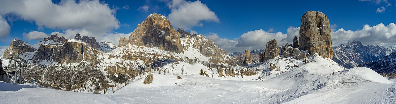
Cortina d’Ampezzo réunit plusieurs secteurs autour de la vallée d’Ampezzo, plutôt qu’une montagne compacte desservie par un seul départ. Faloria–Cristallo, Tofana et 5 Torri–Lagazuoi offrent des points de départ différents. La télécabine Cortina Skyline relie Son dei Prade à Bai de Dones ; un plan actuel reste donc utile même si vous connaissez déjà la station.
Cette page distingue trois lieux de prévision : le départ du téléphérique Faloria à 1 225 m, la station supérieure de Faloria à 2 123 m et Ra Valles, dans le secteur Tofana, à 2 470 m. Ce sont des points réels situés à différents endroits, pas trois altitudes au-dessus d’une seule coordonnée. Choisissez celui qui correspond le mieux à votre programme avant de comparer température et neige.
Si une webcam montre de la neige alors que la prévision basse annonce de la pluie, vérifiez d’abord sa position et son altitude. Pour une journée entre plusieurs secteurs, comparez les horaires des conditions à destination et au retour. Les informations de l’exploitant restent la référence pour l’accès réel : ni un forfait commun ni une météo favorable ne confirment l’ouverture de toutes les liaisons.
Sources officielles: Cortina — skiing and snowboarding · Faloria · Tofana official map. Informations vérifiées le 18 octobre 2026.
Provider panorama/video player. Capture time is shown by the camera.
Open camera page ↗Préparation des graphiques…
Les heures et valeurs correspondent aux prévisions détaillées. Touchez une valeur pour plus de détails et faites défiler horizontalement pour les jours suivants. Les précipitations représentent l’équivalent en eau total par intervalle, neige comprise. La neige fraîche correspond à chaque intervalle, et non à l’épaisseur au sol.
Comparaison GFS et ECMWF. Chaque modèle conserve ses heures et son horizon de prévision. Les quantités de précipitations et de neige couvrent leurs propres intervalles, qui peuvent différer entre modèles.
ECMWF · Cycle du modèle : Prochaine mise à jour attendue :
Jour Heure (UTC) Temp. (°C) Humidité (%) Vent (km/h) Vent (nœuds) Vent (Bft) Direction Précip. (mm) Neige fraîche (cm) Pression (hPa) Isotherme 0 °C (m) Conditions | Mercredi, 04/11 06:00 -2.2 94 5 3 1B SE — — 1025 < 1774 Overcast 85% cloud 09:00 -0.6 82 8 4 2B SE 0.01 0 1026 2045 Overcast 99% cloud 12:00 0.2 79 7 4 2B SE 0 0 1026 2156 Overcast 96% cloud 15:00 0.5 75 6 3 2B S 0.02 0 1025 2202 Cloudy 61% cloud 18:00 -0.7 79 5 2 1B S 0.00 0 1027 1943 Cloudy 70% cloud 21:00 -1.6 82 4 2 1B S 0 0 1029 < 1774 Cloudy 56% cloud Jeudi, 05/11 00:00 -2.8 81 4 2 1B SW 0 0 1029 < 1774 Cloudy 57% cloud 03:00 -2.9 76 3 2 1B SW 0 0 1028 < 1774 Cloudy 58% cloud 06:00 -2.4 71 4 2 1B SW 0 0 1028 < 1774 Cloudy 52% cloud 09:00 2.2 58 5 3 1B S 0 0 1028 2643 Clear 0% cloud 12:00 4.7 49 6 3 2B S 0 0 1025 2832 Clear 0% cloud 15:00 3.4 60 3 2 1B S 0 0 1024 2917 Clear 0% cloud 18:00 0.1 66 2 1 1B SW 0 0 1026 2276 Clear 0% cloud 21:00 -0.7 63 2 1 1B S 0 0 1026 < 1774 Clear 0% cloud Vendredi, 06/11 00:00 -0.7 60 3 1 1B SW 0 0 1024 < 1774 Clear 0% cloud 03:00 -0.5 59 3 1 1B SW 0 0 1023 < 1774 Clear 0% cloud 06:00 -0.2 59 3 1 1B SW 0 0 1022 < 1774 Clear 0% cloud 09:00 4.4 48 5 3 1B S 0 0 1022 3001 Clear 0% cloud 12:00 5.7 48 8 4 2B S 0 0 1020 2969 Clear 0% cloud 15:00 3.4 65 6 3 2B S 0 0 1020 2819 Partly cloudy 20% cloud 18:00 -0.1 74 4 2 1B SE 0 0 1022 2087 Partly cloudy 41% cloud 21:00 -0.6 77 7 4 2B SE 0 0 1023 1865 Overcast 100% cloud Samedi, 07/11 00:00 -0.9 81 9 5 2B SE 0.03 0 1022 1844 Overcast 100% cloud 03:00 -1.1 74 9 5 2B SE 0 0 1022 1784 Cloudy 58% cloud 06:00 -1.9 77 9 5 2B SE 0 0 1023 < 1774 Cloudy 55% cloud 09:00 0 64 12 6 2B SE 0.10 0 1024 2131 Overcast 100% cloud 12:00 0 68 10 5 2B SE 0.57 0.2 1024 2130 Overcast 99% cloud 15:00 -0.3 70 7 4 2B SE 0.03 0 1024 2071 Overcast 100% cloud 18:00 -1.7 81 6 3 2B SE 0.15 0 1025 1788 Overcast 99% cloud 21:00 -1.8 82 4 2 1B S 0.17 0 1026 < 1774 Overcast 97% cloud Dimanche, 08/11 00:00 -2.8 84 4 2 1B S 0.01 0 1026 < 1774 Cloudy 72% cloud 03:00 -3.4 90 5 3 1B SW 0.15 0.1 1025 < 1774 Overcast 98% cloud 06:00 -3.5 86 5 3 1B SW 0.55 0.5 1026 < 1774 Overcast 89% cloud 09:00 -1.6 78 6 3 2B SW 0.01 0 1026 1900 Cloudy 77% cloud 12:00 -0.3 71 6 3 2B SW 0 0 1024 2091 Overcast 97% cloud 15:00 -0.7 75 6 3 1B SW 0.03 0 1024 2024 Overcast 90% cloud 18:00 -2.4 74 6 3 1B W 0 0 1025 < 1774 Partly cloudy 42% cloud 21:00 -3.3 73 6 3 2B W 0 0 1026 < 1774 Partly cloudy 40% cloud Lundi, 09/11 00:00 -3.7 74 6 3 2B W 0 0 1025 < 1774 Cloudy 55% cloud 03:00 -3 66 6 3 2B W 0 0 1025 < 1774 Overcast 84% cloud 06:00 -2.1 65 7 4 2B W 0 0 1025 < 1774 Cloudy 70% cloud 09:00 1.1 61 8 4 2B SW 0 0 1024 2461 Partly cloudy 49% cloud 12:00 2.5 62 10 5 2B SW 0 0 1022 2692 Partly cloudy 49% cloud 15:00 1 73 11 6 2B SW 0 0 1022 2480 Overcast 82% cloud 18:00 -1.1 86 11 6 2B W 0 0 1023 < 1774 Overcast 96% cloud 21:00 -0.4 91 13 7 3B W 0 0 1022 1826 Overcast 100% cloud Mardi, 10/11 00:00 0.3 91 15 8 3B W 0.02 0 1021 2304 Overcast 100% cloud 03:00 0.7 90 14 8 3B W 0 0 1019 2571 Overcast 100% cloud 06:00 0.9 89 13 7 3B W 0 0 1018 2666 Overcast 99% cloud |
|---|
Forecast table times: UTC.
Coordinates: 46.532618°N, 12.1726708°E · Requested elevation: 2123 m. Model terrain: 1772 m. Terrain and 1000/925/850/700 hPa profiles are used for height estimates.
These are altitude estimates, not a simulation of local mountain terrain. Precipitation, cloud and sea-level pressure use horizontal interpolation only.
Precipitation includes rain and snow water equivalent: preceding 3 hours through day 6, then 6 hours (see cell tooltip). Snow (cm) estimates fresh snowfall from precipitation and temperature using the GFS conversion; it is not snow depth on the ground. Freezing (m) uses additional 600/500 hPa temperatures when available and estimates the lowest resolved 0°C crossing above sea level. When all sampled levels are warm, the upper profile limit is shown (see tooltip). < marks an entirely cold sampled profile and its lower height limit. No extrapolation is used.
Préparation des graphiques…
Les heures et valeurs correspondent aux prévisions détaillées. Touchez une valeur pour plus de détails et faites défiler horizontalement pour les jours suivants. Les précipitations représentent l’équivalent en eau total par intervalle, neige comprise. La neige fraîche correspond à chaque intervalle, et non à l’épaisseur au sol.
Comparaison GFS et ECMWF. Chaque modèle conserve ses heures et son horizon de prévision. Les quantités de précipitations et de neige couvrent leurs propres intervalles, qui peuvent différer entre modèles.
ECMWF · Cycle du modèle : Prochaine mise à jour attendue :
Jour Heure (UTC) Temp. (°C) Humidité (%) Vent (km/h) Vent (nœuds) Vent (Bft) Direction Précip. (mm) Neige fraîche (cm) Pression (hPa) Isotherme 0 °C (m) Conditions | Mercredi, 04/11 06:00 -3.9 92 10 5 2B SE — — 1025 < 1836 Overcast 90% cloud 09:00 -2.9 87 13 7 3B SE 0.02 0 1026 2061 Overcast 98% cloud 12:00 -2.5 85 11 6 2B SE 0 0 1026 2147 Overcast 96% cloud 15:00 -1.9 77 10 5 2B S 0.03 0 1025 2174 Cloudy 67% cloud 18:00 -2.3 73 9 5 2B S 0.01 0 1027 < 1836 Cloudy 59% cloud 21:00 -2.9 74 8 5 2B S 0 0 1029 < 1836 Partly cloudy 39% cloud Jeudi, 05/11 00:00 -3.1 68 8 4 2B SW 0 0 1028 < 1836 Partly cloudy 33% cloud 03:00 -2.7 60 8 4 2B SW 0 0 1028 < 1836 Partly cloudy 33% cloud 06:00 -1.9 54 8 5 2B S 0 0 1027 < 1836 Partly cloudy 28% cloud 09:00 0.8 50 9 5 2B S 0 0 1028 2649 Clear 1% cloud 12:00 2.3 46 7 4 2B SW 0 0 1025 2826 Clear 0% cloud 15:00 1.7 52 5 3 1B SW 0 0 1024 2898 Clear 0% cloud 18:00 -0.3 51 3 2 1B S 0 0 1025 < 1836 Clear 0% cloud 21:00 -0.6 49 4 2 1B S 0 0 1025 < 1836 Clear 0% cloud Vendredi, 06/11 00:00 -0.3 46 6 3 1B S 0 0 1024 < 1836 Clear 0% cloud 03:00 -0.2 49 6 3 2B SW 0 0 1023 < 1836 Clear 0% cloud 06:00 -0.2 51 6 3 1B S 0 0 1022 1994 Clear 0% cloud 09:00 2.7 46 9 5 2B S 0 0 1022 2998 Clear 0% cloud 12:00 3.4 46 10 5 2B S 0 0 1020 2964 Clear 1% cloud 15:00 1.6 57 9 5 2B S 0 0 1020 2806 Clear 16% cloud 18:00 -0.9 61 8 5 2B SE 0 0 1021 1880 Partly cloudy 38% cloud 21:00 -1.3 61 14 7 3B SE 0 0 1022 1975 Overcast 100% cloud Samedi, 07/11 00:00 -1.8 69 18 10 3B SE 0.07 0 1022 1940 Overcast 99% cloud 03:00 -2.3 62 18 10 3B SE 0 0 1021 < 1836 Cloudy 51% cloud 06:00 -3.2 70 18 10 3B SE 0 0 1023 < 1836 Cloudy 64% cloud 09:00 -2.3 66 20 11 4B SE 0.20 0 1024 2122 Overcast 100% cloud 12:00 -2.4 77 17 9 3B SE 0.69 0.2 1024 2132 Overcast 98% cloud 15:00 -2.6 79 10 5 2B SE 0.07 0 1024 2034 Overcast 100% cloud 18:00 -3.4 87 10 5 2B SE 0.28 0.3 1025 < 1836 Overcast 99% cloud 21:00 -3.6 86 8 4 2B S 0.23 0.2 1026 < 1836 Overcast 94% cloud Dimanche, 08/11 00:00 -4.4 84 9 5 2B S 0.01 0 1026 < 1836 Overcast 84% cloud 03:00 -4.9 90 9 5 2B SW 0.07 0.1 1025 < 1836 Overcast 95% cloud 06:00 -5 85 9 5 2B SW 0.39 0.4 1025 < 1836 Overcast 85% cloud 09:00 -4.1 82 10 5 2B SW 0.01 0 1026 1900 Overcast 88% cloud 12:00 -3.1 76 10 5 2B SW 0 0 1024 2096 Overcast 97% cloud 15:00 -3.2 76 9 5 2B W 0.07 0.1 1024 2040 Overcast 91% cloud 18:00 -3.8 61 10 6 2B W 0 0 1025 < 1836 Partly cloudy 40% cloud 21:00 -4.3 59 11 6 2B W 0 0 1026 < 1836 Partly cloudy 38% cloud Lundi, 09/11 00:00 -4.3 60 12 6 2B W 0 0 1025 < 1836 Partly cloudy 35% cloud 03:00 -3.3 54 10 6 2B W 0 0 1024 < 1836 Overcast 81% cloud 06:00 -2.5 58 12 6 2B W 0 0 1025 < 1836 Cloudy 60% cloud 09:00 -0.1 56 13 7 3B W 0 0 1024 2456 Partly cloudy 46% cloud 12:00 1 58 15 8 3B SW 0 0 1021 2688 Partly cloudy 41% cloud 15:00 0 67 19 10 3B W 0 0 1021 2473 Overcast 81% cloud 18:00 -1.4 79 19 10 3B W 0 0 1023 < 1836 Overcast 93% cloud 21:00 -0.9 87 24 13 4B W 0 0 1022 1940 Overcast 100% cloud Mardi, 10/11 00:00 -0.4 89 27 15 4B W 0.02 0 1021 2273 Overcast 100% cloud 03:00 0 88 25 14 4B W 0 0 1019 2498 Overcast 100% cloud 06:00 0.2 88 24 13 4B W 0 0 1018 2574 Overcast 100% cloud |
|---|
Forecast table times: UTC.
Coordinates: 46.5477918°N, 12.0851004°E · Requested elevation: 2470 m. Model terrain: 1833 m. Terrain and 1000/925/850/700 hPa profiles are used for height estimates.
These are altitude estimates, not a simulation of local mountain terrain. Precipitation, cloud and sea-level pressure use horizontal interpolation only.
Precipitation includes rain and snow water equivalent: preceding 3 hours through day 6, then 6 hours (see cell tooltip). Snow (cm) estimates fresh snowfall from precipitation and temperature using the GFS conversion; it is not snow depth on the ground. Freezing (m) uses additional 600/500 hPa temperatures when available and estimates the lowest resolved 0°C crossing above sea level. When all sampled levels are warm, the upper profile limit is shown (see tooltip). < marks an entirely cold sampled profile and its lower height limit. No extrapolation is used.