Faloria · Cortina · Panorama

Provider panorama/video player. Capture time is shown by the camera.
Open camera page ↗
Jede Farbe beginnt beim angegebenen Wert. Die Windfarben stimmen in allen drei Einheiten überein. Trockene Zellen bleiben neutral. Die Farben beschreiben die Werte und sind keine amtlichen Wetterwarnungen.
Diagramme werden vorbereitet…
Zeiten und Werte entsprechen der detaillierten Vorhersage. Tippen Sie auf einen Wert für Details und scrollen Sie seitlich für spätere Tage. Niederschlag ist das gesamte Wasseräquivalent je Intervall einschließlich Schnee. Neuschnee gilt je Intervall und ist keine Schneehöhe am Boden.
Vergleich von GFS und ECMWF. Jedes Modell behält seine eigenen Vorhersagezeiten und seinen Zeitraum. Niederschlags- und Schneemengen gelten für die jeweiligen, möglicherweise unterschiedlichen Intervalle.
ECMWF · Modelllauf: Nächste Aktualisierung erwartet:
Tag Uhrzeit (UTC) Temp. (°C) Luftfeuchtigkeit (%) Wind (km/h) Wind (Knoten) Wind (Bft) Richtung Niederschlag (mm) Neuschnee (cm) Luftdruck (hPa) Nullgradgrenze (m) Wetterlage | Mittwoch, 04/11 06:00 2.7 80 3 2 1B NE — — 1025 < 1800 Overcast 87% cloud  09:00 4.9 67 3 2 1B SE 0.01 0 1026 2051 Overcast 99% cloud 12:00 5.9 64 4 2 1B SE 0 0 1026 2152 Overcast 96% cloud 15:00 5.7 64 3 1 1B SE 0.02 0 1025 2191 Cloudy 63% cloud  18:00 3.5 74 0 0 0B E 0.00 0 1027 1897 Cloudy 66% cloud 21:00 2.4 78 1 0 0B NE 0 0 1029 < 1800 Partly cloudy 50% cloud  Donnerstag, 05/11 00:00 0.6 81 1 1 1B N 0 0 1029 < 1800 Partly cloudy 48% cloud 03:00 0.2 78 3 1 1B N 0 0 1028 < 1800 Partly cloudy 49% cloud 06:00 0.8 74 2 1 1B NW 0 0 1028 < 1800 Partly cloudy 43% cloud 09:00 6.8 56 2 1 1B SE 0 0 1028 2645 Clear 1% cloud  12:00 10 44 5 2 1B S 0 0 1025 2830 Clear 0% cloud 15:00 7.8 59 2 1 1B S 0 0 1024 2910 Clear 0% cloud 18:00 3.3 69 1 1 1B NW 0 0 1026 2103 Clear 0% cloud 21:00 2.3 67 1 1 1B NW 0 0 1025 < 1800 Clear 0% cloud Freitag, 06/11 00:00 2.4 64 1 1 1B NW 0 0 1024 < 1800 Clear 0% cloud 03:00 2.7 60 1 1 1B NW 0 0 1023 < 1800 Clear 0% cloud 06:00 3 58 1 0 0B NW 0 0 1022 < 1800 Clear 0% cloud 09:00 9.2 44 2 1 1B SE 0 0 1022 3000 Clear 0% cloud 12:00 11.1 43 5 3 1B SE 0 0 1020 2967 Clear 1% cloud 15:00 8.1 61 3 2 1B S 0 0 1020 2814 Clear 19% cloud 18:00 3.5 75 1 0 0B NE 0 0 1021 2016 Partly cloudy 40% cloud 21:00 3.4 79 1 1 0B NE 0 0 1023 1908 Overcast 100% cloud Samstag, 07/11 00:00 3.4 77 1 1 1B NE 0.05 0 1022 1880 Overcast 99% cloud 03:00 3.1 71 1 1 1B NE 0 0 1022 < 1800 Cloudy 55% cloud 06:00 2.6 70 1 0 0B NE 0 0 1023 < 1800 Cloudy 59% cloud 09:00 5.3 53 3 2 1B E 0.14 0 1024 2128 Overcast 100% cloud 12:00 5.5 53 3 2 1B SE 0.61 0 1024 2131 Overcast 99% cloud 15:00 4.7 54 3 2 1B SE 0.05 0 1024 2056 Overcast 100% cloud 18:00 3 66 1 1 1B E 0.20 0 1025 < 1800 Overcast 99% cloud 21:00 2.9 68 1 1 0B NE 0.19 0 1026 < 1800 Overcast 96% cloud Sonntag, 08/11 00:00 1.8 71 1 0 0B N 0.01 0 1026 < 1800 Cloudy 77% cloud 03:00 1.2 74 0 0 0B SW 0.12 0 1025 < 1800 Overcast 97% cloud 06:00 1.3 73 1 0 0B NW 0.49 0 1026 < 1800 Overcast 87% cloud 09:00 3.9 64 3 2 1B S 0.01 0 1026 1900 Overcast 81% cloud 12:00 5.5 58 4 2 1B S 0 0 1024 2093 Overcast 97% cloud 15:00 4.8 62 3 2 1B S 0.05 0 1024 2030 Overcast 90% cloud 18:00 1.9 74 0 0 0B W 0 0 1025 < 1800 Partly cloudy 41% cloud 21:00 0.2 76 1 1 1B NW 0 0 1026 < 1800 Partly cloudy 39% cloud Montag, 09/11 00:00 -0.7 77 2 1 1B NW 0 0 1025 < 1800 Partly cloudy 47% cloud 03:00 0.1 67 1 1 1B NW 0 0 1025 < 1800 Overcast 83% cloud 06:00 1.2 61 1 0 0B W 0 0 1025 < 1800 Cloudy 66% cloud 09:00 5.3 54 3 1 1B S 0 0 1024 2460 Partly cloudy 48% cloud 12:00 7.2 54 5 3 1B S 0 0 1022 2690 Partly cloudy 46% cloud 15:00 5.1 68 4 2 1B S 0 0 1022 2476 Overcast 81% cloud 18:00 2.2 80 1 1 1B W 0 0 1023 < 1800 Overcast 95% cloud 21:00 3.3 80 1 1 1B SW 0 0 1022 1866 Overcast 100% cloud Dienstag, 10/11 00:00 4.1 80 1 1 1B W 0.02 0 1021 2290 Overcast 100% cloud 03:00 4.3 80 2 1 1B NW 0 0 1019 2541 Overcast 100% cloud 06:00 4.6 79 1 1 0B W 0 0 1018 2631 Overcast 99% cloud |
|---|
Forecast table times: UTC.
Coordinates: 46.537995°N, 12.1406781°E · Requested elevation: 1225 m. Model terrain: 1797 m. Terrain and 1000/925/850/700 hPa profiles are used for height estimates.
Outside the available profile, temperature uses an estimated 5.5°C/km height correction; wind retains the nearest available model-level value. Humidity is estimated with adjusted pressure and temperature.
These are altitude estimates, not a simulation of local mountain terrain. Precipitation, cloud and sea-level pressure use horizontal interpolation only.
Precipitation includes rain and snow water equivalent: preceding 3 hours through day 6, then 6 hours (see cell tooltip). Snow (cm) estimates fresh snowfall from precipitation and temperature using the GFS conversion; it is not snow depth on the ground. Freezing (m) uses additional 600/500 hPa temperatures when available and estimates the lowest resolved 0°C crossing above sea level. When all sampled levels are warm, the upper profile limit is shown (see tooltip). < marks an entirely cold sampled profile and its lower height limit. No extrapolation is used.
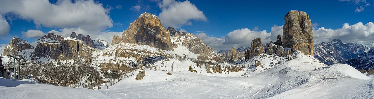
Cortina d’Ampezzo offers several ski sectors around the Ampezzo valley, rather than one compact mountain reached from a single lift. Faloria–Cristallo, Tofana and the 5 Torri–Lagazuoi area each provide a different starting point. The Cortina Skyline gondola links Son dei Prade with Bai de Dones, so a current piste map is useful even for returning visitors.
The forecast selector on this page distinguishes three named locations: the Faloria cable-car valley station at 1,225 m, the Faloria upper station at 2,123 m, and Ra Valles in the Tofana sector at 2,470 m. These are real reference points in different parts of Cortina, not three heights above a single coordinate. Choose the point closest to your intended skiing before comparing temperatures or snowfall.
If a camera shows snow while the lower forecast shows rain, check its position and elevation first. For a day involving several sectors, compare the timing of conditions at the destination and on the way back. The operator’s live lift information remains the source for actual access; neither a common ski pass nor a favourable forecast confirms that every connection is open.
Official sources: Cortina — skiing and snowboarding · Faloria · Tofana official map. Reviewed 18 October 2026.
Provider panorama/video player. Capture time is shown by the camera.
Open camera page ↗Diagramme werden vorbereitet…
Zeiten und Werte entsprechen der detaillierten Vorhersage. Tippen Sie auf einen Wert für Details und scrollen Sie seitlich für spätere Tage. Niederschlag ist das gesamte Wasseräquivalent je Intervall einschließlich Schnee. Neuschnee gilt je Intervall und ist keine Schneehöhe am Boden.
Vergleich von GFS und ECMWF. Jedes Modell behält seine eigenen Vorhersagezeiten und seinen Zeitraum. Niederschlags- und Schneemengen gelten für die jeweiligen, möglicherweise unterschiedlichen Intervalle.
ECMWF · Modelllauf: Nächste Aktualisierung erwartet:
Tag Uhrzeit (UTC) Temp. (°C) Luftfeuchtigkeit (%) Wind (km/h) Wind (Knoten) Wind (Bft) Richtung Niederschlag (mm) Neuschnee (cm) Luftdruck (hPa) Nullgradgrenze (m) Wetterlage | Mittwoch, 04/11 06:00 -2.2 94 5 3 1B SE — — 1025 < 1774 Overcast 85% cloud 09:00 -0.6 82 8 4 2B SE 0.01 0 1026 2045 Overcast 99% cloud 12:00 0.2 79 7 4 2B SE 0 0 1026 2156 Overcast 96% cloud 15:00 0.5 75 6 3 2B S 0.02 0 1025 2202 Cloudy 61% cloud 18:00 -0.7 79 5 2 1B S 0.00 0 1027 1943 Cloudy 70% cloud 21:00 -1.6 82 4 2 1B S 0 0 1029 < 1774 Cloudy 56% cloud Donnerstag, 05/11 00:00 -2.8 81 4 2 1B SW 0 0 1029 < 1774 Cloudy 57% cloud 03:00 -2.9 76 3 2 1B SW 0 0 1028 < 1774 Cloudy 58% cloud 06:00 -2.4 71 4 2 1B SW 0 0 1028 < 1774 Cloudy 52% cloud 09:00 2.2 58 5 3 1B S 0 0 1028 2643 Clear 0% cloud 12:00 4.7 49 6 3 2B S 0 0 1025 2832 Clear 0% cloud 15:00 3.4 60 3 2 1B S 0 0 1024 2917 Clear 0% cloud 18:00 0.1 66 2 1 1B SW 0 0 1026 2276 Clear 0% cloud 21:00 -0.7 63 2 1 1B S 0 0 1026 < 1774 Clear 0% cloud Freitag, 06/11 00:00 -0.7 60 3 1 1B SW 0 0 1024 < 1774 Clear 0% cloud 03:00 -0.5 59 3 1 1B SW 0 0 1023 < 1774 Clear 0% cloud 06:00 -0.2 59 3 1 1B SW 0 0 1022 < 1774 Clear 0% cloud 09:00 4.4 48 5 3 1B S 0 0 1022 3001 Clear 0% cloud 12:00 5.7 48 8 4 2B S 0 0 1020 2969 Clear 0% cloud 15:00 3.4 65 6 3 2B S 0 0 1020 2819 Partly cloudy 20% cloud 18:00 -0.1 74 4 2 1B SE 0 0 1022 2087 Partly cloudy 41% cloud 21:00 -0.6 77 7 4 2B SE 0 0 1023 1865 Overcast 100% cloud Samstag, 07/11 00:00 -0.9 81 9 5 2B SE 0.03 0 1022 1844 Overcast 100% cloud 03:00 -1.1 74 9 5 2B SE 0 0 1022 1784 Cloudy 58% cloud 06:00 -1.9 77 9 5 2B SE 0 0 1023 < 1774 Cloudy 55% cloud 09:00 0 64 12 6 2B SE 0.10 0 1024 2131 Overcast 100% cloud 12:00 0 68 10 5 2B SE 0.57 0.2 1024 2130 Overcast 99% cloud 15:00 -0.3 70 7 4 2B SE 0.03 0 1024 2071 Overcast 100% cloud 18:00 -1.7 81 6 3 2B SE 0.15 0 1025 1788 Overcast 99% cloud 21:00 -1.8 82 4 2 1B S 0.17 0 1026 < 1774 Overcast 97% cloud Sonntag, 08/11 00:00 -2.8 84 4 2 1B S 0.01 0 1026 < 1774 Cloudy 72% cloud 03:00 -3.4 90 5 3 1B SW 0.15 0.1 1025 < 1774 Overcast 98% cloud 06:00 -3.5 86 5 3 1B SW 0.55 0.5 1026 < 1774 Overcast 89% cloud 09:00 -1.6 78 6 3 2B SW 0.01 0 1026 1900 Cloudy 77% cloud 12:00 -0.3 71 6 3 2B SW 0 0 1024 2091 Overcast 97% cloud 15:00 -0.7 75 6 3 1B SW 0.03 0 1024 2024 Overcast 90% cloud 18:00 -2.4 74 6 3 1B W 0 0 1025 < 1774 Partly cloudy 42% cloud 21:00 -3.3 73 6 3 2B W 0 0 1026 < 1774 Partly cloudy 40% cloud Montag, 09/11 00:00 -3.7 74 6 3 2B W 0 0 1025 < 1774 Cloudy 55% cloud 03:00 -3 66 6 3 2B W 0 0 1025 < 1774 Overcast 84% cloud 06:00 -2.1 65 7 4 2B W 0 0 1025 < 1774 Cloudy 70% cloud 09:00 1.1 61 8 4 2B SW 0 0 1024 2461 Partly cloudy 49% cloud 12:00 2.5 62 10 5 2B SW 0 0 1022 2692 Partly cloudy 49% cloud 15:00 1 73 11 6 2B SW 0 0 1022 2480 Overcast 82% cloud 18:00 -1.1 86 11 6 2B W 0 0 1023 < 1774 Overcast 96% cloud 21:00 -0.4 91 13 7 3B W 0 0 1022 1826 Overcast 100% cloud Dienstag, 10/11 00:00 0.3 91 15 8 3B W 0.02 0 1021 2304 Overcast 100% cloud 03:00 0.7 90 14 8 3B W 0 0 1019 2571 Overcast 100% cloud 06:00 0.9 89 13 7 3B W 0 0 1018 2666 Overcast 99% cloud |
|---|
Forecast table times: UTC.
Coordinates: 46.532618°N, 12.1726708°E · Requested elevation: 2123 m. Model terrain: 1772 m. Terrain and 1000/925/850/700 hPa profiles are used for height estimates.
These are altitude estimates, not a simulation of local mountain terrain. Precipitation, cloud and sea-level pressure use horizontal interpolation only.
Precipitation includes rain and snow water equivalent: preceding 3 hours through day 6, then 6 hours (see cell tooltip). Snow (cm) estimates fresh snowfall from precipitation and temperature using the GFS conversion; it is not snow depth on the ground. Freezing (m) uses additional 600/500 hPa temperatures when available and estimates the lowest resolved 0°C crossing above sea level. When all sampled levels are warm, the upper profile limit is shown (see tooltip). < marks an entirely cold sampled profile and its lower height limit. No extrapolation is used.
Diagramme werden vorbereitet…
Zeiten und Werte entsprechen der detaillierten Vorhersage. Tippen Sie auf einen Wert für Details und scrollen Sie seitlich für spätere Tage. Niederschlag ist das gesamte Wasseräquivalent je Intervall einschließlich Schnee. Neuschnee gilt je Intervall und ist keine Schneehöhe am Boden.
Vergleich von GFS und ECMWF. Jedes Modell behält seine eigenen Vorhersagezeiten und seinen Zeitraum. Niederschlags- und Schneemengen gelten für die jeweiligen, möglicherweise unterschiedlichen Intervalle.
ECMWF · Modelllauf: Nächste Aktualisierung erwartet:
Tag Uhrzeit (UTC) Temp. (°C) Luftfeuchtigkeit (%) Wind (km/h) Wind (Knoten) Wind (Bft) Richtung Niederschlag (mm) Neuschnee (cm) Luftdruck (hPa) Nullgradgrenze (m) Wetterlage | Mittwoch, 04/11 06:00 -3.9 92 10 5 2B SE — — 1025 < 1836 Overcast 90% cloud 09:00 -2.9 87 13 7 3B SE 0.02 0 1026 2061 Overcast 98% cloud 12:00 -2.5 85 11 6 2B SE 0 0 1026 2147 Overcast 96% cloud 15:00 -1.9 77 10 5 2B S 0.03 0 1025 2174 Cloudy 67% cloud 18:00 -2.3 73 9 5 2B S 0.01 0 1027 < 1836 Cloudy 59% cloud 21:00 -2.9 74 8 5 2B S 0 0 1029 < 1836 Partly cloudy 39% cloud Donnerstag, 05/11 00:00 -3.1 68 8 4 2B SW 0 0 1028 < 1836 Partly cloudy 33% cloud 03:00 -2.7 60 8 4 2B SW 0 0 1028 < 1836 Partly cloudy 33% cloud 06:00 -1.9 54 8 5 2B S 0 0 1027 < 1836 Partly cloudy 28% cloud 09:00 0.8 50 9 5 2B S 0 0 1028 2649 Clear 1% cloud 12:00 2.3 46 7 4 2B SW 0 0 1025 2826 Clear 0% cloud 15:00 1.7 52 5 3 1B SW 0 0 1024 2898 Clear 0% cloud 18:00 -0.3 51 3 2 1B S 0 0 1025 < 1836 Clear 0% cloud 21:00 -0.6 49 4 2 1B S 0 0 1025 < 1836 Clear 0% cloud Freitag, 06/11 00:00 -0.3 46 6 3 1B S 0 0 1024 < 1836 Clear 0% cloud 03:00 -0.2 49 6 3 2B SW 0 0 1023 < 1836 Clear 0% cloud 06:00 -0.2 51 6 3 1B S 0 0 1022 1994 Clear 0% cloud 09:00 2.7 46 9 5 2B S 0 0 1022 2998 Clear 0% cloud 12:00 3.4 46 10 5 2B S 0 0 1020 2964 Clear 1% cloud 15:00 1.6 57 9 5 2B S 0 0 1020 2806 Clear 16% cloud 18:00 -0.9 61 8 5 2B SE 0 0 1021 1880 Partly cloudy 38% cloud 21:00 -1.3 61 14 7 3B SE 0 0 1022 1975 Overcast 100% cloud Samstag, 07/11 00:00 -1.8 69 18 10 3B SE 0.07 0 1022 1940 Overcast 99% cloud 03:00 -2.3 62 18 10 3B SE 0 0 1021 < 1836 Cloudy 51% cloud 06:00 -3.2 70 18 10 3B SE 0 0 1023 < 1836 Cloudy 64% cloud 09:00 -2.3 66 20 11 4B SE 0.20 0 1024 2122 Overcast 100% cloud 12:00 -2.4 77 17 9 3B SE 0.69 0.2 1024 2132 Overcast 98% cloud 15:00 -2.6 79 10 5 2B SE 0.07 0 1024 2034 Overcast 100% cloud 18:00 -3.4 87 10 5 2B SE 0.28 0.3 1025 < 1836 Overcast 99% cloud 21:00 -3.6 86 8 4 2B S 0.23 0.2 1026 < 1836 Overcast 94% cloud Sonntag, 08/11 00:00 -4.4 84 9 5 2B S 0.01 0 1026 < 1836 Overcast 84% cloud 03:00 -4.9 90 9 5 2B SW 0.07 0.1 1025 < 1836 Overcast 95% cloud 06:00 -5 85 9 5 2B SW 0.39 0.4 1025 < 1836 Overcast 85% cloud 09:00 -4.1 82 10 5 2B SW 0.01 0 1026 1900 Overcast 88% cloud 12:00 -3.1 76 10 5 2B SW 0 0 1024 2096 Overcast 97% cloud 15:00 -3.2 76 9 5 2B W 0.07 0.1 1024 2040 Overcast 91% cloud 18:00 -3.8 61 10 6 2B W 0 0 1025 < 1836 Partly cloudy 40% cloud 21:00 -4.3 59 11 6 2B W 0 0 1026 < 1836 Partly cloudy 38% cloud Montag, 09/11 00:00 -4.3 60 12 6 2B W 0 0 1025 < 1836 Partly cloudy 35% cloud 03:00 -3.3 54 10 6 2B W 0 0 1024 < 1836 Overcast 81% cloud 06:00 -2.5 58 12 6 2B W 0 0 1025 < 1836 Cloudy 60% cloud 09:00 -0.1 56 13 7 3B W 0 0 1024 2456 Partly cloudy 46% cloud 12:00 1 58 15 8 3B SW 0 0 1021 2688 Partly cloudy 41% cloud 15:00 0 67 19 10 3B W 0 0 1021 2473 Overcast 81% cloud 18:00 -1.4 79 19 10 3B W 0 0 1023 < 1836 Overcast 93% cloud 21:00 -0.9 87 24 13 4B W 0 0 1022 1940 Overcast 100% cloud Dienstag, 10/11 00:00 -0.4 89 27 15 4B W 0.02 0 1021 2273 Overcast 100% cloud 03:00 0 88 25 14 4B W 0 0 1019 2498 Overcast 100% cloud 06:00 0.2 88 24 13 4B W 0 0 1018 2574 Overcast 100% cloud |
|---|
Forecast table times: UTC.
Coordinates: 46.5477918°N, 12.0851004°E · Requested elevation: 2470 m. Model terrain: 1833 m. Terrain and 1000/925/850/700 hPa profiles are used for height estimates.
These are altitude estimates, not a simulation of local mountain terrain. Precipitation, cloud and sea-level pressure use horizontal interpolation only.
Precipitation includes rain and snow water equivalent: preceding 3 hours through day 6, then 6 hours (see cell tooltip). Snow (cm) estimates fresh snowfall from precipitation and temperature using the GFS conversion; it is not snow depth on the ground. Freezing (m) uses additional 600/500 hPa temperatures when available and estimates the lowest resolved 0°C crossing above sea level. When all sampled levels are warm, the upper profile limit is shown (see tooltip). < marks an entirely cold sampled profile and its lower height limit. No extrapolation is used.