全球滑雪场天气预报

颜色说明 温度 · 风 · 降雨 · 降雪
每种颜色从所示数值开始。三种风速单位的颜色相互对应。无降水单元格保持中性色。颜色仅描述显示值,并非官方天气预警。
正在准备预报图表…
时间和数值与详细预报一致。点击数值查看详情,横向滚动查看后续日期。降水量为每时段总水当量,包含降雪;新雪量指每时段新增降雪,并非地面积雪深度。
GFS与ECMWF模式对比。各模式保留各自的预报时间和时长。降水量和降雪量对应各模式自身的时段,模式之间的时段可能不同。
预报数值与模式说明
Campgaw Mountain Ski Area - Low lift station
ECMWF · 模式起报时间: 预计下次更新:
日期 时间(UTC) 气温(°C) 湿度(%) 风速(km/h) 风速(节) 风力(Bft) 风向 降水(mm) 新雪(cm) 气压(hPa) 零度层(m) 天气状况 | 星期三, 04/11 06:00 11.7 87 9 5 2B SW — — 1023 3171 Clear 0% cloud  09:00 11.2 88 7 4 2B SW 0 0 1022 3163 Clear 0% cloud 12:00 10.8 89 6 3 2B SW 0 0 1022 3165 Clear 0% cloud 15:00 17.2 65 8 4 2B S 0 0 1021 3158 Clear 0% cloud 18:00 21 52 13 7 3B SW 0 0 1019 3147 Clear 0% cloud 21:00 19.8 57 10 5 2B S 0 0 1018 3141 Clear 10% cloud 星期四, 05/11 00:00 15.3 77 8 4 2B S 0 0 1018 3138 Partly cloudy 32% cloud  03:00 13.7 85 9 5 2B SW 0 0 1017 3131 Partly cloudy 39% cloud 06:00 13.6 99 9 5 2B S 0 0 1016 3118 Overcast 84% cloud  09:00 13.9 100 10 5 2B S 0 0 1015 3107 Overcast 100% cloud 12:00 15 99 12 7 3B S 0 0 1015 3104 Overcast 100% cloud 15:00 17.5 93 15 8 3B S 0.04 0 1014 3102 Overcast 100% cloud 18:00 20.4 78 18 10 3B S 0.52 0 1011 3086 Overcast 98% cloud 21:00 20.6 79 12 7 3B S 0.15 0 1011 3084 Overcast 100% cloud 星期五, 06/11 00:00 18.8 90 13 7 3B S 0.12 0 1011 3089 Cloudy 69% cloud  03:00 17.9 96 12 6 2B SW 0.23 0 1012 3089 Overcast 100% cloud 06:00 17.2 99 8 4 2B SW 1.4 0 1011 3082 Overcast 96% cloud 09:00 16.1 99 4 2 1B W 0.14 0 1011 3076 Overcast 96% cloud 12:00 15.1 100 2 1 1B W 0 0 1013 3078 Overcast 98% cloud 15:00 19.4 79 1 1 1B S 0 0 1013 3080 Overcast 91% cloud 18:00 21.8 60 7 4 2B S 0.02 0 1011 3066 Overcast 97% cloud 21:00 19.9 69 5 3 1B S 0.01 0 1011 3058 Overcast 96% cloud 星期六, 07/11 00:00 16 84 4 2 1B W 0 0 1011 3055 Overcast 100% cloud 03:00 14.6 78 7 4 2B NW 0 0 1011 3016 Overcast 100% cloud 06:00 13.5 85 12 6 2B N 0 0 1010 2952 Overcast 100% cloud 09:00 12.3 86 10 5 2B N 0 0 1009 2843 Clear 11% cloud 12:00 11.6 89 10 5 2B N 0 0 1009 2774 Clear 19% cloud 15:00 16.6 69 6 3 2B NW 0 0 1009 2606 Partly cloudy 49% cloud 18:00 17.7 61 8 4 2B NW 0.02 0 1008 2357 Overcast 93% cloud 21:00 13 72 18 10 3B NW 1.3 0 1009 2224 Cloudy 60% cloud 星期日, 08/11 00:00 9.3 72 17 9 3B NW 0.06 0 1010 1733 Clear 18% cloud 03:00 8.6 76 18 9 3B W 0.07 0 1009 1537 Overcast 96% cloud 06:00 7.8 92 18 10 3B W 1.9 0 1008 1813 Overcast 93% cloud 09:00 8 88 21 11 4B NW 1.2 0 1009 2057 Overcast 83% cloud 12:00 9.2 75 19 10 3B NW 0 0 1011 1949 Cloudy 75% cloud 15:00 12.5 61 22 12 4B NW 0 0 1011 1745 Cloudy 75% cloud 18:00 12.7 55 18 10 3B W 0.02 0 1010 1407 Cloudy 66% cloud 21:00 13 51 11 6 2B W 0 0 1009 2336 Clear 1% cloud 星期一, 09/11 00:00 10 61 14 7 3B W 0 0 1008 2268 Clear 0% cloud 03:00 8.9 54 14 8 3B W 0 0 1008 2053 Clear 8% cloud 06:00 8.6 58 13 7 3B W 0 0 1007 1688 Partly cloudy 21% cloud 09:00 8.7 68 15 8 3B W 0.03 0 1007 1506 Partly cloudy 37% cloud 12:00 8 73 18 10 3B W 0.05 0 1009 1187 Cloudy 52% cloud 15:00 10.4 58 25 13 4B NW 0.02 0 1010 1189 Overcast 88% cloud 18:00 11 52 23 13 4B NW 0.02 0 1011 1219 Overcast 88% cloud 21:00 10.2 54 22 12 4B NW 0 0 1013 1225 Cloudy 74% cloud 星期二, 10/11 00:00 8 67 16 9 3B NW 0 0 1015 1449 Partly cloudy 29% cloud 03:00 7.2 68 13 7 3B NW 0 0 1016 2464 Partly cloudy 45% cloud 06:00 7.1 70 12 7 2B W 0 0 1016 2974 Cloudy 54% cloud |
|---|
Forecast notes
Forecast table times: UTC.
Coordinates: 41.0600197°N, -74.1958093°E · Requested elevation: 146 m. Model terrain: 143 m. Terrain and 1000/925/850/700 hPa profiles are used for height estimates.
These are altitude estimates, not a simulation of local mountain terrain. Precipitation, cloud and sea-level pressure use horizontal interpolation only.
Precipitation includes rain and snow water equivalent: preceding 3 hours through day 6, then 6 hours (see cell tooltip). Snow (cm) estimates fresh snowfall from precipitation and temperature using the GFS conversion; it is not snow depth on the ground. Freezing (m) uses additional 600/500 hPa temperatures when available and estimates the lowest resolved 0°C crossing above sea level. When all sampled levels are warm, the upper profile limit is shown (see tooltip). < marks an entirely cold sampled profile and its lower height limit. No extrapolation is used.
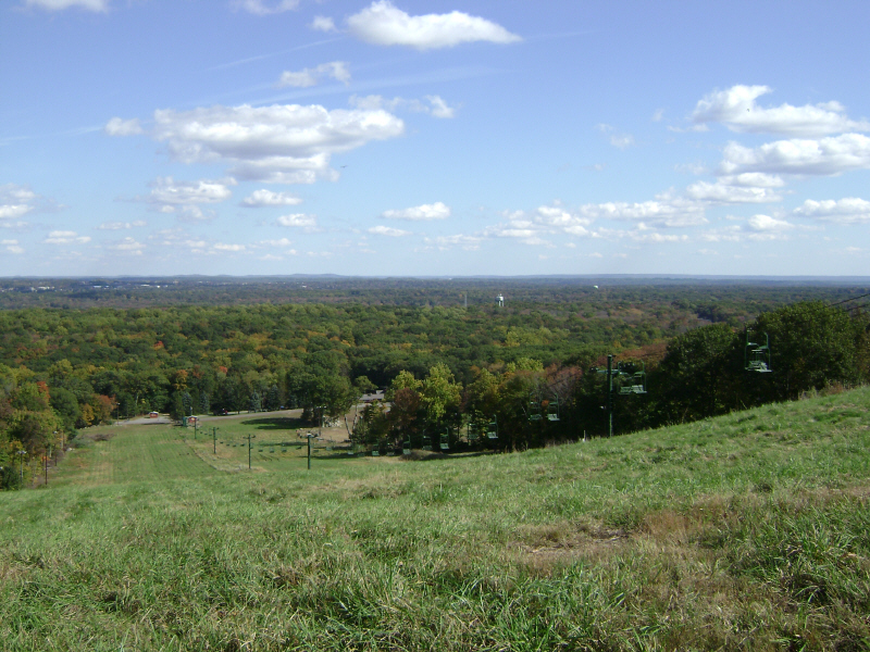
Campgaw Mountain Ski Area is a downhill ski area in New Jersey, United States. Mapped terrain includes beginner, easy, intermediate, advanced, expert routes. Its mapped lift network extends from approximately 146 to 221 metres above sea level.
Data: OpenSkiData / OpenSkiMap, OpenStreetMap contributors (ODbL), Skimap.org, Who's On First, Mapterhorn.
正在准备预报图表…
时间和数值与详细预报一致。点击数值查看详情,横向滚动查看后续日期。降水量为每时段总水当量,包含降雪;新雪量指每时段新增降雪,并非地面积雪深度。
GFS与ECMWF模式对比。各模式保留各自的预报时间和时长。降水量和降雪量对应各模式自身的时段,模式之间的时段可能不同。
预报数值与模式说明
Campgaw Mountain Ski Area - Base lift station
ECMWF · 模式起报时间: 预计下次更新:
日期 时间(UTC) 气温(°C) 湿度(%) 风速(km/h) 风速(节) 风力(Bft) 风向 降水(mm) 新雪(cm) 气压(hPa) 零度层(m) 天气状况 | 星期三, 04/11 06:00 11.7 87 9 5 2B SW — — 1023 3171 Clear 0% cloud 09:00 11.2 88 7 4 2B SW 0 0 1022 3163 Clear 0% cloud 12:00 10.8 89 6 3 2B SW 0 0 1022 3165 Clear 0% cloud 15:00 17.2 65 8 4 2B S 0 0 1021 3158 Clear 0% cloud 18:00 20.9 52 13 7 3B SW 0 0 1019 3147 Clear 0% cloud 21:00 19.8 57 10 5 2B S 0 0 1018 3141 Clear 10% cloud 星期四, 05/11 00:00 15.3 77 8 4 2B S 0 0 1018 3138 Partly cloudy 32% cloud 03:00 13.7 85 9 5 2B SW 0 0 1017 3131 Partly cloudy 39% cloud 06:00 13.6 99 9 5 2B S 0 0 1016 3118 Overcast 84% cloud 09:00 13.9 100 10 5 2B S 0 0 1015 3107 Overcast 100% cloud 12:00 15 99 13 7 3B S 0 0 1015 3104 Overcast 100% cloud 15:00 17.5 93 15 8 3B S 0.04 0 1014 3102 Overcast 100% cloud 18:00 20.4 78 18 10 3B S 0.51 0 1011 3086 Overcast 98% cloud 21:00 20.5 79 13 7 3B S 0.14 0 1011 3084 Overcast 100% cloud 星期五, 06/11 00:00 18.7 90 13 7 3B S 0.12 0 1011 3089 Cloudy 69% cloud 03:00 17.9 96 12 6 2B SW 0.23 0 1012 3089 Overcast 100% cloud 06:00 17.2 99 8 5 2B SW 1.4 0 1011 3082 Overcast 96% cloud 09:00 16.1 99 4 2 1B W 0.14 0 1011 3076 Overcast 96% cloud 12:00 15.1 100 2 1 1B W 0 0 1013 3078 Overcast 98% cloud 15:00 19.4 79 1 1 1B S 0 0 1013 3080 Overcast 91% cloud 18:00 21.7 60 7 4 2B S 0.02 0 1011 3066 Overcast 97% cloud 21:00 19.9 69 5 3 1B S 0.01 0 1011 3058 Overcast 96% cloud 星期六, 07/11 00:00 16 84 4 2 1B W 0 0 1011 3055 Overcast 100% cloud 03:00 14.6 78 7 4 2B NW 0 0 1011 3016 Overcast 100% cloud 06:00 13.5 85 12 6 2B N 0 0 1010 2952 Overcast 100% cloud 09:00 12.3 86 10 5 2B N 0 0 1009 2843 Clear 11% cloud 12:00 11.6 89 10 5 2B N 0 0 1009 2774 Clear 19% cloud 15:00 16.6 69 6 3 2B NW 0 0 1009 2606 Partly cloudy 49% cloud 18:00 17.7 61 8 4 2B NW 0.02 0 1008 2357 Overcast 93% cloud 21:00 13 72 19 10 3B NW 1.3 0 1009 2224 Cloudy 60% cloud 星期日, 08/11 00:00 9.3 72 17 9 3B NW 0.06 0 1010 1733 Clear 18% cloud 03:00 8.6 76 18 10 3B W 0.07 0 1009 1537 Overcast 96% cloud 06:00 7.7 92 19 10 3B W 1.9 0 1008 1813 Overcast 93% cloud 09:00 8 88 21 12 4B NW 1.2 0 1009 2057 Overcast 83% cloud 12:00 9.2 75 19 10 3B NW 0 0 1011 1950 Cloudy 75% cloud 15:00 12.5 61 22 12 4B NW 0 0 1011 1745 Cloudy 75% cloud 18:00 12.7 55 18 10 3B W 0.02 0 1010 1407 Cloudy 66% cloud 21:00 12.9 51 11 6 2B W 0 0 1009 2337 Clear 1% cloud 星期一, 09/11 00:00 10 61 14 8 3B W 0 0 1009 2269 Clear 0% cloud 03:00 8.9 54 14 8 3B W 0 0 1008 2053 Clear 8% cloud 06:00 8.6 58 13 7 3B W 0 0 1007 1688 Partly cloudy 21% cloud 09:00 8.7 68 15 8 3B W 0.03 0 1007 1506 Partly cloudy 37% cloud 12:00 7.9 73 18 10 3B W 0.05 0 1009 1187 Cloudy 52% cloud 15:00 10.4 58 25 13 4B NW 0.02 0 1010 1189 Overcast 88% cloud 18:00 10.9 52 23 13 4B NW 0.02 0 1011 1219 Overcast 88% cloud 21:00 10.2 54 22 12 4B NW 0 0 1013 1225 Cloudy 74% cloud 星期二, 10/11 00:00 8 67 16 9 3B NW 0 0 1015 1449 Partly cloudy 29% cloud 03:00 7.2 68 13 7 3B NW 0 0 1016 2464 Partly cloudy 45% cloud 06:00 7.1 70 12 7 3B W 0 0 1016 2974 Cloudy 54% cloud |
|---|
Forecast notes
Forecast table times: UTC.
Coordinates: 41.0594238°N, -74.1956067°E · Requested elevation: 148 m. Model terrain: 142 m. Terrain and 1000/925/850/700 hPa profiles are used for height estimates.
These are altitude estimates, not a simulation of local mountain terrain. Precipitation, cloud and sea-level pressure use horizontal interpolation only.
Precipitation includes rain and snow water equivalent: preceding 3 hours through day 6, then 6 hours (see cell tooltip). Snow (cm) estimates fresh snowfall from precipitation and temperature using the GFS conversion; it is not snow depth on the ground. Freezing (m) uses additional 600/500 hPa temperatures when available and estimates the lowest resolved 0°C crossing above sea level. When all sampled levels are warm, the upper profile limit is shown (see tooltip). < marks an entirely cold sampled profile and its lower height limit. No extrapolation is used.
正在准备预报图表…
时间和数值与详细预报一致。点击数值查看详情,横向滚动查看后续日期。降水量为每时段总水当量,包含降雪;新雪量指每时段新增降雪,并非地面积雪深度。
GFS与ECMWF模式对比。各模式保留各自的预报时间和时长。降水量和降雪量对应各模式自身的时段,模式之间的时段可能不同。
预报数值与模式说明
Campgaw Mountain Ski Area - Top lift station
ECMWF · 模式起报时间: 预计下次更新:
日期 时间(UTC) 气温(°C) 湿度(%) 风速(km/h) 风速(节) 风力(Bft) 风向 降水(mm) 新雪(cm) 气压(hPa) 零度层(m) 天气状况 | 星期三, 04/11 06:00 12 82 11 6 2B SW — — 1023 3171 Clear 0% cloud 09:00 11.5 84 11 6 2B SW 0 0 1022 3163 Clear 0% cloud 12:00 11.2 85 10 5 2B SW 0 0 1022 3165 Clear 0% cloud 15:00 16.9 65 11 6 2B SW 0 0 1021 3158 Clear 0% cloud 18:00 20.2 54 15 8 3B SW 0 0 1019 3147 Clear 0% cloud 21:00 19.2 58 12 7 3B SW 0 0 1018 3141 Clear 10% cloud 星期四, 05/11 00:00 15.2 74 11 6 2B SW 0 0 1018 3138 Partly cloudy 32% cloud 03:00 13.8 83 13 7 3B SW 0 0 1017 3130 Partly cloudy 39% cloud 06:00 13.7 95 13 7 3B S 0 0 1016 3118 Overcast 84% cloud 09:00 13.9 100 15 8 3B SW 0 0 1015 3107 Overcast 100% cloud 12:00 15 99 18 10 3B S 0 0 1015 3104 Overcast 100% cloud 15:00 17.2 94 21 11 4B S 0.04 0 1014 3102 Overcast 100% cloud 18:00 19.7 80 21 12 4B SW 0.51 0 1011 3086 Overcast 98% cloud 21:00 20 81 16 9 3B SW 0.15 0 1011 3084 Overcast 100% cloud 星期五, 06/11 00:00 18.4 91 17 9 3B SW 0.12 0 1011 3089 Cloudy 69% cloud 03:00 17.6 96 16 9 3B SW 0.22 0 1012 3089 Overcast 100% cloud 06:00 16.9 98 12 7 2B SW 1.4 0 1011 3082 Overcast 96% cloud 09:00 16.1 97 6 3 2B W 0.14 0 1011 3076 Overcast 96% cloud 12:00 15.1 97 3 2 1B W 0 0 1013 3078 Overcast 98% cloud 15:00 18.8 80 2 1 1B SW 0 0 1013 3080 Overcast 91% cloud 18:00 20.9 62 7 4 2B S 0.02 0 1011 3066 Overcast 97% cloud 21:00 19.4 70 6 3 1B S 0.01 0 1011 3058 Overcast 96% cloud 星期六, 07/11 00:00 15.9 81 5 3 1B W 0 0 1011 3055 Overcast 100% cloud 03:00 14.5 76 7 4 2B NW 0 0 1011 3015 Overcast 100% cloud 06:00 13.5 83 13 7 3B N 0 0 1010 2952 Overcast 100% cloud 09:00 12.4 86 10 5 2B N 0 0 1009 2842 Clear 11% cloud 12:00 11.7 88 10 5 2B N 0 0 1009 2773 Clear 19% cloud 15:00 15.9 72 7 4 2B NW 0 0 1009 2603 Partly cloudy 48% cloud 18:00 16.9 63 9 5 2B NW 0.02 0 1008 2356 Overcast 92% cloud 21:00 12.3 73 21 11 4B NW 1.3 0 1009 2222 Cloudy 61% cloud 星期日, 08/11 00:00 8.7 74 22 12 4B NW 0.06 0 1010 1730 Clear 18% cloud 03:00 7.9 78 22 12 4B W 0.07 0 1009 1536 Overcast 97% cloud 06:00 7.3 92 24 13 4B NW 1.9 0 1008 1816 Overcast 93% cloud 09:00 7.6 89 28 15 4B NW 1.2 0 1009 2057 Overcast 83% cloud 12:00 8.7 77 25 13 4B NW 0 0 1011 1950 Cloudy 74% cloud 15:00 11.7 63 25 13 4B NW 0 0 1011 1743 Cloudy 75% cloud 18:00 11.9 57 21 11 4B W 0.02 0 1010 1407 Cloudy 65% cloud 21:00 12.3 52 14 8 3B W 0 0 1009 2338 Clear 1% cloud 星期一, 09/11 00:00 9.6 60 19 10 3B W 0 0 1009 2269 Clear 0% cloud 03:00 8.7 53 20 11 4B W 0 0 1008 2055 Clear 8% cloud 06:00 8.3 58 18 10 3B W 0 0 1007 1690 Partly cloudy 21% cloud 09:00 8.3 69 20 11 4B W 0.03 0 1007 1507 Partly cloudy 35% cloud 12:00 7.4 75 23 12 4B W 0.05 0 1009 1187 Cloudy 52% cloud 15:00 9.6 61 28 15 4B NW 0.02 0 1010 1190 Overcast 89% cloud 18:00 10.1 54 27 14 4B NW 0.02 0 1011 1219 Overcast 88% cloud 21:00 9.5 56 26 14 4B NW 0 0 1013 1225 Cloudy 74% cloud 星期二, 10/11 00:00 7.4 68 21 12 4B NW 0 0 1015 1453 Partly cloudy 29% cloud 03:00 6.6 69 18 10 3B NW 0 0 1016 2469 Partly cloudy 45% cloud 06:00 6.5 71 17 9 3B NW 0 0 1016 2977 Cloudy 54% cloud |
|---|
Forecast notes
Forecast table times: UTC.
Coordinates: 41.0586139°N, -74.2005724°E · Requested elevation: 221 m. Model terrain: 143 m. Terrain and 1000/925/850/700 hPa profiles are used for height estimates.
These are altitude estimates, not a simulation of local mountain terrain. Precipitation, cloud and sea-level pressure use horizontal interpolation only.
Precipitation includes rain and snow water equivalent: preceding 3 hours through day 6, then 6 hours (see cell tooltip). Snow (cm) estimates fresh snowfall from precipitation and temperature using the GFS conversion; it is not snow depth on the ground. Freezing (m) uses additional 600/500 hPa temperatures when available and estimates the lowest resolved 0°C crossing above sea level. When all sampled levels are warm, the upper profile limit is shown (see tooltip). < marks an entirely cold sampled profile and its lower height limit. No extrapolation is used.