Arabba · Porta Vescovo · Panorama

Provider panorama/video player. Capture time is shown by the camera.
Open camera page ↗
Ogni colore inizia dal valore indicato. I colori del vento corrispondono nelle tre unità di misura. Le celle senza precipitazioni restano neutre. I colori descrivono i valori visualizzati, non avvisi meteo ufficiali.
Preparazione dei grafici…
Orari e valori corrispondono alla previsione dettagliata. Tocca un valore o passaci sopra per i dettagli. Scorri orizzontalmente ogni grafico per i giorni successivi. Pioggia / precipitazioni indica l’equivalente totale in acqua per intervallo, inclusa la neve; la nevicata indica la neve fresca per intervallo, non l’altezza del manto nevoso.
Confronto dei modelli GFS ed ECMWF. Ogni modello mantiene i propri orari e il proprio orizzonte di previsione. Le quantità di precipitazioni e neve si riferiscono ai rispettivi intervalli, che possono differire tra i modelli.
ECMWF · Elaborazione del modello: Prossimo aggiornamento previsto:
Giorno Ora (UTC) Temp. (°C) Umidità (%) Vento (km/h) Vento (nodi) Vento (Bft) Direzione Precip. (mm) Neve (cm) Pressione (hPa) Zero termico (m) Condizioni | Mercoledì, 04/11 06:00 1.2 83 2 1 1B E — — 1025 < 1996 Cloudy 80% cloud  09:00 3.2 68 5 3 1B SE 0.00 0 1025 2131 Overcast 100% cloud  12:00 3.5 69 4 2 1B SE 0.03 0 1026 2172 Overcast 100% cloud 15:00 3 71 3 2 1B SE 0.03 0 1026 2142 Cloudy 75% cloud 18:00 0.6 82 1 0 0B SE 0.00 0 1027 < 1996 Cloudy 69% cloud 21:00 -0 82 1 0 0B NE 0 0 1029 < 1996 Partly cloudy 20% cloud  Giovedì, 05/11 00:00 -0.5 81 1 0 0B N 0 0 1028 < 1996 Clear 15% cloud  03:00 -0.5 77 1 1 1B N 0 0 1027 < 1996 Clear 10% cloud 06:00 0.1 73 0 0 0B NE 0 0 1027 < 1996 Clear 1% cloud 09:00 5.3 56 2 1 1B S 0 0 1027 2664 Clear 0% cloud 12:00 7.4 50 3 2 1B S 0 0 1025 2800 Clear 0% cloud 15:00 5 68 0 0 0B S 0 0 1025 2832 Clear 0% cloud 18:00 1.3 72 1 1 1B NW 0 0 1026 < 1996 Clear 0% cloud 21:00 1.3 71 1 0 0B N 0 0 1025 < 1996 Clear 0% cloud Venerdì, 06/11 00:00 1.9 65 0 0 0B NW 0 0 1024 < 1996 Clear 0% cloud 03:00 2.3 60 0 0 0B NE 0 0 1022 2288 Clear 0% cloud 06:00 2.5 59 0 0 0B S 0 0 1022 2405 Clear 0% cloud 09:00 7.6 47 3 2 1B S 0 0 1021 2970 Clear 5% cloud 12:00 9 48 4 2 1B S 0 0 1020 2960 Clear 3% cloud 15:00 5.5 68 2 1 1B SE 0 0 1020 2767 Clear 19% cloud 18:00 1.4 80 1 1 1B NE 0 0 1021 < 1996 Cloudy 66% cloud 21:00 2.6 80 2 1 1B E 0 0 1022 2148 Overcast 100% cloud Sabato, 07/11 00:00 2.4 78 1 1 1B E 0.12 0 1022 2062 Overcast 98% cloud 03:00 1.5 70 1 1 0B E 0.06 0 1021 < 1996 Partly cloudy 47% cloud 06:00 1.3 65 1 1 0B SE 0.00 0 1023 < 1996 Overcast 85% cloud 09:00 2.6 61 4 2 1B E 0.57 0 1024 2076 Overcast 100% cloud 12:00 3.3 60 4 2 1B SE 0.79 0 1023 2160 Overcast 100% cloud 15:00 2.1 64 3 1 1B SE 0.12 0 1024 < 1996 Overcast 100% cloud 18:00 0.8 78 2 1 1B SE 0.37 0.1 1025 < 1996 Overcast 100% cloud 21:00 0.6 79 1 1 1B E 0.30 0.1 1026 < 1996 Overcast 93% cloud Domenica, 08/11 00:00 -0 79 1 1 0B E 0 0 1026 < 1996 Overcast 97% cloud 03:00 -0.6 79 1 0 0B E 0.13 0 1025 < 1996 Overcast 98% cloud 06:00 0 76 1 0 0B SW 0.30 0.1 1025 < 1996 Overcast 88% cloud 09:00 1.7 73 4 2 1B SW 0 0 1026 < 1996 Overcast 98% cloud 12:00 3.1 64 5 2 1B SW 0.06 0 1024 2114 Overcast 86% cloud 15:00 2.4 68 3 1 1B SW 0.06 0 1024 2038 Overcast 82% cloud 18:00 -0.9 82 1 0 0B E 0 0 1026 < 1996 Cloudy 61% cloud 21:00 -2.8 83 1 0 0B N 0 0 1026 < 1996 Partly cloudy 50% cloud Lunedì, 09/11 00:00 -3.9 82 2 1 1B NW 0 0 1025 < 1996 Clear 18% cloud 03:00 -1.8 68 1 0 0B NW 0 0 1024 < 1996 Cloudy 71% cloud 06:00 -0.8 64 0 0 0B NW 0 0 1024 < 1996 Cloudy 59% cloud 09:00 3.7 57 3 2 1B SW 0 0 1024 2461 Partly cloudy 45% cloud 12:00 5.2 58 5 3 1B SW 0 0 1021 2646 Partly cloudy 35% cloud 15:00 3.3 73 4 2 1B SW 0 0 1021 2365 Overcast 88% cloud 18:00 0.6 84 2 1 1B SW 0 0 1022 < 1996 Overcast 93% cloud 21:00 2.4 85 3 1 1B SW 0.00 0 1022 2090 Overcast 100% cloud Martedì, 10/11 00:00 2.6 87 2 1 1B SW 0.06 0 1020 2205 Overcast 100% cloud 03:00 3 87 2 1 1B SW 0.00 0 1018 2416 Overcast 100% cloud 06:00 3.1 87 1 1 1B SW 0.00 0 1017 2483 Overcast 100% cloud |
|---|
Forecast table times: UTC.
Coordinates: 46.4956308°N, 11.8740293°E · Requested elevation: 1607 m. Model terrain: 1994 m. Terrain and 1000/925/850/700 hPa profiles are used for height estimates.
Outside the available profile, temperature uses an estimated 5.5°C/km height correction; wind retains the nearest available model-level value. Humidity is estimated with adjusted pressure and temperature.
These are altitude estimates, not a simulation of local mountain terrain. Precipitation, cloud and sea-level pressure use horizontal interpolation only.
Precipitation includes rain and snow water equivalent: preceding 3 hours through day 6, then 6 hours (see cell tooltip). Snow (cm) estimates fresh snowfall from precipitation and temperature using the GFS conversion; it is not snow depth on the ground. Freezing (m) uses additional 600/500 hPa temperatures when available and estimates the lowest resolved 0°C crossing above sea level. When all sampled levels are warm, the upper profile limit is shown (see tooltip). < marks an entirely cold sampled profile and its lower height limit. No extrapolation is used.
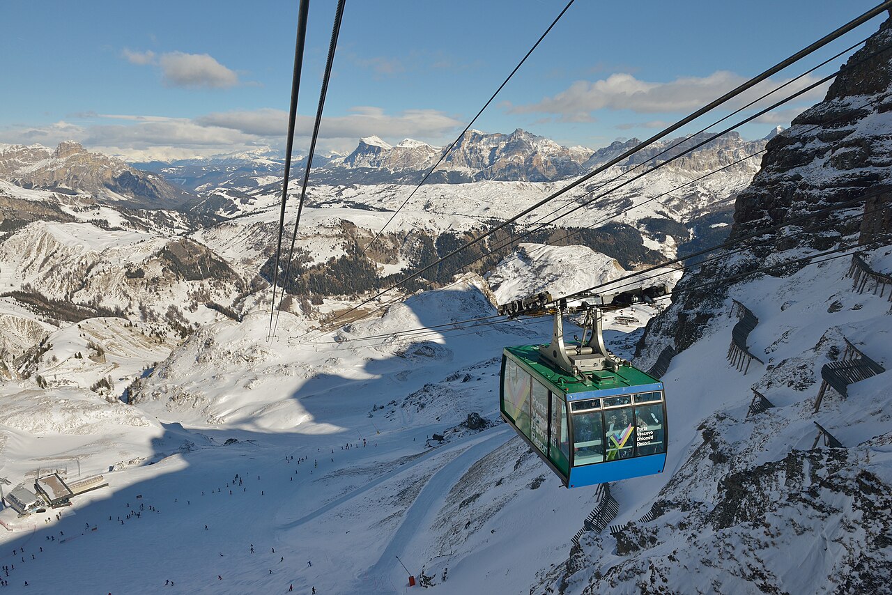
Arabba lies on the Sellaronda network, with Porta Vescovo providing a distinct high-mountain sector between the Sella landscape and the Marmolada. The Arabba–Marmolada map also shows the Pordoi, Padon and Campolongo connections. That geography makes Arabba a starting point for different kinds of day: local runs, part of the Sella circuit, or a longer excursion towards the Marmolada.
These choices are not interchangeable. Trace the actual route on the piste map and look at the difficulty markings, connections and return journey. A regional name on your ski pass is not evidence that every connecting lift is operating. The linked official map is the 2025–26 edition; consult the operator’s current information for changes before travelling.
This page’s lower reference is at 1,607 m. For Porta Vescovo or a higher excursion, select the appropriate elevation and compare the timing of wind, cloud and precipitation. If both models forecast snow but disagree on when it arrives, that may matter more for a day-long circuit than a small difference in the final total. A lower camera can show a different precipitation type from a higher one during the same episode.
Official sources: Arabba — Porta Vescovo · Arabba–Marmolada piste map. Reviewed 18 October 2026.
Provider panorama/video player. Capture time is shown by the camera.
Open camera page ↗Preparazione dei grafici…
Orari e valori corrispondono alla previsione dettagliata. Tocca un valore o passaci sopra per i dettagli. Scorri orizzontalmente ogni grafico per i giorni successivi. Pioggia / precipitazioni indica l’equivalente totale in acqua per intervallo, inclusa la neve; la nevicata indica la neve fresca per intervallo, non l’altezza del manto nevoso.
Confronto dei modelli GFS ed ECMWF. Ogni modello mantiene i propri orari e il proprio orizzonte di previsione. Le quantità di precipitazioni e neve si riferiscono ai rispettivi intervalli, che possono differire tra i modelli.
ECMWF · Elaborazione del modello: Prossimo aggiornamento previsto:
Giorno Ora (UTC) Temp. (°C) Umidità (%) Vento (km/h) Vento (nodi) Vento (Bft) Direzione Precip. (mm) Neve (cm) Pressione (hPa) Zero termico (m) Condizioni | Mercoledì, 04/11 06:00 1.2 83 2 1 1B E — — 1025 < 1996 Cloudy 80% cloud 09:00 3.1 68 5 3 1B SE 0.00 0 1025 2131 Overcast 100% cloud 12:00 3.5 69 4 2 1B SE 0.03 0 1026 2172 Overcast 100% cloud 15:00 3 71 3 2 1B SE 0.03 0 1026 2142 Cloudy 75% cloud 18:00 0.6 82 1 0 0B SE 0.00 0 1027 < 1996 Cloudy 69% cloud 21:00 -0 82 1 0 0B NE 0 0 1029 < 1996 Partly cloudy 21% cloud Giovedì, 05/11 00:00 -0.5 81 1 0 0B N 0 0 1028 < 1996 Clear 15% cloud 03:00 -0.5 77 1 1 1B N 0 0 1027 < 1996 Clear 10% cloud 06:00 0.1 73 0 0 0B N 0 0 1027 < 1996 Clear 1% cloud 09:00 5.3 56 2 1 1B S 0 0 1027 2664 Clear 0% cloud 12:00 7.4 50 4 2 1B S 0 0 1025 2800 Clear 0% cloud 15:00 5 68 0 0 0B S 0 0 1025 2832 Clear 0% cloud 18:00 1.3 72 1 1 1B NW 0 0 1026 < 1996 Clear 0% cloud 21:00 1.3 71 1 0 0B N 0 0 1025 < 1996 Clear 0% cloud Venerdì, 06/11 00:00 1.9 65 0 0 0B NW 0 0 1024 < 1996 Clear 0% cloud 03:00 2.2 60 0 0 0B NE 0 0 1022 2288 Clear 0% cloud 06:00 2.5 59 0 0 0B S 0 0 1022 2405 Clear 0% cloud 09:00 7.6 47 3 2 1B S 0 0 1021 2970 Clear 5% cloud 12:00 9 48 4 2 1B S 0 0 1020 2960 Clear 3% cloud 15:00 5.5 68 2 1 1B SE 0 0 1020 2767 Clear 19% cloud 18:00 1.4 80 1 1 1B NE 0 0 1021 < 1996 Cloudy 66% cloud 21:00 2.6 80 2 1 1B E 0 0 1022 2148 Overcast 100% cloud Sabato, 07/11 00:00 2.4 78 1 1 1B E 0.12 0 1022 2062 Overcast 98% cloud 03:00 1.4 70 1 1 0B E 0.06 0 1021 < 1996 Partly cloudy 47% cloud 06:00 1.3 65 1 1 0B SE 0.00 0 1023 < 1996 Overcast 85% cloud 09:00 2.6 62 4 2 1B E 0.57 0 1024 2076 Overcast 100% cloud 12:00 3.3 60 4 2 1B SE 0.79 0 1023 2160 Overcast 100% cloud 15:00 2.1 64 3 1 1B SE 0.12 0 1024 < 1996 Overcast 100% cloud 18:00 0.8 78 2 1 1B SE 0.37 0.1 1025 < 1996 Overcast 100% cloud 21:00 0.6 79 1 1 1B E 0.30 0.1 1026 < 1996 Overcast 93% cloud Domenica, 08/11 00:00 -0 79 1 1 0B E 0 0 1026 < 1996 Overcast 97% cloud 03:00 -0.6 79 1 0 0B E 0.12 0 1025 < 1996 Overcast 98% cloud 06:00 0 76 1 0 0B SW 0.30 0.1 1025 < 1996 Overcast 88% cloud 09:00 1.7 73 4 2 1B SW 0 0 1026 < 1996 Overcast 98% cloud 12:00 3.1 64 5 2 1B SW 0.06 0 1024 2114 Overcast 86% cloud 15:00 2.4 68 3 1 1B SW 0.06 0 1024 2038 Overcast 82% cloud 18:00 -0.9 82 1 0 0B E 0 0 1026 < 1996 Cloudy 61% cloud 21:00 -2.8 84 1 0 0B N 0 0 1026 < 1996 Partly cloudy 50% cloud Lunedì, 09/11 00:00 -3.9 82 2 1 1B NW 0 0 1025 < 1996 Clear 18% cloud 03:00 -1.8 68 1 0 0B NW 0 0 1024 < 1996 Cloudy 71% cloud 06:00 -0.8 64 0 0 0B NW 0 0 1024 < 1996 Cloudy 59% cloud 09:00 3.7 57 3 2 1B SW 0 0 1024 2461 Partly cloudy 45% cloud 12:00 5.2 58 5 3 1B SW 0 0 1021 2646 Partly cloudy 35% cloud 15:00 3.3 73 4 2 1B SW 0 0 1021 2365 Overcast 88% cloud 18:00 0.5 84 2 1 1B SW 0 0 1022 < 1996 Overcast 93% cloud 21:00 2.3 85 3 1 1B SW 0.00 0 1022 2090 Overcast 100% cloud Martedì, 10/11 00:00 2.6 87 2 1 1B SW 0.06 0 1020 2205 Overcast 100% cloud 03:00 2.9 88 2 1 1B SW 0.00 0 1018 2417 Overcast 100% cloud 06:00 3.1 87 1 1 1B SW 0.00 0 1017 2484 Overcast 100% cloud |
|---|
Forecast table times: UTC.
Coordinates: 46.495421°N, 11.8744431°E · Requested elevation: 1610 m. Model terrain: 1993 m. Terrain and 1000/925/850/700 hPa profiles are used for height estimates.
Outside the available profile, temperature uses an estimated 5.5°C/km height correction; wind retains the nearest available model-level value. Humidity is estimated with adjusted pressure and temperature.
These are altitude estimates, not a simulation of local mountain terrain. Precipitation, cloud and sea-level pressure use horizontal interpolation only.
Precipitation includes rain and snow water equivalent: preceding 3 hours through day 6, then 6 hours (see cell tooltip). Snow (cm) estimates fresh snowfall from precipitation and temperature using the GFS conversion; it is not snow depth on the ground. Freezing (m) uses additional 600/500 hPa temperatures when available and estimates the lowest resolved 0°C crossing above sea level. When all sampled levels are warm, the upper profile limit is shown (see tooltip). < marks an entirely cold sampled profile and its lower height limit. No extrapolation is used.
Preparazione dei grafici…
Orari e valori corrispondono alla previsione dettagliata. Tocca un valore o passaci sopra per i dettagli. Scorri orizzontalmente ogni grafico per i giorni successivi. Pioggia / precipitazioni indica l’equivalente totale in acqua per intervallo, inclusa la neve; la nevicata indica la neve fresca per intervallo, non l’altezza del manto nevoso.
Confronto dei modelli GFS ed ECMWF. Ogni modello mantiene i propri orari e il proprio orizzonte di previsione. Le quantità di precipitazioni e neve si riferiscono ai rispettivi intervalli, che possono differire tra i modelli.
ECMWF · Elaborazione del modello: Prossimo aggiornamento previsto:
Giorno Ora (UTC) Temp. (°C) Umidità (%) Vento (km/h) Vento (nodi) Vento (Bft) Direzione Precip. (mm) Neve (cm) Pressione (hPa) Zero termico (m) Condizioni | Mercoledì, 04/11 06:00 -3.7 91 8 5 2B SE — — 1025 < 1965 Overcast 80% cloud 09:00 -2.8 84 11 6 2B SE 0.00 0 1025 2123 Overcast 100% cloud 12:00 -2.5 85 10 5 2B SE 0.04 0 1026 2167 Overcast 99% cloud 15:00 -2.1 78 9 5 2B S 0.03 0 1026 2147 Cloudy 76% cloud 18:00 -2.9 78 8 4 2B S 0.00 0 1027 < 1965 Cloudy 70% cloud 21:00 -3.2 76 7 4 2B S 0 0 1029 < 1965 Partly cloudy 25% cloud Giovedì, 05/11 00:00 -3 68 7 4 2B SW 0 0 1028 < 1965 Clear 17% cloud 03:00 -2.7 61 7 4 2B S 0 0 1027 < 1965 Clear 15% cloud 06:00 -2 56 8 4 2B S 0 0 1027 < 1965 Clear 3% cloud 09:00 0.8 52 8 4 2B SW 0 0 1027 2662 Clear 0% cloud 12:00 2 52 8 4 2B SW 0 0 1025 2796 Clear 1% cloud 15:00 1.2 58 5 3 1B SW 0 0 1025 2832 Clear 0% cloud 18:00 -0.7 56 3 2 1B S 0 0 1026 < 1965 Clear 0% cloud 21:00 -0.7 55 4 2 1B S 0 0 1025 < 1965 Clear 0% cloud Venerdì, 06/11 00:00 -0.4 53 5 3 1B S 0 0 1024 < 1965 Clear 0% cloud 03:00 -0.2 54 6 3 1B S 0 0 1022 < 1965 Clear 0% cloud 06:00 -0.2 54 5 3 1B S 0 0 1022 2284 Clear 0% cloud 09:00 2.7 49 8 4 2B S 0 0 1021 2966 Clear 5% cloud 12:00 3.3 49 9 5 2B S 0 0 1020 2956 Clear 3% cloud 15:00 1.2 62 8 4 2B S 0 0 1020 2765 Clear 19% cloud 18:00 -1.2 66 8 4 2B SE 0 0 1021 < 1965 Cloudy 70% cloud 21:00 -1.2 66 14 7 3B SE 0 0 1022 2133 Overcast 100% cloud Sabato, 07/11 00:00 -1.7 72 19 10 3B SE 0.11 0 1022 2050 Overcast 98% cloud 03:00 -2.5 64 17 9 3B SE 0.06 0 1021 < 1965 Partly cloudy 49% cloud 06:00 -3.3 72 16 9 3B SE 0.01 0 1023 < 1965 Overcast 87% cloud 09:00 -2.7 74 19 10 3B SE 0.68 0.2 1024 2063 Overcast 100% cloud 12:00 -2.4 79 13 7 3B SE 0.78 0.2 1023 2147 Overcast 100% cloud 15:00 -2.9 83 7 4 2B SE 0.12 0.1 1024 1985 Overcast 100% cloud 18:00 -3.6 92 6 3 2B S 0.38 0.4 1025 < 1965 Overcast 100% cloud 21:00 -4 89 6 3 2B S 0.28 0.3 1026 < 1965 Overcast 92% cloud Domenica, 08/11 00:00 -4.5 89 7 4 2B S 0 0 1026 < 1965 Overcast 96% cloud 03:00 -5 92 8 5 2B SW 0.14 0.1 1025 < 1965 Overcast 98% cloud 06:00 -4.8 88 8 4 2B SW 0.28 0.3 1025 < 1965 Overcast 89% cloud 09:00 -4 85 10 5 2B SW 0 0 1026 < 1965 Overcast 99% cloud 12:00 -3.2 78 9 5 2B SW 0.06 0.1 1025 2109 Overcast 86% cloud 15:00 -3.2 76 9 5 2B W 0.07 0.1 1024 2030 Overcast 83% cloud 18:00 -4.2 66 9 5 2B W 0 0 1026 < 1965 Cloudy 59% cloud 21:00 -4.9 63 9 5 2B W 0 0 1026 < 1965 Cloudy 50% cloud Lunedì, 09/11 00:00 -5.1 61 11 6 2B W 0 0 1025 < 1965 Partly cloudy 22% cloud 03:00 -3.6 58 9 5 2B W 0 0 1024 < 1965 Cloudy 72% cloud 06:00 -2.8 61 11 6 2B W 0 0 1024 < 1965 Cloudy 61% cloud 09:00 -0.1 59 13 7 3B W 0 0 1024 2465 Partly cloudy 48% cloud 12:00 0.8 62 15 8 3B SW 0 0 1022 2649 Partly cloudy 40% cloud 15:00 -0.4 73 19 10 3B W 0 0 1022 2370 Overcast 89% cloud 18:00 -1.9 88 18 10 3B W 0 0 1022 < 1965 Overcast 94% cloud 21:00 -1 92 23 12 4B W 0.01 0 1022 2107 Overcast 100% cloud Martedì, 10/11 00:00 -0.6 94 25 13 4B W 0.07 0 1020 2223 Overcast 100% cloud 03:00 -0.1 92 23 13 4B W 0.01 0 1018 2428 Overcast 100% cloud 06:00 0 93 23 12 4B W 0.01 0 1017 2493 Overcast 100% cloud |
|---|
Forecast table times: UTC.
Coordinates: 46.4731123°N, 11.8671064°E · Requested elevation: 2485 m. Model terrain: 1962 m. Terrain and 1000/925/850/700 hPa profiles are used for height estimates.
These are altitude estimates, not a simulation of local mountain terrain. Precipitation, cloud and sea-level pressure use horizontal interpolation only.
Precipitation includes rain and snow water equivalent: preceding 3 hours through day 6, then 6 hours (see cell tooltip). Snow (cm) estimates fresh snowfall from precipitation and temperature using the GFS conversion; it is not snow depth on the ground. Freezing (m) uses additional 600/500 hPa temperatures when available and estimates the lowest resolved 0°C crossing above sea level. When all sampled levels are warm, the upper profile limit is shown (see tooltip). < marks an entirely cold sampled profile and its lower height limit. No extrapolation is used.